
for Friday, 24 June 2011 [7:03 PM PhT]

<<<Typhoon2000.com Mobile >>>
Get the latest 6-hrly SMS Storm Alerts on FALCON!
For more details: Text T2K TYPHOON to
2800 (Globe/TM) | 216 (Smart/TNT) | 2288 (Sun)
*Only P2.50 (Smart/Globe) / P2.00 (Sun) per msg received.
Click here on how to use this service (in PDF file)
Powered by: Synermaxx Corporation
Typhoon2000 (T2K) NEWS (Wednesday June 22 2011):
Currently issuing 6-hrly web, SMS, Twitter and e-mail updates (except 12:00 Midnight) on TS MEARI (FALCON).
MEARI (FALCON) MAX WIND SPEED PER AGENCY:
+ USA (JTWC/1-min avg): 95 km/hr
+ Japan (JMA/10-min avg): 85 km/hr
+ Philippines (PAGASA/10-min avg): 85 km/hr
+ Korea (KMA/10-min avg): 95 km/hr
+ Taiwan (CWB/10-min avg): 95 km/hr
+ Beijing (NMC/2-min avg): 95 km/hr
+ Hong Kong (HKO/10-min avg): 85 km/hr
:: Click here to see Multi-Agency Forecast Tracks
TROPICAL STORM MEARI [FALCON/07W/1105]
T2K PUBLIC ADVISORY NUMBER 015
6:00 PM PhT (10:00 GMT) Fri 24 June 2011
Sources: T2K Extrap Analysis/JTWC Warning #011/SatFixes
View: Advisory Archives (2004-2011)
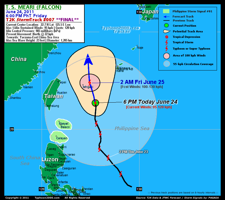
The very large Tropical Storm MEARI (FALCON) is now moving Northward as it approaches the Yaeyama-Ishigakijima Islands...expected to move out of the Philippine Area of Responsibility (PAR) by early tomorrow morning. This storm will continue to pull the Southwest Monsoon bringing rainy & windy conditions across Western Luzon including Metro Manila.
Residents and visitors along Yaeyama-Okinawa-Ryukyu Islands, & Taiwan should closely monitor the progress of MEARI (FALCON).
Do not use this for life or death decision. This advisory is intended for additional information purposes only. Kindly refer to your country's official weather agency for local warnings, advisories & bulletins.
CURRENT STORM INFORMATION
Time/Date: 6:00 PM PhT Fri June 24 2011
Location of Center: 22.7º N Lat 125.5º E Lon
Distance 1: 240 km (130 nm) SSE of Ishigakijima
Distance 2: 425 km (230 nm) ESE of Hualien, Taiwan
Distance 3: 435 km (235 nm) NE of Basco, Batanes
Distance 4: 470 km (253 nm) SE of Taipei, Taiwan
Distance 5: 480 km (260 nm) SW of Okinawa, Japan
Distance 6: 1015 km (548 nm) NNE of Metro Manila
MaxWinds (1-min avg): 95 kph (50 kts) near the center
Peak Wind Gusts: 120 kph (65 kts)
Present Movement: North @ 22 kph (12 kts)
Towards: Yaeyama Island Chain
CPA [ETA] to Taiwan: Sat Early AM [4-5AM HKT]
24hr Rainfall Accum (near center): 300 mm (High)
Rainrate (near center): 25-30 mm/hr (Mod)
Minimum Central Pressure: 985 millibars (hPa)
Saffir-Simpson Typhoon Scale: Tropical Storm
Size (in Diameter): 1,205 km (650 nm) / Very Large
Wind Area Distribution (in Knots): Current Wind Profile
Max Sea Wave Height (near center): 23 ft (7.0 m)
Possible Storm Surge Height: 0-3 ft [0.0-0.9 m]
T2K TrackMap (for Public): 6:00 PM PhT Fri June 24
FORECAST OUTLOOK ANALYSIS (up to 2 days)* MEARI's (FALCON) CLOSEST POINT OF APPROACH (CPA)* EXTENDED FORECAST TRACK (3 days)* EFFECTS & HAZARDS SUMMARY CURRENT SW MONSOON INTENSITY: VERY STRONG >> Cloudy with occasional to widespread moderate to heavy rains w/ squalls & thunderstorms will be expected along the following affected areas: LUZON, METRO MANILA, MINDORO, MARINDUQUE, ROMBLON, BORACAY, SULU SEA, WESTERN & NORTHERN VISAYAS, MASBATE, BICOL REGION, & PALAWAN incl. CALAMIAN GROUP. Moderate to strong SW'ly winds (not in excess of 65 kph) will blow.
MEARI (FALCON) is expected to continue accelerating Northward across the East China Sea for the next 24 to 48 hours and intensify. It will move out of the Philippine Area of Responsibility (PAR) by early tomorrow morning. MEARI shall reach Typhoon intensity (Category 1) sometime tomorrow (Sat) afternoon. Below are the summary of the 2-day forecast for MEARI (FALCON).  TOMORROW EARLY MORNING (FRI): Intensifying as it moves out of PAR...about 80 km ENE of Ishigakijima [2AM JUN 25: 24.8N 124.9E @ 100kph]. TOMORROW AFTERNOON (SAT): Upgraded to a Typhoon while moving across the East China Sea...about 385 km East of Wenzhou, China [2PM JUN 25: 28.0N 124.6E @ 120kph]. SUNDAY EARLY MORNING: Maintains its typhoon strength (Category 1) as it moves into the Yellow Sea...about 290 km SW of Cheju Island, South Korea [2AM JUN 26: 31.4N 124.8E @ 120kph]. SUNDAY MORNING: Turning NNE while passing near the west coast of South Korea...becoming Extratropical...about 90 km away from the West Coast of South Korea [2PM JUN 26: 35.0N 125.4E @ 100kph].
Maximum Sustained Winds (1-min. avg) are near 95 km/hr (50 knots) with higher gusts. MEARI (FALCON) is a Severe Tropical Storm (STS) on the Saffir-Simpson Tropical Cyclone Scale. Continued strengthening will be expected within the next 12 to 24 hours. Tropical Storm Force Winds (62-117 km/hr) extend outward up to 370 kilometers (200 nautical miles) from the center. MEARI is a very large-sized tropical cyclone with a diameter of 1,205 kilometers (650 nautical miles) across. YAEYAMA GROUP OF ISLANDS: About 70 km East of Ishigakijima [ETA: between 1:00-2:00 AM Tomorrow]. MONDAY AFTERNOON: Weakens as it makes landfall and traverses North Korea...attains Extratropical status [2PM JUNE 27: 41.4N 129.0E @ 55kph].
*Please be reminded that the Forecast Outlook changes every 6 hours, and the Extended Forecast Track have an average error of 250 km on Day 3...450 km on Day 4...and 650 km on Day 5, while the wind speed forecast error, averages 35 kph per day. Therefore, a turn to the left or right of its future track and changes in its wind speed must be anticipated from time to time.
MEARI's (FALCON) very large circulation continues to consolidate and strengthen while over the Northern Philippine Sea. Below are the summary of the storm's parts and its hazards affecting specific areas: INNER RAINBANDS - spreading and affecting the Yaeyama Island Chain. Tropical Storm Conditions w/ Tropical Storm Force Winds (62-117 kph) can be expected along these bands. OUTER RAINBANDS - spreading and affecting the Okinawa-Ryukyu Islands and Taiwan. Tropical Depression Conditions w/ moderate to strong winds (30-61 kph) can be expected along these bands (click here to know more about Rainbands). 24HR TOTAL RAINFALL ACCUMULATION - from 5 up to 200 mm (low to high rainfall) can be expected along the outer & inner rainbands...with isolated amounts of up to 300 mm (high) along MEARI's (FALCON) eastern circulation (near Okinawa Island). (click to open NOAA's eTRaP graphic).
Important Note: Please keep in mind that the above forecast outlook, extended forecast, effects-hazards, current monsoon intensity, & tropical cyclone watch changes every 6 to 12 hrs!![]()
PAGASA Philippine Storm Warnings Signals
PHILIPPINE STORM WARNING SIGNAL # ONE (1) 
In Effect: THE CALAYAN-BABUYAN-BATANES GROUP OF ISLANDS.
The above areas will have rains and winds of not more than 60 kph today. Coastal waters will be moderate to rough.
Residents living in low-lying and mountainous areas under Public Storm Warning Signal Number 1 are alerted against flashfloods, mudslides and landslides.
JTWC (US NAVY & AIR FORCE) REMARKS:
REMARKS (for Meteorologists): 2 PM (06 GMT) FRI 24 JUNE POSITION: 21.8N 125.5E.
*TROPICAL STORM (TS) 07W (MEARI), LOCATED APPROXIMATELY 300 NM
SOUTH-SOUTHWEST OF KADENA AIR BASE, JAPAN, HAS TRACKED NORTHWARD AT
12 KNOTS OVER THE PAST SIX HOURS. THE LOW LEVEL CIRCULATION (LLCC)
IS PARTIALLY EXPOSED AND ELONGATED. DURING THE PAST 12 HOURS
CONVECTION HAS INTENSIFIED AND CONSOLIDATED CLOSER TO THE LLCC, YET
THE SYSTEM CONTINUES TO HAVE AN EXPANSIVE, MONSOON DEPRESSION-LIKE
SIGNATURE, WITH SMALL-SCALE VORTICES ROTATING AROUND AND THEN
MERGING WITH THE LLCC. A 240054Z ASCAT PASS PROVIDES AN EXCELLENT
DEPICTION OF THE BREADTH OF THE SYSTEM, AND THE 35 KNOT RADII HAVE
BEEN ADJUSTED OUTWARDS YET AGAIN. A 232222Z SSMIS MICROWAVE PASS
REVEALS EXTENSIVE DEEP CONVECTION THROUGHOUT THE SOUTHERN
SEMICIRCLE, WHEREAS DEEP CONVECTION OVER THE NORTHEAST QUADRANT IS
SPOTTY. THE 37GHZ SLICE OF THE SAME IMAGE IN TANDEM WITH 1 KM VISUAL
IMAGERY SHOWS A DEARTH OF CLOUD COVER OVER THE WESTERN QUADRANT.
TOTAL PRECIPITABLE WATER LOOPS HINT AT SOME DRY AIR FEEDING INTO THE
SYSTEM CENTER FROM THE NORTHWEST, BUT THE CLEAR POCKET IS TOO FAR
REMOVED FROM ANY AIR MASS DISCONTINUITY TO ATTRIBUTE THE CLEARING TO
DRY AIR. IT IS MORE LIKELY AN EFFECT OF THE SUBSIDENT UPPER
ATMOSPHERE OVER THE NORTHWESTERN QUADRANT. THE SUBSIDENCE IS
REPRESENTED CLEARLY ON WATER VAPOR ANIMATION, WHICH SHOWS
NORTHWESTERLIES SURGING OVER THE TAIWAN STRAIT AND TURNING
CYCLONICALLY SOUTH OF TAIWAN, THE BEGINNINGS OF YET ANOTHER UPPER
LOW. EQUATORWARD OUTFLOW REMAINS VIGOROUS AND OUTFLOW TO THE
NORTHEAST HAS IMPROVED SIGNIFICANTLY DURING THE PAST 24 HOURS. THE
CURRENT INTENSITY ASSESSMENT IS BASED PRIMARILY ON THE ASCAT PASS,
AS THE LACK OF CORE CONVECTION IS MAKING DVORAK ESTIMATES LESS
REPRESENTATIVE. CURRENTLY TS 07W IS UNDER ONLY 5 TO 10 KNOTS OF
VERTICAL WIND SHEAR, AND WIND SHEAR IS EXPECTED TO STAY BELOW 15
KNOTS UNTIL THE STORM ROUNDS THE RIDGE NEAR 30N. THIS WILL ALLOW TS
07W TO INTENSIFY TO MARGINAL TYPHOON STRENGTH AS IT ROUNDS THE CREST
OF THE RIDGE. THE SYSTEM IS TRACKING ALONG THE WESTERN SPINE OF A
HIGH AMPLITUDE RIDGE THAT EXTENDS FROM THE PHILIPPINE SEA TO
SOUTHERN JAPAN BETWEEN 130E AND 135E. ONCE MEARI CRESTS THE RIDGE,
THE STORM WILL ENCOUNTER A SHARP DROP IN SEA SURFACE TEMPERATURES
AND BEGIN WEAKENING. THE EXTRATROPICAL TRANSITION PROCESS WILL BEGIN
AS THE SYSTEM MOVES INTO THE YELLOW SEA, AND COMPLETE BEFORE IT
FINISHES CROSSING THE KOREAN PENINSULA. MODEL GUIDANCE HAS COME INTO
TIGHTER AGREEMENT REGARDING THE EXTENDED TRACK, WITH ALL CONSENSUS
MEMBERS TRACKING THE SYSTEM INTO THE YELLOW SEA. THERE REMAINS
CONSIDERABLE UNCERTAINTY AS TO WHETHER THE SYSTEM WILL TRACK NORTH
OR SOUTH OF SEOUL, BUT THE MAJORITY OF MODEL GUIDANCE SUGGESTS THE
SYSTEM WILL GO NORTH OF SEOUL. AT THIS JUNCTURE, ONLY THE JAPANESE
MODEL TRACKS THE STORM THROUGH SOUTH KOREA. THROUGH TAU 48, THERE IS
EXCELLENT AGREEMENT ON BOTH TRACK AND INTENSITY...(more info)
>> MEARI, meaning: Reflection of sound or echo. Name contributed by: DPR Korea.
_______________________________________________________________________________________________________________________________________
RECENT TYPHOON2000.COM (JTWC) TRACKING CHART:
_________________________________________________________________________________________________________________
RECENT MULTI-AGENCY TROPICAL CYCLONE FORECAST TRACKING CHART: 

> Image source: NOAA SATELLITE CENTER: http://www.ssd.noaa.gov/mtsat/flt/t1/rgb.jpg
> Image source: Wunderground.com Tropical Page (http://www.wunderground.com/tropical)
____________________________________________________________________________________________________________________
LATEST 24HR. TOTAL RAINFALL AMOUNTS / ENSEMBLE TROPICAL RAINFALL POTENTIAL (eTRaP):

> Image source: NOAA Satellite & Information Service (http://www.ssd.noaa.gov/PS/TROP/etrap.html)
>> To know the meteorological terminologies and acronyms used on this update visit the ff:
http://typhoon2000.ph/tcterm.htm
http://www.nhc.noaa.gov/aboutgloss.shtml
http://www.srh.noaa.gov/oun/severewx/glossary.php
http://www.srh.weather.gov/fwd/glossarynation.html
http://www.nhc.noaa.gov/acronyms.shtml
__________________________________________________________________________________________
For the complete details on TS MEARI (FALCON)...go visit our website @:
> http://www.typhoon2000.com
> http://www.maybagyo.com
Copyright © 2011 Typhoon2000.com All Rights Reserved

No comments:
Post a Comment