
for Thursday, 23 June 2011 [7:00 AM PhT]

<<<Typhoon2000.com Mobile >>>
Get the latest 6-hrly SMS Storm Alerts on FALCON!
For more details: Text T2K TYPHOON to
2800 (Globe/TM) | 216 (Smart/TNT) | 2288 (Sun)
*Only P2.50 (Smart/Globe) / P2.00 (Sun) per msg received.
Click here on how to use this service (in PDF file)
Powered by: Synermaxx Corporation
Typhoon2000 (T2K) NEWS (Wednesday June 22 2011):
Currently issuing 6-hrly web, SMS, Twitter and e-mail updates (except 12:00 Midnight) on TS MEARI (FALCON).
MEARI (FALCON) MAX WIND SPEED PER AGENCY:
+ USA (JTWC/1-min avg): 75 km/hr
+ Japan (JMA/10-min avg): 65 km/hr
+ Philippines (PAGASA/10-min avg): 65 km/hr
+ Korea (KMA/10-min avg): 75 km/hr
+ Taiwan (CWB/10-min avg): 65 km/hr
+ Beijing (NMC/2-min avg): 65 km/hr
:: Click here to see Multi-Agency Forecast Tracks
TROPICAL STORM MEARI [FALCON/07W/1105]
T2K PUBLIC ADVISORY NUMBER 010
6:00 AM PhT (22:00 GMT) Thu 23 June 2011
Sources: T2K Extrap Analysis/JTWC Warning #005/SatFixes
View: Advisory Archives (2004-2011)
The large Tropical Storm MEARI (FALCON) has slowed down and relocated in between the area of two circulations while still over the Philippine Sea. MEARI will continue to suck the SW Monsoon and bring occasional to widespread rains across Palawan, Visayas & Mindanao.
Residents and visitors along Central & Northern Luzon, Batanes-Calayan-Babuyan Islands, Yaeyama-Okinawa-Ryukyu Islands, & Taiwan should closely monitor the progress of MEARI (FALCON).
Do not use this for life or death decision. This advisory is intended for additional information purposes only. Kindly refer to your country's official weather agency for local warnings, advisories & bulletins.
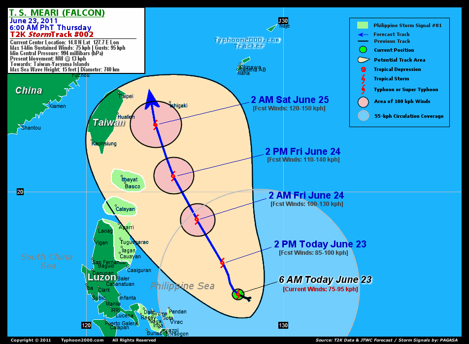
CURRENT STORM INFORMATION
Time/Date: 6:00 AM PhT Thu June 23 2011
Location of Center: 14.8º N Lat 127.7º E Lon
Distance 1: 385 km (208 nm) ENE of Pandan, Catanduanes
Distance 2: 390 km (210 nm) ENE of Virac, Catanduanes
Distance 3: 505 km (273 nm) ENE of Metro Naga/CWC
Distance 4: 620 km (335 nm) ESE of Casiguran, Aurora
Distance 5: 645 km (348 nm) East of Infanta, Quezon
Distance 6: 720 km (388 nm) East of Metro Manila
MaxWinds (1-min avg): 75 kph (40 kts) near the center
Peak Wind Gusts: 95 kph (50 kts)
Present Movement: NW @ 13 kph (07 kts)
Towards: Taiwan-Yaeyama Area
CPA [ETA] to Taiwan: Sat Morning [11AM-1PM HKT]
24hr Rainfall Accum (near center): 380 mm (High)
Rainrate (near center): 20-30 mm/hr (Mod)
Minimum Central Pressure: 993 millibars (hPa)
Saffir-Simpson Typhoon Scale: Tropical Storm
Size (in Diameter): 740 km (400 nm) / Large
Wind Area Distribution (in Knots): Current Wind Profile
Max Sea Wave Height (near center): 15 ft (4.5 m)
Possible Storm Surge Height: 0 ft [0 m]
T2K TrackMap (for Public): 6:00 AM PhT Thu June 23
FORECAST OUTLOOK ANALYSIS (up to 2 days)* MEARI's (FALCON) CLOSEST POINT OF APPROACH (CPA)* EXTENDED FORECAST TRACK (3 to 5 days)* EFFECTS & HAZARDS SUMMARY CURRENT SW MONSOON INTENSITY: STRONG >> Mostly cloudy with widespread moderate to heavy on-&-off rains w/ squalls & thunderstorms will be expected along the following affected areas: SULU SEA, VISAYAS, MASBATE, NORTHERN PALAWAN & MINDANAO. Light to moderate SW'ly winds (not in excess of 40 kph) will blow.
MEARI (FALCON) is expected to track NNW across the warm Philippine Sea and will continue to intensify for the next 24-48 hours. MEARI shall reach Typhoon status (Category 1) on Friday evening or early Saturday morning while to the east of Taiwan. Below are the summary of the 2-day forecast for MEARI (FALCON).  THIS AFTERNOON (THU): Intensifying over the warm waters of the Philippine Sea...about 515 km ENE of Casiguran, Aurora [2PM JUN 23: 16.4N 126.9E @ 85kph]. TOMORROW EARLY MORNING (FRI): Continues to intensify while passing well to the east of Cagayan Province (still over the Philippine Sea)...about 410 km ENE of Aparri, Cagayan [2AM JUN 24: 18.6N 125.6E @ 100kph]. TOMORROW AFTERNOON (FRI): Almost a Category 1 Typhoon...passing well to the east of Batanes Group of Islands...about 250 km ENE of Basco [2PM JUN 24: 20.8N 124.4E @ 110kph]. SATURDAY EARLY MORNING: Upgraded to a typhoon as it approaches the coast of Eastern Taiwan and the Yaeyama Group of Islands...turning northward...about 205 km ESE of Hualien City, Taiwan [2AM JUN 25: 23.4N 123.5E @ 120kph].
Maximum Sustained Winds (1-min. avg) are near 75 km/hr (40 knots) with higher gusts. MEARI (FALCON) is a Tropical Storm (TS) on the Saffir-Simpson Tropical Cyclone Scale. Some strengthening expected within the next 12 to 24 hours. Tropical Storm Force Winds (62-95 km/hr) extend outward up to 185 kilometers (100 nautical miles) from the center. MEARI is a large-sized tropical cyclone with a diameter of 740 kilometers (400 nautical miles). YAEYAMA GROUP OF ISLANDS: About 80 km East of Ishigakijima [ETA: between 7:00-8:00 AM HKT Saturday, June 25]. EASTERN TAIWAN: About 170 km East of Taipei [ETA: between 8:00-9:00 AM HKT Saturday, June 25]. SUNDAY EARLY MORNING: Maintaining its typhoon status as it moves North to NNE along the East China Sea...brushing the coast of Eastern China [2AM JUNE 26: 28.0N 123.1E @ 120kph]. MONDAY EARLY MORNING: Downgraded to a Tropical Storm (TS) as it accelerates NNE along the Yellow Sea and approaching the west coast of the Korean Peninsula...becoming Extratropical [2AM JUNE 27: 34.9N 125.1E @ 75kph]. TUESDAY EARLY MORNING: Attains Extratropical status as it moves swiftly across Eastern Russia [2AM JUNE 28: 43.3N 130.3E @ 55kph].
*Please be reminded that the Forecast Outlook changes every 6 hours, and the Extended Forecast Track have an average error of 250 km on Day 3...450 km on Day 4...and 650 km on Day 5, while the wind speed forecast error, averages 35 kph per day. Therefore, a turn to the left or right of its future track and changes in its wind speed must be anticipated from time to time.
MEARI's (FALCON) broad circulation continues to consolidate and strengthen while over the warm Philippine Sea with its western outer rainbands affecting the Bicol Region and Eastern Visayas. Below are the summary of the depression's parts and its hazards affecting specific areas: INNER RAINBANDS - over water (off Central Philippine Sea)...not affecting any land areas. Tropical Storm Conditions w/ Tropical Storm Force Winds (65-85 kph) can be expected along these bands. OUTER RAINBANDS - affecting & spreading along the Bicol Region and Eastern Visayas. Tropical Depression Conditions w/ moderate to strong winds (30-61 kph) can be expected along these bands (click here to know more about Rainbands). 24HR TOTAL RAINFALL ACCUMULATION - from 5 up to 200 mm (low to high rainfall) can be expected along the outer & inner rainbands...with isolated amounts of up to 380 mm (high) along MEARI's (FALCON) western circulation (near Catanduanes). (click to open NOAA's eTRaP graphic).
Important Note: Please keep in mind that the above forecast outlook, extended forecast, effects-hazards, current monsoon intensity, & tropical cyclone watch changes every 6 to 12 hrs!![]()
PAGASA Philippine Storm Warnings Signals
PHILIPPINE STORM WARNING SIGNAL # ONE (1) 
Now In Effect: ALBAY, CATANDUANES, CAMARINES SUR, CAMARINES NORTE, ISABELA, CAGAYAN, & THE CALAYAN-BABUYAN-BATANES GROUP OF ISLANDS.
The above areas will have rains and winds of not more than 60 kph today. Coastal waters will be moderate to rough.
Residents living in low-lying and mountainous areas under Public Storm Warning Signal Number 1 are alerted against flashfloods, mudslides and landslides.
JTWC (US NAVY & AIR FORCE) REMARKS:
REMARKS (for Meteorologists): 2 AM (18 GMT) THU 23 JUNE POSITION: 14.8N 128.0E.
*TROPICAL STORM (TS) 07W (MEARI), LOCATED APPROXIMATELY 405 NM EAST
OF MANILA, PHILIPPINES, HAS TRACKED NORTHWESTWARD AT 08 KNOTS OVER
THE PAST SIX HOURS. THE SYSTEM CENTER HAS BEEN RELOCATED TO THE
SOUTHEAST OF THE PREVIOUS POSITION. RECENT ANIMATED INFRARED AND
MICROWAVE SATELLITE IMAGERY AND SCATTEROMETER DATA INDICATES AN
EXPANSIVE LOW LEVEL CIRCULATION WITH DISTINCT EMBEDDED VORTICES AND
ASSOCIATED CONVECTION ON THE EASTERN AND WESTERN PERIPHERIES. THESE
SMALLER VORTICES ARE ROTATING ABOUT A CENTROID REPRESENTED BY THE
CURRENT BEST TRACK POSITION, WHICH IS ALSO APPROXIMATED IN RECENT
PGTW AND RJTD SATELLITE FIXES AND A 221735Z AMSU IMAGE. THE CURRENT
INTENSITY ESTIMATE OF 35 KNOTS IS CONSISTENT WITH A 2.5 DVORAK T-
NUMBER ESTIMATE FROM PGTW AND A 221240Z ASCAT PASS. TS 07W IS
TRACKING NORTHWESTWARD ALONG THE SOUTHWESTERN PERIPHERY OF A
SUBTROPICAL STEERING RIDGE TO THE NORTHEAST. THIS SYSTEM IS EXPECTED
TO ROUND THE AXIS OF THIS STEERING RIDGE AHEAD OF AN APPROACHING MID-
LATITUDE TROUGH DURING THE FORECAST PERIOD. THE CYCLONE WILL
INTERACT WITH THE TROUGH AFTER TAU 72, AND IS NOW EXPECTED TO
UNDERGO EXTRATROPICAL TRANSITION SINCE THE TRACK FORECAST HAS BEEN
SHIFTED TO THE EAST AND THE CYCLONE WILL THUS MAINTAIN INTENSITY
ABOVE 25 KNOTS. THIS EASTWARD SHIFT IN THE TRACK FORECAST IS
PRIMARILY DUE TO ADJUSTMENT OF THE ANALYSIS POSITION AND NOT A SHIFT
IN THE NUMERICAL MODEL GUIDANCE. TS 06W IS EXPECTED TO REACH TYPHOON
INTENSITY BY TAU 36 AS PASSAGE OVER WARM WATER AND GOOD UPPER LEVEL
OUTFLOW SUPPORT INTENSIFICATION, WHILE FURTHER CONSOLIDATION OF THE
LOW LEVEL CIRCULATION INHIBITS RAPID DEVELOPMENT. THE CURRENT TRACK
FORECAST IS IN GOOD AGREEMENT WITH THE MAJORITY OF THE NUMERICAL
MODEL GUIDANCE, INCLUDING THE LATEST ECMWF, JGSM, UKMET, AND GFS
RUNS. THE NOGAPS AND GFDN MODELS DEPICT A TRACK A BIT FARTHER TO THE
EAST, A SCENARIO DEEMED UNLIKELY GIVEN THE OTHER MODEL GUIDANCE AND
CURRENT SYNOPTIC REASONING...(more info)
>> MEARI, meaning: Reflection of sound or echo. Name contributed by: DPR Korea.
_______________________________________________________________________________________________________________________________________
RECENT TYPHOON2000.COM (JTWC) TRACKING CHART:
_________________________________________________________________________________________________________________
RECENT MULTI-AGENCY TROPICAL CYCLONE FORECAST TRACKING CHART: 
_________________________________________________________________________________________________________________

> Image source: NOAA SATELLITE CENTER: http://www.ssd.noaa.gov/mtsat/flt/t1/rgb.jpg
> Image source: Wunderground.com Tropical Page (http://www.wunderground.com/tropical)
____________________________________________________________________________________________________________________
LATEST 24 HR. TOTAL RAINFALL AMOUNTS / ENSEMBLE TROPICAL RAINFALL POTENTIAL (eTRaP):

> Image source: NOAA Satellite & Information Service (http://www.ssd.noaa.gov/PS/TROP/etrap.html)
>> To know the meteorological terminologies and acronyms used on this update visit the ff:
http://typhoon2000.ph/tcterm.htm
http://www.nhc.noaa.gov/aboutgloss.shtml
http://www.srh.noaa.gov/oun/severewx/glossary.php
http://www.srh.weather.gov/fwd/glossarynation.html
http://www.nhc.noaa.gov/acronyms.shtml
__________________________________________________________________________________________
For the complete details on TS MEARI (FALCON)...go visit our website @:
> http://www.typhoon2000.com
> http://www.maybagyo.com
Copyright © 2011 Typhoon2000.com All Rights Reserved

No comments:
Post a Comment