
for Friday, 24 June 2011 [7:20 AM PhT]![]()

<<<Typhoon2000.com Mobile >>>
Get the latest 6-hrly SMS Storm Alerts on FALCON!
For more details: Text T2K TYPHOON to
2800 (Globe/TM) | 216 (Smart/TNT) | 2288 (Sun)
*Only P2.50 (Smart/Globe) / P2.00 (Sun) per msg received.
Click here on how to use this service (in PDF file)
Powered by: Synermaxx Corporation
Typhoon2000 (T2K) NEWS (Wednesday June 22 2011):
Currently issuing 6-hrly web, SMS, Twitter and e-mail updates (except 12:00 Midnight) on TS MEARI (FALCON).
MEARI (FALCON) MAX WIND SPEED PER AGENCY:
+ USA (JTWC/1-min avg): 85 km/hr
+ Japan (JMA/10-min avg): 75 km/hr
+ Philippines (PAGASA/10-min avg): 85 km/hr
+ Korea (KMA/10-min avg): 85 km/hr
+ Taiwan (CWB/10-min avg): 85 km/hr
+ Beijing (NMC/2-min avg): 75 km/hr
+ Hong Kong (HKO/10-min avg): 75 km/hr
:: Click here to see Multi-Agency Forecast Tracks
TROPICAL STORM MEARI [FALCON/07W/1105]
T2K PUBLIC ADVISORY NUMBER 013
6:00 AM PhT (22:00 GMT) Fri 24 June 2011
Sources: T2K Extrap Analysis/JTWC Warning #008/SatFixes
View: Advisory Archives (2004-2011)
Tropical Storm MEARI (FALCON) has accelerated and intensified while passing well to the east of the Batanes Group of Islands...it remains a very large system w/ a diameter of 1,200 km. This storm continues to pull the Southwest Monsoon across the Philippines - bringing occasional rains particularly along the western sections.
Residents and visitors along Extreme Northern Luzon, Batanes-Calayan-Babuyan Islands, Yaeyama-Okinawa-Ryukyu Islands, & Taiwan should closely monitor the progress of MEARI (FALCON).
Do not use this for life or death decision. This advisory is intended for additional information purposes only. Kindly refer to your country's official weather agency for local warnings, advisories & bulletins.
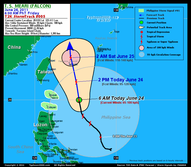
CURRENT STORM INFORMATION
Time/Date: 6:00 AM PhT Fri June 24 2011
Location of Center: 20.0º N Lat 125.4º E Lon
Distance 1: 360 km (195 nm) ESE of Basco, Batanes
Distance 2: 385 km (207 nm) ESE of Itbayat, Batanes
Distance 3: 435 km (233 nm) ENE of Aparri, Cagayan
Distance 4: 515 km (278 nm) SSE of Ishigakijima
Distance 5: 680 km (368 nm) SE of Taipei, Taiwan
Distance 6: 760 km (410 nm) NE of Metro Manila
MaxWinds (1-min avg): 85 kph (45 kts) near the center
Peak Wind Gusts: 100 kph (55 kts)
Present Movement: NNW @ 26 kph (14 kts)
Towards: Yaeyama Island Chain
CPA [ETA] to Taiwan: Sat Early AM [2-3AM HKT]
24hr Rainfall Accum (near center): 300 mm (High)
Rainrate (near center): 20-30 mm/hr (Mod)
Minimum Central Pressure: 989 millibars (hPa)
Saffir-Simpson Typhoon Scale: Tropical Storm
Size (in Diameter): 1,205 km (650 nm) / Very Large
Wind Area Distribution (in Knots): Current Wind Profile
Max Sea Wave Height (near center): 19 ft (5.7 m)
Possible Storm Surge Height: 0-3 ft [0.0-0.9 m]
T2K TrackMap (for Public): 6:00 AM PhT Fri June 24
FORECAST OUTLOOK ANALYSIS (up to 2 days)* MEARI's (FALCON) CLOSEST POINT OF APPROACH (CPA)* EXTENDED FORECAST TRACK (3 to 4 days)* EFFECTS & HAZARDS SUMMARY CURRENT SW MONSOON INTENSITY: STRONG >> Mostly cloudy with widespread moderate to heavy on-&-off rains w/ squalls & thunderstorms will be expected along the following affected areas: REST OF LUZON, METRO MANILA, MINDORO, MARINDUQUE, ROMBLON, SULU SEA, VISAYAS, MASBATE,BICOL REGION, PALAWAN & MINDANAO. Moderate to strong SW'ly winds (not in excess of 65 kph) will blow.
MEARI (FALCON) is expected to continue accelerating NNW-ward across the Northern Philippine Sea and will continue to intensify for the next 24 to 48 hours. MEARI shall reach Typhoon status (Category 1) by tomorrow (Sat) afternoon, upon exiting the Philippine Area of Responsibility (PAR) and shall turn northward as it moves across East China Sea. Below are the summary of the 2-day forecast for MEARI (FALCON).  THIS AFTERNOON (FRI): Intensifying over the warm waters of the Philippine Sea as it tracks NNW...about 270 km SSE of Ishigakijima [2PM JUN 24: 22.2N 125.1E @ 95kph]. TOMORROW EARLY MORNING (SAT): Exits the Philippine Area of Responsibility (PAR) after passing over the Yaeyama Island Chain...about 80 km NNE of Ishigakijima [2AM JUN 25: 25.2N 124.4E @ 110kph]. SATURDAY AFTERNOON: Becomes a Typhoon as it moves faster northward across the East China Sea...about 310 km ESE of Ningbo, China [2PM JUN 25: 28.3N 124.1E @ 120kph]. SUNDAY EARLY MORNING: Starts to lose strength as it enters the Yellow Sea...becoming Extratropical...about 270 km ENE of Shanghai, China [2AM JUN 26: 31.7N 124.2E @ 110kph].
Maximum Sustained Winds (1-min. avg) are near 85 km/hr (45 knots) with higher gusts. MEARI (FALCON) is a Tropical Storm (TS) on the Saffir-Simpson Tropical Cyclone Scale. Continued strengthening will be expected within the next 12 to 24 hours. Tropical Storm Force Winds (62-95 km/hr) extend outward up to 315 kilometers (170 nautical miles) from the center. MEARI is a very large-sized tropical cyclone with a diameter of 1,205 kilometers (650 nautical miles). YAEYAMA GROUP OF ISLANDS: About 30 km ENE of Ishigakijima [ETA: between 12:00-1:00 AM HKT Saturday, June 25]. MONDAY EARLY MORNING: Makes landfall over North Korea...attains Extratropical status [2AM JUNE 27: 38.7N 125.7E @ 75kph]. TUESDAY EARLY MORNING: Passing over Eastern Russia as an Extratropical Cyclone [2AM JUNE 28: 44.8N 131.1E @ 45kph].
*Please be reminded that the Forecast Outlook changes every 6 hours, and the Extended Forecast Track have an average error of 250 km on Day 3...450 km on Day 4...and 650 km on Day 5, while the wind speed forecast error, averages 35 kph per day. Therefore, a turn to the left or right of its future track and changes in its wind speed must be anticipated from time to time.
MEARI's (FALCON) very large circulation continues to consolidate and strengthen while over the Northern Philippine Sea with its southwestern & western outer rainbands affecting the eastern coast of Luzon. Below are the summary of the depression's parts and its hazards affecting specific areas: INNER RAINBANDS - over water (off North-Central Philippine Sea)...not affecting any land areas. Tropical Storm Conditions w/ Tropical Storm Force Winds (62-95 kph) can be expected along these bands. OUTER RAINBANDS - affecting & spreading along the Eastern Coast of Luzon. Tropical Depression Conditions w/ moderate to strong winds (30-61 kph) can be expected along these bands (click here to know more about Rainbands). 24HR TOTAL RAINFALL ACCUMULATION - from 5 up to 150 mm (low to high rainfall) can be expected along the outer & inner rainbands...with isolated amounts of up to 300 mm (high) along MEARI's (FALCON) western circulation (near Batanes Group). (click to open NOAA's eTRaP graphic).
Important Note: Please keep in mind that the above forecast outlook, extended forecast, effects-hazards, current monsoon intensity, & tropical cyclone watch changes every 6 to 12 hrs!![]()
PAGASA Philippine Storm Warnings Signals
PHILIPPINE STORM WARNING SIGNAL # ONE (1) 
In Effect: THE CALAYAN-BABUYAN-BATANES GROUP OF ISLANDS.
The above areas will have rains and winds of not more than 60 kph today. Coastal waters will be moderate to rough.
Residents living in low-lying and mountainous areas under Public Storm Warning Signal Number 1 are alerted against flashfloods, mudslides and landslides.
JTWC (US NAVY & AIR FORCE) REMARKS:
REMARKS (for Meteorologists): 2 AM (18 GMT) FRI 24 JUNE POSITION: 19.5N 126.0E.
*TROPICAL STORM (TS) 07W (MEARI), LOCATED APPROXIMATELY 435
SOUTH-SOUTHWEST OF KADENA AIR BASE, JAPAN, HAS TRACKED NORTH-
NORTHWESTWARD AT 14 KNOTS OVER THE PAST SIX HOURS. NUMEROUS SMALL-
SCALE VORTICES CONTINUE TO DEVELOP ALONG AND ROTATE AROUND THE
PERIPHERY OF TS 07W. HOWEVER, THE CENTER OF THE BROADER CIRCULATION
HAS CONSOLIDATED A BIT OVER THE PAST SIX HOURS AND IS THEREFORE MORE
READILY IDENTIFIED IN SATELLITE IMAGERY. THE CURRENT POSITION IS
BASED ON RECENT MICROWAVE SATELLITE IMAGES, INCLUDING A 231659Z AMSR-
E PASS. THE CURRENT INTENSITY ESTIMATE OF 45 KNOTS IS CONSISTENT
WITH WIND SPEEDS INDICATED IN A 231220Z ASCAT PASS. TS 07W IS
TRACKING POLEWARD ALONG THE WESTERN PERIPHERY OF A SUBTROPICAL
STEERING RIDGE TO THE EAST. THE 35 KNOT WIND RADII HAVE BEEN
ADJUSTED SLIGHTLY LARGER IN BOTH THE ANALYSIS AND FORECAST BASED ON
THE ASCAT PASS, WHICH SHOWS AN EXPANSIVE GALE AREA TO THE EAST AND
NORTH OF THE CIRCULATION CENTER. TS 07W WILL CONTINUE TO TRACK
POLEWARD ALONG THE WESTERN PERIPHERY OF THE CURRENT STEERING RIDGE
THROUGH THE FORECAST PERIOD. MODERATE VERTICAL WIND SHEAR AND
SUBSIDENCE ALOFT INTRODUCED BY INTERACTION WITH AN UPPER-LEVEL LOW
WILL VIE WITH STRONG EQUATORWARD OUTFLOW TO LIMIT THE
INTENSIFICATION RATE FOR THE NEXT 36 HOURS. BETWEEN TAU 48 AND TAU
72, THE SYSTEM WILL UNDERGO EXTRATROPICAL TRANSITION AND WEAKEN
UNDER THE INFLUENCE OF INCREASING VERTICAL WIND SHEAR AND PASSAGE
OVER COOLER WATER...(more info)
>> MEARI, meaning: Reflection of sound or echo. Name contributed by: DPR Korea.
_______________________________________________________________________________________________________________________________________
RECENT TYPHOON2000.COM (JTWC) TRACKING CHART:
_________________________________________________________________________________________________________________
RECENT MULTI-AGENCY TROPICAL CYCLONE FORECAST TRACKING CHART: 

> Image source: NOAA SATELLITE CENTER: http://www.ssd.noaa.gov/mtsat/flt/t1/rgb.jpg
> Image source: Wunderground.com Tropical Page (http://www.wunderground.com/tropical)
____________________________________________________________________________________________________________________
LATEST 24HR. TOTAL RAINFALL AMOUNTS / ENSEMBLE TROPICAL RAINFALL POTENTIAL (eTRaP):

> Image source: NOAA Satellite & Information Service (http://www.ssd.noaa.gov/PS/TROP/etrap.html)
>> To know the meteorological terminologies and acronyms used on this update visit the ff:
http://typhoon2000.ph/tcterm.htm
http://www.nhc.noaa.gov/aboutgloss.shtml
http://www.srh.noaa.gov/oun/severewx/glossary.php
http://www.srh.weather.gov/fwd/glossarynation.html
http://www.nhc.noaa.gov/acronyms.shtml
__________________________________________________________________________________________
For the complete details on TS MEARI (FALCON)...go visit our website @:
> http://www.typhoon2000.com
> http://www.maybagyo.com
Copyright © 2011 Typhoon2000.com All Rights Reserved

No comments:
Post a Comment