
for Saturday, 18 June 2011 [1:55 AM PhT]![]()

<<<Typhoon2000.com Mobile >>>
Get the latest 3-hrly SMS Storm Alerts on EGAY!
For more details: Text T2K HELP to
2800 (Globe/TM) | 216 (Smart/TNT) | 2288 (Sun)
*Only P2.50 (Smart/Globe) / P2.00 (Sun) per msg received.
Click here on how to use this service (in PDF file)
Powered by: Synermaxx Corporation
Typhoon2000 (T2K) NEWS (Friday June 17 2011):
Now issuing 3-hrly web, twitter and e-mail updates (except 12:00 Midnight) on the newly-formed TD 06W (EGAY) located off the Philippine Sea.
06W (EGAY) MAX WIND SPEED PER AGENCY:
+ USA (JTWC/1-min avg): 45 km/hr
+ Japan (JMA/10-min avg): 55 km/hr
+ Philippines (PAGASA/10-min avg): 55 km/hr
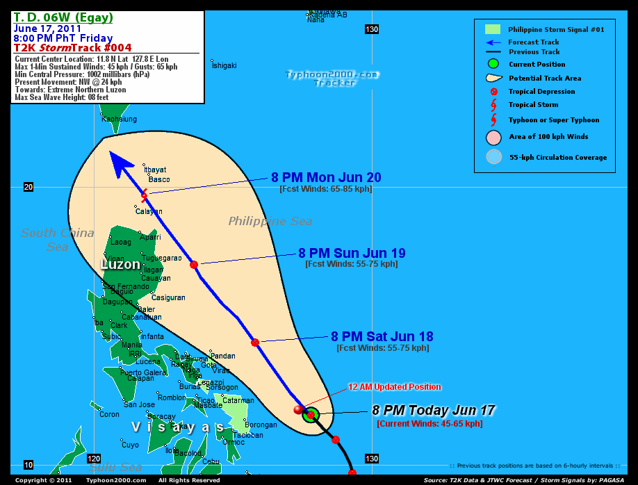
TROPICAL DEPRESSION 06W [EGAY]
T2K PUBLIC ADVISORY NUMBER 004
12:00 AM PhT (16:00 GMT) Sat 18 June 2011
Sources: T2K Extrap Analysis/JTWC Warning #004/SatFixes
View: Advisory Archives (2004-2011)
Tropical Depression 06W (EGAY) resumes its NW'ly track closer to the coast of Northern Samar and Bicol Region.
Residents and visitors along the Eastern Coast of Luzon & Visayas should closely monitor the progress of 06W (EGAY).
Do not use this for life or death decision. This advisory is intended for additional information purposes only. Kindly refer to your country's official weather agency for local warnings, advisories & bulletins.
CURRENT STORM INFORMATION
Time/Date: 12:00 AM PhT Sat June 18 2011
Location of Center: 11.9º N Lat 127.5º E Lon
Distance 1: 230 km (125 nm) ENE of Borongan City
Distance 2: 310 km (167 nm) ESE of Catarman, N.Samar
Distance 3: 400 km (215 nm) SE of Virac, Catanduanes
Distance 4: 435 km (235 nm) ESE of Legazpi City
Distance 5: 505 km (273 nm) SE of Metro Naga/CWC
MaxWinds (1-min avg): 45 kph (25 kts) near the center
Peak Wind Gusts: 65 kph (35 kts)
Present Movement: NW @ 24 kph (13 kts)
Towards: Bicol's East Coast
CPA [ETA] to Bicol: Tonight-Sunday Morning [8PM-2AM PhT]
24hr Rainfall Accum (near center): 350 mm (High)
Minimum Central Pressure: 1002 millibars (hPa)
Saffir-Simpson Typhoon Scale: TD
Size (in Diameter): --- km (--- nm) / N/A
Wind Area Distribution (in Knots): Current Wind Profile
Max Sea Wave Height (near center): 08 ft (2.4 m)
Possible Storm Surge Height: 0 ft [0 m]
T2K TrackMap (for Public): 12:00 AM PhT Sat June 18
FORECAST OUTLOOK ANALYSIS (up to 2 days)* 06W's CLOSEST POINT OF APPROACH (CPA)* EXTENDED FORECAST TRACK (3 to 5 days)* EFFECTS & HAZARDS SUMMARY Important Note: Please keep in mind that the above forecast outlook, extended forecast, effects-hazards, current monsoon intensity, & tropical cyclone watch changes every 6 to 12 hrs! PHILIPPINE STORM WARNING SIGNAL # ONE (1) The above areas will have rains and winds of not more than 60 kph today. Coastal waters will be moderate to rough.
06W (EGAY) is expected to slightly turn NW and intensify into a tropical storm within the next 48 hours, passing to the NE of Bicol Region by early Sunday morning, June 19. THIS MORNING (SAT): Over the Philippine Sea but approaching Bicol...about 345 km East of Legazpi City, PH [8AM JUN 18: 13.1N 126.9E @ 45kph]. THIS EVENING (SAT): Slightly intensifies while passing well to the ENE of Bicol...about 175 km ENE of Pandan, Catanduanes, PH [8PM JUN 18: 14.4N 125.8E @ 55kph]. TOMORROW MORNING (SUN): Maintains TD strength while over the Philippine Sea...about 280 km ESE of Casiguran, Aurora, PH [8AM JUN 19: 15.8N 124.7E @ 55kph]. TOMORROW EVENING (SUN): Passing near the coast of Isabela-Cagayan Area...about 190 km East of Ilagan City, Isabela, PH [8PM JUN 19: 17.2N 123.6E @ 55kph].
Maximum Sustained Winds (1-min. avg) are near 45 km/hr (25 knots) with higher gusts. SARIKA (DODONG) is a weak Tropical Depression (TD) on the Saffir-Simpson Tropical Cyclone Scale. CATANDUANES: about 160 km NE of Pandan or 195 km NE of Virac [ETA: between 8:00 PM tonight-2:00 AM Sunday, June 19]. MONDAY EVENING: Reaches minimal TS strength as it passes over Batanes [8PM JUNE 20: 19.7N 121.8E @ 65kph]. TUESDAY EVENING: Passing very close to the SW Coast of Taiwan [8PM JUNE 21: 22.1N 120.0E @ 65kph]. WEDNESDAY EVENING: Weakens into a Tropical Depression (TD) as it prepares to make landfall off SE China [8PM JUNE 22: 24.2N 118.3E @ 35kph].
*Please be reminded that the Forecast Outlook changes every 6 hours, and the Extended Forecast Track have an average error of 250 km on Day 3...450 km on Day 4...and 650 km on Day 5, while the wind speed forecast error, averages 35 kph per day. Therefore, a turn to the left or right of its future track and changes in its wind speed must be anticipated from time to time.
06W's (EGAY) circulation becoming slightly better organized w/ still most of its rain-cloud convection displaced West & NW of its low-level center. Below are the summary of the depression's parts and its hazards affecting specific areas: DEVELOPING RAINBANDS - affecting & spreading across Bicol Region, Eastern & Central Visayas, and Northeastern Mindanao. Tropical Depression Conditions w/ moderate to strong winds (30-61 kph) can be expected along these bands (click here to know more about Rainbands). 24HR TOTAL RAINFALL ACCUMULATION - from 5 up to 100 mm (low to medium rainfall) can be expected along the outer & inner rainbands...with isolated amounts of up to 350 mm (high) near the center of 06W (EGAY). (click to open NOAA's eTRaP graphic). ![]()
PAGASA Philippine Storm Warnings Signals

Now In Effect: CATANDUANES, SORSOGON & SAMAR PROVINCES.
Residents living in low-lying and mountainous areas under Public Storm Warning Signal Number 1 are alerted against flashfloods, mudslides and landslides.
JTWC (US NAVY & AIR FORCE) REMARKS:
REMARKS (for Meteorologists): 8 PM (12 GMT) FRI 17 JUNE POSITION: 11.8N 127.8E.
*..(more)
_______________________________________________________________________________________________________________________________________
RECENT TYPHOON2000.COM TRACKING CHART:
_________________________________________________________________________________________________________________
RECENT MULTI-AGENCY TROPICAL CYCLONE FORECAST TRACKING CHART:
**N/A**

> Image source: NOAA SATELLITE CENTER: http://www.ssd.noaa.gov/mtsat/flt/t1/rgb.jpg
> Image source: Wunderground.com Tropical Page (http://www.wunderground.com/tropical)
____________________________________________________________________________________________________________________
LATEST 24 HR. TOTAL RAINFALL AMOUNTS / ENSEMBLE TROPICAL RAINFALL POTENTIAL (eTRaP):

> Image source: NOAA Satellite & Information Service (http://www.ssd.noaa.gov/PS/TROP/etrap.html)
>> To know the meteorological terminologies and acronyms used on this update visit the ff:
http://typhoon2000.ph/tcterm.htm
http://www.nhc.noaa.gov/aboutgloss.shtml
http://www.srh.noaa.gov/oun/severewx/glossary.php
http://www.srh.weather.gov/fwd/glossarynation.html
http://www.nhc.noaa.gov/acronyms.shtml
__________________________________________________________________________________________
For the complete details on TD 06W (EGAY)...go visit our website @:
> http://www.typhoon2000.com
> http://www.maybagyo.com
Copyright © 2011 Typhoon2000.com All Rights Reserved

No comments:
Post a Comment