
for Wednesday, 22 June 2011 [6:31 PM PhT]

<<<Typhoon2000.com Mobile >>>
Get the latest 6-hrly SMS Storm Alerts on FALCON!
For more details: Text T2K TYPHOON to
2800 (Globe/TM) | 216 (Smart/TNT) | 2288 (Sun)
*Only P2.50 (Smart/Globe) / P2.00 (Sun) per msg received.
Click here on how to use this service (in PDF file)
Powered by: Synermaxx Corporation
Typhoon2000 (T2K) NEWS (Wednesday June 22 2011):
Currently issuing 6-hrly web, SMS, Twitter and e-mail updates (except 12:00 Midnight) on TS MEARI (FALCON).
MEARI (FALCON) MAX WIND SPEED PER AGENCY:
+ USA (JTWC/1-min avg): 65 km/hr
+ Japan (JMA/10-min avg): 65 km/hr
+ Philippines (PAGASA/10-min avg): 65 km/hr
+ Korea (KMA/10-min avg): 65 km/hr
+ Taiwan (CWB/10-min avg): 65 km/hr
+ Beijing (NMC/2-min avg): 65 km/hr
:: Click here to see Multi-Agency Forecast Tracks
TROPICAL STORM MEARI [FALCON/07W/1105]
T2K PUBLIC ADVISORY NUMBER 009
6:00 PM PhT (10:00 GMT) Wed 22 June 2011
Sources: T2K Extrap Analysis/JTWC Warning #003/SatFixes
View: Advisory Archives (2004-2011)
The large and fast-moving Tropical Storm 07W (FALCON) continues to track northwestward across the warm Philippine Sea. This system has been already named internationally as MEARI, a Korean word for Sea Horse. MEARI will pull the SW Monsoon Rains across the western portion of the Philippines including Metro Manila.
Residents and visitors along Central & Northern Luzon, Batanes-Calayan-Babuyan Islands, Yaeyama-Okinawa-Ryukyu Islands, & Taiwan should closely monitor the progress of MEARI (FALCON).
Do not use this for life or death decision. This advisory is intended for additional information purposes only. Kindly refer to your country's official weather agency for local warnings, advisories & bulletins.
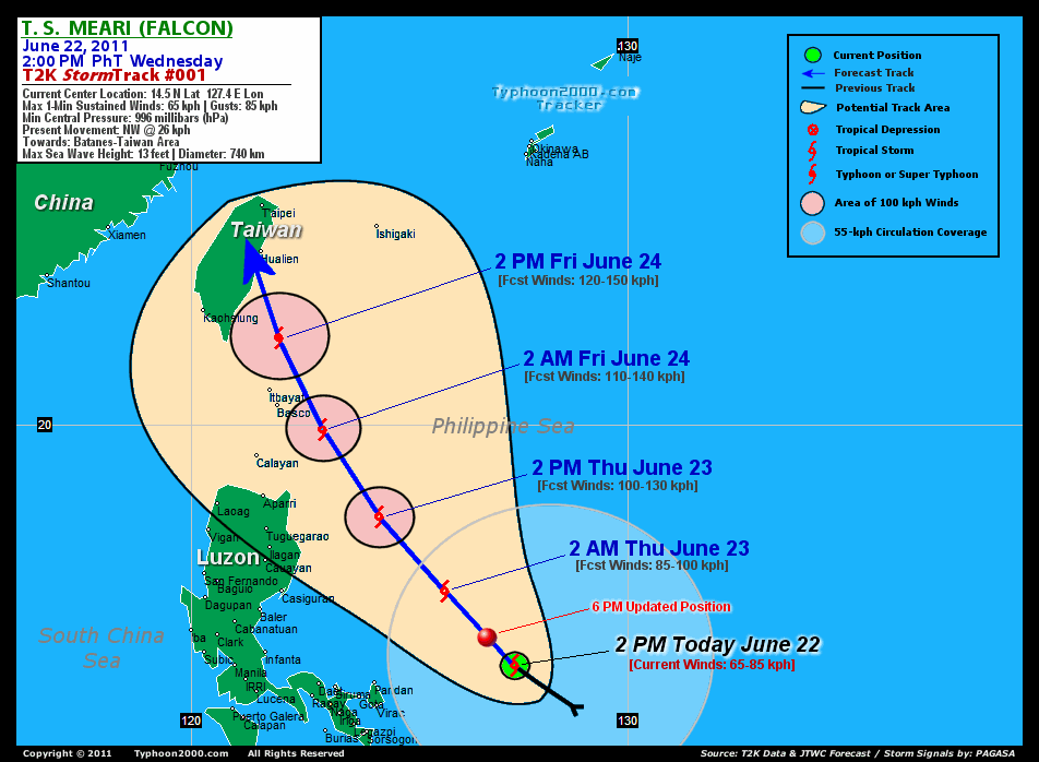
CURRENT STORM INFORMATION
Time/Date: 6:00 PM PhT Wed June 22 2011
Location of Center: 15.0º N Lat 126.9º E Lon
Distance 1: 305 km (165 nm) ENE of Pandan, Catanduanes
Distance 2: 335 km (180 nm) NE of Virac, Catanduanes
Distance 3: 430 km (232 nm) ENE of Metro Naga/CWC
Distance 4: 530 km (287 nm) ESE of Casiguran, Aurora
Distance 5: 560 km (303 nm) East of Infanta, Quezon
Distance 6: 635 km (342 nm) ENE of Metro Manila
MaxWinds (1-min avg): 65 kph (35 kts) near the center
Peak Wind Gusts: 85 kph (45 kts)
Present Movement: NW @ 26 kph (14 kts)
Towards: Batanes-Taiwan
Landfall [ETA] to Taiwan: Sat Early AM [1-2AM HKT]
12-18hr Rainfall Accum (near center): 200 mm (High)
Minimum Central Pressure: 996 millibars (hPa)
Saffir-Simpson Typhoon Scale: Tropical Storm
Size (in Diameter): 740 km (400 nm) / Large
Wind Area Distribution (in Knots): Current Wind Profile
Max Sea Wave Height (near center): 13 ft (3.9 m)
Possible Storm Surge Height: 0 ft [0 m]
T2K TrackMap (for Public): 6:00 PM PhT Wed June 22
FORECAST OUTLOOK ANALYSIS (up to 2 days)* MEARI's (FALCON) CLOSEST POINT OF APPROACH (CPA)* EXTENDED FORECAST TRACK (3 to 5 days)* EFFECTS & HAZARDS SUMMARY CURRENT SW MONSOON INTENSITY: STRONG >> Mostly cloudy with widespread moderate to heavy on-&-off rains w/ squalls & thunderstorms will be expected along the following affected areas: SULU SEA, VISAYAS, MASBATE, NORTHERN PALAWAN & MINDANAO. Light to moderate SW'ly winds (not in excess of 40 kph) will blow.
07W (FALCON) is expected to maintain its NW track across the warm Philippine Sea and will continue to intensify for the next 24-48 hours. MEARI shall reach Typhoon status (Category 1) on Friday afternoon, June 24 prior in making landfall over Eastern Taiwan. Below are the summary of the 2-day forecast for MEARI (FALCON).  TOMORROW EARLY MORNING (THU): Intensifying over the warm waters of the Philippine Sea...about 395 km East of Casiguran, Aurora [2AM JUN 23: 16.2N 125.8E @ 85kph]. TOMORROW AFTERNOON (THU): Passing well to the east of Isabela & Cagayan Provinces (still over the Philippine Sea)...about 280 km ESE of Aparri, Cagayan [2PM JUN 23: 17.9N 124.3E @ 100kph]. FRIDAY EARLY MORNING: Almost a Category 1 Typhoon...passing close to the Batanes Group of Islands...about 125 km ESE of Basco [2AM JUN 24: 19.9N 123.0E @ 110kph]. FRIDAY MORNING: Upgraded to a Typhoon as it moves away from the Batanes Group...approaching the coast of Eastern Taiwan...about 185 km ESE of Kaohsiung City, Taiwan [2PM JUN 24: 22.0N 122.0E @ 120kph].
Maximum Sustained Winds (1-min. avg) are near 65 km/hr (35 knots) with higher gusts. MEARI (FALCON) is a Tropical Storm (TS) on the Saffir-Simpson Tropical Cyclone Scale. Some strengthening expected within the next 12 to 24 hours. BATANES GROUP OF ISLANDS: About 65 km ENE of Basco [ETA: between 6:00-7:00 AM HKT Friday, June 24]. EASTERN TAIWAN: About 25 km WSW of Hualien City [ETA: between 1:00-2:00 AM HKT Saturday, June 25]. SATURDAY AFTERNOON: Downgraded to a severe Tropical Storm (TS) after making landfall over Taiwan...off Taiwan Strait [2PM JUNE 25: 25.9N 120.8E @ 95kph]. SUNDAY AFTERNOON: Near Shanghai, China after making its second landfall off Eastern China...weakens further to a minimal TS [2PM JUNE 26: 30.4N 121.0E @ 75kph]. MONDAY AFTERNOON: Enters the Yellow Sea as it dissipates [2PM JUNE 27: 35.7N 122.8E @ 65kph].
*Please be reminded that the Forecast Outlook changes every 6 hours, and the Extended Forecast Track have an average error of 250 km on Day 3...450 km on Day 4...and 650 km on Day 5, while the wind speed forecast error, averages 35 kph per day. Therefore, a turn to the left or right of its future track and changes in its wind speed must be anticipated from time to time.
MEARI's (FALCON) broad circulation continues to consolidate and strengthen while over the warm Philippine Sea with its western outer rainbands affecting the Bicol Region and Eastern Visayas. Below are the summary of the depression's parts and its hazards affecting specific areas: INNER RAINBANDS - over water (off Central Philippine Sea)...not affecting any land areas. Tropical Storm Conditions w/ Tropical Storm Force Winds (65-85 kph) can be expected along these bands. OUTER RAINBANDS - affecting & spreading along the Bicol Region and Eastern Visayas. Tropical Depression Conditions w/ moderate to strong winds (30-61 kph) can be expected along these bands (click here to know more about Rainbands). 12-18HR TOTAL RAINFALL ACCUMULATION - from 5 up to 50 mm (low to medium rainfall) can be expected along the outer & inner rainbands...with isolated amounts of up to 200 mm (high) near the center of MEARI (FALCON). (click to open NOAA's eTRaP graphic).
Important Note: Please keep in mind that the above forecast outlook, extended forecast, effects-hazards, current monsoon intensity, & tropical cyclone watch changes every 6 to 12 hrs!
JTWC (US NAVY & AIR FORCE) REMARKS:
REMARKS (for Meteorologists): 2 PM (06 GMT) WED 22 JUNE POSITION: 14.5N 127.4E.
*TROPICAL STORM (TS) 07W (SEVEN), LOCATED APPROXIMATELY 370 NM
EAST OF MANILA, PHILIPPINES, HAS TRACKED NORTHWESTWARD AT 14 KTS
OVER THE PAST SIX HOURS. ANIMATED WATER VAPOR IMAGERY SHOWS A VERY
BROAD SYSTEM THAT SPANS ALMOST THE ENTIRE PHILIPPINE SEA. DEEP
CONVECTIVE BANDS ARE BEGINNING TO CONSOLIDATE AROUND TWO POSSIBLE
LOW LEVEL CIRCULATION CENTERS (LLCC). THIS FORECAST IS BASED ON THE
MORE DOMINANT LLCC WITH FORMATIVE BANDS WRAPPING FROM THE NORTH. THE
SECONDARY LLCC IS TO THE SOUTHEAST WITH FORMATIVE BANDS WRAPPING
FROM THE SOUTHWEST. UPPER LEVEL ANALYSIS INDICATES THE SYSTEM IS
UNDER A RIDGE AXIS IN AN AREA OF LOW VERTICAL WIND SHEAR. A TROPICAL
UPPER TROPOSPHERIC TROUGH CELL TO THE EAST IS ENHANCING OUTFLOW. THE
INITIAL POSITION IS EXTRAPOLATED FROM A 220454Z AMSU-B MICROWAVE
IMAGE SHOWING A DISTINCT NOTCH OVER THE LLCC. THE INITIAL INTENSITY
IS SUPPORTED MY DVORAK ESTIMATES FROM PGTW, KNES, AND RJTD AND FROM
A 220138Z ASCAT PASS SHOWING 35-KNOT WIND BARBS AROUND THE LLCC. THE
SYSTEM IS TRACKING ALONG THE SOUTHWEST PERIPHERY OF A DEEP-LAYERED
SUBTROPICAL RIDGE ANCHORED SOUTHEAST OF JAPAN. IT IS EXPECTED TO
CONTINUE TRACKING NORHTWESTWARD UP TO TAU 48 BEFORE CROSSING TAIWAN
THEN MOVE ON A MORE POLEWARD TRACK IN RESPONSE TO A MID-LATITUDE
TROUGH APPROACHING FROM THE NORTHWEST. THE SYSTEM WILL GRADUALLY
INTENSIFY DUE TO THE FAVORABLE UPPER LEVEL CONDITIONS, PEAKING AT
TYPHOON INTENSITY BEFORE TAIWAN. IT WILL THEN CROSS THE EASTERN TIP
OF CHINA AND EXIT INTO THE YELLOW SEA NEAR SHANGHAI AND COMMENCE
DISSIPATION OVER WATER. THE AVAILABLE NUMERICAL GUIDANCE FAN OUT TO
ABOUT A 30-DEGREE SPREAD WITH ECMWF TO THE LEFT OF AND NOGAPS AND
GFDN TO THE RIGHT OF THE MODEL ENVELOPE. THIS TRACK FORECAST IS TO
THE LEFT OF CONSENSUS TO OFFSET THE RIGHT OUTLIERS' UNLIKELY
INCURSION INTO THE STEERING RIDGE...(more info)
>> MEARI, meaning: Reflection of sound or echo. Name contributed by: DPR Korea. [CORRECTED]
_______________________________________________________________________________________________________________________________________
RECENT TYPHOON2000.COM (JTWC) TRACKING CHART:
_________________________________________________________________________________________________________________
RECENT MULTI-AGENCY TROPICAL CYCLONE FORECAST TRACKING CHART: 
_________________________________________________________________________________________________________________

> Image source: NOAA SATELLITE CENTER: http://www.ssd.noaa.gov/mtsat/flt/t1/rgb.jpg
> Image source: Wunderground.com Tropical Page (http://www.wunderground.com/tropical)
____________________________________________________________________________________________________________________
LATEST 12-18 HR. TOTAL RAINFALL AMOUNTS / ENSEMBLE TROPICAL RAINFALL POTENTIAL (eTRaP):

> Image source: NOAA Satellite & Information Service (http://www.ssd.noaa.gov/PS/TROP/etrap.html)
>> To know the meteorological terminologies and acronyms used on this update visit the ff:
http://typhoon2000.ph/tcterm.htm
http://www.nhc.noaa.gov/aboutgloss.shtml
http://www.srh.noaa.gov/oun/severewx/glossary.php
http://www.srh.weather.gov/fwd/glossarynation.html
http://www.nhc.noaa.gov/acronyms.shtml
__________________________________________________________________________________________
For the complete details on TS MEARI (FALCON)...go visit our website @:
> http://www.typhoon2000.com
> http://www.maybagyo.com
Copyright © 2011 Typhoon2000.com All Rights Reserved

No comments:
Post a Comment