
for Sunday, 19 June 2011 [12:50 PM PhT]![]()

<<<Typhoon2000.com Mobile >>>
Get the latest 3-hrly SMS Storm Alerts on EGAY!
For more details: Text T2K HELP to
2800 (Globe/TM) | 216 (Smart/TNT) | 2288 (Sun)
*Only P2.50 (Smart/Globe) / P2.00 (Sun) per msg received.
Click here on how to use this service (in PDF file)
Powered by: Synermaxx Corporation
Typhoon2000 (T2K) NEWS (Saturday June 18 2011):
Currently issuing 3-hrly web, twitter and e-mail updates (except 12:00 Midnight) on TS 06W (EGAY).
06W (EGAY) MAX WIND SPEED PER AGENCY:
+ USA (JTWC/1-min avg): 65 km/hr
+ Japan (JMA/10-min avg): 55 km/hr
+ Philippines (PAGASA/10-min avg): 55 km/hr
TROPICAL STORM 06W [EGAY]
T2K PUBLIC ADVISORY NUMBER 010
12:00 PM PhT (04:00 GMT) Sun 19 June 2011
Sources: T2K Extrap Analysis/JTWC Warning #010/SatFixes
View: Advisory Archives (2004-2011)
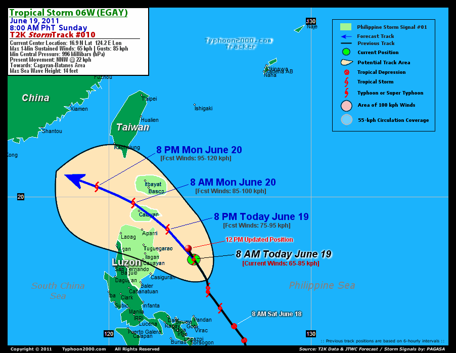
Tropical Storm 06W (EGAY) maintaining its NNW track as it approaches the coastal waters of Cagayan. Enhanced Southwest Monsoon bringing occasional rains across Metro Manila, the western sections of Luzon and Visayas including Bicol Region, Palawan, Mindoro and Southern Tagalog Provinces. Its semi cloud-free center has accelerated northwestward during the past 3 hours.
Residents and visitors along the Eastern Coast of Central & Northern Luzon should closely monitor the progress of 06W (EGAY).
Do not use this for life or death decision. This advisory is intended for additional information purposes only. Kindly refer to your country's official weather agency for local warnings, advisories & bulletins.
CURRENT STORM INFORMATION
Time/Date: 12:00 PM PhT Sun June 19 2011
Location of Center: 17.4º N Lat 123.9º E Lon
Distance 1: 225 km (123 nm) ENE of Ilagan City
Distance 2: 235 km (127 nm) East of Tuguegarao City
Distance 3: 235 km (127 nm) NE of Casiguran, Aurora
Distance 4: 240 km (130 nm) ENE of Cauayan, Isabela
Distance 5: 260 km (140 nm) SE of Aparri, Cagayan
Distance 6: 330 km (178 nm) SE of Calayan Island
Distance 7: 400 km (215 nm) SSE of Basco, Batanes
Distance 8: 440 km (238 nm) NE of Metro Manila
MaxWinds (1-min avg): 65 kph (35 kts) near the center
Peak Wind Gusts: 85 kph (45 kts)
Present Movement: NNW @ 22 kph (12 kts)
Towards: Cagayan-Batanes Area
Landfall [ETA] to N.Cagayan: Tonight [8-11PM PhT]
06-12hr Rainfall Accum (near center): 70 mm (Med)
Rainrate (near center): 20-25 mm/hr (Mod)
Minimum Central Pressure: 996 millibars (hPa)
Saffir-Simpson Typhoon Scale: TS
Size (in Diameter): --- km (--- nm) / N/A
Wind Area Distribution (in Knots): Current Wind Profile
Max Sea Wave Height (near center): 13 ft (3.9 m)
Possible Storm Surge Height: 0 ft [0 m]
T2K TrackMap (for Public): 12:00 PM PhT Sun June 19
FORECAST OUTLOOK ANALYSIS (up to 2 days)* 06W's CLOSEST POINT OF APPROACH (CPA)* EXTENDED FORECAST TRACK (3 to 4 days)* EFFECTS & HAZARDS SUMMARY TROPICAL CYCLONE WATCH CURRENT SW MONSOON INTENSITY: STRONG >> Mostly cloudy with widespread moderate to heavy on-&-off rains w/ squalls & thunderstorms will be expected along the following affected areas: SULU SEA, WESTERN VISAYAS, PALAWAN, CALAMIAN GROUP, BICOL incl. MASBATE, METRO MANILA, SOUTHERN TAGALOG PROVINCES, SW LUZON, & MINDORO. Light to moderate SW'ly winds (not in excess of 40 kph) will blow. Important Note: Please keep in mind that the above forecast outlook, extended forecast, effects-hazards, current monsoon intensity, & tropical cyclone watch changes every 6 to 12 hrs! PHILIPPINE STORM WARNING SIGNAL # ONE (1) The above areas will have rains and winds of not more than 60 kph today. Coastal waters will be moderate to rough.
06W (EGAY) is expected to intensify slowly as it turns more NW to WNW within the next 24-48 hours, passing close to the north of Cagayan early tomorrow morning - passing along the Calayan Island in the Balintang Channel, before moving out into the South China Sea tomorrow afternoon through the evening.  THIS EVENING (SUN): Intensifying as it nears the coastal areas of Northern Cagayan...about 75 km East of Escaparda Point, Cagayan, PH [8PM JUN 19: 18.4N 122.9E @ 75kph]. TOMORROW MORNING (MON): Moving into the South China Sea, after traversing the Balintang Channel...still intensifying...about 55 km NW of Calayan Island, Cagayan, PH [8AM JUN 20: 19.7N 121.2E @ 85kph]. TOMORROW EVENING (MON): Entering the Northern part of the South China Sea...strengthens to a Severe Tropical Storm...about 260 km West of Basco, Batanes, PH [8PM JUN 20: 20.5N 119.4E @ 95kph]. TUESDAY MORNING: Maintains strength as it approaches the coast of Southern China...about 260 km SSE of Shantou City, Fujian, China [8AM JUN 21: 21.4N 118.0E @ 95kph].
Maximum Sustained Winds (1-min. avg) are near 65 km/hr (35 knots) with higher gusts. Tropical Storm Force Winds (62-85 km/hr) extend outward up to 100 kilometers (55 nautical miles) from the center. 06W (EGAY) is a Tropical Storm (TS) on the Saffir-Simpson Tropical Cyclone Scale. NORTHERN CAGAYAN: About 90 km ENE of Aparri, Cagayan or 40 km NNE of Escaparda Point [ETA: between 10:00-11:00 PM Tonight]. WEDNESDAY MORNING: Making landfall over Southern China...starts dissipating [8AM JUNE 22: 23.0N 116.3E @ 85kph]. THURSDAY MORNING: Dissipating over mainland China as an area of low pressure [8AM JUNE 23: 24.7N 115.0E @ 35kph].
*Please be reminded that the Forecast Outlook changes every 6 hours, and the Extended Forecast Track have an average error of 250 km on Day 3...450 km on Day 4...and 650 km on Day 5, while the wind speed forecast error, averages 35 kph per day. Therefore, a turn to the left or right of its future track and changes in its wind speed must be anticipated from time to time.
06W's (EGAY) circulation still sheared with the low-level circulation center (LLCC) not aligned with the rain-cloud convection. Below are the summary of the depression's parts and its hazards affecting specific areas: DEVELOPING INNER RAINBANDS - still over water (Philippine Sea)...not affecting any land areas. Tropical Storm Conditions w/ Tropical Storm Force Winds (65-85 kph) can be expected along these bands. OUTER RAINBANDS - affecting & spreading across Ilocos Norte, Cagayan, Isabela, Aurora, Quezon, Quirino, Ifugao, Nueva Vizcaya, Mt. Province, & Polillo Islands. Tropical Depression Conditions w/ moderate to strong winds (30-61 kph) can be expected along these bands (click here to know more about Rainbands). 06-12HR TOTAL RAINFALL ACCUMULATION - from 5 up to 25 mm (low rainfall) can be expected along the outer & inner rainbands...with isolated amounts of up to 70 mm (medium) near the center of 06W (EGAY). (click to open NOAA's eTRaP graphic).
The new Tropical Disturbance 99W (LPA/1008 MB) remains over the Caroline Islands, SW of Guam with little change in organization. Its possible center was located near lat 7.5N lon 141.6E...about 1665 km East of Mindanao, PH...with 1-min maximum sustained winds of 30 kph near the center...drifting WNW slowly. The 24-Hr. Tropical Cyclone Formation Potential on this system remains @ 20% [Low]. View the latest satellite flash loop on this disturbance. ![]()
PAGASA Philippine Storm Warnings Signals

In Effect: AURORA, CAGAYAN, ISABELA, QUIRINO, NUEVA VIZCAYA, CALAYAN-BABUYAN IS., IFUGAO, MT. PROVINCE, KALINGA, ABRA, APAYAO & ILOCOS NORTE.
Residents living in low-lying and mountainous areas under Public Storm Warning Signal Number 1 are alerted against flashfloods, mudslides and landslides.
JTWC (US NAVY & AIR FORCE) REMARKS:
REMARKS (for Meteorologists): 8 AM (00 GMT) SUN 19 JUNE POSITION: 16.9N 124.2E.
*TROPICAL STORM 06W (SIX), LOCATED APPROXIMATELY 230 NM
NORTHEAST OF MANILA, PHILIPPINES, HAS TRACKED NORTH-NORTHWESTWARD
AT 12 KNOTS OVER THE PAST SIX HOURS. THE CURRENT POSITION IS BASED
ON RECENT MICROWAVE AND VISIBLE SATELLITE IMAGERY OF A PARTIALLY
EXPOSED LOW LEVEL CIRCULATION CENTER (LLCC). THE CURRENT INTENSITY
ESTIMATE OF 35 KNOTS IS CONSISTENT WITH DVORAK T-NUMBERS OF 2.5
FROM PGTW AND KNES. TS 06W CONTINUES TO TRACK GENERALLY NORTHWEST-
WARD ALONG THE SOUTHWESTERN PERIPHERY OF A SUBTROPICAL STEERING
RIDGE TO THE NORTHEAST. MODERATE EASTERLY VERTICAL WIND SHEAR AND
CONVERGENCE IN THE UPPER LEVEL FLOW TO THE NORTH OF TS 06W HAVE
PREVENTED THE SYSTEM FROM INTENSIFYING OVER THE PAST TWELVE HOURS
DESPITE PASSAGE OVER VERY WARM WATER EAST OF LUZON AND STRONG
WESTWARD OUTFLOW ALOFT. THE PERSISTENT VERTICAL WIND SHEAR HAS
CONFINED THE DEEPEST CONVECTION ASSOCIATED WITH TS 06W TO THE
WESTERN PERIPHERY OF THE CIRCULATION...(more)
_______________________________________________________________________________________________________________________________________
RECENT TYPHOON2000.COM TRACKING CHART:
_________________________________________________________________________________________________________________
RECENT MULTI-AGENCY TROPICAL CYCLONE FORECAST TRACKING CHART:
**N/A**

> Image source: NOAA SATELLITE CENTER: http://www.ssd.noaa.gov/mtsat/flt/t1/rgb.jpg
> Image source: Wunderground.com Tropical Page (http://www.wunderground.com/tropical)
____________________________________________________________________________________________________________________
LATEST 06-12 HR. TOTAL RAINFALL AMOUNTS / ENSEMBLE TROPICAL RAINFALL POTENTIAL (eTRaP):

> Image source: NOAA Satellite & Information Service (http://www.ssd.noaa.gov/PS/TROP/etrap.html)
>> To know the meteorological terminologies and acronyms used on this update visit the ff:
http://typhoon2000.ph/tcterm.htm
http://www.nhc.noaa.gov/aboutgloss.shtml
http://www.srh.noaa.gov/oun/severewx/glossary.php
http://www.srh.weather.gov/fwd/glossarynation.html
http://www.nhc.noaa.gov/acronyms.shtml
__________________________________________________________________________________________
For the complete details on TS 06W (EGAY)...go visit our website @:
> http://www.typhoon2000.com
> http://www.maybagyo.com
Copyright © 2011 Typhoon2000.com All Rights Reserved

No comments:
Post a Comment