
for Saturday, 18 June 2011 [6:30 AM PhT]![]()

<<<Typhoon2000.com Mobile >>>
Get the latest 3-hrly SMS Storm Alerts on EGAY!
For more details: Text T2K HELP to
2800 (Globe/TM) | 216 (Smart/TNT) | 2288 (Sun)
*Only P2.50 (Smart/Globe) / P2.00 (Sun) per msg received.
Click here on how to use this service (in PDF file)
Powered by: Synermaxx Corporation
Typhoon2000 (T2K) NEWS (Saturday June 18 2011):
Currently issuing 3-hrly web, twitter and e-mail updates (except 12:00 Midnight) on the newly-formed TD 06W (EGAY).
06W (EGAY) MAX WIND SPEED PER AGENCY:
+ USA (JTWC/1-min avg): 55 km/hr
+ Japan (JMA/10-min avg): 55 km/hr
+ Philippines (PAGASA/10-min avg): 55 km/hr
TROPICAL DEPRESSION 06W [EGAY]
T2K PUBLIC ADVISORY NUMBER 005
6:00 AM PhT (22:00 GMT) Sat 18 June 2011
Sources: T2K Extrap Analysis/JTWC Warning #005/SatFixes
View: Advisory Archives (2004-2011)
Tropical Depression 06W (EGAY) gained strength as it nears Tropical Storm status...approaching the coastal waters of the Bicol Region, particularly Catanduanes. Winds and rains associated with its rainbands are now affecting the Bicol and Samar Provinces. Enhanced Southwest Monsoon bringing rains across the whole of Visayas & Palawan.
Residents and visitors along the Eastern Coast of Luzon & Visayas including Bicol Region & Polillo should closely monitor the progress of 06W (EGAY).
Do not use this for life or death decision. This advisory is intended for additional information purposes only. Kindly refer to your country's official weather agency for local warnings, advisories & bulletins.
CURRENT STORM INFORMATION
Time/Date: 6:00 AM PhT Sat June 18 2011
Location of Center: 13.3º N Lat 126.2º E Lon
Distance 1: 195 km (105 nm) ENE of Catarman, N.Samar
Distance 2: 215 km (115 nm) ESE of Virac, Catanduanes
Distance 3: 235 km (127 nm) ESE of Pandan, Catanduanes
Distance 4: 240 km (130 nm) ENE of Sorsogon City
Distance 5: 270 km (145 nm) East of Legazpi City
Distance 6: 325 km (175 nm) ESE of Metro Naga/CWC
Distance 7: 365 km (197 nm) ESE of Daet, CamNorte
Distance 8: 580 km (315 nm) ESE of Metro Manila
MaxWinds (1-min avg): 55 kph (30 kts) near the center
Peak Wind Gusts: 75 kph (40 kts)
Present Movement: NW @ 22 kph (12 kts)
Towards: Bicol's East Coast
CPA [ETA] to Bicol: Today [8AM-8PM PhT]
24hr Rainfall Accum (near center): 350 mm (High)
Minimum Central Pressure: 1000 millibars (hPa)
Saffir-Simpson Typhoon Scale: TD
Size (in Diameter): --- km (--- nm) / N/A
Wind Area Distribution (in Knots): Current Wind Profile
Max Sea Wave Height (near center): 10 ft (3.0 m)
Possible Storm Surge Height: 0 ft [0 m]
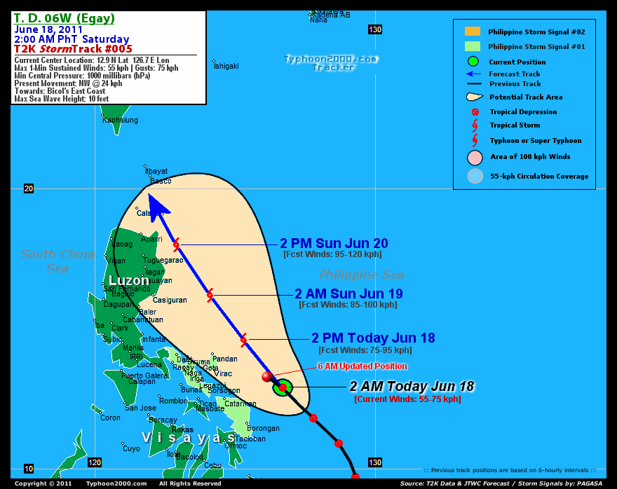
T2K TrackMap (for Public): 6:00 AM PhT Sat June 18
FORECAST OUTLOOK ANALYSIS (up to 2 days)* 06W's CLOSEST POINT OF APPROACH (CPA)* EXTENDED FORECAST TRACK (3 to 5 days)* EFFECTS & HAZARDS SUMMARY Important Note: Please keep in mind that the above forecast outlook, extended forecast, effects-hazards, current monsoon intensity, & tropical cyclone watch changes every 6 to 12 hrs! PHILIPPINE STORM WARNING SIGNAL # ONE (1) The above areas will have rains and winds of not more than 60 kph today. Coastal waters will be moderate to rough.
06W (EGAY) is now expected to steadily intensify, becoming a tropical storm later today...maintaining its NW to NNW track within the next 48 hours, passing to the NE of Bicol Region this afternoon. This system shall pass very close to the NE Coast of Cagayan by tomorrow afternoon (Sunday) before sunset. THIS AFTERNOON (SAT): Attaining Tropical Storm strength while passing close to Catanduanes Island...about 130 km ENE of Pandan, Catanduanes, PH [2PM JUN 18: 14.6N 125.3E @ 75kph]. TOMORROW EARLY MORNING (SUN): Passing well to the east of Aurora Province...still intensifying...about 215 km East of Casiguran, Aurora, PH [2AM JUN 19: 16.2N 124.1E @ 85kph]. TOMORROW AFTERNOON (SUN): Now off the coast of Cagayan, intensifies further...about 145 km ESE of Aparri, Cagayan, PH [2PM JUN 19: 18.0N 122.9E @ 95kph]. MONDAY EARLY MORNING: Upgraded to a Severe Tropical Storm as it traverses the Balintang Channel...about 75 km SW of Basco, Batanes, PH [2AM JUN 20: 20.0N 121.5E @ 100kph].
Maximum Sustained Winds (1-min. avg) are near 55 km/hr (30 knots) with higher gusts. 06W (EGAY) is a Tropical Depression (TD) on the Saffir-Simpson Tropical Cyclone Scale. CATANDUANES: about 130 km ENE of Pandan or 165 km NE of Virac [ETA: between 8:00 AM-2:00 PM Today]. CAGAYAN: about 90 km ENE of Aparri or 25 km ENE of Escaparda Point [ETA: between 2:00 PM-8:00 PM Tomorrow]. TUESDAY EARLY MORNING: Starts to weaken as it moves along the Bashi Channel, just to the SW of Taiwan [2AM JUNE 21: 21.7N 119.3E @ 95kph]. WEDNESDAY EARLY MORNING: Off the coast of Fujian Province, China...prepares to make landfall...continues losing strength [2AM JUNE 22: 23.0N 117.6E @ 85kph]. THURSDAY EARLY MORNING: Over Fujian Province...downgraded to a Tropical Depression (TD) after making landfall [2AM JUNE 23: 24.7N 116.6E @ 55kph].
*Please be reminded that the Forecast Outlook changes every 6 hours, and the Extended Forecast Track have an average error of 250 km on Day 3...450 km on Day 4...and 650 km on Day 5, while the wind speed forecast error, averages 35 kph per day. Therefore, a turn to the left or right of its future track and changes in its wind speed must be anticipated from time to time.
06W's (EGAY) circulation becoming better organized w/ most of its rain-cloud convection displaced West & NW of its low-level center. Below are the summary of the depression's parts and its hazards affecting specific areas: RAINBANDS - affecting & spreading across Bicol Region, Samar Island, Masbate, and portion of Leyte Island. Tropical Depression Conditions w/ moderate to strong winds (30-61 kph) can be expected along these bands (click here to know more about Rainbands). 24HR TOTAL RAINFALL ACCUMULATION - from 5 up to 150 mm (low to medium rainfall) can be expected along the outer & inner rainbands...with isolated amounts of up to 350 mm (high) near the center of 06W (EGAY). (click to open NOAA's eTRaP graphic). ![]()
PAGASA Philippine Storm Warnings Signals

In Effect: CAMARINES SUR, CAMARINES NORTE, ALBAY, CATANDUANES, SORSOGON & SAMAR PROVINCES.
Residents living in low-lying and mountainous areas under Public Storm Warning Signal Number 1 are alerted against flashfloods, mudslides and landslides.
JTWC (US NAVY & AIR FORCE) REMARKS:
REMARKS (for Meteorologists): 2 AM (18 GMT) SAT 18 JUNE POSITION: 12.9N 126.7E.
*TROPICAL DEPRESSION (TD) 06W (SIX), LOCATED APPROXIMATELY 350 NM
EAST-SOUTHEAST OF MANILA, PHILIPPINES, HAS TRACKED NORTHWESTWARD
AT 13 KNOTS OVER THE PAST SIX HOURS. THE CURRENT POSITION IS BASED
ON A 171738Z AMSR-E PASS SHOWING A PARTIALLY EXPOSED LOW LEVEL
CIRCULATION CENTER (LLCC) WITH DEEP CONVECTION CONFINED TO THE
WESTERN PERIPHERY. THE CURRENT INTENSITY ESTIMATE OF 30 KNOTS IS
CONSISTENT WITH A 171730Z PGTW DVORAK T-NUMBER ESTIMATE OF 2.0. TD
06W CONTINUES TO TRACK NORTHWESTWARD ALONG THE SOUTHWESTERN
PERIPHERY OF A SUBTROPICAL STEERING RIDGE TO THE NORTHEAST. THIS
MOTION IS EXPECTED TO CONTINUE FOR THE NEXT 48 HOURS. A DEVELOPING
MID-LATITUDE TROUGH WILL WEAKEN THE STEERING RIDGE BETWEEN TAU 36
AND TAU 72, BUT NOT ENOUGH TO SIGNIFICANTLY IMPACT THE TRACK OF TD
06W. HOWEVER, POLEWARD OUTFLOW TOWARD THE BASE OF THE TROUGH MAY BE
ENHANCED DURING THAT PERIOD, ALLOWING TD 06W TO CONTINUE A SLOW BUT
STEADY INTENSIFICATION TREND DRIVEN BY PASSAGE OVER VERY WARM WATER
AND FAVORABLE WESTWARD OUTFLOW ALOFT. EASTERLY VERTICAL WIND SHEAR
HAS LIMITED AND SHOULD CONTINUE TO LIMIT THE INTENSITIFICATION RATE
DESPITE THE FAVORABLE INFLUENCES OF STRONG WESTWARD OUTFLOW AND HIGH
ALONG TRACK OCEAN HEAT CONTENT. IN THE EXTENDED RANGE, LOWER OCEAN
HEAT CONTENT, RESTRICTED OUTFLOW ALOFT, AND PASSAGE OVER LAND ARE
EXPECTED TO WEAKEN THE CYCLONE. THE NUMERICAL MODELS ARE IN FAIR
AGREEMENT WITH THE CURRENT TRACK FORECAST, WITH NOGAPS DEPICTING
IMMEDIATE POLEWARD MOTION AND ECMWF WESTWARD MOTION AFTER TAU 48.
THE NOGAPS SCENARIO APPEARS VERY UNLIKELY GIVEN CURRENT OBSERVATIONS
DEPICTING A CONTINUOUS RIDGE TO THE NORTH AND NO MECHANISM TO
INTRODUCE A WEAKNESS TO THE RIDGE SO QUICKLY. THE ECMWF KEEPS TD 06W
WEAK THROUGHOUT ITS LIFECYLE, STEERING THE SYSTEM WESTWARD IN THE
EXTENDED PERIOD WITH LOWER LEVEL FLOW. THIS FORECAST FAVORS THE MAIN
MODEL GROUPING CLUSTERED AROUND THE CONSENSUS, WHICH IS MORE
CONSISTENT WITH CURRENT SYNOPTIC REASONING AND THE INTENSITY
FORECAST. THE FORECAST TRACK SPEEDS HAVE INCREASED FROM THE PREVIOUS
WARNING DUE TO A STRONGER THAN PREVIOUSLY ANTICIPATED STEERING FLOW...(more)
_______________________________________________________________________________________________________________________________________
RECENT TYPHOON2000.COM TRACKING CHART:
_________________________________________________________________________________________________________________
RECENT MULTI-AGENCY TROPICAL CYCLONE FORECAST TRACKING CHART:
**N/A**

> Image source: NOAA SATELLITE CENTER: http://www.ssd.noaa.gov/mtsat/flt/t1/rgb.jpg
> Image source: Wunderground.com Tropical Page (http://www.wunderground.com/tropical)
____________________________________________________________________________________________________________________
LATEST 24 HR. TOTAL RAINFALL AMOUNTS / ENSEMBLE TROPICAL RAINFALL POTENTIAL (eTRaP):

> Image source: NOAA Satellite & Information Service (http://www.ssd.noaa.gov/PS/TROP/etrap.html)
>> To know the meteorological terminologies and acronyms used on this update visit the ff:
http://typhoon2000.ph/tcterm.htm
http://www.nhc.noaa.gov/aboutgloss.shtml
http://www.srh.noaa.gov/oun/severewx/glossary.php
http://www.srh.weather.gov/fwd/glossarynation.html
http://www.nhc.noaa.gov/acronyms.shtml
__________________________________________________________________________________________
For the complete details on TD 06W (EGAY)...go visit our website @:
> http://www.typhoon2000.com
> http://www.maybagyo.com
Copyright © 2011 Typhoon2000.com All Rights Reserved

No comments:
Post a Comment