
for Thursday, 23 June 2011 [6:30 PM PhT]![]()

<<<Typhoon2000.com Mobile >>>
Get the latest 6-hrly SMS Storm Alerts on FALCON!
For more details: Text T2K TYPHOON to
2800 (Globe/TM) | 216 (Smart/TNT) | 2288 (Sun)
*Only P2.50 (Smart/Globe) / P2.00 (Sun) per msg received.
Click here on how to use this service (in PDF file)
Powered by: Synermaxx Corporation
Typhoon2000 (T2K) NEWS (Wednesday June 22 2011):
Currently issuing 6-hrly web, SMS, Twitter and e-mail updates (except 12:00 Midnight) on TS MEARI (FALCON).
MEARI (FALCON) MAX WIND SPEED PER AGENCY:
+ USA (JTWC/1-min avg): 75 km/hr
+ Japan (JMA/10-min avg): 75 km/hr
+ Philippines (PAGASA/10-min avg): 75 km/hr
+ Korea (KMA/10-min avg): 85 km/hr
+ Taiwan (CWB/10-min avg): 65 km/hr
+ Beijing (NMC/2-min avg): 65 km/hr
+ Hong Kong (HKO/10-min avg): 65 km/hr
:: Click here to see Multi-Agency Forecast Tracks
TROPICAL STORM MEARI [FALCON/07W/1105]
T2K PUBLIC ADVISORY NUMBER 012
6:00 PM PhT (10:00 GMT) Thu 23 June 2011
Sources: T2K Extrap Analysis/JTWC Warning #007/SatFixes
View: Advisory Archives (2004-2011)
The very large Tropical Storm MEARI (FALCON) has started to accelerate NNW, pulling behind a large swath of monsoon rains & winds across the Philippines. This monsoon weather will likely to persist until Saturday or Sunday.
Residents and visitors along Extreme Northern Luzon, Batanes-Calayan-Babuyan Islands, Yaeyama-Okinawa-Ryukyu Islands, & Taiwan should closely monitor the progress of MEARI (FALCON).
Do not use this for life or death decision. This advisory is intended for additional information purposes only. Kindly refer to your country's official weather agency for local warnings, advisories & bulletins.
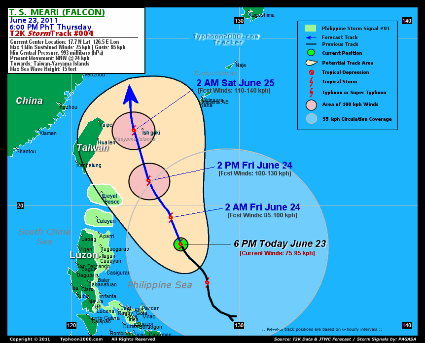
CURRENT STORM INFORMATION
Time/Date: 6:00 PM PhT Thu June 23 2011
Location of Center: 17.7º N Lat 126.5º E Lon
Distance 1: 510 km (275 nm) East of Tuguegarao City
Distance 2: 500 km (270 nm) ENE of Ilagan City
Distance 3: 525 km (285 nm) ESE of Aparri, Cagayan
Distance 4: 560 km (302 nm) SE of Basco, Batanes
Distance 5: 575 km (310 nm) NNE of Metro Naga/CWC
Distance 6: 680 km (367 nm) NE of Metro Manila
MaxWinds (1-min avg): 75 kph (40 kts) near the center
Peak Wind Gusts: 95 kph (50 kts)
Present Movement: NNW @ 24 kph (13 kts)
Towards: Taiwan-Yaeyama Area
CPA [ETA] to Taiwan: Sat Morning [5-6AM HKT]
24hr Rainfall Accum (near center): 380 mm (High)
Rainrate (near center): 20-30 mm/hr (Mod)
Minimum Central Pressure: 993 millibars (hPa)
Saffir-Simpson Typhoon Scale: Tropical Storm
Size (in Diameter): 1,205 km (650 nm) / Very Large
Wind Area Distribution (in Knots): Current Wind Profile
Max Sea Wave Height (near center): 15 ft (4.5 m)
Possible Storm Surge Height: 0 ft [0 m]
T2K TrackMap (for Public): 6:00 PM PhT Thu June 23
FORECAST OUTLOOK ANALYSIS (up to 2 days)* MEARI's (FALCON) CLOSEST POINT OF APPROACH (CPA)* EXTENDED FORECAST TRACK (3 to 4 days)* EFFECTS & HAZARDS SUMMARY CURRENT SW MONSOON INTENSITY: STRONG >> Mostly cloudy with widespread moderate to heavy on-&-off rains w/ squalls & thunderstorms will be expected along the following affected areas: REST OF LUZON, METRO MANILA, MINDORO, MARINDUQUE, ROMBLON, SULU SEA, VISAYAS, MASBATE,BICOL REGION, PALAWAN & MINDANAO. Moderate to strong SW'ly winds (not in excess of 65 kph) will blow.
MEARI (FALCON) is expected to continue accelerating NNW-ward across the warm Philippine Sea and will intensify for the next 24-48 hours. MEARI shall reach Typhoon status (Category 1) by Saturday, upon exiting the Philippine Area of Responsibility (PAR) or off the East China Sea. Below are the summary of the 2-day forecast for MEARI (FALCON).  TOMORROW EARLY MORNING (FRI): Intensifying over the warm waters of the Philippine Sea as it tracks NNW...about 460 km East of Calayan Island, Cagayan [2AM JUN 24: 19.3N 125.9E @ 85kph]. TOMORROW AFTERNOON (FRI): Continues to intensify while passing well to the ENE of the Batanes Group of Islands (still over the Philippine Sea)...about 290 km ENE of Basco, Batanes [2PM JUN 24: 21.5N 124.6E @ 100kph]. SATURDAY EARLY MORNING: Almost a Typhoon...passing to the east of Taiwan or very near Ishigakijima off the Yaeyama Island Chain...about 220 km ESE of Taipei, Taiwan [2AM JUN 25: 24.5N 123.7E @ 110kph]. SATURDAY AFTERNOON: Becomes a Category 1 Typhoon while off the South China Sea, just to the east of Eastern China...turns more poleward (north)...about 265 km ESE of Wenzhou City, China [2PM JUN 25: 27.4N 123.3E @ 120kph].
Maximum Sustained Winds (1-min. avg) are near 75 km/hr (40 knots) with higher gusts. MEARI (FALCON) is a Tropical Storm (TS) on the Saffir-Simpson Tropical Cyclone Scale. Some strengthening can be expected within the next 12 to 24 hours. Tropical Storm Force Winds (62-95 km/hr) extend outward up to 215 kilometers (115 nautical miles) from the center. MEARI is a very large-sized tropical cyclone with a diameter of 1,205 kilometers (650 nautical miles). YAEYAMA GROUP OF ISLANDS: About 50 km west of Ishigakijima [ETA: between 1:00-2:00 AM HKT Saturday, June 25]. EASTERN TAIWAN: About 205 km East of Taipei [ETA: between 5:00-6:00 AM HKT Saturday, June 25]. SUNDAY AFTERNOON: Downgraded to a Tropical Storm (TS) as it begins transforming into an Extratropical Cyclone...moving faster across the Yellow Sea [2PM JUNE 26: 34.0N 124.1E @ 85kph]. MONDAY AFTERNOON: Becomes an Extratropical Cyclone as it makes landfall over North Korea [2PM JUNE 27: 39.7N 127.0E @ 45kph].
*Please be reminded that the Forecast Outlook changes every 6 hours, and the Extended Forecast Track have an average error of 250 km on Day 3...450 km on Day 4...and 650 km on Day 5, while the wind speed forecast error, averages 35 kph per day. Therefore, a turn to the left or right of its future track and changes in its wind speed must be anticipated from time to time.
MEARI's (FALCON) very large circulation continues to consolidate and strengthen slowly while over the warm Philippine Sea with its southwestern & western outer rainbands affecting the Bicol Region and Eastern Luzon. Below are the summary of the depression's parts and its hazards affecting specific areas: INNER RAINBANDS - over water (off North-Central Philippine Sea)...not affecting any land areas. Tropical Storm Conditions w/ Tropical Storm Force Winds (62-95 kph) can be expected along these bands. OUTER RAINBANDS - affecting & spreading along the Bicol Region, Quezon Provinces, Aurora, Cagayan, and the Batanes-Babuyan-Calayan Islands. Tropical Depression Conditions w/ moderate to strong winds (30-61 kph) can be expected along these bands (click here to know more about Rainbands). 24HR TOTAL RAINFALL ACCUMULATION - from 5 up to 75 mm (low to medium rainfall) can be expected along the outer & inner rainbands...with isolated amounts of up to 280 mm (high) along MEARI's (FALCON) eastern and western circulations (near Eastern Luzon). (click to open NOAA's eTRaP graphic).
Important Note: Please keep in mind that the above forecast outlook, extended forecast, effects-hazards, current monsoon intensity, & tropical cyclone watch changes every 6 to 12 hrs!![]()
PAGASA Philippine Storm Warnings Signals
PHILIPPINE STORM WARNING SIGNAL # ONE (1) 
In Effect: QUEZON, AURORA, ALBAY, CATANDUANES, CAMARINES SUR, CAMARINES NORTE, ISABELA, CAGAYAN, & THE CALAYAN-BABUYAN-BATANES GROUP OF ISLANDS.
The above areas will have rains and winds of not more than 60 kph tonight and tomorrow. Coastal waters will be moderate to rough.
Residents living in low-lying and mountainous areas under Public Storm Warning Signal Number 1 are alerted against flashfloods, mudslides and landslides.
JTWC (US NAVY & AIR FORCE) REMARKS:
REMARKS (for Meteorologists): 2 PM (06 GMT) THU 23 JUNE POSITION: 17.1N 126.8E.
*TROPICAL STORM (TS) 07W (MEARI), LOCATED APPROXIMATELY 550 NM
SOUTH OF KADENA AIR BASE, JAPAN, HAS TRACKED NORTHWESTWARD AT
13 KNOTS OVER THE PAST SIX HOURS. THE LOW LEVEL CIRCULATION (LLCC)
IS EXPOSED AND ELONGATED, WITH BANDS OF VIGOROUS CONVECTION DISPLACED
TO EITHER SIDE OF THE CENTER. ANIMATED MSI SHOWS SEVERAL SMALL-SCALE
VORTICES ROTATING AROUND AND THEN MERGING WITH THE LLCC. THE
RELATIVELY CLEAR AIR NEAR THE CENTER OF THE SYSTEM AND THE CYCLING
MINOR VORTICES GIVES THE SYSTEM A MONSOON DEPRESSION SIGNATURE. A
230114Z PARTIAL ASCAT PASS SHOWS A WIDE SWATH OF 30 TO 40 KNOT WINDS
OVER THE EASTERN SEMI-CIRCLE. THE CURRENT INTENSITY ANALYSIS OF 40
KNOTS IS BASED PRIMARILY ON THE ASCAT PASS, AS THE LACK OF CORE
CONVECTION IS MAKING DVORAK ESTIMATES LESS RELIABLE. AGENCY DVORAK
ESTIMATES ARE, HOWEVER, CONSISTENT WITH THE REMOTE SENSING DATA. TS
07W IS TRACKING AROUND THE SOUTHWESTERN FLANK OF THE SUB-TROPICAL
RIDGE, WHICH IS CURRENTLY CENTERED NEAR 28N 145E. RECENT UPPER LEVEL
STREAMLINE ANALYSES SHOW A COMPLEX UPPER LEVEL PATTERN WITH A BROAD
NORTH-SOUTH ORIENTED WEAKNESS ALONG THE 130TH LONGITUDE. THIS IS
ALLOWING TROPICAL STORM MEARI TO TAKE A POLEWARD TRACK. WATER VAPOR
ANIMATION SHOWS AN UPPER LEVEL LOW DIVING SOUTHWARD FROM THE YELLOW
SEA TOWARD THE NORTHERN RYUKUS. THIS LOW IS NOT REFLECTING ON THE
500 MB ANALYSIS, INDICATING IT IS CONFINED TO THE UPPER TROPOSPHERE
AND WILL BE A SHEARING FORCE BUT HAVE LITTLE EFFECT ON STEERING.
THE BONIN HIGH WILL REMAIN THE STEERING INFLUENCE THROUGH THE NEXT
72 HOURS. THE UPPER LOW AND THE TROPICAL UPPER TROPOSPHERE TROUGH
(TUTT) TO THE NORTHEAST OF THE SYSTEM ARE INHIBITING POLEWARD
OUTFLOW. EQUATORWARD OUTFLOW REMAINS VIGOROUS. AS TS 07W MOVES
POLEWARD, IT WILL ENCOUNTER INCREASING VERTICAL WIND SHEAR AND
SUBSIDENCE ALOFT, BUT SIMULTANEOUSLY, A POLEWARD OUTFLOW CHANNEL
INTO THE UPPER LEVEL LOW WILL LIKELY DEVELOP. TS 07W WILL INTENSIFY
AT A LESS-THAN-CLIMATOLOGICAL RATE UNDER THESE COMPETING INFLUENCES
AS IT TRACKS WEST OF THE RYUKUS. A SHARP DROP IN SEA SURFACE
TEMPERATURES WILL OCCUR BEFORE THE 30TH LATITUDE AND TS 07W WILL
WEAKEN RAPIDLY WHILE TRACKING INTO THE YELLOW SEA. MODEL GUIDANCE IS
IN GOOD AGREEMENT ON BOTH TRACK AND INTENSITY FORECAST OVER THE
MEDIUM TERM, BUT THERE IS WIDE DISPARITY IN HOW THEY HANDLE THE
TRANSITION TO THE MID-LATITUDES AFTER TAU 72. NOGAPS IS THE EASTWARD
OUTLIER IN THE NEAR TO MEDIUM TERM, HENCE THE JTWC FORECAST STAYS
WEST OF CONSENSUS THROUGH THE FIRST 72 HOURS...(more info)
>> MEARI, meaning: Reflection of sound or echo. Name contributed by: DPR Korea.
_______________________________________________________________________________________________________________________________________
RECENT TYPHOON2000.COM (JTWC) TRACKING CHART:
_________________________________________________________________________________________________________________
RECENT MULTI-AGENCY TROPICAL CYCLONE FORECAST TRACKING CHART: 

> Image source: NOAA SATELLITE CENTER: http://www.ssd.noaa.gov/mtsat/flt/t1/rgb.jpg
> Image source: Wunderground.com Tropical Page (http://www.wunderground.com/tropical)
____________________________________________________________________________________________________________________
LATEST 24HR. TOTAL RAINFALL AMOUNTS / ENSEMBLE TROPICAL RAINFALL POTENTIAL (eTRaP):

> Image source: NOAA Satellite & Information Service (http://www.ssd.noaa.gov/PS/TROP/etrap.html)
>> To know the meteorological terminologies and acronyms used on this update visit the ff:
http://typhoon2000.ph/tcterm.htm
http://www.nhc.noaa.gov/aboutgloss.shtml
http://www.srh.noaa.gov/oun/severewx/glossary.php
http://www.srh.weather.gov/fwd/glossarynation.html
http://www.nhc.noaa.gov/acronyms.shtml
__________________________________________________________________________________________
For the complete details on TS MEARI (FALCON)...go visit our website @:
> http://www.typhoon2000.com
> http://www.maybagyo.com
Copyright © 2011 Typhoon2000.com All Rights Reserved

No comments:
Post a Comment