
for Wednesday, 25 May 2011 [3:00 PM PhT]![]()

<<<Typhoon2000.com Mobile >>>
Get the latest 3-hrly SMS Storm Alerts on CHEDENG!
For more details: Text T2K TYPHOON to
2800 (Globe/TM) | 216 (Smart/TNT) | 2288 (Sun)
*Only P2.50 (Smart/Globe) / P2.00 (Sun) per msg received.
Click here on how to use this service (in PDF file)
Powered by: Synermaxx Corporation
Typhoon2000 (T2K) NEWS (Wednesday May 25 2011):
Now issuing 3-hrly web, twitter, SMS and e-mail updates on TY SONGDA (CHEDENG).
SONGDA (CHEDENG) MAX WIND SPEED PER AGENCY:
+ USA (JTWC/1-min avg): 165 km/hr
+ Philippines (PAGASA/10-min avg): 130 km/hr
+ Japan (JMA/10-min avg): 140 km/hr
+ Korea (KMA/10-min avg): 140 km/hr
+ Taiwan (CWB/10-min avg): 125 km/hr
+ Beijing (NMC/2-min avg): 140 km/hr
+ Hong Kong (HKO/10-min avg): 130 km/hr
:: Click here to see Multi-Agency Forecast Tracks
TYPHOON SONGDA [CHEDENG/04W/1102]
T2K INTERMEDIATE PUBLIC ADVISORY NUMBER 017A
3:00 PM PhT (07:00 GMT) Wed 25 May 2011
Sources: T2K Extrap Analysis/JTWC Warning #020/SatFixes
View: Advisory Archives (2004-2011)
Typhoon SONGDA (CHEDENG) has tracked northwestward during the past 3 hours and is currently undergoing rapid intensification, while over the warm Philippine Sea. Outer Rain Bands across the Bicol Region, Masbate and Eastern Visayas.
Residents and visitors along the Eastern Luzon, Bicol Region & Eastern Visayas should closely monitor the progress of SONGDA (CHEDENG).
Do not use this for life or death decision. This advisory is intended for additional information purposes only. Kindly refer to your country's official weather agency for local warnings, advisories & bulletins.
CURRENT STORM INFORMATION
Time/Date: 3:00 PM PhT Wed May 25 2011
Location of Eye: 12.7º N Lat 127.7º E Lon
Distance 1: 280 km (150 nm) ENE of Borongan City
Distance 2: 335 km (180 nm) East of Catarman, N.Samar
Distance 3: 390 km (210 nm) ESE of Virac, Catanduanes
Distance 4: 400 km (217 nm) ESE of Sorsogon City
Distance 5: 435 km (235 nm) ESE of Legazpi City
Distance 6: 470 km (255 nm) ESE of Iriga City
Distance 7: 495 km (268 nm) ESE of Metro Naga/CWC
MaxWinds (1-min avg): 165 kph (90 kts) near the center
Peak Wind Gusts: 205 kph (110 kts)
Present Movement: NW @ 11 kph (06 kts)
Towards: Northern Philippine Sea
CPA near Bicol Coast: 8PM Tonight-8PM Thu
24hr Rainfall Accum (near center): 400 mm (High)
Rainrate (near center): 25-30 mm/hr (Mod-Heavy)
Minimum Central Pressure: 956 millibars (hPa)
Saffir-Simpson Typhoon Scale: Category 2
Size (in Diameter): 590 km (320 nm) / Average
Max Sea Wave Height (near center): 30 ft (9.1 m)
Possible Storm Surge Height: 6-8 ft [1.8-2.6 m]
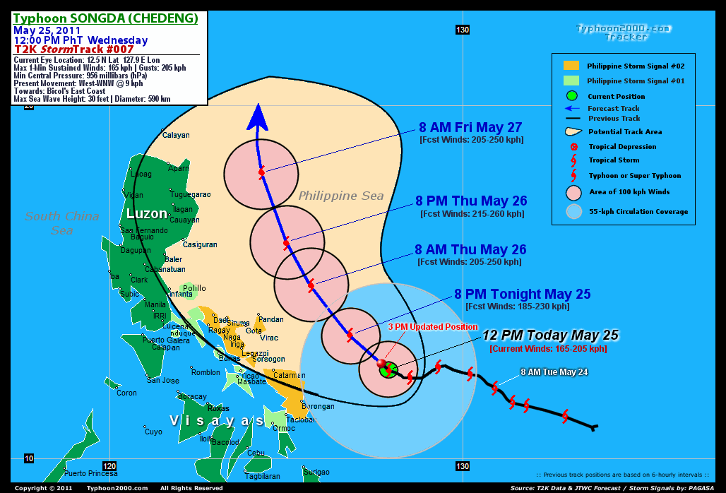
T2K TrackMap (for Public): 12:00 PM PhT Wed May 25
FORECAST OUTLOOK ANALYSIS (up to 2 days)* SONGDA's CLOSEST POINT OF APPROACH (CPA)* EXTENDED FORECAST TRACK (3 to 5 days)* EFFECTS & HAZARDS SUMMARY
SONGDA (CHEDENG) is expected to continue intensifying and shall turn NW to NNW-ward across the Philippine Sea, just to the east of Luzon within the next 2 days. The typhoon is likely to pass more or less 250 km to the NE of Bicol Region by tomorrow morning - upon reaching Category 3 strength. THIS EVENING (WED): Upgraded to Category 3 as it turns NW-ward...about 280 km East of Virac, Catanduanes [8PM MAY 25: 13.5N 126.8E @ 185kph]. TOMORROW MORNING (THU): Passing just to the NE of Bicol...about 185 km NE of Guigmoto, Catanduanes [8AM MAY 26: 14.9N 125.7E @ 205kph]. TOMORROW EVENING (THU): Upgraded to Category 4 as it turns more NNW-ward...about 310 km East of Casiguran, Aurora [8PM MAY 26: 16.1N 125.0E @ 215kph]. FRIDAY MORNING: Downgraded to Category 3 while over the Northern Philippine Sea, just to the east of Cagayan Province (NE Luzon)...about 285 km East of Aparri, Cagayan [8AM MAY 27: 18.1N 124.2E @ 205kph].
Maximum Sustained Winds (1-min. avg) have increased to near 165 km/hr (90 knots) with higher gusts. SONGDA (CHEDENG) is now a Category 2 Typhoon on the Saffir-Simpson Tropical Cyclone Scale. Typhoon Force Winds (118 km/hr or more) extend outward up to 65 kilometers (35 nautical miles) from the center...and Tropical Storm Force Winds (62-117 km/hr) extend outward up to 215 kilometers (115 nautical miles). SONGDA is an average-sized tropical cyclone with a diameter of 590 kilometers (320 nautical miles). CATANDUANES: about 185 km ENE of Pandan or 215 km NE of Virac [between 8:00-10:00 AM Tomorrow]. CAMARINES SUR: about 240 km NE of Caramoan or 305 km NE of Metro Naga [between 8:00-10:00 AM Tomorrow]. ALBAY: about 285 km NE of Legazpi City [between 4:00-6:00 AM Tomorrow]. SORSOGON: about [between 2:00-4:00 AM Tomorrow].
SATURDAY MORNING: Recurves towards the NNE, passing east of Taiwan [8AM MAY 28: 22.6N 124.8E @ 195kph]. SUNDAY MORNING: Near Naje Island (Ryukyus) [8AM MAY 29: 28.9N 129.9E @ 150kph]. MONDAY MORNING: Becomes Extratropical while passing along the coast of Honshu, just south of Tokyo [8AM MAY 30: 33.3N 140.3E @ 100kph].
*Please be reminded that the Forecast Outlook changes every 6 hours, and the Extended Forecast Track have an average error of 250 km on Day 3...450 km on Day 4...and 650 km on Day 5, while the wind speed forecast error, averages 35 kph per day. Therefore, a turn to the left or right of its future track and changes in its wind speed must be anticipated from time to time.
SONGDA's circulation improving as the system slows down...irregular eye can now be seen on satellite imageries. Below are the summary of the typhoon's parts and its hazards affecting specific areas: CLOUD-FILLED EYE - still over water (Philippine Sea)...not affecting any land areas. Possible calm and lull conditions (with <20 kph winds) can be expected inside the eye (click here to know more about the EYE). EYEWALL - still over water (Philippine Sea)...not affecting any land areas. Typhoon Conditions with typhoon force winds (>118 kph) can be expected within this wall (click here to know more about the Eyewall). INNER RAINBANDS - still over water...not affecting any land areas. Tropical Storm Conditions w/ Tropical Storm Force Winds (65-117 kph) can be expected along these bands. OUTER RAINBANDS - spreading across Bicol Region, Masbate, & Eastern Visayas. Tropical Depression Conditions w/ moderate to strong winds (30-61 kph) can be expected along these bands (click here to know more about Rainbands). 24HR TOTAL RAINFALL ACCUMULATION - from 5 up to 200 mm (low to high rainfall) can be expected along the outer & inner rainbands...with isolated amounts of up to 400 mm (high) near the center of SONGDA. [click to open NOAA's eTRaP graphic]. COASTAL STORM SURGE FLOODING - possible 4 to 5 feet above normal tide levels...accompanied by large and dangerous battering waves can be expected along the coastal and beach front areas of Bicol Region & Samar Provinces today. Minimal damage is likely on this type of storm surge. Danger from Rip Currents or Rip Tides can be expected along the beach-front areas of Eastern Visayas and Eastern Luzon today. (click here to know more about Storm Surge).
CURRENT SW MONSOON INTENSITY: MODERATE >> Mostly cloudy with occasional squalls, rains & thunderstorms can be expected along the following affected areas: PALAWAN & WESTERN MINDANAO. Light to moderate SW to Westerly winds (not in excess of 40 kph) will blow.
Important Note: Please keep in mind that the above forecast outlook, extended forecast, effects-hazards, current monsoon intensity, & tropical cyclone watch changes every 6 to 12 hrs!![]()
PAGASA Philippine Storm Warnings Signals
PHILIPPINE STORM WARNING SIGNAL # TWO (2) 
Now In Effect: CATANDUANES, SORSOGON, ALBAY, CAMARINES SUR, CAMARINES NORTE, & SAMAR PROVINCES.
The above areas will experience stormy weather - where winds of 60-100 kph can be expected beginning this afternoon or evening. Coastal waters will be rough to very rough and extremely dangerous to all types of seacrafts. PHILIPPINE STORM WARNING SIGNAL # ONE (1) The above areas will have rains and winds of not more than 60 kph beginning tonight. Coastal waters will be moderate to rough.
In Effect: MARINDUQUE, MASBATE, BURIAS IS., TICAO IS., SOUTHERN QUEZON, POLILLO IS., NORTHERN LEYTE, & BILIRAN IS.
Residents living in low-lying and mountainous areas under Public Storm Warning Signal Number 1 are alerted against flashfloods, mudslides and landslides...while those living in coastal & beach-front areas are advised to seek higher grounds due to possible storm surge (aka. big waves).
JTWC (US NAVY & AIR FORCE) REMARKS:
REMARKS (for Meteorologists): 8 AM (00 GMT) WED 25 MAY POSITION: 12.4N 128.1E.
*..(more)
>> SONGDA, meaning: A river in northwestern Viet Nam. Name contributed by:Viet Nam.
_______________________________________________________________________________________________________________________________________
RECENT TYPHOON2000.COM TRACKING CHART:
_________________________________________________________________________________________________________________
RECENT MULTI-AGENCY TROPICAL CYCLONE FORECAST TRACKING CHART: 

> Image source: NOAA SATELLITE CENTER: http://www.ssd.noaa.gov/mtsat/flt/t1/rgb.jpg
> Image source: Wunderground.com Tropical Page (http://www.wunderground.com/tropical)
____________________________________________________________________________________________________________________
LATEST 24 HR. TOTAL RAINFALL AMOUNTS / ENSEMBLE TROPICAL RAINFALL POTENTIAL (eTRaP):

> Image source: NOAA Satellite & Information Service (http://www.ssd.noaa.gov/PS/TROP/etrap.html)
>> To know the meteorological terminologies and acronyms used on this update visit the ff:
http://typhoon2000.ph/tcterm.htm
http://www.nhc.noaa.gov/aboutgloss.shtml
http://www.srh.noaa.gov/oun/severewx/glossary.php
http://www.srh.weather.gov/fwd/glossarynation.html
http://www.nhc.noaa.gov/acronyms.shtml
__________________________________________________________________________________________
For the complete details on TY SONGDA (CHEDENG)...go visit our website @:
> http://www.typhoon2000.com
> http://www.maybagyo.com
Copyright © 2011 Typhoon2000.com All Rights Reserved

No comments:
Post a Comment