
for Saturday, 07 May 2011 [6:14 AM PhT]![]()

<<<Typhoon2000.com Mobile >>>
Get the latest 3-Hourly SMS Storm Alerts on BEBENG!
For more details: Text T2K TYPHOON to
2800 (Globe/TM) | 216 (Smart/TNT) | 2288 (Sun)
*only P2.50 (Smart/Globe) / P2.00 (Sun) per msg received.
powered by: Synermaxx
Typhoon2000 (T2K) NEWS (Saturday May 07 2011):
Now issuing 3-hrly web and e-mail updates (except 12 AM) on TD 03W (BEBENG) as it nears Samar-Bicol Area.
03W (BEBENG) MAX WIND SPEED PER AGENCY:
+ USA (JTWC/1-min avg): 55 km/hr
+ Japan (JMA/10-min avg): 55 km/hr
+ Philippines (PAGASA/10-min avg): 55 km/hr
TROPICAL DEPRESSION 03W [BEBENG]
T2K PUBLIC ADVISORY NUMBER 002
6:00 AM PhT (22:00 GMT) Sat 07 May 2011
Sources: T2K Extrap Analysis/JTWC Warning #003/SatFixes
View: Advisory Archives (2004-2011)
Tropical Depression 03W (BEBENG) intensifying as it nears Samar-Bicol Area...Inner rainbands now spreading across Samar.
Residents and visitors along Eastern Luzon, Bicol Region and Eastern Visayas should closely monitor the progress of 03W (BEBENG).
Do not use this for life or death decision. This advisory is intended for additional information purposes only. Kindly refer to your country's official weather agency for local warnings, advisories & bulletins.
CURRENT STORM INFORMATION
Time/Date: 6:00 AM PhT Sat May 07 2011
Location of Center: 12.2º N Lat 127.0º E Lon
Distance 1: 185 km (100 nm) ENE of Borongan City
Distance 2: 265 km (143 nm) ESE of Catarman, N.Samar
Distance 3: 335 km (180 nm) ESE of Sorsogon City
Distance 4: 340 km (183 nm) SE of Virac, Catanduanes
Distance 5: 370 km (200 nm) ESE of Legazpi City
Distance 6: 440 km (238 nm) SE of Metro Naga/CWC
Distance 7: 700 km (378 nm) SE of Metro Manila
MaxWinds (1-min avg): 55 kph (30 kts) near the center
Peak Wind Gusts: 75 kph (40 kts)
Present Movement: WNW @ 09 kph (05 kts)
Towards: Eastern Coast of Bicol
CPA over Bicol Area: 6AM-4PM Sunday
24hr Total Rainfall (near center): 300 mm (Heavy-Very Heavy)
Minimum Central Pressure: 1000 millibars (hPa)
Saffir-Simpson Typhoon Scale: TD
Size (in Diameter): 500 km (270 nm) / Average
Max Sea Wave Height (near center): 10 ft (3.0 m)
Possible Storm Surge Height: 0 ft [0 m]
T2K TrackMap (for Public): 6:00 AM PhT Sat May 07
FORECAST OUTLOOK ANALYSIS (up to 48 hours)* EXTENDED FORECAST TRACK (3 to 5 days)*
03W is forecast to pick-up speed and track WNW to NW-ward in the direction of the Eastern Coast of the Bicol Region for the next 2 days and intensify. This system may reach Tropical Storm (TS) strength this afternoon, about 240 km East of Sorsogon City [2PM MAY 07: 12.7N 126.2E @ 65kph], and shall pass over the northern tip of Catanduanes tomorrow morning (Sun May 08) between 6-7AM...about 45 km to the North of Virac, Catanduanes or 115 km ENE of Metro Naga. Its Closest Point of Approach (CPA) to Metro Naga shall be more or less 100 km to the NE of the city around 12 noon tomorrow. By early Monday morning (May 9), it shall be approaching the southern coast of Aurora w/ estimated wind speeds of 95 kph [2AM MAY 08: 13.6N 124.9E @ 75kph...2PM MAY 08: 14.5N 123.5E @ 85kph...2AM MAY 09: 15.6N 122.3E @ 95kph].
Maximum Sustained Winds (1-min. avg) are now near 55 km/hr (30 knots) with higher gusts. 03W (BEBENG) is a Tropical Depression on the Saffir-Simpson Tropical Cyclone Scale.  TUESDAY EARLY MORNING: Weakening after traversing Northern Luzon...shall be over Ilocos Provinces...about 45 km SSE of Laoag City [2AM MAY 10: 17.8N 120.7E @ 75kph]. WEDNESDAY EARLY MORNING: Recurving towards the north in response to a passing Cold Front along Taiwan-Okinawa Area...shall be over the Bashi Channel...about 145 km West of Basco, Batanes [2AM MAY 11: 20.4N 120.5E @ 65kph]. THURSDAY EARLY MORNING: Downgraded to a Tropical Depression as it merges with the frontal system...shall be over the east coast of Taiwan...about 55 km South of Hualien City, Taiwan [2AM MAY 12: 23.5N 121.7E @ 55kph].
*Please be reminded that the Forecast Outlook changes every 6 hours, and the Extended Forecast Track have an average error of 250 km on Day 3...450 km on Day 4...and 650 km on Day 5, while the wind speed forecast error, averages 35 kph per day. Therefore, a turn to the left or right of its future track and changes in its wind speed must be anticipated from time to time.
EFFECTS & HAZARDS SUMMARY
03W's circulation remains over water (South Philippine Sea) w/ its improving rainbands affecting the Bicol Region, Visayas & Northeastern Mindanao. Below are the summary of the depression's parts and its hazards affecting specific areas: INNER RAINBANDS - now affecting Samar Provinces...and is expected to reach the Bicol Region this afternoon or tonight. Tropical Depression Conditions w/ Gale Force Winds (<65 kph) can be expected along these bands. OUTER RAINBANDS - spreading across the Bicol Region, Masbate, & Rest of Visayas, where light to moderate winds (<35 kph) can be expected along these bands. (click here to know more about Rainbands). 24HR TOTAL RAINFALL ACCUMULATION - from 5 up to 150 mm (light to heavy rain) can be expected along the outer & inner rainbands...with isolated amounts of up to 300 mm (heavy to very heavy) near the center of 03W. [click to open NOAA's eTRaP graphic].
TROPICAL CYCLONE WATCH CURRENT ITCZ/MONSOON TROUGH INTENSITY: MODERATE >> Partly sunny to mostly cloudy with scattered showers, rains & thunderstorms can be expected along these following affected areas: PALAWAN & MINDANAO. Light to moderate W, SW to variable winds (not in excess of 35 kph) can be expected today and tomorrow.
Tropical Disturbance 94W (LPA/1010 MB) currently disorganized over the Caroline Islands just north of the Equator, south of Guam. The ill-defined center was located near lat 2.5N lon 144.7E...about 1250 km SE of Palau Islands or 2075 km SE of Mindanao, PH...with 1-min maximum sustained winds of 30 kph near the center. The 48-Hr. Tropical Cyclone Formation Potential on this system remains @ 30%. Click here to view current satellite image and flash animation.
Important Note: Please keep in mind that the above forecast outlook, extended forecast, effects-hazards, current monsoon intensity, & tropical cyclone watch changes every 6 to 12 hrs!
JTWC (US NAVY & AIR FORCE) REMARKS:
REMARKS (for Meteorologists): 2 AM (18 GMT) SAT 07 MAY POSITION: 11.9N 127.3E.
*RECENT INFRARED SATELLITE IMAGERY INDICATES DEEP CONVECTION LOCATED
PRIMARILY ALONG THE WESTERN SEMICIRCLE OF THE LOW LEVEL CIRCULATION
CENTER (LLCC). A MUCH WEAKER BAND IS LOCATED WELL TO THE EAST OF THE
LLCC. A 06/1827Z 85H TRMM MICROWAVE SATELLITE IMAGE ALSO SHOWS DEEP
CONVECTION JUST OFF THE EAST COAST OF SAMAR. ANIMATED WATER VAPOR
IMAGERY SHOWS MOSTLY RADIAL OUTFLOW AND FAVORABLE DIVERGENCE ALOFT.
TD 03W HAS MAINTAINED A CONSISTENT INTENSITY OF 30 KNOTS OVER THE PAST 06
HOURS. THE INTENSITY IS SUPPORTED BY PGTW AND KNES DVORAK INTENSITY
ESTIMATES RANGING FROM 25 TO 30 KNOTS AND A 06/1213Z ASCAT PASS
DEPICTING 30 KNOT WINDS NEAR THE LLCC. POSITION CONFIDENCE IS HIGH
BASED ON THE MICROWAVE IMAGERY AND ASCAT PASS. 06/1200Z UPPER LEVEL
ANALYSIS PLACES TD 03W JUST SOUTHWEST OF AN ANTICYCLONE IN A REGION
OF FAVORABLE (5-10 KNOTS) VERTICAL WIND SHEAR. THIS SYSTEM IS
EXPECTED TO CONTINUE TRACKING WEST-NORTHWEST THROUGH TAU 48 AND
INTENSIFY BEFORE MAKING A POLEWARD TURN AROUND THE WESTERN PERIPHERY
OF THE SUBTROPICAL RIDGE AXIS. A PEAK INTENSITY OF 50 KNOTS IS
EXPECTED BY 08/1800Z, JUST PRIOR TO MAKING LANDFALL OVER NORTHERN
LUZON. WEAKENING IS EXPECTED TO OCCUR BY TAU 72 AS THE SYSTEM
INTERACTS WITH THE RUGGED TERRAIN OF LUZON BEFORE RE-EMERGING OVER
WATER. TC 03W IS THEN EXPECTED TO CONTINUE WEAKENING AS IT TRACKS
TOWARD TAIWAN AND ENCOUNTERS INCREASED VERTICAL WIND SHEAR AND IS
INFLUENCED BY AN APPROACHING MID-LATITUDE TROUGH. NUMERICAL MODEL
GUIDANCE IS IN GOOD AGREEMENT; THEREFORE THIS FORECAST IS CLOSE TO
MODEL CONSENSUS...(more)
_______________________________________________________________________________________________________________________________________
RECENT TYPHOON2000.COM TRACKING CHART: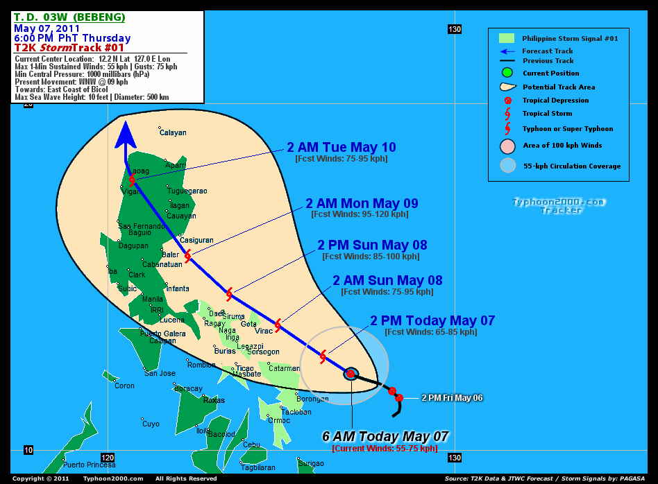
RECENT MULTI-AGENCY TROPICAL CYCLONE FORECAST TRACKING CHART:

> Image source: NOAA SATELLITE CENTER: http://www.ssd.noaa.gov/mtsat/flt/t1/rgb.jpg
> Image source: Wunderground.com Tropical Page (http://www.wunderground.com/tropical)
____________________________________________________________________________________________________________________
LATEST 24 HR. TOTAL RAINFALL AMOUNTS / ENSEMBLE TROPICAL RAINFALL POTENTIAL (eTRaP):

> Image source: NOAA Satellite & Information Service (http://www.ssd.noaa.gov/PS/TROP/etrap.html)
>> To know the meteorological terminologies and acronyms used on this update visit the ff:
http://typhoon2000.ph/tcterm.htm
http://www.nhc.noaa.gov/aboutgloss.shtml
http://www.srh.noaa.gov/oun/severewx/glossary.php
http://www.srh.weather.gov/fwd/glossarynation.html
http://www.nhc.noaa.gov/acronyms.shtml
__________________________________________________________________________________________
For the complete details on TD 03W (BEBENG)...go visit our website @:
> http://www.typhoon2000.com
> http://www.maybagyo.com
Copyright © 2011 Typhoon2000.com All Rights Reserved

No comments:
Post a Comment