
for Monday, 23 May 2011 [7:00 PM PhT]![]()

<<<Typhoon2000.com Mobile >>>
Get the latest 6-hrly SMS Storm Alerts on CHEDENG!
For more details: Text T2K TYPHOON to
2800 (Globe/TM) | 216 (Smart/TNT) | 2288 (Sun)
*Only P2.50 (Smart/Globe) / P2.00 (Sun) per msg received.
Click here on how to use this service (in PDF file)
Powered by: Synermaxx Corporation
Typhoon2000 (T2K) NEWS (Monday May 23 2011):
Currently issuing 6-hrly web, twitter, SMS and e-mail updates (except 12 AM) on TS SONGDA (CHEDENG).
SONGDA (CHEDENG) MAX WIND SPEED PER AGENCY:
+ USA (JTWC/1-min avg): 110 km/hr
+ Philippines (PAGASA/10-min avg): 95 km/hr
+ Japan (JMA/10-min avg): 95 km/hr
+ Korea (KMA/10-min avg): 95 km/hr
+ Taiwan (CWB/10-min avg): 100 km/hr
+ Beijing (NMC/2-min avg): 100 km/hr
+ Hong Kong (HKO/10-min avg): 95 km/hr
:: Click here to see Multi-Agency Forecast Tracks
TROPICAL STORM SONGDA [CHEDENG/04W/1102]
T2K PUBLIC ADVISORY NUMBER 011
6:00 PM PhT (10:00 GMT) Mon 23 May 2011
Sources: T2K Extrap Analysis/JTWC Warning #013/SatFixes
View: Advisory Archives (2004-2011)
Tropical Storm SONGDA (CHEDENG) moving a little bit faster over the Philippine Sea...no change in strength.
Residents and visitors along the Eastern Coast of Luzon, Bicol Region & Eastern Visayas should closely monitor the progress of SONGDA (CHEDENG).
Do not use this for life or death decision. This advisory is intended for additional information purposes only. Kindly refer to your country's official weather agency for local warnings, advisories & bulletins.
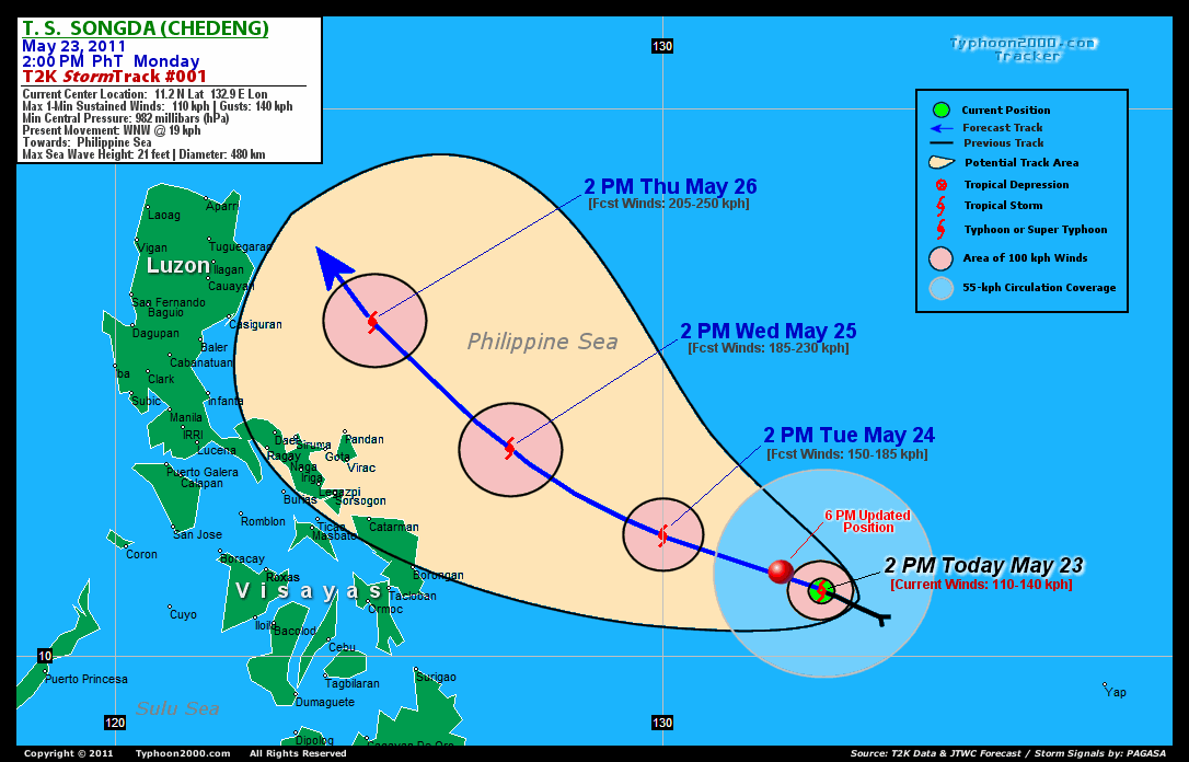
CURRENT STORM INFORMATION
Time/Date: 6:00 PM PhT Mon May 23 2011
Location of Center: 11.6º N Lat 132.2º E Lon
Distance 1: 740 km (400 nm) East of Borongan City
Distance 2: 830 km (448 nm) ESE of Catarman, N.Samar
Distance 3: 895 km (483 nm) ESE of Virac, Catanduanes
Distance 4: 905 km (490 nm) ESE of Sorsogon City
Distance 5: 940 km (507 nm) ESE of Legazpi City
Distance 6: 1000 km (540 nm) ESE of Metro Naga/CWC
MaxWinds (1-min avg): 110 kph (60 kts) near the center
Peak Wind Gusts: 140 kph (75 kts)
Present Movement: WNW @ 20 kph (11 kts)
Towards: Philippine Sea
CPA near Bicol Coast: 2PM Wed-2PM Thu
24hr Rainfall Accum (near center): 500 mm (Very High)
Rainrate (near center): 20-30 mm/hr (Mod-Heavy) new!
Minimum Central Pressure: 978 millibars (hPa)
Saffir-Simpson Typhoon Scale: TS
Size (in Diameter): 480 km (260 nm) / Average
Max Sea Wave Height (near center): 21 ft (6.4 m)
Possible Storm Surge Height: 0-3 ft [0-0.9 m]
T2K TrackMap (for Public): 6:00 PM PhT Mon May 23
FORECAST OUTLOOK ANALYSIS (up to 48 hours)* EXTENDED FORECAST TRACK (3 to 5 days)*
SONGDA (CHEDENG) is expected to continue intensifying while maintaining its WNW track across the Philippine Sea within the next 2 days. The storm is likely to be upgraded to a Category 1 Typhoon later tonight or early tomorrow morning [2AM MAY 24: 11.7N 131.4E @ 130kph...2PM MAY 24: 12.2N 130.0E @ 150kph]. As SONGDA moves across the warm Philippine Sea - it will therefore gain more strength - becoming a Category 3 Typhoon by Wednesday afternoon - as it approaches the Sea east of the Bicol Region...about 315 km East of Guigmoto, Catanduanes [2AM MAY 25: 12.8N 128.8E @ 165kph...2PM MAY 25: 13.8N 127.2E @ 185kph]. SONGDA's (CHEDENG) closest approach (CPA) to Catanduanes shall be about 205 km NE of Pandan or 235 km NE of Virac around 8AM on Thursday (May 26). While its closest approach (CPA) to Camarines Sur shall be about 270 km NE of Siruma or 310 km NE of Metro Naga around 2PM on Thursday.
Maximum Sustained Winds (1-min. avg) are near 110 km/hr (60 knots) with higher gusts. SONGDA (CHEDENG) is a strong Tropical Storm (TS) on the Saffir-Simpson Tropical Cyclone Scale. Tropical Storm Force Winds (62-117 km/hr) extend outward up to 185 kilometers (100 nautical miles) from the center. SONGDA is an average-sized tropical cyclone with a diameter of 480 kilometers (260 nautical miles).  THURSDAY AFTERNOON: Steadily intensifying as it turns NW'ly across the Philippine Sea...passing to the Sea east of Northern Luzon...about 280 km East of Casiguran, Aurora [2PM MAY 26: 16.1N 124.7E @ 205kph]. FRIDAY AFTERNOON: Upgraded to a Category 4 Typhoon - as it begins to turn more NNW'ly...passing close to the northeastern tip of Cagayan...about 140 km ESE of Calayan Is., Cagayan [2PM MAY 27: 19.1N 122.8E @ 215kph]. SATURDAY AFTERNOON: Remains at Category 4 strength - as it starts to recurve towards the North...passing near the Eastern Coast of Taiwan...about 175 km ESE of Hualien City, Taiwan [2PM MAY 28: 23.2N 123.1E @ 215kph].
*Please be reminded that the Forecast Outlook changes every 6 hours, and the Extended Forecast Track have an average error of 250 km on Day 3...450 km on Day 4...and 650 km on Day 5, while the wind speed forecast error, averages 35 kph per day. Therefore, a turn to the left or right of its future track and changes in its wind speed must be anticipated from time to time.
EFFECTS & HAZARDS SUMMARY
SONGDA's CDO continues to organize near its center, with somewhat broken rainbands along its NW and SW periphery. Latest satellite imagery continues to show a possible eye formation underneath the cirrus shield canopy - a sign that the system is near typhoon strength. Below are the summary of the storm's parts and its hazards affecting specific areas: CENTRAL DENSE OVERCAST (CDO) - remains over water (Philippine Sea)...possible "Eye" forming underneath. Tropical Storm Conditions w/ moderate to strong winds (62-117 kph) will be expected along the CDO. (click here to know more about CDO). INNER RAINBANDS - remains over water...not affecting any islands. Tropical Depression Conditions w/ moderate to strong winds (30-61 kph) will continue to prevail along these bands until tonight. OUTER RAINBANDS - continues to spread across the Caroline Islands including Palau, Yap, & Ulithi Islands in Western Micronesia...now moving into the Southeastern Philippine Sea - light to moderate winds (<30 kph) will be expected along these bands. (click here to know more about Rainbands). 24HR TOTAL RAINFALL ACCUMULATION - from 5 up to 280 mm (low to high rainfall) can be expected along the outer & inner rainbands...with isolated amounts of up to 500 mm (very high) near the center of SONGDA. [click to open NOAA's eTRaP graphic].
CURRENT I.T.C.Z. (MONSOON TROUGH) INTENSITY: STRONG >> Partly sunny to mostly cloudy with scattered to widespread showers, rains & thunderstorms will prevail along the following affected areas: SOUTHERN LUZON, BICOL REGION, VISAYAS & MINDANAO. Light to moderate SE to variable winds (not in excess of 35 kph) will be expected.
Important Note: Please keep in mind that the above forecast outlook, extended forecast, effects-hazards, current monsoon intensity, & tropical cyclone watch changes every 6 to 12 hrs!
JTWC (US NAVY & AIR FORCE) REMARKS:
REMARKS (for Meteorologists): 2 PM (06 GMT) MON 23 MAY POSITION: 11.2N 132.9E.
*TROPICAL STORM (TS) 04W (SONGDA), LOCATED APPROXIMATELY 250 NM NORTH-
NORTHWEST OF PALAU, HAS TRACKED WEST-NORTHWESTWARD AT 10 KNOTS OVER
THE PAST SIX HOURS. ANIMATED MULTISPECTRAL SATELLITE IMAGERY (MSI)
AND RECENT MICROWAVE IMAGERY (222340Z SSMIS AND 230505Z AMSU) DEPICT
AN INTENSE CONVECTIVE BAND DISPLACED TO THE SOUTH OF A CONSOLIDATING
LOW LEVEL CIRCULATION CENTER WITH A SLIGHT WEAKENING IN CENTRAL DEEP
CONVECTION OVER THE PAST SIX HOURS. THERE IS GOOD CONFIDENCE IN THE
CURRENT POSITION BASED ON THE 230505Z AMSU IMAGE AND ANIMATED MSI.
THE CURRENT INTENSITY IS SLIGHTLY LOWER THEN DVORAK INTENSITY
ESTIMATES FROM PGTW AND KNES OF 65 KNOTS, BASED ON A SLIGHT
WEAKENING IN CENTRAL CONVECTION AND A 230016Z ASCAT PASS INDICATING
50 KNOT WINDS NEAR THE CENTER. UPPER LEVEL ANALYSIS INDICATES THAT
THE SYSTEM HAS GOOD OVERALL OUTFLOW IN ALL QUADRANTS, EXCEPT THE
NORTHWESTERN QUADRANT, WHERE A DIGGING UPPER LEVEL TROUGH, EVIDENT
IN ANIMATED WATER VAPOR IMAGERY AND THE 23/00Z STREAMLINE ANALYSIS,
IS CAUSING SUBSIDENCE AND INCREASED NORTHWESTERLY VERTICAL WIND
SHEAR (15-20 KNOTS). TS SONGDA IS TRACKING WEST-NORTHWESTWARD ALONG
THE SOUTHWEST PERIPHERY OF THE MID-LEVEL SUBTROPICAL STEERING RIDGE
AND IS FORECAST TO TURN INCREASINGLY POLEWARD IN THE EXTENDED TAUS.
THE SYSTEM IS FORECAST TO RE-CURVE EAST OF TAIWAN NEAR TAU 120 AND
TRACK TOWARDS OKINAWA AND WESTERN HONSHU AFTER THIS FORECAST PERIOD.
NUMERICAL MODEL GUIDANCE REMAINS IN VERY GOOD AGREEMENT WITH ALL
MODELS CONTINUING TO SUPPORT A RE-CURVE SCENARIO, AND TRACK EAST OF
TAIWAN. BASED ON HIGH DEGREE OF AGREEMENT AMONGST THE DYNAMIC AIDS,
THIS FORECAST REMAINS CLOSE TO THE MODEL CONSENSUS BUT SLIGHTLY
FASTER AND TO THE EAST. TS 04W IS EXPECTED TO REACH A PEAK INTENSITY
NEAR 115 KNOTS BETWEEN TAU 96 AND 120 DUE TO FAVORABLE ENVIRONMENTAL
CONDITIONS...(more)
>> SONGDA, meaning: A river in northwestern Viet Nam. Name contributed by:Viet Nam.
_______________________________________________________________________________________________________________________________________
RECENT TYPHOON2000.COM TRACKING CHART:
_________________________________________________________________________________________________________________
RECENT MULTI-AGENCY TROPICAL CYCLONE FORECAST TRACKING CHART: 

> Image source: NOAA SATELLITE CENTER: http://www.ssd.noaa.gov/mtsat/flt/t1/rgb.jpg
> Image source: Wunderground.com Tropical Page (http://www.wunderground.com/tropical)
____________________________________________________________________________________________________________________
LATEST 24 HR. TOTAL RAINFALL AMOUNTS / ENSEMBLE TROPICAL RAINFALL POTENTIAL (eTRaP):

> Image source: NOAA Satellite & Information Service (http://www.ssd.noaa.gov/PS/TROP/etrap.html)
>> To know the meteorological terminologies and acronyms used on this update visit the ff:
http://typhoon2000.ph/tcterm.htm
http://www.nhc.noaa.gov/aboutgloss.shtml
http://www.srh.noaa.gov/oun/severewx/glossary.php
http://www.srh.weather.gov/fwd/glossarynation.html
http://www.nhc.noaa.gov/acronyms.shtml
__________________________________________________________________________________________
For the complete details on TS SONGDA (CHEDENG)...go visit our website @:
> http://www.typhoon2000.com
> http://www.maybagyo.com
Copyright © 2011 Typhoon2000.com All Rights Reserved

No comments:
Post a Comment