
for Monday, 09 May 2011 [9:45 PM PhT]![]()

<<<Typhoon2000.com Mobile >>>
Get the latest 3-Hourly SMS Storm Alerts on BEBENG!
For more details: Text T2K TYPHOON to
2800 (Globe/TM) | 216 (Smart/TNT) | 2288 (Sun)
*only P2.50 (Smart/Globe) / P2.00 (Sun) per msg received.
powered by: Synermaxx
Typhoon2000 (T2K) NEWS (Monday May 09 2011):
Resuming 6-hrly web and e-mail updates (except 12 AM) on TS AERE (BEBENG).
AERE (BEBENG) MAX WIND SPEED PER AGENCY:
+ USA (JTWC/1-min avg): 75 km/hr
+ Japan (JMA/10-min avg): 75 km/hr
+ Philippines (PAGASA/10-min avg): 75 km/hr
+ Beijing (NMC/2-min avg): 65 km/hr
+ Korea (KMA/10-min avg): 75 km/hr
+ Taiwan (CWB/10-min avg): 75 km/hr
+ Hong Kong (HKO/10-min avg): 75 km/hr
:: Click here to see Multi-Agency Forecast Tracks
TROPICAL STORM AERE [BEBENG/03W/1101]
T2K PUBLIC INTERMEDIATE ADVISORY NUMBER 012A
9:00 PM PhT (13:00 GMT) Mon 09 May 2011
Sources: T2K Extrap Analysis/JTWC Warning #013/SatFixes
View: Advisory Archives (2004-2011)
Tropical Storm AERE (BEBENG) now off the east coast of Cagayan...may sccelerate soon towards the NNE or NE.
Residents and visitors along Northern & Central Luzon should closely monitor the progress of AERE (BEBENG).
Do not use this for life or death decision. This advisory is intended for additional information purposes only. Kindly refer to your country's official weather agency for local warnings, advisories & bulletins.
CURRENT STORM INFORMATION
Time/Date: 9:00 PM PhT Mon May 09 2011
Location of Center: 18.1º N Lat 122.5º E Lon
Distance 1: 90 km (48 nm) ESE of Aparri, Cagayan
Distance 2: 100 km (55 nm) NE of Tuguegarao City
Distance 3: 125 km (67 nm) NNE of Ilagan City
Distance 4: 160 km (85 nm) NNE of Cauayan, Isabela
Distance 5: 170 km (92 nm) SE of Calayan Island
Distance 6: 270 km (147 nm) SSE of Basco, Batanes
MaxWinds (1-min avg): 75 kph (40 kts) near the center
Peak Wind Gusts: 95 kph (55 kts)
Present Movement: North @ 13 kph (07 kts)
Towards: Philippine Sea
CPA over Eastern Cagayan: Ongoing til 1AM
24hr Total Rainfall (near center): 150 mm (Heavy)
Minimum Central Pressure: 993 millibars (hPa)
Saffir-Simpson Typhoon Scale: TS
Size (in Diameter): 335 km (180 nm) / Small/Avg
Max Sea Wave Height (near center): 16 ft (4.8 m)
Possible Storm Surge Height: 0-3 ft [0-0.9 m]
T2K TrackMap (for Public): 9:00 PM PhT Mon May 09
_______________________________________________________________________________________________________________________________________
RECENT TYPHOON2000.COM TRACKING CHART: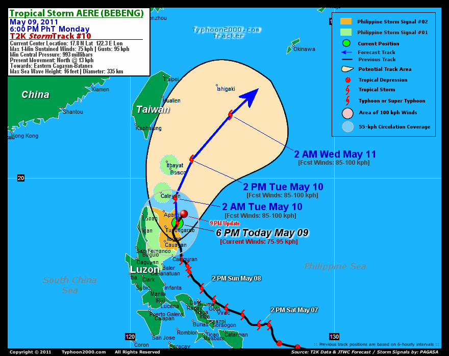
RECENT MULTI-AGENCY TROPICAL CYCLONE FORECAST TRACKING CHART:


> Image source: NOAA SATELLITE CENTER: http://www.ssd.noaa.gov/mtsat/flt/t1/rgb.jpg
> Image source: Wunderground.com Tropical Page (http://www.wunderground.com/tropical)
____________________________________________________________________________________________________________________
LATEST 12-18HR. TOTAL RAINFALL AMOUNTS / ENSEMBLE TROPICAL RAINFALL POTENTIAL (eTRaP):

> Image source: NOAA Satellite & Information Service (http://www.ssd.noaa.gov/PS/TROP/etrap.html)
>> To know the meteorological terminologies and acronyms used on this update visit the ff:
http://typhoon2000.ph/tcterm.htm
http://www.nhc.noaa.gov/aboutgloss.shtml
http://www.srh.noaa.gov/oun/severewx/glossary.php
http://www.srh.weather.gov/fwd/glossarynation.html
http://www.nhc.noaa.gov/acronyms.shtml
__________________________________________________________________________________________
For the complete details on TS AERE (BEBENG)...go visit our website @:
> http://www.typhoon2000.com
> http://www.maybagyo.com
Copyright © 2011 Typhoon2000.com All Rights Reserved

No comments:
Post a Comment