
for Saturday, 07 May 2011 [8:45 PM PhT]![]()

<<<Typhoon2000.com Mobile >>>
Get the latest 3-Hourly SMS Storm Alerts on BEBENG!
For more details: Text T2K TYPHOON to
2800 (Globe/TM) | 216 (Smart/TNT) | 2288 (Sun)
*only P2.50 (Smart/Globe) / P2.00 (Sun) per msg received.
powered by: Synermaxx
Typhoon2000 (T2K) NEWS (Saturday May 07 2011):
Now issuing 3-hrly web and e-mail updates (except 12 AM) on TS AERE (BEBENG) as it nears Bicol Area.
AERE (BEBENG) MAX WIND SPEED PER AGENCY:
+ USA (JTWC/1-min avg): 65 km/hr
+ Japan (JMA/10-min avg): 65 km/hr
+ Philippines (PAGASA/10-min avg): 65 km/hr
+ Beijing (NMC/2-min avg): 65 km/hr
:: Click here to see Multi-Agency Forecast Tracks
TROPICAL STORM AERE [BEBENG/03W/1101]
T2K PUBLIC INTERMEDIATE ADVISORY NUMBER 004A
9:00 PM PhT (13:00 GMT) Sat 07 May 2011
Sources: T2K Extrap Analysis/JTWC Warning #005/SatFixes
View: Advisory Archives (2004-2011)
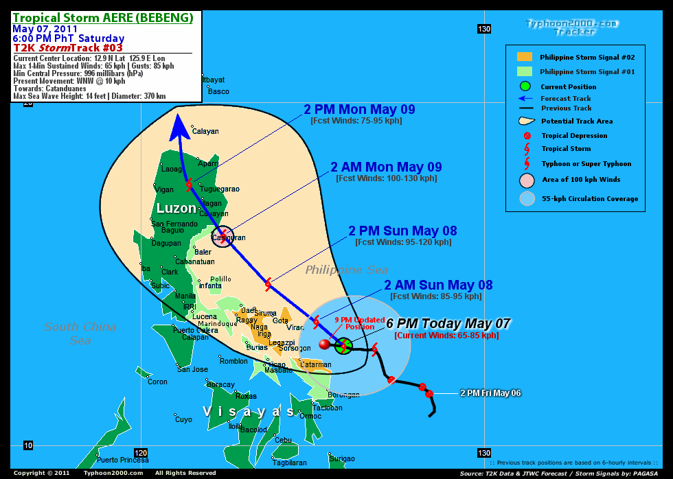
Tropical Storm AERE (BEBENG) has moved westward slowly during the past 3 hours, endangers the whole Bicol Region.
Residents and visitors along Eastern Luzon, Bicol Region & Eastern Visayas should closely monitor the progress of AERE (BEBENG).
Do not use this for life or death decision. This advisory is intended for additional information purposes only. Kindly refer to your country's official weather agency for local warnings, advisories & bulletins.
CURRENT STORM INFORMATION
Time/Date: 9:00 PM PhT Sat May 07 2011
Location of Center: 13.0º N Lat 125.5º E Lon
Distance 1: 110 km (60 nm) NE of Catarman, N.Samar
Distance 2: 155 km (83 nm) SE of Virac, Catanduanes
Distance 3: 160 km (85 nm) East of Sorsogon City
Distance 4: 195 km (105 nm) ESE of Legazpi City
Distance 5: 205 km (110 nm) SE of Gota Beach
Distance 6: 230 km (125 nm) ESE of Iriga City
Distance 7: 260 km (140 nm) ESE of Metro Naga/CWC
Distance 8: 265 km (143 nm) SE of Siruma, CamSur
Distance 9: 305 km (165 nm) ESE of Daet/Ragay
Distance 10: 515 km (278 nm) SE of Metro Manila
MaxWinds (1-min avg): 65 kph (35 kts) near the center
Peak Wind Gusts: 85 kph (45 kts)
Present Movement: West @ 10 kph (05 kts)
Towards: Catanduanes
CPA over Bicol Area: 2AM-2PM Sunday
24hr Total Rainfall (near center): 460 mm (Very Heavy)
Minimum Central Pressure: 996 millibars (hPa)
Saffir-Simpson Typhoon Scale: TS
Size (in Diameter): 370 km (180 nm) / Average
Max Sea Wave Height (near center): 14 ft (4.2 m)
Possible Storm Surge Height: 0-3 ft [0-0.9 m]
T2K TrackMap (for Public): 9:00 PM PhT Sat May 07
PAGASA Philippine Storm Warnings Signals
PHILIPPINE STORM WARNING SIGNAL # TWO (2) 
Now In Effect: CATANDUANES, CAMARINES SUR, ALBAY, SORSOGON, & NORTHERN SAMAR.
The above areas will experience stormy weather tonight & tomorrow (with winds not exceeding 85 kph). Coastal waters will be rough to very rough and extremely dangerous to all types of seacrafts. PHILIPPINE STORM WARNING SIGNAL # ONE (1) The above areas will have rains and winds of not more than 60 kph tonight until tomorrow. Coastal waters will be moderate to rough.
In Effect: MASBATE, TICAO & BURIAS ISLANDS, CAMARINES NORTE, QUEZON, POLILLO ISLANDS, AURORA, MARINDUQUE, EASTERN & WESTERN SAMAR.
Residents living in low-lying and mountainous areas under Public Storm Warning Signal Number 1 & 2 are alerted against possible flashfloods, mudslides and landslides...while those living in coastal & beach-front areas are advised to seek higher grounds due to possible storm surge (aka. big waves).
_______________________________________________________________________________________________________________________________________
RECENT TYPHOON2000.COM TRACKING CHART:
RECENT MULTI-AGENCY TROPICAL CYCLONE FORECAST TRACKING CHART:


> Image source: NOAA SATELLITE CENTER: http://www.ssd.noaa.gov/mtsat/flt/t1/rgb.jpg
> Image source: Wunderground.com Tropical Page (http://www.wunderground.com/tropical)
____________________________________________________________________________________________________________________
LATEST 24 HR. TOTAL RAINFALL AMOUNTS / ENSEMBLE TROPICAL RAINFALL POTENTIAL (eTRaP):

> Image source: NOAA Satellite & Information Service (http://www.ssd.noaa.gov/PS/TROP/etrap.html)
>> To know the meteorological terminologies and acronyms used on this update visit the ff:
http://typhoon2000.ph/tcterm.htm
http://www.nhc.noaa.gov/aboutgloss.shtml
http://www.srh.noaa.gov/oun/severewx/glossary.php
http://www.srh.weather.gov/fwd/glossarynation.html
http://www.nhc.noaa.gov/acronyms.shtml
__________________________________________________________________________________________
For the complete details on TS AERE (BEBENG)...go visit our website @:
> http://www.typhoon2000.com
> http://www.maybagyo.com
Copyright © 2011 Typhoon2000.com All Rights Reserved

No comments:
Post a Comment