
for Wednesday, 25 May 2011 [7:00 AM PhT]![]()

<<<Typhoon2000.com Mobile >>>
Get the latest 3-hrly SMS Storm Alerts on CHEDENG!
For more details: Text T2K TYPHOON to
2800 (Globe/TM) | 216 (Smart/TNT) | 2288 (Sun)
*Only P2.50 (Smart/Globe) / P2.00 (Sun) per msg received.
Click here on how to use this service (in PDF file)
Powered by: Synermaxx Corporation
Typhoon2000 (T2K) NEWS (Wednesday May 25 2011):
Now issuing 3-hrly web, twitter, SMS and e-mail updates on TY SONGDA (CHEDENG).
SONGDA (CHEDENG) MAX WIND SPEED PER AGENCY:
+ USA (JTWC/1-min avg): 140 km/hr
+ Philippines (PAGASA/10-min avg): 115 km/hr
+ Japan (JMA/10-min avg): 110 km/hr
+ Korea (KMA/10-min avg): 120 km/hr
+ Taiwan (CWB/10-min avg): 105 km/hr
+ Beijing (NMC/2-min avg): 140 km/hr
+ Hong Kong (HKO/10-min avg): 110 km/hr
:: Click here to see Multi-Agency Forecast Tracks
TYPHOON SONGDA [CHEDENG/04W/1102]
T2K PUBLIC ADVISORY NUMBER 016
6:00 AM PhT (22:00 GMT) Wed 25 May 2011
Sources: T2K Extrap Analysis/JTWC Warning #019/SatFixes
View: Advisory Archives (2004-2011)
Typhoon SONGDA (CHEDENG) has slowed down anew while gaining more strength during the past 6 hours...threat to Bicol Region and Samar Provinces remains...Outer rain bands now spreading across Samar Island.
Residents and visitors along the Eastern Luzon, Bicol Region & Eastern Visayas should closely monitor the progress of SONGDA (CHEDENG).
Do not use this for life or death decision. This advisory is intended for additional information purposes only. Kindly refer to your country's official weather agency for local warnings, advisories & bulletins.
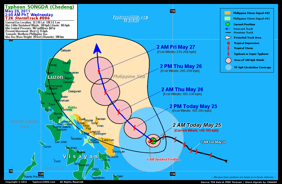
CURRENT STORM INFORMATION
Time/Date: 6:00 AM PhT Wed May 25 2011
Location of Eye: 12.2º N Lat 128.2º E Lon
Distance 1: 310 km (167 nm) ENE of Borongan City
Distance 2: 390 km (210 nm) ESE of Catarman, N.Samar
Distance 3: 460 km (248 nm) ESE of Virac, Catanduanes
Distance 4: 465 km (252 nm) ESE of Sorsogon City
Distance 5: 500 km (270 nm) ESE of Legazpi City
Distance 6: 535 km (290 nm) ESE of Iriga City
Distance 7: 565 km (305 nm) ESE of Metro Naga/CWC
MaxWinds (1-min avg): 140 kph (75 kts) near the center
Peak Wind Gusts: 165 kph (90 kts)
Present Movement: West @ 13 kph (07 kts)
Towards: Northern Philippine Sea
CPA near Bicol Coast: 8PM Tonight-8AM Thu
24hr Rainfall Accum (near center): 400 mm (High)
Rainrate (near center): 20-30 mm/hr (Mod-Heavy)
Minimum Central Pressure: 967 millibars (hPa)
Saffir-Simpson Typhoon Scale: Category 1
Size (in Diameter): 590 km (320 nm) / Average
Max Sea Wave Height (near center): 28 ft (8.5 m)
Possible Storm Surge Height: 4-5 ft [1.2-1.7 m]
T2K TrackMap (for Public): 6:00 AM PhT Wed May 25
FORECAST OUTLOOK ANALYSIS (up to 48 hours)* EXTENDED FORECAST TRACK (3 to 5 days)*
SONGDA (CHEDENG) is expected to continue intensifying as it moves NW to NNW-ward across the Philippine Sea, just to the east of Luzon within the next 2 days. The typhoon is likely to pass to the NE of Bicol Region late tonight until tomorrow morning as it reaches Category 3 strength [2PM MAY 25: 13.3N 127.1E @ 165kph...2AM MAY 26: 14.5N 125.9E @ 185kph]. As SONGDA passes to East of Northern Luzon - it will therefore gain more strength - becoming a Category 4 Typhoon on Friday morning (May 27)...about 285 km East of Tuguegarao City, Cagayan [2PM MAY 26: 16.0N 124.9E @ 205kph...2AM MAY 27: 17.6N 124.4E @ 215kph]. Its closest approach (CPA) to Catanduanes shall be about 200 km NE of Virac between 2-4AM tomorrow; and about l80 km NE of Pandan between 4-6AM Thursday. While its closest approach (CPA) to Camarines Sur shall be about 235 km ENE of Caramoan or 300 km ENE of Metro Naga between 4-6AM Thursday. Over Albay & Sorsogon Provinces, its CPA shall be about 280 km NE of Legazpi City between 2-4AM tomorrow...and 265 km NE of Sorsogon City between 12-2AM tomorrow..
Maximum Sustained Winds (1-min. avg) have increased to near 140 km/hr (75 knots) with higher gusts. SONGDA (CHEDENG) is a Category 1 Typhoon on the Saffir-Simpson Tropical Cyclone Scale. Typhoon Force Winds (118 km/hr or more) extend outward up to 45 kilometers (25 nautical miles) from the center...and Tropical Storm Force Winds (62-117 km/hr) extend outward up to 205 kilometers (110 nautical miles). SONGDA is an average-sized tropical cyclone with a diameter of 590 kilometers (320 nautical miles).  SATURDAY EARLY MORNING: Downgraded to Category 3 as it moves Northward - passing to the east of the Batanes Group of Islands...about 215 km ENE of Basco, Batanes [2AM MAY 28: 21.0N 124.0E @ 195kph]. SUNDAY EARLY MORNING: Exits P.A.R while moving NE-ward across Okinawa-Ryukyu Islands...about 90 km North of Naha, Okinawa [2AM MAY 29: 27.3N 127.8E @ 150kph]. MONDAY EARLY MORNING: Becoming an Extratropical Cyclone as it approaches the Southern Coast of Honshu, Japan...about 340 km SSW of Nagoya, Japan [2AM MAY 30: 32.2N 136.1E @ 100kph].
*Please be reminded that the Forecast Outlook changes every 6 hours, and the Extended Forecast Track have an average error of 250 km on Day 3...450 km on Day 4...and 650 km on Day 5, while the wind speed forecast error, averages 35 kph per day. Therefore, a turn to the left or right of its future track and changes in its wind speed must be anticipated from time to time.
EFFECTS & HAZARDS SUMMARY
SONGDA's circulation improving as the system slows down...irregular eye can now be seen on satellite imageries. Below are the summary of the typhoon's parts and its hazards affecting specific areas: EYE - still over water (Philippine Sea)...not affecting any land areas. Possible calm and lull conditions (with <20 kph winds) can be expected inside the eye (click here to know more about the EYE). EYEWALL - still over water (Philippine Sea)...not affecting any land areas. Typhoon Conditions with typhoon force winds (>118 kph) can be expected within this wall (click here to know more about the Eyewall). INNER RAINBANDS - still over water...not affecting any land areas. Tropical Storm Conditions w/ Tropical Storm Force Winds (65-117 kph) can be expected along these bands. OUTER RAINBANDS - spreading across Eastern Visayas & Northeastern Mindanao. Tropical Depression Conditions w/ moderate to strong winds (30-61 kph) can be expected along these bands (click here to know more about Rainbands). 24HR TOTAL RAINFALL ACCUMULATION - from 5 up to 200 mm (low to high rainfall) can be expected along the outer & inner rainbands...with isolated amounts of up to 350 mm (high) near the center of SONGDA. [click to open NOAA's eTRaP graphic]. COASTAL STORM SURGE FLOODING - possible 4 to 5 feet above normal tide levels...accompanied by large and dangerous battering waves can be expected along the coastal and beach front areas of Bicol Region & Samar Provinces today. Minimal damage is likely on this type of storm surge. Danger from Rip Currents or Rip Tides can be expected along the beach-front areas of Eastern Visayas and Eastern Luzon today. (click here to know more about Storm Surge).
CURRENT SW MONSOON INTENSITY: MODERATE >> Mostly cloudy with occasional squalls, rains & thunderstorms can be expected along the following affected areas: PALAWAN & WESTERN MINDANAO. Light to moderate SW to Westerly winds (not in excess of 40 kph) will blow.
Important Note: Please keep in mind that the above forecast outlook, extended forecast, effects-hazards, current monsoon intensity, & tropical cyclone watch changes every 6 to 12 hrs!![]()
PAGASA Philippine Storm Warnings Signals
PHILIPPINE STORM WARNING SIGNAL # TWO (2) 
Now In Effect: CATANDUANES, SORSOGON, ALBAY, CAMARINES SUR, CAMARINES NORTE, & SAMAR PROVINCES.
The above areas will experience stormy weather - where winds of 60-100 kph can be expected beginning this afternoon or evening. Coastal waters will be rough to very rough and extremely dangerous to all types of seacrafts. PHILIPPINE STORM WARNING SIGNAL # ONE (1) The above areas will have rains and winds of not more than 60 kph beginning tonight. Coastal waters will be moderate to rough.
In Effect: MARINDUQUE, MASBATE, BURIAS IS., TICAO IS., SOUTHERN QUEZON, POLILLO IS., & BILIRAN IS.
Residents living in low-lying and mountainous areas under Public Storm Warning Signal Number 1 are alerted against flashfloods, mudslides and landslides...while those living in coastal & beach-front areas are advised to seek higher grounds due to possible storm surge (aka. big waves).
JTWC (US NAVY & AIR FORCE) REMARKS:
REMARKS (for Meteorologists): 2 AM (18 GMT) WED 25 MAY POSITION: 12.3N 128.5E.
*TYPHOON (TY) 04W (SONGDA), LOCATED APPROXIMATELY 460 NM
EAST-SOUTHEAST OF MANILA, PHILIPPINES, HAS TRACKED
WESTWARD AT 08 KNOTS OVER THE PAST SIX HOURS. ANIMATED
INFRARED SATELLITE IMAGERY DEPICTS A CONSOLIDATING LOW-
LEVEL CIRCULATION CENTER (LLCC) WITH A ROUND 10NM EYE.
A 241649Z AMSR-E IMAGE DEPICTS TIGHTLY-CURVED BANDING
WRAPPING INTO THE WELL-DEFINED CENTER. ANIMATED WATER
VAPOR IMAGERY SHOWS IMPROVED POLEWARD OUTFLOW AHEAD OF
AN UPPER-LEVEL TROUGH POSITIONED OVER THE EAST CHINA
SEA. THERE IS HIGH CONFIDENCE IN THE CURRENT POSITION
BASED ON THE EYE. THE CURRENT INTENSITY IS ASSESSED AT
75 KNOTS BASED ON DVORAK ESTIMATES OF 77 KNOTS FROM
PGTW AND KNES. TY 04W IS TRACKING WESTWARD UNDER THE
MID-LEVEL SUBTROPICAL RIDGE AND IS FORECAST TO TURN
POLEWARD ALONG THE WESTERN PERIPHERY OF THE STEERING
RIDGE WITHIN THE NEXT 24 HOURS. MODEL GUIDANCE IS IN
FAIR AGREEMENT BUT SHOWS SIGNIFICANT DIFFERENCES IN THE
TRACK SPEED AFTER TAU 72. NOGAPS AND GFDN ARE THE
FASTEST MODELS WHILE JGSM AND ECMWF ARE SLIGHTLY SLOWER
THAN THE MODEL CONSENSUS. THE UKMO MODEL IS WEST OF
ALL THE OTHER AIDS AND IS ERRONEOUSLY TOO LOW ON
INTENSITY THROUGHOUT THE FORECAST. THESE DIFFERENCES
WILL BE DISCUSSED MORE FULLY IN THE 25/00Z PROGNOSTIC
REASONING BULLETIN. THIS FORECAST MAINTAINS CONSISTENCY
WITH PREVIOUS TRACKS AND IS POSITIONED SLIGHTLY SLOWER
THAN THE MODEL CONSENSUS AT THE EXTENDED TAUS DUE TO
THE EXCESSIVE TRACK SPEEDS NOTED IN NOGAPS AND GFDN AND
CLOSER TO THE ECMWF MODEL...(more)
>> SONGDA, meaning: A river in northwestern Viet Nam. Name contributed by:Viet Nam.
_______________________________________________________________________________________________________________________________________
RECENT TYPHOON2000.COM TRACKING CHART:
_________________________________________________________________________________________________________________
RECENT MULTI-AGENCY TROPICAL CYCLONE FORECAST TRACKING CHART: 

> Image source: NOAA SATELLITE CENTER: http://www.ssd.noaa.gov/mtsat/flt/t1/rgb.jpg
> Image source: Wunderground.com Tropical Page (http://www.wunderground.com/tropical)
____________________________________________________________________________________________________________________
LATEST 24 HR. TOTAL RAINFALL AMOUNTS / ENSEMBLE TROPICAL RAINFALL POTENTIAL (eTRaP):

> Image source: NOAA Satellite & Information Service (http://www.ssd.noaa.gov/PS/TROP/etrap.html)
>> To know the meteorological terminologies and acronyms used on this update visit the ff:
http://typhoon2000.ph/tcterm.htm
http://www.nhc.noaa.gov/aboutgloss.shtml
http://www.srh.noaa.gov/oun/severewx/glossary.php
http://www.srh.weather.gov/fwd/glossarynation.html
http://www.nhc.noaa.gov/acronyms.shtml
__________________________________________________________________________________________
For the complete details on TY SONGDA (CHEDENG)...go visit our website @:
> http://www.typhoon2000.com
> http://www.maybagyo.com
Copyright © 2011 Typhoon2000.com All Rights Reserved

No comments:
Post a Comment