
for Sunday, 08 May 2011 [9:17 AM PhT]![]()

<<<Typhoon2000.com Mobile >>>
Get the latest 3-Hourly SMS Storm Alerts on BEBENG!
For more details: Text T2K TYPHOON to
2800 (Globe/TM) | 216 (Smart/TNT) | 2288 (Sun)
*only P2.50 (Smart/Globe) / P2.00 (Sun) per msg received.
powered by: Synermaxx
Typhoon2000 (T2K) NEWS (Saturday May 07 2011):
Now issuing 3-hrly web and e-mail updates (except 12 AM) on TS AERE (BEBENG).
AERE (BEBENG) MAX WIND SPEED PER AGENCY:
+ USA (JTWC/1-min avg): 85 km/hr
+ Japan (JMA/10-min avg): 85 km/hr
+ Philippines (PAGASA/10-min avg): 85 km/hr
+ Beijing (NMC/2-min avg): 85 km/hr
+ Korea (KMA/10-min avg): 90 km/hr
+ Taiwan (CWB/10-min avg): 85 km/hr
+ Hong Kong (HKO/10-min avg): 85 km/hr
:: Click here to see Multi-Agency Forecast Tracks
TROPICAL STORM AERE [BEBENG/03W/1101]
T2K PUBLIC INTERMEDIATE ADVISORY NUMBER 006A
9:00 AM PhT (01:00 GMT) Sun 08 May 2011
Sources: T2K Extrap Analysis/JTWC Warning #007/SatFixes
View: Advisory Archives (2004-2011)
Tropical Storm AERE (BEBENG) has traversed Catanduanes and is now over Caramoan Peninsula and will pass close to Coastal Siruma around noontime. The T2K Automated Weather Station has already recorded wind gust of 40 kph blowing from the North; barometric pressure readings of 999.9 millibars (hPa); & 163.3 mm of rainfall since 12AM this morning.
Residents and visitors along Eastern Luzon, Bicol Region & Eastern Visayas should closely monitor the progress of AERE (BEBENG).
Do not use this for life or death decision. This advisory is intended for additional information purposes only. Kindly refer to your country's official weather agency for local warnings, advisories & bulletins.
CURRENT STORM INFORMATION
Time/Date: 9:00 AM PhT Sun May 08 2011
Location of Center: 13.8º N Lat 123.8º E Lon
Distance 1: 50 km (27 nm) WNW of Virac, Catanduanes
Distance 2: 60 km (33 nm) ESE of Siruma, Cam Sur
Distance 3: 60 km (33 nm) NE of Iriga City
Distance 4: 70 km (37 nm) ENE of Naga City
Distance 5: 80 km (43 nm) North of Legazpi City
Distance 6: 90 km (48 nm) NNW of Sorsogon City
Distance 7: 105 km (57 nm) ESE of Daet, Cam Norte
Distance 8: 110 km (60 nm) East of Ragay, Cam Sur
Distance 9: 250 km (135 nm) SE of Infanta, Quezon
Distance 10: 305 km (165 nm) ESE of Metro Manila
MaxWinds (1-min avg): 85 kph (45 kts) near the center
Peak Wind Gusts: 100 kph (55 kts)
Present Movement: WNW @ 15 kph (08 kts)
Towards: Northern Coast of Camarines
CPA over Bicol Area: 4AM-4PM Today
24hr Total Rainfall (near center): 400 mm (Very Heavy)
Minimum Central Pressure: 989 millibars (hPa)
Saffir-Simpson Typhoon Scale: TS
Size (in Diameter): 445 km (240 nm) / Average
Max Sea Wave Height (near center): 16 ft (4.8 m)
Possible Storm Surge Height: 0-3 ft [0-0.9 m]
T2K TrackMap (for Public): 9:00 AM PhT Sun May 08
_______________________________________________________________________________________________________________________________________
RECENT TYPHOON2000.COM TRACKING CHART: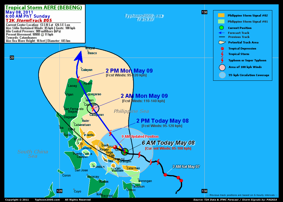
RECENT MULTI-AGENCY TROPICAL CYCLONE FORECAST TRACKING CHART:


> Image source: NOAA SATELLITE CENTER: http://www.ssd.noaa.gov/mtsat/flt/t1/rgb.jpg
> Image source: Wunderground.com Tropical Page (http://www.wunderground.com/tropical)
____________________________________________________________________________________________________________________
LATEST 24 HR. TOTAL RAINFALL AMOUNTS / ENSEMBLE TROPICAL RAINFALL POTENTIAL (eTRaP):

> Image source: NOAA Satellite & Information Service (http://www.ssd.noaa.gov/PS/TROP/etrap.html)
>> To know the meteorological terminologies and acronyms used on this update visit the ff:
http://typhoon2000.ph/tcterm.htm
http://www.nhc.noaa.gov/aboutgloss.shtml
http://www.srh.noaa.gov/oun/severewx/glossary.php
http://www.srh.weather.gov/fwd/glossarynation.html
http://www.nhc.noaa.gov/acronyms.shtml
__________________________________________________________________________________________
For the complete details on TS AERE (BEBENG)...go visit our website @:
> http://www.typhoon2000.com
> http://www.maybagyo.com
Copyright © 2011 Typhoon2000.com All Rights Reserved

No comments:
Post a Comment