
for Tuesday, 24 May 2011 [7:00 AM PhT]![]()

<<<Typhoon2000.com Mobile >>>
Get the latest 6-hrly SMS Storm Alerts on CHEDENG!
For more details: Text T2K TYPHOON to
2800 (Globe/TM) | 216 (Smart/TNT) | 2288 (Sun)
*Only P2.50 (Smart/Globe) / P2.00 (Sun) per msg received.
Click here on how to use this service (in PDF file)
Powered by: Synermaxx Corporation
Typhoon2000 (T2K) NEWS (Monday May 23 2011):
Currently issuing 6-hrly web, twitter, SMS and e-mail updates (except 12 AM) on TS SONGDA (CHEDENG).
SONGDA (CHEDENG) MAX WIND SPEED PER AGENCY:
+ USA (JTWC/1-min avg): 100 km/hr
+ Philippines (PAGASA/10-min avg): 105 km/hr
+ Japan (JMA/10-min avg): 100 km/hr
+ Korea (KMA/10-min avg): 110 km/hr
+ Taiwan (CWB/10-min avg): 105 km/hr
+ Beijing (NMC/2-min avg): 100 km/hr
+ Hong Kong (HKO/10-min avg): 95 km/hr
:: Click here to see Multi-Agency Forecast Tracks
TROPICAL STORM SONGDA [CHEDENG/04W/1102]
T2K PUBLIC ADVISORY NUMBER 012
6:00 AM PhT (22:00 GMT) Tue 24 May 2011
Sources: T2K Extrap Analysis/JTWC Warning #015/SatFixes
View: Advisory Archives (2004-2011)
Tropical Storm SONGDA (CHEDENG) has slowed down over the Philippine Sea...nears Typhoon strength.
Residents and visitors along the Eastern Coast of Luzon, Bicol Region & Eastern Visayas should closely monitor the progress of SONGDA (CHEDENG).
Do not use this for life or death decision. This advisory is intended for additional information purposes only. Kindly refer to your country's official weather agency for local warnings, advisories & bulletins.
CURRENT STORM INFORMATION
Time/Date: 6:00 AM PhT Tue May 24 2011
Location of Center: 11.8º N Lat 131.2º E Lon
Distance 1: 630 km (340 nm) ENE of Borongan City
Distance 2: 720 km (390 nm) ESE of Catarman, N.Samar
Distance 3: 785 km (425 nm) ESE of Virac, Catanduanes
Distance 4: 795 km (430 nm) ESE of Sorsogon City
Distance 5: 825 km (445 nm) ESE of Legazpi City
Distance 6: 890 km (480 nm) ESE of Metro Naga/CWC
MaxWinds (1-min avg): 110 kph (60 kts) near the center
Peak Wind Gusts: 140 kph (75 kts)
Present Movement: WNW @ 11 kph (06 kts)
Towards: Cagayan's East Coast
CPA near Bicol Coast: 2PM Wed-2PM Thu
24hr Rainfall Accum (near center): 520 mm (Very High)
Rainrate (near center): 20-30 mm/hr (Mod-Heavy) new!
Minimum Central Pressure: 978 millibars (hPa)
Saffir-Simpson Typhoon Scale: TS
Size (in Diameter): 480 km (260 nm) / Average
Max Sea Wave Height (near center): 22 ft (6.7 m)
Possible Storm Surge Height: 0-3 ft [0-0.9 m]
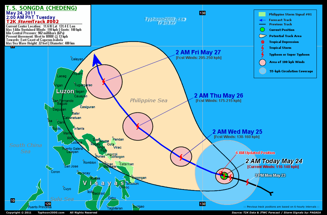
T2K TrackMap (for Public): 6:00 AM PhT Tue May 24
FORECAST OUTLOOK ANALYSIS (up to 48 hours)* EXTENDED FORECAST TRACK (3 to 5 days)*
SONGDA (CHEDENG) is expected to continue intensifying while maintaining its WNW track across the Philippine Sea within the next 2 days. The storm is likely to be upgraded to a Category 1 Typhoon early tomorrow and move closer to the coast of Bicol Region particularly Catanduanes [2PM MAY 24: 12.1N 130.1E @ 110kph...2AM MAY 25: 12.8N 128.6E @ 130kph]. As SONGDA passes to the NE of Bicol Region - it will therefore gain more strength - becoming a Category 2 Typhoon by Thursday early morninig (May 26)...about 185 km NE of Guigmoto, Catanduanes [2PM MAY 25: 13.7N 127.1E @ 150kph...2AM MAY 26: 14.8N 125.8E @ 175kph]. SONGDA's (CHEDENG) closest approach (CPA) to Catanduanes shall be about 185 km NE of Pandan or 220 km NE of Virac between 2-4AM on Thursday (May 26). While its closest approach (CPA) to Camarines Sur shall be about 220 km NE of Caramoan or 285 km NE of Metro Naga between 5-8AM Thursday.
Maximum Sustained Winds (1-min. avg) are near 110 km/hr (60 knots) with higher gusts. SONGDA (CHEDENG) is a strong Tropical Storm (TS) on the Saffir-Simpson Tropical Cyclone Scale. Tropical Storm Force Winds (62-117 km/hr) extend outward up to 175 kilometers (95 nautical miles) from the center. SONGDA is an average-sized tropical cyclone with a diameter of 480 kilometers (260 nautical miles).  FRIDAY EARLY MORNING: Upgraded to Category 3 as it turns more NNW, passing near the east coast of Isabela & Cagayan (Northern Luzon)...about 200 km East of Tuguegarao City [2AM MAY 27: 17.7N 123.6E @ 205kph]. SATURDAY EARLY MORNING: Upgraded to Category 4 as it starts to recurve towards the North, while passing close to the Batanes Group of Islands...about 85 km NE of Basco, Batanes [2AM MAY 28: 21.0N 122.6E @ 215kph]. SUNDAY EARLY MORNING: Exiting the Philippine Area of Responsibility (PAR) after completing its recurvature...accelerating northeastward towards Okinawa-Ryukyu Islands...about 95 km NE of Ishigaki Island [2AM MAY 29: 25.1N 124.9E @ 195kph].
*Please be reminded that the Forecast Outlook changes every 6 hours, and the Extended Forecast Track have an average error of 250 km on Day 3...450 km on Day 4...and 650 km on Day 5, while the wind speed forecast error, averages 35 kph per day. Therefore, a turn to the left or right of its future track and changes in its wind speed must be anticipated from time to time.
EFFECTS & HAZARDS SUMMARY
SONGDA's CDO continues to organize near its center, with improved symmetrical circulation. Latest satellite imagery continues to show a banding eye - a sign that the system is nearing typhoon strength. Below are the summary of the storm's parts and its hazards affecting specific areas: CENTRAL DENSE OVERCAST (CDO) - remains over water (Philippine Sea). Tropical Storm Conditions w/ moderate to strong winds (62-117 kph) will be expected along the CDO. (click here to know more about CDO). INNER RAINBANDS - remains over water...not affecting any islands. Tropical Depression Conditions w/ moderate to strong winds (30-61 kph) will continue to prevail along these bands until tonight. OUTER RAINBANDS - over water...no longer affecting Western Micronesia - light to moderate winds (<30 kph) will be expected along these bands. (click here to know more about Rainbands). 24HR TOTAL RAINFALL ACCUMULATION - from 5 up to 290 mm (low to high rainfall) can be expected along the outer & inner rainbands...with isolated amounts of up to 520 mm (very high) near the center of SONGDA. [click to open NOAA's eTRaP graphic].
CURRENT I.T.C.Z. (MONSOON TROUGH) INTENSITY: STRONG >> Partly sunny to mostly cloudy with scattered to widespread showers, rains & thunderstorms will prevail along the following affected areas: SOUTHERN LUZON, BICOL REGION, VISAYAS & MINDANAO. Light to moderate SE to variable winds (not in excess of 35 kph) will be expected.
Important Note: Please keep in mind that the above forecast outlook, extended forecast, effects-hazards, current monsoon intensity, & tropical cyclone watch changes every 6 to 12 hrs!
JTWC (US NAVY & AIR FORCE) REMARKS:
REMARKS (for Meteorologists): 2 AM (18 GMT) TUE 24 MAY POSITION: 11.6N 131.4E.
*TROPICAL STORM (TS) 04W (SONGDA), LOCATED APPROXIMATELY 630 NM EAST-
SOUTHEAST OF MANILA, PHILIPPINES, HAS TRACKED WEST-NORTHWESTWARD AT
07 KNOTS OVER THE PAST SIX HOURS. ANIMATED WATER VAPOR IMAGERY SHOWS
EXCELLENT OUTFLOW ALONG THE NORTHEAST PERIPHERY OF THE SYSTEM.
HOWEVER, AN UPPER LEVEL TROUGH ALONG THE NORTHWEST QUADRANT IS
CAUSING SUBSIDENCE AND IMPINGING OVERALL DEVELOPMENT. THE INITIAL
POSITION IS EXTRAPOLATED FROM ALL AVAILABLE METSAT IMAGERY AND A
NEARBY SHIP OBSERVATION TO THE NORTH. THE INITIAL INTENSITY IS BASED
ON DVORAK ESTIMATES RANGING FROM 40 TO 65 KNOTS FROM PGTW, KNES, AND
RJTD. TS O4W IS JUST TO THE SOUTH OF AN UPPER LEVEL RIDGE IN AN AREA
OF WEAK VERTICAL WIND SHEAR (VWS). THE CYCLONE IS BEING STEERED
ALONG THE SOUTHWEST PERIPHERY OF A DEEP-LAYERED SUBTROPICAL RIDGE TO
THE NORTHEAST. IT IS EXPECTED TO TRACK AND DEVELOP SLOWLY OVER THE
NEXT 24 HOURS UNTIL THE AFOREMENTIONED TROUGH PASSES TO THE EAST. BY
TAU 36 AS VWS FURTHER RELAXES, TS SONGDA WILL COMMENCE RAPID
INTENSIFICATION OVER THE WARM PHILIPPINE SEA, EXCEEDING TYPHOON
STRENGTH AS IT APPROACHES THE WESTERN EDGE OF THE STEERING RIDGE,
PEAKING AT 115 KNOTS BEFORE RECURVING TOWARDS JAPAN. THIS
RECURVATURE WILL BE INITIATED BY A MID-LATITUDE TROUGH APPROACHING
FROM THE NORTHWEST AND CURRENTLY OVER EASTERN CHINA. THE AVAILABLE
NUMERICAL GUIDANCE IS IN TIGHT AGREEMENT WITH WITH THIS TRACK
FORECAST WITH NOGAPS AS THE LEFT OUTLIER, TAKING THE VORTEX INLAND
OVER THE NORTHEASTERN TIP OF LUZON BEFORE RECURVATURE...(more)
>> SONGDA, meaning: A river in northwestern Viet Nam. Name contributed by:Viet Nam.
_______________________________________________________________________________________________________________________________________
RECENT TYPHOON2000.COM TRACKING CHART:
_________________________________________________________________________________________________________________
RECENT MULTI-AGENCY TROPICAL CYCLONE FORECAST TRACKING CHART: 

> Image source: NOAA SATELLITE CENTER: http://www.ssd.noaa.gov/mtsat/flt/t1/rgb.jpg
> Image source: Wunderground.com Tropical Page (http://www.wunderground.com/tropical)
____________________________________________________________________________________________________________________
LATEST 24 HR. TOTAL RAINFALL AMOUNTS / ENSEMBLE TROPICAL RAINFALL POTENTIAL (eTRaP):

> Image source: NOAA Satellite & Information Service (http://www.ssd.noaa.gov/PS/TROP/etrap.html)
>> To know the meteorological terminologies and acronyms used on this update visit the ff:
http://typhoon2000.ph/tcterm.htm
http://www.nhc.noaa.gov/aboutgloss.shtml
http://www.srh.noaa.gov/oun/severewx/glossary.php
http://www.srh.weather.gov/fwd/glossarynation.html
http://www.nhc.noaa.gov/acronyms.shtml
__________________________________________________________________________________________
For the complete details on TS SONGDA (CHEDENG)...go visit our website @:
> http://www.typhoon2000.com
> http://www.maybagyo.com
Copyright © 2011 Typhoon2000.com All Rights Reserved

No comments:
Post a Comment