Monday, July 31, 2006

TD 07W (HENRY) making landfall...[Update #06]


Typhoon2000 STORM UPDATE #06
Name: TROPICAL DEPRESSION 07W [HENRY] 
Issued: 7:00 PM MANILA TIME (11:00 GMT) MON 31 JULY 2006
Next Update: 7:00 AM (23:00 GMT) TUE 01 AUGUST 2006
Source: JTWC TROPICAL CYCLONE WARNING #002
_______________________________________________________________________
 
 
TROPICAL DEPRESSION 07W (HENRY) INTENSIFIED SLIGHTLY
AS IT IS ABOUT TO MAKE LANDFALL OFF THE SOUTHERN PART
OF ISABELA, JUST NORTH OF CASIGURAN, AURORA...TO CROSS
NORTHERN LUZON THRU THE NIGHT. RAINBANDS COVERING THE
WHOLE OF LUZON WITH THE HELP OF THE ENHANCED SOUTHWEST
MONSOON.


+ FORECAST OUTLOOK: 07W is expected to cross the provinces
of Isabela tonight passing over Ifugao and shall be in the
vicinity of Mountain Province-Kalinga-Abra Border around 2
AM tomorrow morning (Aug 1). The depression shall be over
Vigan, Ilocos Sur around 7 AM tomorrow morning before mo-
ving out into the South China Sea. The 3 to 4-day Long
Range Forecast shows the system becoming a strong 95-km/hr
Tropical Storm over the South China Sea moving in the di-
rection of Southern China and making its 2nd landfall over
Western Guangdong around Friday morning (Aug 4).


+ EFFECTS: 07W's rainbands continues to affect the whole
of Luzon including Metro Manila, becoming more frequent
along the provinces of Isabela, Ifugao, Mt. Province, Ka-
linga, Abra, Ilocos Sur, Benguet, Nueva Vizcaya, Nueva
Ecija, Pangasinan, Zambales & La Union. These bands will
continue to bring cloudy skies with scattered moderate to
sometimes heavy rains. Residents living along river banks,
steep mountain slopes and low-lying areas are advised to
stay alert and foresee evacuation for possible flashfloods
and mudslides.
People living around the slopes of Mayon
Volcano in Albay especially along the area where possible
LAHAR FLOWS (mixture of volcanic mud and water) are loca-
ted - must stay on alert at all times for immediate eva-
cuation.

+ CURRENT MONSOON INTENSITY: Weak to Moderate Southwest
(SW) Monsoon continues to affect the western sections of
Visayas including Palawan, Boracay Island Resort, Romblon,
Marinduque, Lubang Island, Sulu Sea, and Mindoro. Cloudy
weather conditions with light to moderate or sometimes
heavy rainfall can be expected today. Southwesterly winds
of 30 km/hr with higher gusts may be expected along the
affected areas.

Important Note: Please keep in mind that the above forecast
outlook, effects, current monsoon intensity, and tropical
cyclone watch changes every 06 to 12 hours!
_______________________________________________________________________

TIME/DATE: 5:00 PM MANILA TIME (09:00 GMT) 31 JULY
LOCATION OF CENTER: LATITUDE 16.4º N...LONGITUDE 122.5º E
DISTANCE 1: 50 KM (27 NM) NE OF CASIGURAN, AURORA, PH
DISTANCE 2: 205 KM (110 NM) EAST OF BAGUIO CITY, PH
DISTANCE 3: 260 KM (140 NM) SE OF VIGAN CITY, PH
DISTANCE 4: 160 KM (85 NM) SSE OF TUGUEGARAO CITY, PH
MAX SUSTAINED WINDS [1-MIN AVG]: 55 KM/HR (30 KTS)
PEAK WIND GUSTS: 75 KM/HR (40 KTS)
MINIMUM CENTRAL PRESSURE (est.): 1000 MILLIBARS (hPa)
MAX WAVE HEIGHT**: 11 FEET (3.3 METERS)
SAFFIR-SIMPSON SCALE: N/A
RECENT MOVEMENT: NW @ 20 KM/HR (11 KTS)
GENERAL DIRECTION: AURORA-ISABELA AREA
STORM'S SIZE (IN DIAMETER): 555 KM (300 NM)/AVERAGE
VIEW T2K TRACKING MAP: 5 PM MON JULY 31

PHILIPPINE STORM SIGNALS*:
#01 -
AURORA, QUIRINO, NUEVA VIZCAYA, NUEVA ECIJA, 
      ISABELA, CAGAYAN, KALINGA, APAYAO, MT. PROVINCE, 
      IFUGAO, BENGUET, ILOCOS PROVINCES, LA UNION, ABRA, 
      PANGASINAN, TARLAC AND ZAMBALES.

           
12, 24 & 48 HR. FORECAST:
> 2 AM (18 GMT) 01 AUGUST: 17.3N 121.1E / 55-75 KPH
> 2 PM (06 GMT) 01 AUGUST: 18.1N 119.3E / 65-85 KPH
> 2 PM (06 GMT) 02 AUGUST: 19.6N 114.9E / 85-100 KPH

REMARKS: 2 PM (06 GMT) 31 JULY POSITION: 16.4N 122.6E.
^TD 07W IS FORECAST TO REMAIN A MINIMAL DEPRESSION OVER
THE NEXT 24 HOURS. INTERACTION WITH THE ISLAND OF LUZON
WILL LIMIT STRENGTHENING IN THE NEAR TERM. PAST 24
HOURS, DECREASING VERTICAL WIND SHEAR AND OPEN WARM
WATER WILL ALLOW FOR A REORGINIZATION AND GRADUAL
STRENGTHENING. THE SYSTEM SHOULD ALSO GET GOOD
OUTFLOW IN THE EQUATORWARD DIRECTION
...(more info)
_________________________________________________________________________________

PAGASA CURRENT POSITION, MOVEMENT AND INTENSITY (10-min. ave.): 
> 4 PM (08 GMT) 31 JULY: 16.6N 121.5E / WNW @ 13 KPH / 55 kph

:: For the complete PAGASA bulletin, kindly visit their website 
   at:
http://www.pagasa.dost.gov.ph/wb/tcupdate.shtml
_________________________________________________________________________________
 
LATEST T2K TRACKING CHART:


_______________________________________________________________________________________

RECENT MTSAT-1R SATELLITE IMAGE:
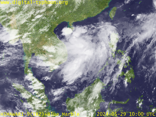

> Image source:  Digital-Typhoon.org (Nat'l. Institute of Informatics, Japan) (http://www.digital-typhoon.org)
__________________________________________________________________________________________

NOTES:
 
  ^ - JTWC commentary remarks (for Meteorologists) from their 
      latest warning.
 
  * - Based on PAGASA's Philippine Storm Warning Signals, 
      # 4 being the highest. Red letters indicate new areas 
      being hoisted.
For more explanations on these signals, 
      visit: 
http://www.typhoon2000.ph/signals.htm

 ** - Based on the Tropical Cyclone's Sea Wave Height near 
      its center.

__________________________________________________________________________________________

>>
To know the meteorological terminologies and acronyms 
   used on this update visit the ff:

    http://typhoon2000.ph/tcterm.htm  
    http://www.nhc.noaa.gov/aboutgloss.shtml
    http://www.srh...........noaa.gov/oun/severewx/glossary.php
    http://www.srh.weather.gov/fwd/glossarynation.html
    http://www.nhc.noaa.gov/acronyms.shtml
__________________________________________________________________________________________

:: Typhoon2000.com (T2K) Mobile >> Powered by: Synermaxx
Receive the latest storm updates directly to your mobile phones! To know more:
Send T2K HELP to: 2800
(GLOBE & TM) | 216 (SMART & TNT) | 2288 (SUN)
 
__________________________________________________________________________________________

For the complete details on the TD 07W (HENRY)...go visit
our website @:

>
http://www.typhoon2000.com
http://www.maybagyo.com

:: Kindly view our site's disclaimer at: 
   
http://www.typhoon2000.ph/disclaimer.htm


__._,_.___
Recent Activity
Visit Your Group
SPONSORED LINKS
Travel Deals

Yahoo! FareChase

The best way to

find low fares

Yahoo! Groups

Start a group

in 3 easy steps.

Connect with others.

Y! Toolbar

Get it Free!

easy 1-click access

to your groups.

.

__,_._,___

Sunday, July 30, 2006

TD HENRY passing North of Catanduanes...[Update #04]


Typhoon2000 STORM UPDATE #04
Name: TROPICAL DEPRESSION HENRY [96W] 
Issued: 7:00 PM MANILA TIME (11:00 GMT) SUN 30 JULY 2006
Next Update: 7:00 AM (23:00 GMT) MON 31 JULY 2006
Source: PAGASA BULLETIN-WARNING #008
_______________________________________________________________________
 
 
TROPICAL DEPRESSION HENRY (96W) CONTINUES TO DRIFT WEST-
NORTHWEST TOWARDS LUZON
...PASSING NORTH OF CATANDUANES...
RAINBANDS AFFECTING CENTRAL AND SOUTHERN LUZON INCLU-
DING NORTHERN VISAYAS.

+ FORECAST OUTLOOK: HENRY is expected to move WNW for the
next 24 hours and shall make landfall along Aurora or in
the vicinity of Casiguran early Tuesday morning (Aug 1).
It shall then cross Northern Luzon until Wednesday eve-
ning. The 3-day forecast (72 hours) shows the system over
the Apayao-Kalinga-Ilocos area by Wednesday afternoon
(Aug 2).


+ EFFECTS: HENRY's western & southern rainbands continues
to affect Bicol Region, Masbate, Samar & Leyte Provinces,
Mindoro, Quezon Provinces and Northern Visayas. The rain-
bands is now beginning to spread across Central & Sou-
thern Luzon. These bands will continue to bring cloudy
skies with scattered moderate to sometimes heavy rains.
Residents living along river banks, steep mountain slopes
and low-lying areas are advised to stay alert and foresee
evacuation for possible flashfloods and mudslides. People
living around the slopes of Mayon Volcano in Albay espe-
cially along the area where possible LAHAR FLOWS (mixture
of volcanic mud and water) are located - must stay on
alert at all times for immediate evacuation.

+ CURRENT MONSOON INTENSITY: Weak to Moderate Southwest
(SW) Monsoon continues to affect the western sections of
Mindanao & Visayas including Palawan. Cloudy weather con-
ditions with light to moderate or sometimes heavy rainfall
can be expected tonight and tomorrow. Southwesterly winds
of 30 km/hr with higher gusts may be expected along the
affected areas.

Important Note: Please keep in mind that the above forecast
outlook, effects, current monsoon intensity, and tropical
cyclone watch changes every 06 to 12 hours!
_______________________________________________________________________

TIME/DATE: 4:00 PM MANILA TIME (08:00 GMT) 30 JULY
LOCATION OF CENTER: LATITUDE 15.0º N...LONGITUDE 124.4º E
DISTANCE 1: 155 KM (83 NM) NORTH OF VIRAC, CATANDUANES, PH
DISTANCE 2: 200 KM (108 NM) NE OF NAGA CITY, PH
DISTANCE 3: 280 KM (150 NM) ESE OF CASIGURAN, AURORA, PH
DISTANCE 4: 290 KM (157 NM) ENE OF INFANTA, QUEZON, PH
MAX SUSTAINED WINDS [10-MIN AVG]: 55 KM/HR (30 KTS)
PEAK WIND GUSTS: 70 KM/HR (38 KTS)
MINIMUM CENTRAL PRESSURE (est.): 1000 MILLIBARS (hPa)
MAX WAVE HEIGHT**: 06 FEET (1.8 METERS)
SAFFIR-SIMPSON SCALE: N/A
RECENT MOVEMENT: WNW @ 07 KM/HR (04 KTS)
GENERAL DIRECTION: CENTRAL AND NORTHERN LUZON
STORM'S SIZE (IN DIAMETER): 555 KM (300 NM)/AVERAGE
VIEW T2K TRACKING MAP: 4 PM SUN JULY 30

PHILIPPINE STORM SIGNALS*:
#01 -
CAMARINES NORTE, CAMARINES SUR, ALBAY, CATANDUANES,
      AURORA, QUEZON AND POLILLO ISLAND.

           
24-48 HR. FORECAST:
> 2 PM (06 GMT) 31 JULY: 15.6N 123.0E
> 2 PM (06 GMT) 01 AUGUST: 16.7N 121.6E

REMARKS: 2 PM (06 GMT) 30 JULY POSITION: 15.0N 124.5E.

_________________________________________________________________________________
_________________________________________________________________________________
 
LATEST T2K TRACKING CHART:


_______________________________________________________________________________________

RECENT MTSAT-1R SATELLITE IMAGE:


> Image source:  Digital-Typhoon.org (Nat'l. Institute of Informatics, Japan) (http://www.digital-typhoon.org)
__________________________________________________________________________________________

NOTES:
 
  ^ - JTWC commentary remarks (for Meteorologists) from their 
      latest warning.
 
  * - Based on PAGASA's Philippine Storm Warning Signals, 
      # 4 being the highest. Red letters indicate new areas 
      being hoisted.
For more explanations on these signals, 
      visit: 
http://www.typhoon2000.ph/signals.htm

 ** - Based on the Tropical Cyclone's Sea Wave Height near 
      its center.

__________________________________________________________________________________________

>>
To know the meteorological terminologies and acronyms 
   used on this update visit the ff:

    http://typhoon2000.ph/tcterm.htm  
    http://www.nhc.noaa.gov/aboutgloss.shtml
    http://www.srh..........noaa.gov/oun/severewx/glossary.php
    http://www.srh.weather.gov/fwd/glossarynation.html
    http://www.nhc.noaa.gov/acronyms.shtml
__________________________________________________________________________________________

:: Typhoon2000.com (T2K) Mobile >> Powered by: Synermaxx
Receive the latest storm updates directly to your mobile phones! To know more:
Send T2K HELP to: 2800
(GLOBE & TM) | 216 (SMART & TNT) | 2288 (SUN)
 
__________________________________________________________________________________________

For the complete details on the TD HENRY (96W)...go visit
our website @:

>
http://www.typhoon2000.com
http://www.maybagyo.com

:: Kindly view our site's disclaimer at: 
   
http://www.typhoon2000.ph/disclaimer.htm


__._,_.___
Recent Activity
Visit Your Group
SPONSORED LINKS
Travel Deals

Yahoo! FareChase

Find great prices

on hotel rooms

Yahoo! Groups

Start a group

in 3 easy steps.

Connect with others.

Y! Toolbar

Get it Free!

easy 1-click access

to your groups.

.

__,_._,___

HENRY's rainbands affecting Bicol Region...[Update #03]


Typhoon2000 STORM UPDATE #03
Name: TROPICAL DEPRESSION HENRY [96W] 
Issued: 7:00 AM MANILA TIME (23:00 GMT) SUN 30 JULY 2006
Next Update: 7:00 PM (11:00 GMT) SUN 30 JULY 2006
Source: PAGASA BULLETIN-WARNING #006
_______________________________________________________________________
 
 
TROPICAL DEPRESSION HENRY (96W) HAS SLIGHTLY ACCELERATED
WEST-NORTHWESTWARD AND IS NOW EYEING CENTRAL AND NOR-
THERN LUZON...WESTERN RAINBANDS AFFECTING THE WHOLE
BICOL REGION, SOUTHERN QUEZON, NORTHERN AND EASTERN
VISAYAS
.

+ FORECAST OUTLOOK: HENRY is expected to move WNW for the
next 2 days and shall make landfall along Aurora-Isabela
or just to the north of Casiguran tomorrow noontime (Mon,
Jul 31). It shall then cross Northern Luzon tomorrow late
afternoon before moving out into the South China Sea via
Ilocos Sur around early Tuesday morning (Aug 1). The 3-
day forecast (72 hours) shows the system over South China
Sea moving towards Guangdong-Hong Kong area.


+ EFFECTS: HENRY's western rain bands continues to affect
Bicol Region, Masbate, Samar & Leyte Provinces and is now
spreading across Southern Quezon and Northern Visayas.
These bands will continue to bring cloudy skies with sca-
ttered moderate to sometimes heavy rains. Residents li
ving along river banks, steep mountain slopes and low-
lying areas are advised to stay alert and foresee evacua-
tion for possible flashfloods and mudslides. People li-
ving around the slopes of Mayon Volcano in Albay especia-
lly along the area where possible LAHAR FLOWS (mixture of
volcanic mud and water) are located - must stay on alert
at all times for immediate evacuation.

+ CURRENT MONSOON INTENSITY: Weak to Moderate Southwest
(SW) Monsoon continues to affect the western sections of
Mindanao & Visayas including Palawan. Cloudy weather con-
ditions with light to moderate or sometimes heavy rain-
fall can be expected tonight and tomorrow. Southwesterly
winds of 30 km/hr with higher gusts may be expected
along the affected areas.

Important Note: Please keep in mind that the above forecast
outlook, effects, current monsoon intensity, and tropical
cyclone watch changes every 06 to 12 hours!
_______________________________________________________________________

TIME/DATE: 4:00 AM MANILA TIME (20:00 GMT) 30 JULY
LOCATION OF CENTER: LATITUDE 14.5º N...LONGITUDE 126.1º E
DISTANCE 1: 220 KM (120 NM) NE OF VIRAC, CATANDUANES, PH
DISTANCE 2: 330 KM (180 NM) ENE OF NAGA CITY, PH
DISTANCE 3: 300 KM (162 NM) NE OF LEGAZPI CITY, PH
DISTANCE 4: 350 KM (190 NM) ENE OF DAET, CAM. NORTE, PH
MAX SUSTAINED WINDS [10-MIN AVG]: 55 KM/HR (30 KTS)
PEAK WIND GUSTS: 70 KM/HR (38 KTS)
MINIMUM CENTRAL PRESSURE (est.): 1000 MILLIBARS (hPa)
MAX WAVE HEIGHT**: 06 FEET (1.8 METERS)
SAFFIR-SIMPSON SCALE: N/A
RECENT MOVEMENT: WNW @ 15 KM/HR (08 KTS)
GENERAL DIRECTION: CENTRAL AND NORTHERN LUZON
STORM'S SIZE (IN DIAMETER): 555 KM (300 NM)/AVERAGE
VIEW T2K TRACKING MAP: 4 AM SUN JULY 30

PHILIPPINE STORM SIGNALS*:
#01 -
CAMARINES NORTE, CAMARINES SUR, ALBAY, SORSOGON 
      & CATANDUANES.

           
24-48 HR. FORECAST:
> 2 AM (18 GMT) 31 JULY: 15.9N 123.6E
> 2 AM (18 GMT) 01 AUGUST: 17.4N 120.5E

REMARKS: 2 AM (18 GMT) 30 JULY POSITION: 14.3N 126.4E.

_________________________________________________________________________________
_________________________________________________________________________________
 
LATEST T2K TRACKING CHART:


_______________________________________________________________________________________

RECENT MTSAT-1R SATELLITE IMAGE:


> Image source:  Digital-Typhoon.org (Nat'l. Institute of Informatics, Japan) (http://www.digital-typhoon.org)
__________________________________________________________________________________________

NOTES:
 
  ^ - JTWC commentary remarks (for Meteorologists) from their 
      latest warning.
 
  * - Based on PAGASA's Philippine Storm Warning Signals, 
      # 4 being the highest. Red letters indicate new areas 
      being hoisted.
For more explanations on these signals, 
      visit: 
http://www.typhoon2000.ph/signals.htm

 ** - Based on the Tropical Cyclone's Sea Wave Height near 
      its center.

__________________________________________________________________________________________

>>
To know the meteorological terminologies and acronyms 
   used on this update visit the ff:

    http://typhoon2000.ph/tcterm.htm  
    http://www.nhc.noaa.gov/aboutgloss.shtml
    http://www.srh..........noaa.gov/oun/severewx/glossary.php
    http://www.srh.weather.gov/fwd/glossarynation.html
    http://www.nhc.noaa.gov/acronyms.shtml
__________________________________________________________________________________________

:: Typhoon2000.com (T2K) Mobile >> Powered by: Synermaxx
Receive the latest storm updates directly to your mobile phones! To know more:
Send T2K HELP to: 2800
(GLOBE & TM) | 216 (SMART & TNT) | 2288 (SUN)
 
__________________________________________________________________________________________

For the complete details on the TD HENRY (96W)...go visit
our website @:

>
http://www.typhoon2000.com
http://www.maybagyo.com

:: Kindly view our site's disclaimer at: 
   
http://www.typhoon2000.ph/disclaimer.htm


__._,_.___
Recent Activity
Visit Your Group
SPONSORED LINKS
Yahoo! Travel

View Travel Guides

Things to do in

40,000+ cities

Yahoo! Groups

Start a group

in 3 easy steps.

Connect with others.

Y! Toolbar

Get it Free!

easy 1-click access

to your groups.

.

__,_._,___

Saturday, July 29, 2006

TD HENRY almost stationary east of Bicol...[Update #02]


Typhoon2000 STORM UPDATE #02
Name: TROPICAL DEPRESSION HENRY [96W] 
Issued: 7:00 PM MANILA TIME (11:00 GMT) SAT 29 JULY 2006
Next Update: 7:00 AM (23:00 GMT) SUN 30 JULY 2006
Source: PAGASA BULLETIN-WARNING #004
_______________________________________________________________________
 
 
TROPICAL DEPRESSION HENRY (96W) HAS REMAINED ALMOST
STATIONARY 12 HOURS AGO AND IS NOW DRIFTING WEST-
NORTHWEST TOWARDS BICOL REGION
..NEW CLOUD CLUSTER
GROWING RAPIDLY NEAR ITS POORLY-DEFINED CENTER.

+ FORECAST OUTLOOK: HENRY is expected to move slowly WNW
for the next 2 days, passing close to the Northern Coast
of Catanduanes & Camarines Norte. 3-day forecast (72
hours) shows the system approaching Polillo Islands around
Tuesday afternoon (Aug 1). HENRY may intensify into a
Tropical Storm if the strong upper-level winds (wind
shear) above it weakens.


+ EFFECTS: HENRY's disorganized western outer bands con-
tinues to spread across Bicol Region and Samar Provinces,
bringing cloudy skies with scattered moderate to sometimes
heavy rains. Residents living along river banks, steep
mountain slopes and low-lying areas are advised to stay
alert and foresee evacuation for possible flashfloods and
mudslides. People living around the slopes of Mayon Vol-
cano in Albay especially along the area where possible
LAHAR FLOWS (mixture of volcanic mud and water) are
located - must stay on alert at all times for immediate
evacuation.

+ CURRENT MONSOON INTENSITY: Weak to Moderate Southwest
(SW) Monsoon continues to affect Mindanao especially the
western sections & is now spreading across Western Visa-
yas. Cloudy weather conditions with light to moderate &
sometimes heavy rainfall can be expected tonight and to-
morrow. Southwesterly winds of 30 km/hr with higher
gusts may be expected along the affected areas.

Important Note: Please keep in mind that the above forecast
outlook, effects, current monsoon intensity, and tropical
cyclone watch changes every 06 to 12 hours!
_______________________________________________________________________

TIME/DATE: 4:00 PM MANILA TIME (08:00 GMT) 29 JULY
LOCATION OF CENTER: LATITUDE 13.2º N...LONGITUDE 127.4º E
DISTANCE 1: 315 KM (170 NM) ENE OF CATARMAN, N. SAMAR, PH
DISTANCE 2: 400 KM (215 NM) EAST OF LEGAZPI CITY, PH
DISTANCE 3: 340 KM (185 NM) ESE OF VIRAC, CATANDUANES, PH
DISTANCE 4: 455 KM (245 NM) ESE OF NAGA CITY, PH
MAX SUSTAINED WINDS [10-MIN AVG]: 55 KM/HR (30 KTS)
PEAK WIND GUSTS: 70 KM/HR (38 KTS)
MINIMUM CENTRAL PRESSURE (est.): 1000 MILLIBARS (hPa)
MAX WAVE HEIGHT**: 06 FEET (1.8 METERS)
SAFFIR-SIMPSON SCALE: N/A
RECENT MOVEMENT: WNW @ 07 KM/HR (04 KTS)
GENERAL DIRECTION: BICOL REGION-QUEZON AREA
STORM'S SIZE (IN DIAMETER): 555 KM (300 NM)/AVERAGE
VIEW T2K TRACKING MAP: 4 PM SAT JULY 29

PHILIPPINE STORM SIGNALS*:
#01 -
CAMARINES NORTE, CAMARINES SUR, ALBAY, SORSOGON 
      & CATANDUANES.

           
24-48 HR. FORECAST:
> 2 PM (06 GMT) 30 JULY: 13.5N 126.0E
> 2 PM (06 GMT) 31 JULY: 14.4N 124.7E

REMARKS: 2 PM (06 GMT) 29 JULY POSITION: 13.1N 127.6E.

_________________________________________________________________________________
_________________________________________________________________________________
 
LATEST T2K TRACKING CHART:


_______________________________________________________________________________________

RECENT MTSAT-1R SATELLITE IMAGE:


> Image source:  Digital-Typhoon.org (Nat'l. Institute of Informatics, Japan) (http://www.digital-typhoon.org)
__________________________________________________________________________________________

NOTES:
 
  ^ - JTWC commentary remarks (for Meteorologists) from their 
      latest warning.
 
  * - Based on PAGASA's Philippine Storm Warning Signals, 
      # 4 being the highest. Red letters indicate new areas 
      being hoisted.
For more explanations on these signals, 
      visit: 
http://www.typhoon2000.ph/signals.htm

 ** - Based on the Tropical Cyclone's Sea Wave Height near 
      its center.

__________________________________________________________________________________________

>>
To know the meteorological terminologies and acronyms 
   used on this update visit the ff:

    http://typhoon2000.ph/tcterm.htm  
    http://www.nhc.noaa.gov/aboutgloss.shtml
    http://www.srh.........noaa.gov/oun/severewx/glossary.php
    http://www.srh.weather.gov/fwd/glossarynation.html
    http://www.nhc.noaa.gov/acronyms.shtml
__________________________________________________________________________________________

:: Typhoon2000.com (T2K) Mobile >> Powered by: Synermaxx
Receive the latest storm updates directly to your mobile phones! To know more:
Send T2K HELP to: 2800
(GLOBE & TM) | 216 (SMART & TNT) | 2288 (SUN)
 
__________________________________________________________________________________________

For the complete details on the TD HENRY (96W)...go visit
our website @:

>
http://www.typhoon2000.com
http://www.maybagyo.com

:: Kindly view our site's disclaimer at: 
   
http://www.typhoon2000.ph/disclaimer.htm


__._,_.___
Recent Activity
Visit Your Group
SPONSORED LINKS
Take a Trip

Find Great Deals

Yahoo! Travel

makes it easy

Yahoo! Groups

Start a group

in 3 easy steps.

Connect with others.

Y! Toolbar

Get it Free!

easy 1-click access

to your groups.

.

__,_._,___