
for Saturday, 03 October 2009 [6:09 PM PST]


<<<Typhoon2000.com Mobile >>>
Get the latest 3-hrly SMS Storm Alerts on PEPENG!
For more details: Text T2K TYPHOON to
2800 (Globe/TM) | 216 (Smart/TNT) | 2288 (Sun)
*only P2.50 (Smart/Globe) / P2.00 (Sun) per msg received.
powered by: Synermaxx
Typhoon2000 (T2K) NEWS (Thu October 01 2009):
Currently issuing 6-hrly advisories (except 12:00 AM) on Typhoon PARMA (PEPENG).
PARMA (PEPENG) MAX WIND SPEED PER AGENCY:
+ Philippines (PAGASA/10-min avg): 175 km/hr
+ Beijing (NMC/2-min avg): 170 kph
+ Taiwan (CWB/10-min avg): 160 km/hr
+ Korea (KMA/10-min avg): 150 km/hr
+ USA (JTWC/1-min avg): 150 km/hr
+ Hong Kong (HKO/10-min avg): 145 km/hr
+ Japan (JMA/10-min avg): 140 km/hr
TYPHOON PARMA [PEPENG/19W/0917]
T2K PUBLIC ADVISORY NUMBER 017
6:00 PM PST (10:00 GMT) Sat 03 October 2009
Source: T2K ANALYSIS / JTWC WARNING #023
View: Advisory Archives (2004-2009)
Typhoon PARMA (PEPENG) now traversing Cagayan...typhoon conditions prevailing across Extreme Northern Luzon.
*Residents and visitors along Extreme Northern Luzon & Taiwan should closely monitor the progress of PARMA.
*Kindly refer to your local warnings & bulletins issued by your country's official weather agency. This advisory is intended for additional information purposes only.
+ Forecast Outlook: PARMA is expected to continue moving WNW for the next 12 hours across Extreme Northern Luzon and shall weaken, turning NW very slowly while along the coast of NW Cagayan, near Ilocos Norte tomorrow afternoon. .The 2 to 5-day Long-Range Forecast shows the system remaining quasi-stationary along the Balintang Channel from Sunday evening until Monday afternoon. PARMA shall begin drift ENE to East slowly across the Batanes Group on Monday afternoon...then accelerating further on Tuesday as it follows the much stronger Typhoon MELOR, which is interacting w/ this typhoon.Please be aware that long-range forecast changes every now and then. Continued monitoring on this potential typhoon is a must for disaster preparedness agencies.
+ Effects: PARMA's main circulation remains over Northern Luzon...Its core (eye & eyewall) is now making landfall over Cagayan...Typhoon conditions of winds not exceeding 185 kph can be expected along Cagayan and Apayao...while its inner (rain) bands spreading across the whole of Northern Luzon - where stormy conditions w/ winds not exceeding 100 kph. Central Luzon will be under PARMA's outer (feeder) bands), where moderate to heavy rains w/ winds not exceeding 60 kph can be expected. 1-day rainfall accumulations of 100 up to 200 mm (moderate to heavy rain) can be expected along PARMA's rainbands...with isolated accumulations of up to 400 mm (very heavy rain) near the center of PARMA. Residents in low-lying areas & steep slopes must remain alert & seek evacuation for possible life-threatening flash floods, mudslides & landslides due to the anticipated heavy rains brought about by this system. Precautionary measures must be initiated if necessary. Possible coastal Storm Surge flooding of 4 to 5 feet above normal tide levels...accompanied by large and dangerous battering waves...is possible along the coastal areas of Extreme Northern Luzon. Minimal damage is likely on this type of storm surge.
+ Tropical Cyclone Watch:
(1) Typhoon MELOR (20W) approaching the northernmost part of Marianas. Click here to view latest T2K advisory.
Kindly click the cool T2K Graphical Satellite Analysis, issued every afternoon, and shows various tropical systems roaming across the South China Sea and the Western Pacific Ocean.
[Important Note: Please keep in mind that the above forecast outlook, effects, current monsoon intensity, & tropical cyclone watch changes every 6 to 12 hrs!]
Time/Date: 6:00 PM PST Sat October 03 2009
Location of Eye: 18.1º N Lat 122.0º E Lon
Distance 1: 45 km (25 nm) SE of Aparri, Cagayan
Distance 2: 65 km (35 nm) NNE of Tuguegarao City
Distance 3: 150 km (80 nm) East of Laoag City
Distance 4: 145 km (78 nm) SSE of Calayan Island
Distance 5: 265 km (143 nm) South of Basco, Batanes
Distance 6: 400 km (215 nm) NNE of Metro Manila
MaxWinds (1-min avg): 150 kph (80 kts) near the eye
Peak Wind Gusts: 185 kph (100 kts)
Saffir-Simpson Typhoon Scale: Category 1
Coastal Storm Surge Height: 4-5 feet [1.2-1.7 m]
Minimum Central Pressure: 963 millibars (hPa)
Recent Movement: WNW @ 17 kph (09 kts)
Projected Area of Impact: Apayao
Size (in Diameter): 610 km (330 nm) / Average
Max Sea Wave Height (near center): 32 ft (9.7 m)
T2K TrackMap #07 (for Public): 6 PM PST Sat Oct 03
JTWC Ship Avoidance TrackMap: 06 GMT Fri Oct 02
Multi-Agency Forecast TrackMap: 2 PM Sat Oct 03
TSR Wind Probabilities: Current to 5-days Ahead
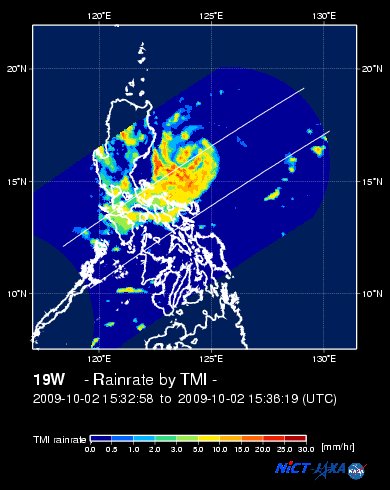
EORC-JAXA TRMM Viewer: Real-Time Rainrate Image new!
NASA-JAXA TMI Viewer: Latest Rainrate Image
Zoomed Satellite Pic: Near Real-Time
Wunderground Animation: 6-12 hr. GIF Loop
PHILIPPINE STORM SIGNAL # THREE (3)
Now In Effect: BATANES-CALAYAN-BABUYAN ISLANDS, CAGAYAN, ILOCOS PROVINCES, ABRA, MT. PROVINCE, APAYAO, KALINGA & NORTHERN ISABELA.
PHILIPPINE STORM WARNING SIGNAL # TWO (2)
Now In Effect: REST OF ISABELA, IFUGAO, NUEVA VIZCAYA, BENGUET & LA UNION.
The above areas will experience stormy weather tonight and tomorrow (with winds not exceeding 100 kph for #02 and more than 100 kph for #03).
PHILIPPINE STORM WARNING SIGNAL # ONE (1)
Now In Effect: QUIRINO, AURORA, NUEVA ECIJA & PANGASINAN.
The above areas will have rains and winds of not more than 60 kph tonight and tomorrow. Coastal waters will be moderate to rough.
Residents living in low-lying and mountainous areas under Public Storm Warning Signal Numbers 3, 2 & 1 are alerted against flashfloods, mudflows, mudslides and landslides.
JTWC (US NAVY/AIR FORCE) 12, 24, 48 & 72 HR. FORECAST & REMARKS:
2 AM (18 GMT) 04 OCTOBER: 18.7N 121.1E / 130-160 KPH (TY-Cat 1) / NNW @ 07 KPH
<<<Typhoon2000.
Get the latest 3-hrly SMS Storm Alerts on PEPENG!
For more details: Text T2K TYPHOON to
2800 (Globe/TM) | 216 (Smart/TNT) | 2288 (Sun)
*only P2.50 (Smart/Globe) / P2.00 (Sun) per msg received.
powered by: Synermaxx
Typhoon2000 (T2K) NEWS (Thu October 01 2009):
Currently issuing 6-hrly advisories (except 12:00 AM) on Typhoon PARMA (PEPENG).
PARMA (PEPENG) MAX WIND SPEED PER AGENCY:
+ Philippines (PAGASA/10-min avg): 175 km/hr
+ Beijing (NMC/2-min avg): 170 kph
+ Taiwan (CWB/10-min avg): 160 km/hr
+ Korea (KMA/10-min avg): 150 km/hr
+ USA (JTWC/1-min avg): 150 km/hr
+ Hong Kong (HKO/10-min avg): 145 km/hr
+ Japan (JMA/10-min avg): 140 km/hr
TYPHOON PARMA [PEPENG/19W/
T2K PUBLIC ADVISORY NUMBER 017
6:00 PM PST (10:00 GMT) Sat 03 October 2009
Source: T2K ANALYSIS / JTWC WARNING #023
View: Advisory Archives (2004-2009)
*Residents and visitors along Extreme Northern Luzon & Taiwan should closely monitor the progress of PARMA.
*Kindly refer to your local warnings & bulletins issued by your country's official weather agency. This advisory is intended for additional information purposes only.
+ Forecast Outlook: PARMA is expected to continue moving WNW for the next 12 hours across Extreme Northern Luzon and shall weaken, turning NW very slowly while along the coast of NW Cagayan, near Ilocos Norte tomorrow afternoon. .The 2 to 5-day Long-Range Forecast shows the system remaining quasi-stationary along the Balintang Channel from Sunday evening until Monday afternoon. PARMA shall begin drift ENE to East slowly across the Batanes Group on Monday afternoon...
+ Effects: PARMA's main circulation remains over Northern Luzon...Its core (eye & eyewall) is now making landfall over Cagayan...Typhoon conditions of winds not exceeding 185 kph can be expected along Cagayan and Apayao...while its inner (rain) bands spreading across the whole of Northern Luzon - where stormy conditions w/ winds not exceeding 100 kph. Central Luzon will be under PARMA's outer (feeder) bands), where moderate to heavy rains w/ winds not exceeding 60 kph can be expected. 1-day rainfall accumulations of 100 up to 200 mm (moderate to heavy rain) can be expected along PARMA's rainbands...
(1) Typhoon MELOR (20W) approaching the northernmost part of Marianas. Click here to view latest T2K advisory.
Kindly click the cool T2K Graphical Satellite Analysis, issued every afternoon, and shows various tropical systems roaming across the South China Sea and the Western Pacific Ocean.
[Important Note: Please keep in mind that the above forecast outlook, effects, current monsoon intensity, & tropical cyclone watch changes every 6 to 12 hrs!]
Time/Date: 6:00 PM PST Sat October 03 2009
Location of Eye: 18.1º N Lat 122.0º E Lon
Distance 1: 45 km (25 nm) SE of Aparri, Cagayan
Distance 2: 65 km (35 nm) NNE of Tuguegarao City
Distance 3: 150 km (80 nm) East of Laoag City
Distance 4: 145 km (78 nm) SSE of Calayan Island
Distance 5: 265 km (143 nm) South of Basco, Batanes
Distance 6: 400 km (215 nm) NNE of Metro Manila
MaxWinds (1-min avg): 150 kph (80 kts) near the eye
Peak Wind Gusts: 185 kph (100 kts)
Saffir-Simpson Typhoon Scale: Category 1
Coastal Storm Surge Height: 4-5 feet [1.2-1.7 m]
Minimum Central Pressure: 963 millibars (hPa)
Recent Movement: WNW @ 17 kph (09 kts)
Projected Area of Impact: Apayao
Size (in Diameter): 610 km (330 nm) / Average
Max Sea Wave Height (near center): 32 ft (9.7 m)
T2K TrackMap #07 (for Public): 6 PM PST Sat Oct 03
JTWC Ship Avoidance TrackMap: 06 GMT Fri Oct 02
Multi-Agency Forecast TrackMap: 2 PM Sat Oct 03
TSR Wind Probabilities: Current to 5-days Ahead
EORC-JAXA TRMM Viewer: Real-Time Rainrate Image new!
NASA-JAXA TMI Viewer: Latest Rainrate Image
Zoomed Satellite Pic: Near Real-Time
Wunderground Animation: 6-12 hr. GIF Loop
PHILIPPINE STORM SIGNAL # THREE (3)
Now In Effect: BATANES-CALAYAN-
PHILIPPINE STORM WARNING SIGNAL # TWO (2)
Now In Effect: REST OF ISABELA, IFUGAO, NUEVA VIZCAYA, BENGUET & LA UNION.
The above areas will experience stormy weather tonight and tomorrow (with winds not exceeding 100 kph for #02 and more than 100 kph for #03).
PHILIPPINE STORM WARNING SIGNAL # ONE (1)
Now In Effect: QUIRINO, AURORA, NUEVA ECIJA & PANGASINAN.
The above areas will have rains and winds of not more than 60 kph tonight and tomorrow. Coastal waters will be moderate to rough.
Residents living in low-lying and mountainous areas under Public Storm Warning Signal Numbers 3, 2 & 1 are alerted against flashfloods, mudflows, mudslides and landslides.
2 AM (18 GMT) 04 OCTOBER: 18.7N 121.1E / 130-160 KPH (TY-Cat 1) / NNW @ 07 KPH
2 PM (06 GMT) 04 OCTOBER: 19.4N 120.8E / 130-160 KPH (TY-Cat 1) / N @ 05 KPH
2 PM (06 GMT) 05 OCTOBER: 20.4N 121.0E / 150-185 KPH (TY-Cat 1) / NE @ 05 KPH
2 PM (06 GMT) 06 OCTOBER: 21.1N 122.0E / 160-195 KPH (TY-Cat 2) / E @ 07 KPH
2 PM (06 GMT) 05 OCTOBER: 20.4N 121.0E / 150-185 KPH (TY-Cat 1) / NE @ 05 KPH
2 PM (06 GMT) 06 OCTOBER: 21.1N 122.0E / 160-195 KPH (TY-Cat 2) / E @ 07 KPH
REMARKS: 2 PM (06 GMT) 03 OCTOBER POSITION: 17.8N 122.1E.
*PARMA HAS MADE LANDFALL WITH THE NORTHEASTERN
PORTION OF LUZON AND IS EXPECTED TO SLOWLY TRACK ALONG THE NORTHERN
COASTLINE FOR THE NEXT 12 HOURS. THE INITIAL FORECAST INTENSITY IS
BASED ON DVORAK SATELLITE INTENSITY FIXES FROM PGTW AND RJTD. PARMA
IS FORECAST TO LINGER TO THE NORTH OF LUZON UNTIL 05/06Z IN A WEAK
STEERING ENVIRONMENT, AND IS EXPECTED TO SLOWLY REINTENSIFY AS IT
PULLS FURTHER NORTH AND AWAY FROM THE INFLUENCES OF LAND. UPWELLING
OF RELATIVELY COOLER SUB-SURFACE OCEAN TEMPERATURES SHOULD RETARD
AGGRESSIVE RE-INTENSIFICATION, AT LEAST THROUGH TAU 48. AFTER TAU 48
THE SYSTEM WILL BEGIN TO TRACK TOWARDS THE SOUTHEAST AS IT INTERACTS
WITH TY 20W. AFTER TY 20W PULLS OUT TO THE NORTHEAST, TY 19W WILL
FOLLOW SUIT (IN A NORTHEASTWARD DIRECTION) AS THE RIDGING TO THE
EAST SLOWLY BUILDS BACK IN TO THE WEST...(more)
>> PARMA, meaning: Macanese food (ham with chicken livers and mushrooms). Name contributed by: Macau, China.
____________
_______________________________________________________________________________________________________________________________________
RECENT T2K TRACKING CHART:

________________________
RECENT MTSAT-1R SATELLITE IMAGE:

> Image source: NOAA SATELLITE CENTER
RECENT WUNDERGROUND SATELLITE ANIMATION: (EXPERIENCING TECHNICAL PROBLEMS)

> Image source: Wunderground.com (http://www.wunderground.com/ ) ____________________________________________________________________________________________________________________
> Image source: NOAA SATELLITE CENTER
____________________________________________________________________________________________________________________
RECENT WUNDERGROUND SATELLITE ANIMATION: (EXPERIENCING TECHNICAL PROBLEMS)
> Image source: Wunderground.
NOTE:
^ - JTWC commentary remarks (for Meteorologists) from their latest warning.
__________________________________________________________________________________________
>> To know the meteorological terminologies and acronyms used on this update visit the ff:
http://typhoon2000.ph/tcterm.htm
http://www.nhc.noaa.gov/aboutgloss.shtml
http://www.srh.noaa.gov/oun/severewx/glossary.php
http://www.srh.weather.gov/fwd/glossarynation.html
http://www.nhc.noaa.gov/acronyms.shtml
__________________________________________________________________________________________
For the complete details on TY PARMA (PEPENG)...go visit our website @:
> http://www.typhoon2000.com
> http://www.maybagyo.com
>> To know the meteorological terminologies and acronyms used on this update visit the ff:
http://typhoon2000.
http://www.nhc.
http://www.srh.
http://www.srh.
http://www.nhc.
____________
> http://www.typhoon2
> http://www.maybagyo
Copyright © 2009 Typhoon2000.
__._,_.___
MARKETPLACE
Change settings via the Web (Yahoo! ID required)
Change settings via email: Switch delivery to Daily Digest | Switch format to Traditional
Visit Your Group | Yahoo! Groups Terms of Use | Unsubscribe
.
__,_._,___

No comments:
Post a Comment