
for Tuesday, 20 October 2009 [11:52 AM PST]


<<<Typhoon2000.com Mobile >>>
Get the latest 6-hrly SMS Storm Alerts on RAMIL!
For more details: Text T2K TYPHOON to
2800 (Globe/TM) | 216 (Smart/TNT) | 2288 (Sun)
*only P2.50 (Smart/Globe) / P2.00 (Sun) per msg received.
powered by: Synermaxx
Typhoon2000 (T2K) NEWS (Tue October 20 2009):
Currently issuing 6-hrly advisories (except 12:00 AM) on TY LUPIT (RAMIL)
LUPIT (RAMIL) MAX WIND SPEED PER AGENCY:
+ Philippines (PAGASA/10-min avg): 195 km/hr
+ USA (JTWC/1-min avg): 175 km/hr
+ Beijing (NMC/2-min avg): 165 kph
+ Taiwan (CWB/10-min avg): 165 km/hr
+ Korea (KMA/10-min avg): 165 km/hr
+ Japan (JMA/10-min avg): 150 km/hr
TYPHOON LUPIT [RAMIL/22W/0920]
T2K PUBLIC ADVISORY NUMBER 019
12:00 PM PST (04:00 GMT) Tue 20 October 2009
Source: T2K ANALYSIS / JTWC WARNING #025
View: Advisory Archives (2004-2009)
Typhoon LUPIT (RAMIL) continues to weaken while cruising the Northern Philippine Sea...remains in an area of drier and stable air...downgraded to Category 2...may start to turn West to WSW tonight or tomorrow...more Philippine Storm Warning Signals (PSWS) raised (see below for more details).
*Residents and visitors along the Island of Luzon (particularly Northern Luzon) should closely monitor the progress of LUPIT (RAMIL).
*Kindly refer to your local warnings & bulletins issued by your country's official weather agency. This advisory is intended for additional information purposes only.
+ Forecast Outlook: LUPIT is expected to slightly decelerate and turn more westerly to WSW-ward w/in the next 12 to 24 hours. Its wind speed will slighty strengthen back to Category 3 (185 kph) as it moves closer to Northern Luzon due to improve atmospheric conditions (warm ocean moisture & unstable air). The 2 to 5-day Long-Range Forecast shows LUPIT approaching the coast of Cagayan on a WSW direction, as the High Pressure Steering Ridge building off China strengthens and steer the dangerous typhoon. LUPIT shall make landfall over Eastern Cagayan on Thursday evening Oct 22...passing to the south of Aparri or north of Tuguegarao City around early Friday morning Oct 23. It shall cross Kalinga and exit thru Ilocos Sur Friday afternoon and evening Oct 23 and over the South China Sea on Saturday morning, Oct 24. The typhoon shall move westward while over the South China Sea, in the direction of Hainan Island-Vietnam Area on Sunday Oct 25. *Alternate Forecast Scenario: There is a possibility that LUPIT might track more WSW-ward earlier than expected with a strike across the southern part of Northern Luzon thru Isabela Province, Benguet & La Union. This scenario is likely if the high pressure steering ridge located off Eastern China strengthens more and dig deeper southward. The probability of this alternate forecast still remains low. Please be reminded that the Forecast Outlook changes every 6 hours, so a shift to the left or right of its future track and other conditions must be considered.
+ Effects: LUPIT's large circulation continues to deteriorate while moving into an area of drier & stable air. The eye remains cloud-filled as shown on current satellite images. Its outer & inner rain bands remains at sea...not yet affecting any major islands at this time. LUPIT may begin to affect Northern Luzon beginning tomorrow (Oct 21) - if the forecast movement continues...deteriorating weather conditions expected. 1-day rainfall accumulations of 75 up to 200 mm (moderate to heavy rain) can be expected along its rainbands...with isolated accumulations of 400 mm or more (very heavy to extreme rain) near the center of LUPIT particularly along its projected path.
[Important Note: Please keep in mind that the above forecast outlook, effects, current monsoon intensity, & tropical cyclone watch changes every 6 to 12 hrs!]
Time/Date: 12:00 PM PST Tue October 20 2009
Location of Eye: 20.4º N Lat 130.0º E Lon
Distance 1: 835 km (452 nm) East of Basco, Batanes
Distance 2: 900 km (487 nm) ENE of Aparri, Cagayan
Distance 3: 925 km (500 nm) ENE of Tuguegarao City
Distance 4: 935 km (515 nm) NE of Ilagan City
Distance 5: 955 km (515 nm) NE of Casiguran, Aurora
Distance 6: 1,045 km (565 nm) NE of Naga City
Distance 7: 1,140 km (615 nm) NE of Metro Manila
MaxWinds (1-min avg): 175 kph (95 kts) near the Eye
Peak Wind Gusts: 215 kph (115 kts)
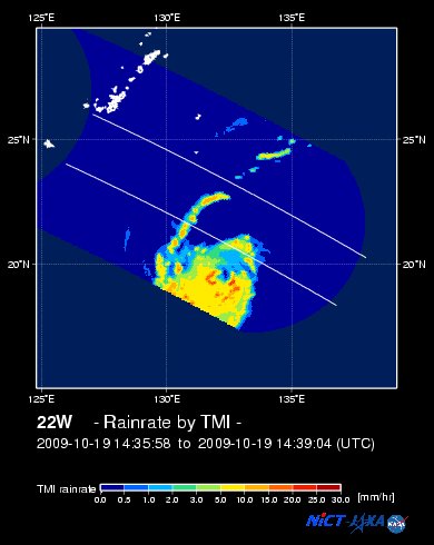
Rainbands' Rain Rate: 2 to 30 mm/hr (.02 to 1.2 in/hr) new!
Saffir-Simpson Typhoon Scale: Category 2
Coastal Storm Surge Height: 6-8 feet [1.8-2.6 m]
Minimum Central Pressure: 952 millibars (hPa)
Recent Movement: WNW @ 19 kph (10 kts)
Projected Area of Impact: Extreme Northern Luzon
Size (in Diameter): 890 km (480 nm) / Very Large
Max Sea Wave Height (near center): 33 ft (10.0 m)
JTWC Ship Avoidance TrackMap: 8 AM Tue Oct 20
Multi-Agency Forecast TrackMap: 8 AM Tue Oct 20
TSR Wind Probabilities: Current to 5-days Ahead
NASA-JAXA TMI Image: Latest Rainrate 01
EORC-JAXA TRMM Image: Latest Rainrate 02
Zoomed Satellite Pic: Near Real-Time
Wunderground Animation: 6-12 hr. GIF Loop
PHILIPPINE STORM WARNING SIGNAL # TWO (2)
Now In Effect: BATANES ISLAND GROUP, CAGAYAN, CALAYAN & BABUYAN ISLANDS, & ISABELA.
The above areas will experience stormy weather beginning tomorrow afternoon (with winds not exceeding 100 kph). Coastal waters will be rough to very rough and extremely dangerous to all types of seacrafts.
PHILIPPINE STORM WARNING SIGNAL # ONE (1)
Now In Effect: ILOCOS NORTE, APAYAO, ABRA, KALINGA, MOUNTAIN PROVINCE, IFUGAO, NUEVA VIZCAYA, QUIRINO, AURORA, & POLILLO ISLAND.
The above areas will have rains and winds of not more than 60 kph beginning tonight or tomorrow. Coastal waters will be moderate to rough.
Residents living in low-lying and mountainous areas under Public Storm Warning Signal Number 1 are alerted against flashfloods, mudflows, mudslides and landslides.
JTWC (US NAVY / AIR FORCE) 12, 24, 48 & 72 HR. FORECAST & REMARKS:
8 PM (12 GMT) 20 OCTOBER: 20.2N 128.6E / 185-230 KPH (TY-Cat 3) / W @ 17 KPH
<<<Typhoon2000.
Get the latest 6-hrly SMS Storm Alerts on RAMIL!
For more details: Text T2K TYPHOON to
2800 (Globe/TM) | 216 (Smart/TNT) | 2288 (Sun)
*only P2.50 (Smart/Globe) / P2.00 (Sun) per msg received.
powered by: Synermaxx
Typhoon2000 (T2K) NEWS (Tue October 20 2009):
Currently issuing 6-hrly advisories (except 12:00 AM) on TY LUPIT (RAMIL)
LUPIT (RAMIL) MAX WIND SPEED PER AGENCY:
+ Philippines (PAGASA/10-min avg): 195 km/hr
+ USA (JTWC/1-min avg): 175 km/hr
+ Beijing (NMC/2-min avg): 165 kph
+ Taiwan (CWB/10-min avg): 165 km/hr
+ Korea (KMA/10-min avg): 165 km/hr
+ Japan (JMA/10-min avg): 150 km/hr
TYPHOON LUPIT [RAMIL/22W/0920]
T2K PUBLIC ADVISORY NUMBER 019
12:00 PM PST (04:00 GMT) Tue 20 October 2009
Source: T2K ANALYSIS / JTWC WARNING #025
View: Advisory Archives (2004-2009)
*Residents and visitors along the Island of Luzon (particularly Northern Luzon) should closely monitor the progress of LUPIT (RAMIL).
*Kindly refer to your local warnings & bulletins issued by your country's official weather agency. This advisory is intended for additional information purposes only.
+ Forecast Outlook: LUPIT is expected to slightly decelerate and turn more westerly to WSW-ward w/in the next 12 to 24 hours. Its wind speed will slighty strengthen back to Category 3 (185 kph) as it moves closer to Northern Luzon due to improve atmospheric conditions (warm ocean moisture & unstable air). The 2 to 5-day Long-Range Forecast shows LUPIT approaching the coast of Cagayan on a WSW direction, as the High Pressure Steering Ridge building off China strengthens and steer the dangerous typhoon. LUPIT shall make landfall over Eastern Cagayan on Thursday evening Oct 22...passing to the south of Aparri or north of Tuguegarao City around early Friday morning Oct 23. It shall cross Kalinga and exit thru Ilocos Sur Friday afternoon and evening Oct 23 and over the South China Sea on Saturday morning, Oct 24. The typhoon shall move westward while over the South China Sea, in the direction of Hainan Island-Vietnam Area on Sunday Oct 25. *Alternate Forecast Scenario: There is a possibility that LUPIT might track more WSW-ward earlier than expected with a strike across the southern part of Northern Luzon thru Isabela Province, Benguet & La Union. This scenario is likely if the high pressure steering ridge located off Eastern China strengthens more and dig deeper southward. The probability of this alternate forecast still remains low. Please be reminded that the Forecast Outlook changes every 6 hours, so a shift to the left or right of its future track and other conditions must be considered.
+ Effects: LUPIT's large circulation continues to deteriorate while moving into an area of drier & stable air. The eye remains cloud-filled as shown on current satellite images. Its outer & inner rain bands remains at sea...not yet affecting any major islands at this time. LUPIT may begin to affect Northern Luzon beginning tomorrow (Oct 21) - if the forecast movement continues...
Time/Date: 12:00 PM PST Tue October 20 2009
Location of Eye: 20.4º N Lat 130.0º E Lon
Distance 1: 835 km (452 nm) East of Basco, Batanes
Distance 2: 900 km (487 nm) ENE of Aparri, Cagayan
Distance 3: 925 km (500 nm) ENE of Tuguegarao City
Distance 4: 935 km (515 nm) NE of Ilagan City
Distance 5: 955 km (515 nm) NE of Casiguran, Aurora
Distance 6: 1,045 km (565 nm) NE of Naga City
Distance 7: 1,140 km (615 nm) NE of Metro Manila
MaxWinds (1-min avg): 175 kph (95 kts) near the Eye
Peak Wind Gusts: 215 kph (115 kts)
Rainbands' Rain Rate: 2 to 30 mm/hr (.02 to 1.2 in/hr) new!
Saffir-Simpson Typhoon Scale: Category 2
Coastal Storm Surge Height: 6-8 feet [1.8-2.6 m]
Minimum Central Pressure: 952 millibars (hPa)
Recent Movement: WNW @ 19 kph (10 kts)
Projected Area of Impact: Extreme Northern Luzon
Size (in Diameter): 890 km (480 nm) / Very Large
Max Sea Wave Height (near center): 33 ft (10.0 m)
JTWC Ship Avoidance TrackMap: 8 AM Tue Oct 20
Multi-Agency Forecast TrackMap: 8 AM Tue Oct 20
TSR Wind Probabilities: Current to 5-days Ahead
NASA-JAXA TMI Image: Latest Rainrate 01
EORC-JAXA TRMM Image: Latest Rainrate 02
Zoomed Satellite Pic: Near Real-Time
Wunderground Animation: 6-12 hr. GIF Loop
PHILIPPINE STORM WARNING SIGNAL # TWO (2)
Now In Effect: BATANES ISLAND GROUP, CAGAYAN, CALAYAN & BABUYAN ISLANDS, & ISABELA.
The above areas will experience stormy weather beginning tomorrow afternoon (with winds not exceeding 100 kph). Coastal waters will be rough to very rough and extremely dangerous to all types of seacrafts.
PHILIPPINE STORM WARNING SIGNAL # ONE (1)
Now In Effect: ILOCOS NORTE, APAYAO, ABRA, KALINGA, MOUNTAIN PROVINCE, IFUGAO, NUEVA VIZCAYA, QUIRINO, AURORA, & POLILLO ISLAND.
The above areas will have rains and winds of not more than 60 kph beginning tonight or tomorrow. Coastal waters will be moderate to rough.
Residents living in low-lying and mountainous areas under Public Storm Warning Signal Number 1 are alerted against flashfloods, mudflows, mudslides and landslides.
8 PM (12 GMT) 20 OCTOBER: 20.2N 128.6E / 185-230 KPH (TY-Cat 3) / W @ 17 KPH
8 AM (00 GMT) 21 OCTOBER: 19.9N 126.7E / 185-230 KPH (TY-Cat 3) / WSW @ 15 KPH
8 AM (00 GMT) 22 OCTOBER: 18.7N 123.5E / 175-215 KPH (TY-Cat 2) / WSW @ 11 KPH
8 AM (00 GMT) 23 OCTOBER: 17.9N 121.3E / 140-165 KPH (TY-Cat 1) / WSW @ 11 KPH
8 AM (00 GMT) 22 OCTOBER: 18.7N 123.5E / 175-215 KPH (TY-Cat 2) / WSW @ 11 KPH
8 AM (00 GMT) 23 OCTOBER: 17.9N 121.3E / 140-165 KPH (TY-Cat 1) / WSW @ 11 KPH
REMARKS: 8 AM (00 GMT) TUE 20 OCTOBER POSITION: 20.1N 130.5E.
*TY 22W IS EXPECTED TO CONTINUE TRACKING GENERALLY WESTWARD
OVER THE NEXT 24 TO 36 HOURS IN THE CURRENT STEERING FLOW PATTERN.
THEREAFTER, THE FLOW ASSOCIATED WITH A SUBTROPICAL RIDGE TO THE
NORTHWEST IS EXPECTED TO PUSH THE TYPHOON ON A MORE EQUATORWARD
TRACK. THIS FLOW WILL BRING TY 22W INTO NORTHERN LUZON BY TAU 72.
DESPITE RECENT STRUCTURAL CHANGES MENTIONED IN PARAGRAPH 2, GOOD
UPPER LEVEL OUTFLOW AND LOW VERTICAL WIND SHEAR WILL PREVENT THE
CURRENT WEAKENING TREND FROM CONTINUING AND SHOULD ALLOW THE CYCLONE
TO REINTENSIFY A BIT, PRIOR TO LANDFALL, AS THE EYEWALL REBUILDS.
THE AVAILABLE NUMERICAL MODEL GUIDANCE, WITH THE NOTABLE EXCEPTIONS
OF WBAR AND TCLAPS, IS IN GOOD OVERALL AGREEMENT WITH THE CURRENT
TRACK FORECAST. THE WBAR AND TCLAPS SOLUTIONS DEPICT IMMEDIATE
NORTHEASTWARD RECURVATURE INTO THE MIDLATITUDE WESTERLIES. HOWEVER,
THE LACK OF A CLEAR BREAK IN THE STEERING RIDGE TO THE NORTH AND
HIGHLY ZONAL UPSTREAM MIDLATITUDE FLOW INDICATE THAT A RECURVATURE
SCENARIO IS VERY IMPROBABLE. THEREFORE, THE CURRENT FORECAST FOLLOWS
THE MAIN MODEL GROUPING...(more)
>> LUPIT, meaning: Cruel; viciousness. Name contributed by: Philippines.
____________
PAGASA CURRENT POSITION, MOVEMENT AND INTENSITY (10-min. ave.):
> 10 AM (02 GMT) 20 OCTOBER: 20.2N 130.3E / WEST @ 17 kph / 195 kph
:: For the complete PAGASA bulletin, kindly visit their website at:
http://www.pagasa.dost.gov.ph/wb/tcupdate.shtml
_______________________________________________________________________________________________________________________________________
:: For the complete PAGASA bulletin, kindly visit their website at:
http://www.pagasa.
____________
RECENT TYPHOON2000.

________________________
RECENT MTSAT-1R SATELLITE IMAGE:

> Image source: NOAA SATELLITE CENTER
RECENT WUNDERGROUND SATELLITE ANIMATION:

> Image source: Wunderground.com (http://www.wunderground.com/ ) ____________________________________________________________________________________________________________________
> Image source: NOAA SATELLITE CENTER
____________________________________________________________________________________________________________________
RECENT WUNDERGROUND SATELLITE ANIMATION:
> Image source: Wunderground.
NOTE:
^ - JTWC commentary remarks (for Meteorologists) from their latest warning.
__________________________________________________________________________________________
>> To know the meteorological terminologies and acronyms used on this update visit the ff:
http://typhoon2000.ph/tcterm.htm
http://www.nhc.noaa.gov/aboutgloss.shtml
http://www.srh.noaa.gov/oun/severewx/glossary.php
http://www.srh.weather.gov/fwd/glossarynation.html
http://www.nhc.noaa.gov/acronyms.shtml
__________________________________________________________________________________________
For the complete details on TY LUPIT (RAMIL)...go visit our website @:
> http://www.typhoon2000.com
> http://www.maybagyo.com
>> To know the meteorological terminologies and acronyms used on this update visit the ff:
http://typhoon2000.
http://www.nhc.
http://www.srh.
http://www.srh.
http://www.nhc.
____________
> http://www.typhoon2
> http://www.maybagyo
Copyright © 2009 Typhoon2000.
__._,_.___
MARKETPLACE
Change settings via the Web (Yahoo! ID required)
Change settings via email: Switch delivery to Daily Digest | Switch format to Traditional
Visit Your Group | Yahoo! Groups Terms of Use | Unsubscribe
.
__,_._,___

No comments:
Post a Comment