
for Monday, 05 October 2009 [5:58 AM PST]


<<<Typhoon2000.com Mobile >>>
Get the latest 6-hrly SMS Storm Alerts on PEPENG!
For more details: Text T2K TYPHOON to
2800 (Globe/TM) | 216 (Smart/TNT) | 2288 (Sun)
*only P2.50 (Smart/Globe) / P2.00 (Sun) per msg received.
powered by: Synermaxx
Typhoon2000 (T2K) NEWS (Mon October 05 2009):
SMS updates returns back to 6-hrly updates...currently issuing 6-hrly advisories (except 12:00 AM) on TS PARMA (PEPENG).
PARMA (PEPENG) MAX WIND SPEED PER AGENCY:
+ Hong Kong (HKO/10-min avg): 120 km/hr
+ Philippines (PAGASA/10-min avg): 120 km/hr
+ Taiwan (CWB/10-min avg): 105 km/hr
+ Korea (KMA/10-min avg): 100 km/hr
+ USA (JTWC/1-min avg): 100 km/hr
+ Japan (JMA/10-min avg): 100 km/hr
+ Beijing (NMC/2-min avg): 95 kph
TROPICAL STORM PARMA [PEPENG/19W/0917]
T2K PUBLIC ADVISORY NUMBER 021
6:00 AM PST (22:00 GMT) Mon 05 October 2009
Source: T2K ANALYSIS / JTWC WARNING #029
View: Advisory Archives (2004-2009)
PARMA (PEPENG) loses strength...downgraded to a strong Tropical Storm...drifting slowly WNW over the South China Sea.
*Residents and visitors along Extreme Northern Luzon, Southern China & Taiwan should closely monitor the progress of PARMA.
*Kindly refer to your local warnings & bulletins issued by your country's official weather agency. This advisory is intended for additional information purposes only. |
+ Forecast Outlook: PARMA is expected to move very slowly or quasi-stationary over the South China Sea, west of Balintang Channel for the next 1 to 3 days. The 3 to 5-day Long-Range Forecast shows PARMA drifting South, SSW to SW-ward across the South China Sea. *Alternate Forecast Scenario: There's also a possibility that PARMA and MELOR shall be both into Direct Cyclone Interaction (DCI) (aka. Fujiwhara Effect)...where MELOR recurves to the NE and PARMA follows suit. This scenaro remains least possible forecast route at this time.
+ Effects: PARMA's main circulation has become weak...Its core (eye & eyewall) is now about 260km. from the coast of Ilocos Norte...Stormy conditions w/ winds not exceeding 100 kph can still be expected along Ilocos Norte...while its inner (rain) bands spreading across Ilocos Sur, Abra, Kalinga, Apayao, Calayan Island Group, and Western Cagayan - where stormy conditions w/ winds not exceeding 75 kph can be expected today. Central Luzon and rest of Northern Luzon will remain under PARMA's outer (feeder) bands), where light to moderate rains w/ winds not exceeding 60 kph can be expected today. 1-day rainfall accumulations of 50 up to 150 mm (moderate to heavy rain) can be expected along PARMA's rainbands...with isolated accumulations of up to 300 mm (very heavy rain) near the center of PARMA. Residents in low-lying areas & steep slopes must remain alert & seek evacuation for possible life-threatening flash floods, mudslides & landslides due to the anticipated heavy rains brought about by this system. Precautionary measures must be initiated if necessary. Possible coastal Storm Surge flooding of 4 to 5 feet above normal tide levels...accompanied by large and dangerous battering waves...is possible along the coastal areas of Extreme Northwestern Luzon. Minimal damage is likely on this type of storm surge.
+ Tropical Cyclone Watch:
(1) Super Typhoon MELOR (20W) approaching PAR, expected to enter this afternoon. Click here to view latest T2K advisory.
Kindly click the cool T2K Graphical Satellite Analysis, issued every afternoon, and shows various tropical systems roaming across the South China Sea and the Western Pacific Ocean.
[Important Note: Please keep in mind that the above forecast outlook, effects, current monsoon intensity, & tropical cyclone watch changes every 6 to 12 hrs!]
Time/Date: 6:00 AM PST Sun October 04 2009
Location of Eye: 20.2º N Lat 119.3º E Lon
Distance 1: 250 km (135 nm) WNW of Calayan Island
Distance 2: 260 km (140 nm) NNW of Laoag City
Distance 3: 270 km (145 nm) WSW of Basco, Batanes
Distance 4: 285 km (155 nm) SSW of Kaohsiung, Taiwan
Distance 5: 580 km (313 nm) ESE of Hong Kong
MaxWinds (1-min avg): 100 kph (55 kts) near the eye
Peak Wind Gusts: 130 kph (70 kts)
Saffir-Simpson Typhoon Scale: Tropical Storm
Coastal Storm Surge Height: 1-3 feet [0.3-0.9 m]
Minimum Central Pressure: 982 millibars (hPa)
Recent Movement: WNW @ 07 kph (04 kts)
Projected Area of Impact: South China Sea
Size (in Diameter): 815 km (440 nm) / Large
Max Sea Wave Height (near center): 29 ft (8.8 m)
T2K TrackMap #10 (for Public): 6 AM PST Mon Oct 05
JTWC Ship Avoidance TrackMap: 2 AM Mon Oct 5
Multi-Agency Forecast TrackMap: 2 AM Mon Oct 4
TSR Wind Probabilities: Current to 5-days Ahead
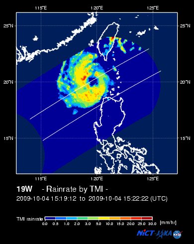
EORC-JAXA TRMM Viewer: Real-Time Rainrate Image
NASA-JAXA TMI Viewer: Latest Rainrate Image
Zoomed Satellite Pic: Near Real-Time
Wunderground Animation: 6-12 hr. GIF Loop
PHILIPPINE STORM SIGNAL # THREE (3)
In Effect: ILOCOS NORTE.
PHILIPPINE STORM WARNING SIGNAL # TWO (2)
In Effect: BATANES-CALAYAN-BABUYAN ISLANDS, NORTHERN CAGAYAN, ILOCOS SUR, ABRA, KALINGA & APAYAO.
The above areas will experience stormy weather today (with winds not exceeding 100 kph for #02 and more than 100 kph for #03).
PHILIPPINE STORM WARNING SIGNAL # ONE (1)
In Effect: REST OF CAGAYAN, LA UNION, BENGUET & MT. PROVINCE.
The above areas will have rains and winds of not more than 60 kph today. Coastal waters will be moderate to rough.
Residents living in low-lying and mountainous areas under Public Storm Warning Signal Numbers 3, 2 & 1 are alerted against flashfloods, mudflows, mudslides and landslides.
JTWC (US NAVY/AIR FORCE) 12, 24, 48 & 72 HR. FORECAST & REMARKS:
2 PM (06 GMT) 05 OCTOBER: 20.2N 119.0E / 110-140 KPH (TS) / SSW @ 02 KPH
<<<Typhoon2000.
Get the latest 6-hrly SMS Storm Alerts on PEPENG!
For more details: Text T2K TYPHOON to
2800 (Globe/TM) | 216 (Smart/TNT) | 2288 (Sun)
*only P2.50 (Smart/Globe) / P2.00 (Sun) per msg received.
powered by: Synermaxx
Typhoon2000 (T2K) NEWS (Mon October 05 2009):
SMS updates returns back to 6-hrly updates...currently issuing 6-hrly advisories (except 12:00 AM) on TS PARMA (PEPENG).
PARMA (PEPENG) MAX WIND SPEED PER AGENCY:
+ Hong Kong (HKO/10-min avg): 120 km/hr
+ Philippines (PAGASA/10-min avg): 120 km/hr
+ Taiwan (CWB/10-min avg): 105 km/hr
+ Korea (KMA/10-min avg): 100 km/hr
+ USA (JTWC/1-min avg): 100 km/hr
+ Japan (JMA/10-min avg): 100 km/hr
+ Beijing (NMC/2-min avg): 95 kph
TROPICAL STORM PARMA [PEPENG/19W/
T2K PUBLIC ADVISORY NUMBER 021
6:00 AM PST (22:00 GMT) Mon 05 October 2009
Source: T2K ANALYSIS / JTWC WARNING #029
View: Advisory Archives (2004-2009)
*Residents and visitors along Extreme Northern Luzon, Southern China & Taiwan should closely monitor the progress of PARMA.
*Kindly refer to your local warnings & bulletins issued by your country's official weather agency. This advisory is intended for additional information purposes only.
+ Forecast Outlook: PARMA is expected to move very slowly or quasi-stationary over the South China Sea, west of Balintang Channel for the next 1 to 3 days. The 3 to 5-day Long-Range Forecast shows PARMA drifting South, SSW to SW-ward across the South China Sea. *Alternate Forecast Scenario: There's also a possibility that PARMA and MELOR shall be both into Direct Cyclone Interaction (DCI) (aka. Fujiwhara Effect)...where MELOR recurves to the NE and PARMA follows suit. This scenaro remains least possible forecast route at this time.
+ Effects: PARMA's main circulation has become weak...Its core (eye & eyewall) is now about 260km. from the coast of Ilocos Norte...Stormy conditions w/ winds not exceeding 100 kph can still be expected along Ilocos Norte...while its inner (rain) bands spreading across Ilocos Sur, Abra, Kalinga, Apayao, Calayan Island Group, and Western Cagayan - where stormy conditions w/ winds not exceeding 75 kph can be expected today. Central Luzon and rest of Northern Luzon will remain under PARMA's outer (feeder) bands), where light to moderate rains w/ winds not exceeding 60 kph can be expected today. 1-day rainfall accumulations of 50 up to 150 mm (moderate to heavy rain) can be expected along PARMA's rainbands...
(1) Super Typhoon MELOR (20W) approaching PAR, expected to enter this afternoon. Click here to view latest T2K advisory.
Kindly click the cool T2K Graphical Satellite Analysis, issued every afternoon, and shows various tropical systems roaming across the South China Sea and the Western Pacific Ocean.
[Important Note: Please keep in mind that the above forecast outlook, effects, current monsoon intensity, & tropical cyclone watch changes every 6 to 12 hrs!]
Time/Date: 6:00 AM PST Sun October 04 2009
Location of Eye: 20.2º N Lat 119.3º E Lon
Distance 1: 250 km (135 nm) WNW of Calayan Island
Distance 2: 260 km (140 nm) NNW of Laoag City
Distance 3: 270 km (145 nm) WSW of Basco, Batanes
Distance 4: 285 km (155 nm) SSW of Kaohsiung, Taiwan
Distance 5: 580 km (313 nm) ESE of Hong Kong
MaxWinds (1-min avg): 100 kph (55 kts) near the eye
Peak Wind Gusts: 130 kph (70 kts)
Saffir-Simpson Typhoon Scale: Tropical Storm
Coastal Storm Surge Height: 1-3 feet [0.3-0.9 m]
Minimum Central Pressure: 982 millibars (hPa)
Recent Movement: WNW @ 07 kph (04 kts)
Projected Area of Impact: South China Sea
Size (in Diameter): 815 km (440 nm) / Large
Max Sea Wave Height (near center): 29 ft (8.8 m)
T2K TrackMap #10 (for Public): 6 AM PST Mon Oct 05
JTWC Ship Avoidance TrackMap: 2 AM Mon Oct 5
Multi-Agency Forecast TrackMap: 2 AM Mon Oct 4
TSR Wind Probabilities: Current to 5-days Ahead
EORC-JAXA TRMM Viewer: Real-Time Rainrate Image
NASA-JAXA TMI Viewer: Latest Rainrate Image
Zoomed Satellite Pic: Near Real-Time
Wunderground Animation: 6-12 hr. GIF Loop
PHILIPPINE STORM SIGNAL # THREE (3)
In Effect: ILOCOS NORTE.
PHILIPPINE STORM WARNING SIGNAL # TWO (2)
In Effect: BATANES-CALAYAN-
The above areas will experience stormy weather today (with winds not exceeding 100 kph for #02 and more than 100 kph for #03).
PHILIPPINE STORM WARNING SIGNAL # ONE (1)
In Effect: REST OF CAGAYAN, LA UNION, BENGUET & MT. PROVINCE.
The above areas will have rains and winds of not more than 60 kph today. Coastal waters will be moderate to rough.
Residents living in low-lying and mountainous areas under Public Storm Warning Signal Numbers 3, 2 & 1 are alerted against flashfloods, mudflows, mudslides and landslides.
2 PM (06 GMT) 05 OCTOBER: 20.2N 119.0E / 110-140 KPH (TS) / SSW @ 02 KPH
2 AM (18 GMT) 06 OCTOBER: 20.0N 118.8E / 110-145 KPH (TS) / SSW @ 02 KPH
2 AM (18 GMT) 07 OCTOBER: 19.6N 118.6E / 120-150 KPH (TY-Cat 1) / SSW @ 04 KPH
2 AM (18 GMT) 08 OCTOBER: 18.8N 118.3E / 130-160 KPH (TY-Cat 1) / SSW @ 04 KPH
2 AM (18 GMT) 07 OCTOBER: 19.6N 118.6E / 120-150 KPH (TY-Cat 1) / SSW @ 04 KPH
2 AM (18 GMT) 08 OCTOBER: 18.8N 118.3E / 130-160 KPH (TY-Cat 1) / SSW @ 04 KPH
REMARKS: 2 AM (18 GMT) 05 OCTOBER POSITION: 20.1N 119.4E.
*RECENT ANIMATED INFRARED IMAGERY SHOWS A DRAMATIC DROP IN CONVECTION
IN AND AROUND THE LOW LEVEL CIRCULATION CENTER (LLCC) ALONG WITH A
DEFORMATION OF THE SYSTEM SHAPE ALONG THE NORTHWEST QUADRANT. THESE
FEATURES ARE ATTRIBUTED TO A MID- TO UPPER-LEVEL MIDLATITUDE TROUGH
THAT IS PASSING TO THE NORTHWEST OF THE SYSTEM. A 041520Z TRMM IMAGE
AT 37GHZ SHOWS THAT THE SYSTEM STILL HAS GOOD STRUCTURE IN THE LOWER
LEVELS WITH WELL FORMED MULTIPLE BANDS WRAPPING INTO THE LLCC AND AN
EYE-LIKE FEATURE. UPPER LEVEL ANALYSIS INDICATES THE SYSTEM HAS GOOD
OUTFLOW TO THE SOUTH AND WEST AND IS IN A REGION OF LOW TO MODERATE
VERTICAL WIND SHEAR (VWS). VWS IS EXPECTED TO INCREASE DURING THE
PASSAGE OF THE PREVIOUSLY MENTIONED MIDLATITUDE TROUGH THROUGH TAU
36. THE SYSTEM IS STILL IN A VERY WEAK STEERING ENVIRONMENT OUTSIDE
OF THE INFLUENCES OF THE SUBTROPICAL RIDGE (STR) CENTERS LOCATED TO
THE NORTHWEST AND NORTHEAST AND IS EXPECTED TO REMAIN QUASI-
STATIONARY IN THE STRAIT OF LUZON THROUGH TAU 48. AT TAU 72 THE STR
TO THE NORTHWEST OVER SOUTHERN CHINA IS EXPECTED TO BUILD AND SLOWLY
STEER THE SYSTEM INTO THE SOUTH CHINA SEA. STRONG COLD WATER
UPWELLING AND THE PASSAGE OF THE MIDLATITUDE TROUGH ARE EXPECTED TO
SUPPRESS ANY SIGNIFICANT INTENSIFICATION BEYOND WEAK TYPHOON. THERE
IS AN EXPECTATION THAT THE SYSTEM MIGHT NOT HAVE ENOUGH ENERGY
AVAILABLE TO RE-INTENSIFY AND WILL START TO WEAKEN SOONER. OBJECTIVE
AID GUIDANCE REMAINS POOR AS NUMERICAL MODELS CONTINUE TO STRUGGLE
WITH THE WEAK STEERING ENVIRONMENT, BUT GFDN, NOGAPS, AND JGSM ALL
CALL FOR A GENERALLY WESTWARD TRACK AFTER TAU 72. ECMWF, UKMO AND
GFS MAINTAIN A QUASI-STATIONARY TRACK THROUGH TAU 120, AFTER THE
RIDGE TO THE WEST BUILDS...(more)
>> PARMA, meaning: Macanese food (ham with chicken livers and mushrooms). Name contributed by: Macau, China.
____________
_______________________________________________________________________________________________________________________________________
RECENT T2K TRACKING CHART:

________________________
RECENT MTSAT-1R SATELLITE IMAGE:

> Image source: NOAA SATELLITE CENTER
RECENT WUNDERGROUND SATELLITE ANIMATION: (EXPERIENCING TECHNICAL PROBLEMS)

> Image source: Wunderground.com (http://www.wunderground.com/ ) ____________________________________________________________________________________________________________________
> Image source: NOAA SATELLITE CENTER
____________________________________________________________________________________________________________________
RECENT WUNDERGROUND SATELLITE ANIMATION: (EXPERIENCING TECHNICAL PROBLEMS)
> Image source: Wunderground.
NOTE:
^ - JTWC commentary remarks (for Meteorologists) from their latest warning.
__________________________________________________________________________________________
>> To know the meteorological terminologies and acronyms used on this update visit the ff:
http://typhoon2000.ph/tcterm.htm
http://www.nhc.noaa.gov/aboutgloss.shtml
http://www.srh.noaa.gov/oun/severewx/glossary.php
http://www.srh.weather.gov/fwd/glossarynation.html
http://www.nhc.noaa.gov/acronyms.shtml
__________________________________________________________________________________________
For the complete details on TS PARMA (PEPENG)...go visit our website @:
> http://www.typhoon2000.com
> http://www.maybagyo.com
>> To know the meteorological terminologies and acronyms used on this update visit the ff:
http://typhoon2000.
http://www.nhc.
http://www.srh.
http://www.srh.
http://www.nhc.
____________
> http://www.typhoon2
> http://www.maybagyo
Copyright © 2009 Typhoon2000.
__._,_.___
Change settings via the Web (Yahoo! ID required)
Change settings via email: Switch delivery to Daily Digest | Switch format to Traditional
Visit Your Group | Yahoo! Groups Terms of Use | Unsubscribe
.
__,_._,___

No comments:
Post a Comment