
for Tuesday, 20 October 2009 [6:00 AM PST]


<<<Typhoon2000.com Mobile >>>
Get the latest 6-hrly SMS Storm Alerts on RAMIL!
For more details: Text T2K TYPHOON to
2800 (Globe/TM) | 216 (Smart/TNT) | 2288 (Sun)
*only P2.50 (Smart/Globe) / P2.00 (Sun) per msg received.
powered by: Synermaxx
Typhoon2000 (T2K) NEWS (Tue October 20 2009):
Currently issuing 6-hrly advisories (except 12:00 AM) on TY LUPIT (RAMIL)
LUPIT (RAMIL) MAX WIND SPEED PER AGENCY:
+ USA (JTWC/1-min avg): 195 km/hr
+ Philippines (PAGASA/10-min avg): 195 km/hr
+ Beijing (NMC/2-min avg): 185 kph
+ Taiwan (CWB/10-min avg): 170 km/hr
+ Korea (KMA/10-min avg): 160 km/hr
+ Japan (JMA/10-min avg): 160 km/hr
TYPHOON LUPIT [RAMIL/22W/0920]
T2K PUBLIC ADVISORY NUMBER 018
6:00 AM PST (22:00 GMT) Tue 20 October 2009
Source: T2K ANALYSIS / JTWC WARNING #024
View: Advisory Archives (2004-2009)
Typhoon LUPIT (RAMIL) weakens over the Northern Philippine Sea as it enters an area of drier and stable air...downgraded to Category 3.
*Residents and visitors along the Island of Luzon (particularly Northern Luzon) should closely monitor the progress of LUPIT (RAMIL).
*Kindly refer to your local warnings & bulletins issued by your country's official weather agency. This advisory is intended for additional information purposes only.
+ Forecast Outlook: LUPIT is expected to slightly decelerate and turn more westerly w/in the next 12 to 24 hours. Its wind speed will continue to decrease as it moves closer to Northern Luzon. The 2 to 5-day Long-Range Forecast shows LUPIT moving into a WSW direction, as the High Pressure Steering Ridge building off China strengthens. This ridge will steer LUPIT into Extreme Northern Luzon...making landfall over Eastern Cagayan on Thursday evening Oct 22...passing very close to the south of Aparri. The core (eye & eyewall) of LUPIT shall cross Abra, Kalinga and exit over Ilocos Sur whole day Friday Oct 23 and shall be over the South China Sea by early Saturday morning, Oct 24. It shall move westward to WNW while over the South China Sea, in the direction of Hainan Island-Vietnam Area on Sunday Oct 25. *Alternate Forecast Scenario: There is a possibility that LUPIT might track more WSW-ward earlier than expected with a strike across the southern part of Northern Luzon thru Isabela Province or Southern Cagayan. This scenario is likely if the high pressure steering ridge located off Eastern China strengthens more and dig deeper southward. The probability of this alternate forecast still remains low. Please be reminded that the Forecast Outlook changes every 6 hours, so a shift to the left or right of its future track and other conditions must be considered.
+ Effects: LUPIT's large circulation has deteriorated upon entering an area of drier air. The eye has become cloud-filled as shown on current satellite images. Its outer & inner rain bands remains at sea...not yet affecting any major islands at this time. LUPIT may begin to affect Northern Luzon beginning late Wednesday (Oct 21) - if the forecast movement continues, thus deteriorating weather conditions can be expected. 1-day rainfall accumulations of 75 up to 200 mm (moderate to heavy rain) can be expected along its rainbands...with isolated accumulations of 400 mm or more (very heavy to extreme rain) near the center of LUPIT particularly along its projected path.
[Important Note: Please keep in mind that the above forecast outlook, effects, current monsoon intensity, & tropical cyclone watch changes every 6 to 12 hrs!]
Time/Date: 6:00 AM PST Tue October 20 2009
Location of Eye: 20.1º N Lat 130.7º E Lon
Distance 1: 910 km (492 nm) ESE of Basco, Batanes
Distance 2: 965 km (522 nm) ENE of Aparri, Cagayan
Distance 3: 985 km (532 nm) NE of Tuguegarao City
Distance 4: 990 km (535 nm) NE of Ilagan City
Distance 5: 1,005 km (542 nm) NE of Casiguran, Aurora
Distance 6: 1,075 km (580 nm) NE of Naga City
Distance 7: 1,190 km (642 nm) NE of Metro Manila
MaxWinds (1-min avg): 195 kph (105 kts) near the Eye
Peak Wind Gusts: 240 kph (130 kts)
Rainbands' Rain Rate: 2 to 30 mm/hr (.02 to 1.2 in/hr) new!
Saffir-Simpson Typhoon Scale: Category 3
Coastal Storm Surge Height: 9-12 feet [2.7-3.9 m]
Minimum Central Pressure: 944 millibars (hPa)
Recent Movement: WNW @ 17 kph (09 kts)
Projected Area of Impact: Extreme Northern Luzon
Size (in Diameter): 890 km (480 nm) / Very Large
Max Sea Wave Height (near center): 33 ft (10.0 m)
JTWC Ship Avoidance TrackMap: 2 AM Tue Oct 20
Multi-Agency Forecast TrackMap: 2 AM Tue Oct 20
TSR Wind Probabilities: Current to 5-days Ahead
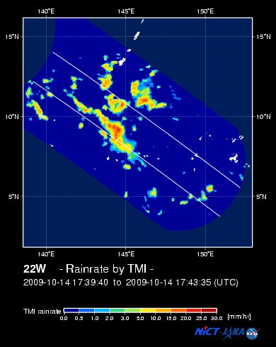
NASA-JAXA TMI Image: Latest Rainrate 01 [not updated]
EORC-JAXA TRMM Image: Latest Rainrate 02
Zoomed Satellite Pic: Near Real-Time
Wunderground Animation: 6-12 hr. GIF Loop
PHILIPPINE STORM WARNING SIGNAL # ONE (1)
Now In Effect: BATANES ISLAND GROUP, CAGAYAN, CALAYAN & BABUYAN ISLANDS, APAYAO, KALINGA, & ISABELA.
The above areas will have rains and winds of not more than 60 kph beginning tomorrow. Coastal waters will be moderate to rough.
Residents living in low-lying and mountainous areas under Public Storm Warning Signal Number 1 are alerted against flashfloods, mudflows, mudslides and landslides.
JTWC (US NAVY / AIR FORCE) 12, 24, 48 & 72 HR. FORECAST & REMARKS:
2 PM (06 GMT) 20 OCTOBER: 20.1N 129.6E / 175-215 KPH (TY-Cat 2) / W @ 17 KPH
<<<Typhoon2000.
Get the latest 6-hrly SMS Storm Alerts on RAMIL!
For more details: Text T2K TYPHOON to
2800 (Globe/TM) | 216 (Smart/TNT) | 2288 (Sun)
*only P2.50 (Smart/Globe) / P2.00 (Sun) per msg received.
powered by: Synermaxx
Typhoon2000 (T2K) NEWS (Tue October 20 2009):
Currently issuing 6-hrly advisories (except 12:00 AM) on TY LUPIT (RAMIL)
LUPIT (RAMIL) MAX WIND SPEED PER AGENCY:
+ USA (JTWC/1-min avg): 195 km/hr
+ Philippines (PAGASA/10-min avg): 195 km/hr
+ Beijing (NMC/2-min avg): 185 kph
+ Taiwan (CWB/10-min avg): 170 km/hr
+ Korea (KMA/10-min avg): 160 km/hr
+ Japan (JMA/10-min avg): 160 km/hr
TYPHOON LUPIT [RAMIL/22W/0920]
T2K PUBLIC ADVISORY NUMBER 018
6:00 AM PST (22:00 GMT) Tue 20 October 2009
Source: T2K ANALYSIS / JTWC WARNING #024
View: Advisory Archives (2004-2009)
*Residents and visitors along the Island of Luzon (particularly Northern Luzon) should closely monitor the progress of LUPIT (RAMIL).
*Kindly refer to your local warnings & bulletins issued by your country's official weather agency. This advisory is intended for additional information purposes only.
+ Forecast Outlook: LUPIT is expected to slightly decelerate and turn more westerly w/in the next 12 to 24 hours. Its wind speed will continue to decrease as it moves closer to Northern Luzon. The 2 to 5-day Long-Range Forecast shows LUPIT moving into a WSW direction, as the High Pressure Steering Ridge building off China strengthens. This ridge will steer LUPIT into Extreme Northern Luzon...making landfall over Eastern Cagayan on Thursday evening Oct 22...passing very close to the south of Aparri. The core (eye & eyewall) of LUPIT shall cross Abra, Kalinga and exit over Ilocos Sur whole day Friday Oct 23 and shall be over the South China Sea by early Saturday morning, Oct 24. It shall move westward to WNW while over the South China Sea, in the direction of Hainan Island-Vietnam Area on Sunday Oct 25. *Alternate Forecast Scenario: There is a possibility that LUPIT might track more WSW-ward earlier than expected with a strike across the southern part of Northern Luzon thru Isabela Province or Southern Cagayan. This scenario is likely if the high pressure steering ridge located off Eastern China strengthens more and dig deeper southward. The probability of this alternate forecast still remains low. Please be reminded that the Forecast Outlook changes every 6 hours, so a shift to the left or right of its future track and other conditions must be considered.
+ Effects: LUPIT's large circulation has deteriorated upon entering an area of drier air. The eye has become cloud-filled as shown on current satellite images. Its outer & inner rain bands remains at sea...not yet affecting any major islands at this time. LUPIT may begin to affect Northern Luzon beginning late Wednesday (Oct 21) - if the forecast movement continues, thus deteriorating weather conditions can be expected. 1-day rainfall accumulations of 75 up to 200 mm (moderate to heavy rain) can be expected along its rainbands...
Time/Date: 6:00 AM PST Tue October 20 2009
Location of Eye: 20.1º N Lat 130.7º E Lon
Distance 1: 910 km (492 nm) ESE of Basco, Batanes
Distance 2: 965 km (522 nm) ENE of Aparri, Cagayan
Distance 3: 985 km (532 nm) NE of Tuguegarao City
Distance 4: 990 km (535 nm) NE of Ilagan City
Distance 5: 1,005 km (542 nm) NE of Casiguran, Aurora
Distance 6: 1,075 km (580 nm) NE of Naga City
Distance 7: 1,190 km (642 nm) NE of Metro Manila
MaxWinds (1-min avg): 195 kph (105 kts) near the Eye
Peak Wind Gusts: 240 kph (130 kts)
Rainbands' Rain Rate: 2 to 30 mm/hr (.02 to 1.2 in/hr) new!
Saffir-Simpson Typhoon Scale: Category 3
Coastal Storm Surge Height: 9-12 feet [2.7-3.9 m]
Minimum Central Pressure: 944 millibars (hPa)
Recent Movement: WNW @ 17 kph (09 kts)
Projected Area of Impact: Extreme Northern Luzon
Size (in Diameter): 890 km (480 nm) / Very Large
Max Sea Wave Height (near center): 33 ft (10.0 m)
JTWC Ship Avoidance TrackMap: 2 AM Tue Oct 20
Multi-Agency Forecast TrackMap: 2 AM Tue Oct 20
TSR Wind Probabilities: Current to 5-days Ahead
NASA-JAXA TMI Image: Latest Rainrate 01 [not updated]
EORC-JAXA TRMM Image: Latest Rainrate 02
Zoomed Satellite Pic: Near Real-Time
Wunderground Animation: 6-12 hr. GIF Loop
PHILIPPINE STORM WARNING SIGNAL # ONE (1)
Now In Effect: BATANES ISLAND GROUP, CAGAYAN, CALAYAN & BABUYAN ISLANDS, APAYAO, KALINGA, & ISABELA.
The above areas will have rains and winds of not more than 60 kph beginning tomorrow. Coastal waters will be moderate to rough.
Residents living in low-lying and mountainous areas under Public Storm Warning Signal Number 1 are alerted against flashfloods, mudflows, mudslides and landslides.
2 PM (06 GMT) 20 OCTOBER: 20.1N 129.6E / 175-215 KPH (TY-Cat 2) / W @ 17 KPH
2 AM (18 GMT) 21 OCTOBER: 19.9N 127.7E / 185-230 KPH (TY-Cat 3) / WSW @ 17 KPH
2 AM (18 GMT) 22 OCTOBER: 18.8N 124.3E / 175-215 KPH (TY-Cat 2) / WSW @ 11 KPH
2 AM (18 GMT) 23 OCTOBER: 18.0N 121.7E / 150-185 KPH (TY-Cat 1) / WSW @ 11 KPH
2 AM (18 GMT) 22 OCTOBER: 18.8N 124.3E / 175-215 KPH (TY-Cat 2) / WSW @ 11 KPH
2 AM (18 GMT) 23 OCTOBER: 18.0N 121.7E / 150-185 KPH (TY-Cat 1) / WSW @ 11 KPH
REMARKS: 2 AM (18 GMT) TUE 20 OCTOBER POSITION: 19.8N 131.5E.
*THE CURRENT POSITION AND INTENSITY
ESTIMATES ARE CONSISTENT WITH RECENT DVORAK SATELLITE FIXES FROM
PGTW AND RJTD. TY 22W IS TRACKING EAST-NORTHEASTWARD UNDER THE
STEERING INFLUENCE OF A SUBTROPICAL RIDGE EXTENSION TO THE NORTHEAST
OF THE CYCLONE. THE TYPHOON WILL CONTINUE TO TRACK GENERALLY
WESTWARD IN THE CURRENT STEERING FLOW PATTERN FOR THE NEXT 24 HOURS.
THEREAFTER, THE FLOW ASSOCIATED WITH A SECOND SUBTROPICAL RIDGE TO
THE NORTHWEST WILL EXERT A SLIGHT EQUATORWARD PUSH. DURING THE NEXT
12 HOURS, TY 22W WILL WEAKEN SLIGHTLY AS IT MOVES THROUGH A NARROW
SLOT OF DRIER AND MORE STABLE AIR NOTED IN RECENT MICROWAVE
SATELLITE IMAGERY AND TOTAL PRECIPITABLE WATER PRODUCTS. AFTER TAU
12, HIGH ALONG TRACK OCEAN HEAT CONTENT, LOW VERTICAL WIND SHEAR,
AND GOOD UPPER LEVEL OUTFLOW WILL ALLOW THE SYSTEM TO MAINTAIN
INTENSITY OR PERHAPS INTENSIFY SLIGHTLY PRIOR TO MAKING LANDFALL IN
LUZON BETWEEN TAU 48 AND TAU 72. LAND INTERACTION AND DECREASING
POLEWARD OUTFLOW WILL WEAKEN TY 22W BETWEEN TAU 48 AND TAU 96. AS
THE STORM ENTERS THE SOUTH CHINA SEA, UPPER LEVEL SUPPORT SHOULD
IMPROVE ONCE AGAIN, HALTING THIS WEAKENING TREND...(more)
>> LUPIT, meaning: Cruel; viciousness. Name contributed by: Philippines.
____________
PAGASA CURRENT POSITION, MOVEMENT AND INTENSITY (10-min. ave.):
> 4 AM (20 GMT) 20 OCTOBER: 20.0N 131.1E / WEST @ 17 kph / 195 kph
:: For the complete PAGASA bulletin, kindly visit their website at:
http://www.pagasa.dost.gov.ph/wb/tcupdate.shtml
_______________________________________________________________________________________________________________________________________
:: For the complete PAGASA bulletin, kindly visit their website at:
http://www.pagasa.
____________
RECENT TYPHOON2000.

________________________
RECENT MTSAT-1R SATELLITE IMAGE:

> Image source: NOAA SATELLITE CENTER
RECENT WUNDERGROUND SATELLITE ANIMATION:

> Image source: Wunderground.com (http://www.wunderground.com/ ) ____________________________________________________________________________________________________________________
> Image source: NOAA SATELLITE CENTER
____________________________________________________________________________________________________________________
RECENT WUNDERGROUND SATELLITE ANIMATION:
> Image source: Wunderground.
NOTE:
^ - JTWC commentary remarks (for Meteorologists) from their latest warning.
__________________________________________________________________________________________
>> To know the meteorological terminologies and acronyms used on this update visit the ff:
http://typhoon2000.ph/tcterm.htm
http://www.nhc.noaa.gov/aboutgloss.shtml
http://www.srh.noaa.gov/oun/severewx/glossary.php
http://www.srh.weather.gov/fwd/glossarynation.html
http://www.nhc.noaa.gov/acronyms.shtml
__________________________________________________________________________________________
For the complete details on TY LUPIT (RAMIL)...go visit our website @:
> http://www.typhoon2000.com
> http://www.maybagyo.com
>> To know the meteorological terminologies and acronyms used on this update visit the ff:
http://typhoon2000.
http://www.nhc.
http://www.srh.
http://www.srh.
http://www.nhc.
____________
> http://www.typhoon2
> http://www.maybagyo
Copyright © 2009 Typhoon2000.
__._,_.___
Change settings via the Web (Yahoo! ID required)
Change settings via email: Switch delivery to Daily Digest | Switch format to Traditional
Visit Your Group | Yahoo! Groups Terms of Use | Unsubscribe
.
__,_._,___

No comments:
Post a Comment