

<<<Typhoon2000.
Get the latest 3-hrly SMS Storm Alerts on PEPENG!
For more details: Text T2K TYPHOON to
2800 (Globe/TM) | 216 (Smart/TNT) | 2288 (Sun)
*only P2.50 (Smart/Globe) / P2.00 (Sun) per msg received.
powered by: Synermaxx
Typhoon2000 (T2K) NEWS (Tue October 06 2009):
PARMA expected to make landfall off Pagudpud, Ilocos Norte or along the boundary of Ilocos Norte-Cagayan in the next hour or so! Full preparation is a must!...Currently issuing 3-hrly SMS updates and 6-hrly advisories (except 12:00 AM) on TS PARMA (PEPENG).
PARMA (PEPENG) MAX WIND SPEED PER AGENCY:
+ Korea (KMA/10-min avg): 110 km/hr
+ Japan (JMA/10-min avg): 110 km/hr
+ Hong Kong (HKO/10-min avg): 110 km/hr
+ Philippines (PAGASA/10-min avg): 105 km/hr
+ Beijing (NMC/2-min avg): 100 kph
+ Taiwan (CWB/10-min avg): 100 km/hr
+ USA (JTWC/1-min avg): 100 km/hr
TROPICAL STORM PARMA [PEPENG/19W/
T2K PUBLIC ADVISORY NUMBER 028
6:00 PM PST (10:00 GMT) Tue 06 October 2009
Source: T2K ANALYSIS / JTWC WARNING #035
View: Advisory Archives (2004-2009)
*Residents and visitors along Northern Luzon should closely monitor the progress of PARMA.
*Kindly refer to your local warnings & bulletins issued by your country's official weather agency. This advisory is intended for additional information purposes only.
+ Forecast Outlook: PARMA is expected to continue moving SE-ward to SSE crossing between Ilocos Norte-Western Cagayan and Apayao in the next few hours. It shall be off Ilocos Sur tomorrow afternoon or evening. The 2 to 5-day Long-Range Forecast shows PARMA turning SW-ward and moving back into the South China Sea on Thursday afternoon Oct 08, and accelerating Westward and intensifying on Friday Oct 09 thru Sunday Oct 11.
+ Effects: PARMA's main circulation is now covering the northern part of Luzon...Stormy conditions w/ winds not exceeding 130 kph can be expected along Ilocos Provinces and portions of Extreme Northern Luzon...while its inner (rain) bands spreading across other parts of Northern Luzon - where deteriorating weather conditions w/ winds not exceeding 85 kph can be expected tonight. Northern parts of Central Luzon will be under PARMA's outer (feeder) bands), where cloudy skies, light to moderate rains w/ winds not exceeding 60 kph can be expected. 1-day rainfall accumulations of 50 up to 100 mm (moderate to heavy rain) can be expected along PARMA's rainbands...
+ Tropical Cyclone Watch:
(1) Typhoon MELOR (QUEDAN) now exiting PAR...shall recurve later towards Southern Japan. Click here to view latest T2K advisory.
Kindly click the cool T2K Graphical Satellite Analysis, issued every afternoon, and shows various tropical systems roaming across the South China Sea and the Western Pacific Ocean.
[Important Note: Please keep in mind that the above forecast outlook, effects, current monsoon intensity, & tropical cyclone watch changes every 6 to 12 hrs!]
Time/Date: 6:00 PM PST Tue October 06 2009
Location of Center: 18.7º N Lat 120.8º E Lon
Distance 1: 15 km (08 nm) NNE of Pagudpud, Ilocos Norte
Distance 2: 60 km (33 nm) NNE of Laoag City
Distance 3: 100 km (55 nm) WNW of Aparri, Cagayan
Distance 4: 130 km (70 nm) NNE of Vigan City
Distance 5: 240 km (130 nm) NNE of San Fernando City
Distance 6: 255 km (138 nm) North of Baguio City
Distance 7: 305 km (165 nm) NNE of Dagupan City
Distance 8: 455 km (245 nm) North of Metro Manila
MaxWinds (1-min avg): 110 kph (65 kts) near the eye
Peak Wind Gusts: 140 kph (75 kts)
Saffir-Simpson Typhoon Scale: Tropical Storm
Coastal Storm Surge Height: 1-3 feet [0.3-0.9 m]
Minimum Central Pressure: 978 millibars (hPa)
Recent Movement: SE @ 11 kph (06 kts)
Projected Area of Impact: Ilocos Norte-Apayao-
Size (in Diameter): 650 km (350 nm) / Average
Max Sea Wave Height (near center): 31 ft (9.4 m)
T2K TrackMap #013 (for Public): 6 PM PST Tue Oct 06
JTWC Ship Avoidance TrackMap: 2 PM Tue Oct 6
Multi-Agency Forecast TrackMap: 5 PM Tue Oct 6
TSR Wind Probabilities: Current to 5-days Ahead
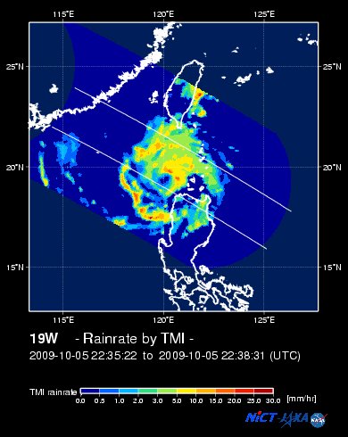
EORC-JAXA TRMM Viewer: Real-Time Rainrate Image
NASA-JAXA TMI Viewer: Latest Rainrate Image
Zoomed Satellite Pic: Near Real-Time
Wunderground Animation: 6-12 hr. GIF Loop
PHILIPPINE STORM SIGNAL # THREE (3) 
Now In Effect: ILOCOS NORTE, ILOCOS SUR, ABRA NORTHERN CAGAYAN, BATANES, BABUYAN & CALAYAN ISLAND GROUP, & APAYAO.
PHILIPPINE STORM WARNING SIGNAL # TWO (2)
Now In Effect: REST OF CAGAYAN, KALINGA, MOUNTAIN PROVINCE, BENGUET, & LA UNION.
The above areas will experience stormy weather tonight and tomorrow (with winds not exceeding 100 kph for #02 and more than 100 kph for #03). Coastal waters will be rough to very rough and extremely dangerous to all types of seacrafts.
PHILIPPINE STORM WARNING SIGNAL # ONE (1)
Now In Effect: ISABELA, IFUGAO, NUEVA VIZCAYA & PANGASINAN.
The above areas will have rains and winds of not more than 60 kph tonight and tomorrow. Coastal waters will be moderate to rough.
Residents living in low-lying and mountainous areas under Public Storm Warning Signal Numbers 3, 2 & 1 are alerted against flashfloods, mudflows, mudslides and landslides.
________________________

> Image source: NOAA SATELLITE CENTER
RECENT WUNDERGROUND SATELLITE ANIMATION:
> Image source: Wunderground.
>> To know the meteorological terminologies and acronyms used on this update visit the ff:
http://typhoon2000.
http://www.nhc.
http://www.srh.
http://www.srh.
http://www.nhc.
____________
> http://www.typhoon2
> http://www.maybagyo
Copyright © 2009 Typhoon2000.
Change settings via the Web (Yahoo! ID required)
Change settings via email: Switch delivery to Daily Digest | Switch format to Traditional
Visit Your Group | Yahoo! Groups Terms of Use | Unsubscribe

No comments:
Post a Comment