
for Friday, 16 October 2009 [5:57 AM PST]


<<<Typhoon2000.com Mobile >>>
Get the latest 6-hrly SMS Storm Alerts on Pre-RAMIL!
For more details: Text T2K TYPHOON to
2800 (Globe/TM) | 216 (Smart/TNT) | 2288 (Sun)
*only P2.50 (Smart/Globe) / P2.00 (Sun) per msg received.
powered by: Synermaxx
Typhoon2000 (T2K) NEWS (Fri October 16 2009):
Currently issuing 6-hrly advisories (except 12:00 AM) on the newly-formed TS LUPIT (PRE-RAMIL)
LUPIT (PRE-RAMIL) MAX WIND SPEED PER AGENCY:
+ USA (JTWC/1-min avg): 100 km/hr
+ Beijing (NMC/2-min avg): 65 kph
-->+ Japan (JMA/10-min avg): 65 km/hr
+ Korea (KMA/10-min avg): 65 km/hr
+ Taiwan (CWB/10-min avg): 65 km/hr
TROPICAL STORM LUPIT [PRE-RAMIL/22W/0920]
T2K PUBLIC ADVISORY NUMBER 006
6:00 AM PST (22:00 GMT) Fri 16 October 2009
Source: T2K ANALYSIS / JTWC WARNING #008
View: Advisory Archives (2004-2009)
Tropical Storm 22W is now known internationally as LUPIT...gaining more strength as it tracks WNW across the Pacific Ocean...approaching the Philippine Area of Responsibility (PAR)...may threaten Luzon early next week.
*Residents and visitors along Northern & Central Luzon should closely monitor the progress of LUPIT.
*Kindly refer to your local warnings & bulletins issued by your country's official weather agency. This advisory is intended for additional information purposes only.
+ Forecast Outlook: LUPIT is expected to slow down as it continues moving WNW, entering the Philippine Area of Responsibility (PAR) late tonight or early tomorrow morning. It will become a Typhoon soon. The 2 to 5-day Long-Range Forecast shows LUPIT executing a very slow NW'ly turn tomorrow until Sunday (Oct 17-18)...this is due to a passing middle-latitude low pressure area (trough) north of it. Then, on Monday Oct 19th, LUPIT shall resume its west or WNW track towards Northern Luzon. This storm shall rapidly grow into a Category 4 Typhoon w/ winds of 230 kph on Wednesday Oct 21st. *Initial Impact Forecast (IIF): LUPIT shall make landfall over Isabela-Cagayan Area on Wednesday, Oct 21 and exit thru Ilocos Provinces in the evening (Oct 21). It shall be approaching Hainan Island on Saturday or Sunday (Oct 24-25). This scenario was taken from the latest forecast run of ECMF (European Guidance Model), which is the most reliable forecast tool this season. Please be reminded that the ECMWF model run changes every 12 hours, so a shift to the left or right of its future track and other conditions must be considered.
+ Effects: LUPIT's broad circulation shrinking a little as it becomes better organized. Its southern outer feeder bands spreading across Ulithi and Yap Islands - where squall conditions can be expected today. 1-day rainfall accumulations of 50 up to 100 mm (moderate to heavy rain) can be expected along its rainbands...with isolated accumulations of up to 200 mm (very heavy rain) near the center of LUPIT particularly along its projected path.
+ Tropical Cyclone Watch:
(1) Tropical Disturbance 93W (LPA) has started to consolidate near the coast of Vietnam...outside of P.A.R...currently located near lat 14.8N lon 112.2E...or about 450 km ESE of Da Nang, Vietnam...with 1-min maximum sustained winds of 35 kph near the center...moving West @ 20 kph towards Vietnam. This system has the potential of becoming a weak Tropical Cyclone within the next 2 days.
Kindly click the T2K Graphical Satellite Analysis, issued every afternoon, and shows various tropical systems roaming across the South China Sea and the Western Pacific Ocean.
[Important Note: Please keep in mind that the above forecast outlook, effects, current monsoon intensity, & tropical cyclone watch changes every 6 to 12 hrs!]
Time/Date:6:00 AM PST Fri October 16 2009
Location of Center: 12.8º N Lat 138.3º E Lon
Distance 1: 370 km (200 nm) North of Yap, FSM
Distance 2: 360 km (195 nm) East of P.A.R.
Distance 3: 1,520 km (820 nm) ESE of Virac, Catanduanes
Distance 4: 1,635 km (883 nm) ESE of Metro Naga/CWC
Distance 5: 1,870 km (1,010 nm) ESE of Metro Manila
MaxWinds (1-min avg): 100 kph (55 kts) near the center
Peak Wind Gusts: 130 kph (70 kts)
Saffir-Simpson Typhoon Scale: Tropical Storm
Coastal Storm Surge Height: 1-3 feet [0.3-0.9 m]
Minimum Central Pressure: 982 millibars (hPa)
Recent Movement: WNW @ 33 kph (18 kts)
Projected Area of Impact: Philippine Sea
Size (in Diameter): 520 km (280 nm) / Average
Max Sea Wave Height (near center): 16 ft (4.8 m)
T2K TrackMap #004 (for Public): 6 AM PST Fri Oct 16
JTWC Ship Avoidance TrackMap: 2 AM Fri Oct 16
Multi-Agency Forecast TrackMap: 2 AM Fri Oct 16
TSR Wind Probabilities: Current to 5-days Ahead
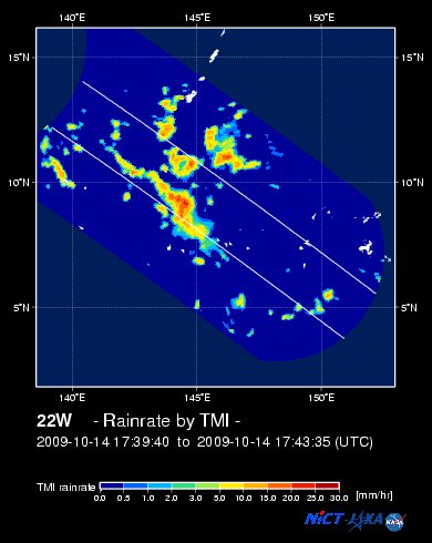
NASA-JAXA TMI Image: Latest Rainrate 01
Zoomed Satellite Pic: Near Real-Time
Wunderground Animation: 6-12 hr. GIF Loop
JTWC (US NAVY/AIR FORCE) 12, 24, 48 & 72 HR. FORECAST & REMARKS:
2 PM (06 GMT) 16 OCTOBER: 13.2N 135.6E / 120-150 KPH (TY-Cat 1) / WNW @ 17 KPH
<<<Typhoon2000.
Get the latest 6-hrly SMS Storm Alerts on Pre-RAMIL!
For more details: Text T2K TYPHOON to
2800 (Globe/TM) | 216 (Smart/TNT) | 2288 (Sun)
*only P2.50 (Smart/Globe) / P2.00 (Sun) per msg received.
powered by: Synermaxx
Typhoon2000 (T2K) NEWS (Fri October 16 2009):
Currently issuing 6-hrly advisories (except 12:00 AM) on the newly-formed TS LUPIT (PRE-RAMIL)
LUPIT (PRE-RAMIL) MAX WIND SPEED PER AGENCY:
+ USA (JTWC/1-min avg): 100 km/hr
+ Beijing (NMC/2-min avg): 65 kph
-->+ Japan (JMA/10-min avg): 65 km/hr
+ Korea (KMA/10-min avg): 65 km/hr
+ Taiwan (CWB/10-min avg): 65 km/hr
TROPICAL STORM LUPIT [PRE-RAMIL/22W/
T2K PUBLIC ADVISORY NUMBER 006
6:00 AM PST (22:00 GMT) Fri 16 October 2009
Source: T2K ANALYSIS / JTWC WARNING #008
View: Advisory Archives (2004-2009)
*Residents and visitors along Northern & Central Luzon should closely monitor the progress of LUPIT.
*Kindly refer to your local warnings & bulletins issued by your country's official weather agency. This advisory is intended for additional information purposes only.
+ Forecast Outlook: LUPIT is expected to slow down as it continues moving WNW, entering the Philippine Area of Responsibility (PAR) late tonight or early tomorrow morning. It will become a Typhoon soon. The 2 to 5-day Long-Range Forecast shows LUPIT executing a very slow NW'ly turn tomorrow until Sunday (Oct 17-18)...this is due to a passing middle-latitude low pressure area (trough) north of it. Then, on Monday Oct 19th, LUPIT shall resume its west or WNW track towards Northern Luzon. This storm shall rapidly grow into a Category 4 Typhoon w/ winds of 230 kph on Wednesday Oct 21st. *Initial Impact Forecast (IIF): LUPIT shall make landfall over Isabela-Cagayan Area on Wednesday, Oct 21 and exit thru Ilocos Provinces in the evening (Oct 21). It shall be approaching Hainan Island on Saturday or Sunday (Oct 24-25). This scenario was taken from the latest forecast run of ECMF (European Guidance Model), which is the most reliable forecast tool this season. Please be reminded that the ECMWF model run changes every 12 hours, so a shift to the left or right of its future track and other conditions must be considered.
+ Effects: LUPIT's broad circulation shrinking a little as it becomes better organized. Its southern outer feeder bands spreading across Ulithi and Yap Islands - where squall conditions can be expected today. 1-day rainfall accumulations of 50 up to 100 mm (moderate to heavy rain) can be expected along its rainbands...
(1) Tropical Disturbance 93W (LPA) has started to consolidate near the coast of Vietnam...outside of P.A.R...currently located near lat 14.8N lon 112.2E...or about 450 km ESE of Da Nang, Vietnam...with 1-min maximum sustained winds of 35 kph near the center...moving West @ 20 kph towards Vietnam. This system has the potential of becoming a weak Tropical Cyclone within the next 2 days.
Kindly click the T2K Graphical Satellite Analysis, issued every afternoon, and shows various tropical systems roaming across the South China Sea and the Western Pacific Ocean.
[Important Note: Please keep in mind that the above forecast outlook, effects, current monsoon intensity, & tropical cyclone watch changes every 6 to 12 hrs!]
Time/Date:6:00 AM PST Fri October 16 2009
Location of Center: 12.8º N Lat 138.3º E Lon
Distance 1: 370 km (200 nm) North of Yap, FSM
Distance 2: 360 km (195 nm) East of P.A.R.
Distance 3: 1,520 km (820 nm) ESE of Virac, Catanduanes
Distance 4: 1,635 km (883 nm) ESE of Metro Naga/CWC
Distance 5: 1,870 km (1,010 nm) ESE of Metro Manila
MaxWinds (1-min avg): 100 kph (55 kts) near the center
Peak Wind Gusts: 130 kph (70 kts)
Saffir-Simpson Typhoon Scale: Tropical Storm
Coastal Storm Surge Height: 1-3 feet [0.3-0.9 m]
Minimum Central Pressure: 982 millibars (hPa)
Recent Movement: WNW @ 33 kph (18 kts)
Projected Area of Impact: Philippine Sea
Size (in Diameter): 520 km (280 nm) / Average
Max Sea Wave Height (near center): 16 ft (4.8 m)
T2K TrackMap #004 (for Public): 6 AM PST Fri Oct 16
JTWC Ship Avoidance TrackMap: 2 AM Fri Oct 16
Multi-Agency Forecast TrackMap: 2 AM Fri Oct 16
TSR Wind Probabilities: Current to 5-days Ahead
NASA-JAXA TMI Image: Latest Rainrate 01
Zoomed Satellite Pic: Near Real-Time
Wunderground Animation: 6-12 hr. GIF Loop
2 PM (06 GMT) 16 OCTOBER: 13.2N 135.6E / 120-150 KPH (TY-Cat 1) / WNW @ 17 KPH
2 AM (18 GMT) 17 OCTOBER: 13.8N 133.9E / 140-165 KPH (TY-Cat 1) / WNW @ 11 KPH
2 AM (18 GMT) 18 OCTOBER: 14.8N 132.3E / 175-215 KPH (TY-Cat 2) / NW @ 09 KPH
2 AM (18 GMT) 19 OCTOBER: 15.9N 130.5E / 205-250 KPH (TY-Cat 3) / WNW @ 13 KPH
2 AM (18 GMT) 18 OCTOBER: 14.8N 132.3E / 175-215 KPH (TY-Cat 2) / NW @ 09 KPH
2 AM (18 GMT) 19 OCTOBER: 15.9N 130.5E / 205-250 KPH (TY-Cat 3) / WNW @ 13 KPH
REMARKS: 2 AM (18 GMT) FRI 16 OCTOBER POSITION: 12.7N 138.7E.
*TROPICAL STORM (TS) 22W (LUPIT) IS LOCATED APPROXIMATELY 170 NM
NORTH OF YAP AND HAS TRACKED WESTWARD ALONG THE SOUTHERN PERIPHERY
OF THE SUBTROPICAL RIDGE (STR) AT 18 KNOTS OVER THE PAST SIX HOURS.
ANIMATED INFRARED IMAGERY SHOWS A BAND OF DEEP CONVECTION WRAPPING
TIGHTLY INTO THE LOW LEVEL CIRCULATION CENTER (LLCC). ANIMATED WATER
VAPOR IMAGERY ALSO DEPICTS VERY GOOD RADIAL OUTFLOW. AS SUCH, THE
SYSTEM HAS STEADILY INTENSIFIED OVER THE LAST 12 HOURS AND IS NOW AT
55 KNOTS. THE CURRENT INTENSITY IS BASED ON DVORAK SATELLITE
ESTIMATES FROM PGTW AND KNES (T3.5) AS WELL AS A 151730Z SATCON
AUTOMATED DVORAK VALUE OF T3.4. A 151615Z AMSRE 89 GHZ MICROWAVE
SATELLITE IMAGE SHOWS A WELL-DEFINED BAND OF DEEP CONVECTION
WRAPPING INTO THE LLCC. TS 22W IS EXPECTED TO TRACK GENERALLY WEST-
NORTHWESTWARD ALONG THE SOUTHERN PERIPHERY OF THE STR OVER THE NEXT
24 TO 36 HOURS. BY TAU 36, THE SYSTEM IS EXPECTED TO SLOW IN FORWARD
TRACK SPEED AND MOVE POLEWARD SLIGHTLY AS A MID-LATITUDE TROUGH
TEMPORARILY WEAKENS THE SUBTROPICAL STEERING RIDGE. TS 22W WILL
REMAIN IN A FAVORABLE ENVIRONMENT CHARACTERIZED BY MINIMAL VERTICAL
WIND SHEAR, GOOD RADIAL OUTFLOW AND HIGH OCEAN HEAT CONTENT. BY TAU
72, TS 22W SHOULD RESUME ITS WESTWARD TRACK UNDER THE INFLUENCE OF
A WESTERN LOBE OF THE STR LOCATED BEHIND THE TROUGH. AS TS 22W
CONTINUES THROUGH THE PHILIPPINE SEA, THE SYSTEM SHOULD CONTINUE TO
STEADILY INTENSIFY AS THE ENVIRONMENT IS FORECAST TO REMAIN
FAVORABLE. THIS FORECAST LEANS TOWARD THE JTWC CONSENSUS AND ECMWF
SOLUTIONS WHICH CALL FOR THE TROUGH TO WEAKEN THE STEERING INFLUENCE
OF THE SUB-TROPICAL RIDGE AND SLOW THE SYSTEM'S FORWARD SPEED
BETWEEN TAUS 36 AND 72...(more)
>> LUPIT, meaning: Cruel; viciousness. Name contributed by: Philippines.
____________
_______________________________________________________________________________________________________________________________________
RECENT TYPHOON2000.

________________________
RECENT MTSAT-1R SATELLITE IMAGE:

> Image source: NOAA SATELLITE CENTER
RECENT WUNDERGROUND SATELLITE ANIMATION:

> Image source: Wunderground.com (http://www.wunderground.com/ ) ____________________________________________________________________________________________________________________
> Image source: NOAA SATELLITE CENTER
____________________________________________________________________________________________________________________
RECENT WUNDERGROUND SATELLITE ANIMATION:
> Image source: Wunderground.
NOTE:
^ - JTWC commentary remarks (for Meteorologists) from their latest warning.
__________________________________________________________________________________________
>> To know the meteorological terminologies and acronyms used on this update visit the ff:
http://typhoon2000.ph/tcterm.htm
http://www.nhc.noaa.gov/aboutgloss.shtml
http://www.srh.noaa.gov/oun/severewx/glossary.php
http://www.srh.weather.gov/fwd/glossarynation.html
http://www.nhc.noaa.gov/acronyms.shtml
__________________________________________________________________________________________
For the complete details on TS LUPIT (22W)...go visit our website @:
> http://www.typhoon2000.com
> http://www.maybagyo.com
>> To know the meteorological terminologies and acronyms used on this update visit the ff:
http://typhoon2000.
http://www.nhc.
http://www.srh.
http://www.srh.
http://www.nhc.
____________
> http://www.typhoon2
> http://www.maybagyo
Copyright © 2009 Typhoon2000.
__._,_.___
Change settings via the Web (Yahoo! ID required)
Change settings via email: Switch delivery to Daily Digest | Switch format to Traditional
Visit Your Group | Yahoo! Groups Terms of Use | Unsubscribe
.
__,_._,___

No comments:
Post a Comment