
for Thursday, 22 October 2009 [6:30 PM PST]


<<<Typhoon2000.com Mobile >>>
Get the latest 6-hrly SMS Storm Alerts on RAMIL!
For more details: Text T2K TYPHOON to
2800 (Globe/TM) | 216 (Smart/TNT) | 2288 (Sun)
*only P2.50 (Smart/Globe) / P2.00 (Sun) per msg received.
powered by: Synermaxx
Typhoon2000 (T2K) NEWS (Wed October 21 2009):
Continuing issuing 6-hrly advisories (except 12:00 AM) on TY LUPIT (RAMIL)
LUPIT (RAMIL) MAX WIND SPEED PER AGENCY:
+ Philippines (PAGASA/10-min avg): 160 km/hr
+ Beijing (NMC/2-min avg): 145 kph
+ Hong Kong (HKO/10-min avg): 140 km/hr
+ Korea (KMA/10-min avg): 140 km/hr
+ Japan (JMA/10-min avg): 130 km/hr
+ Taiwan (CWB/10-min avg): 125 km/hr
+ USA (JTWC/1-min avg): 120 km/hr
TYPHOON LUPIT [RAMIL/22W/0920]
T2K PUBLIC ADVISORY NUMBER 026
6:00 PM PST (10:00 GMT) Thu 22 October 2009
Source: T2K ANALYSIS / JTWC WARNING #034
View: Advisory Archives (2004-2009)
LUPIT (RAMIL) loses strength, barely a Typhoon as it continues moving very slowly. High hopes are now on all forecast models as the system may likely track towards the north and spare Northern Luzon this weekend.
*Residents and visitors along Extreme Northern Luzon & Taiwan should closely monitor the progress of LUPIT (RAMIL).
*Kindly refer to your local warnings & bulletins issued by your country's official weather agency. This advisory is intended for additional information purposes only.
+ Forecast Outlook: LUPIT is expected to continue decelerating further to just 2 kph while moving Westward w/in the next 24 to 48 hours. Its wind speed will slightly re-intensify as it moves closer near the coast of Cagayan. The 2 to 5-day Long-Range Forecast shows LUPIT still at a snail-pace motion as it begins turning WNW into the Balintang Channel, passing north of Cagayan on Monday until Tuesday (Oct 26-27). *Alternate Forecast Scenario: There is a strong possibility that LUPIT might track abruptly Northward and recurve towards Southern Japan, sparing Extreme Northern Luzon. The probability of this alternate forecast remains high, as majority of various numerical guidance models depicts this scenario. Please be reminded that the Forecast Outlook changes every 6 hours, so a turn to the left or right of its future track and other conditions must be considered. So please stay tuned.
+ Effects: LUPIT's circulation has deteriorated during the past 6 hours. A surge of dry air entered the system along the northwest portion which caused the weakening to just minimal Typhoon intensity (120 kph). The core and its inner rainbands remains at sea with its outer rainbands continues to affect Cagayan, Isabela & Aurora. Cloudy skies w/ light passing rains & winds not exceeding 55 kph can be expected along these bands. 1-day rainfall accumulations of 75 up to 150 mm (moderate to heavy rain) can be expected along its rainbands...with isolated accumulations of 300 mm or more (very heavy to extreme rain) near the center of LUPIT particularly along its projected path. Residents in low-lying areas & steep slopes must remain alert & seek evacuation for possible life-threatening flash floods, mudslides & landslides due to the anticipated heavy rains brought about by this system. Precautionary measures must be initiated if necessary. Possible coastal Storm Surge flooding of 4 to 5 feet above normal tide levels...accompanied by large and dangerous battering waves...is possible along the coastal areas of Extreme Northern Luzon especially along Cagayan, Batanes-Calayan-Babuyan Island Group, Isabela & Ilocos Norte. Very minimal damage is likely on this type of storm surge. Danger from Rip Currents or Rip Tides can be expected along the beach-front areas of Northern Luzon & Taiwan.
[Important Note: Please keep in mind that the above forecast outlook, effects, current monsoon intensity, & tropical cyclone watch changes every 6 to 12 hrs!]
Time/Date: 6:00 PM PST Thu October 22 2009
Location of Eye: 18.7º N Lat 124.2º E Lon
Distance 1: 265 km (143 nm) ENE of Aparri, Cagayan
Distance 2: 290 km (157 nm) ESE of Calayan Island
Distance 3: 295 km (160 nm) NE of Tuguegarao City
Distance 4: 300 km (162 nm) NE of Basco, Batanes
Distance 5: 310 km (167 nm) NE of Ilagan City
Distance 6: 385 km (208 nm) ENE of Laoag City
Distance 7: 570 km (308 nm) NNE of Metro Manila
Distance 8: 590 km (318 nm) NNE of Naga City
MaxWinds (1-min avg): 120 kph (65 kts) near the Eye
Peak Wind Gusts: 150 kph (80 kts)
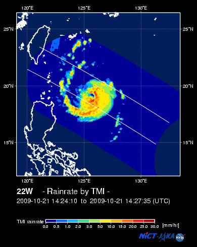
Rainbands' Rain Rate: 2 to 30 mm/hr (.02 to 1.2 in/hr) new!
Saffir-Simpson Typhoon Scale: Category 1
Coastal Storm Surge Height: 4-5 feet [1.2-1.7 m]
Minimum Central Pressure: 974 millibars (hPa)
Recent Movement: West @ 09 kph (05 kts)
Projected Area of Impact: Calayan-Babuyan Islands
Size (in Diameter): 925 km (500 nm) / Very Large
Max Sea Wave Height (near center): 32 ft (9.7 m)
T2K TrackMap #024 (for Public): 6 PM PST Thu Oct 22
JTWC Ship Avoidance TrackMap: 2 PM Thu Oct 22
Multi-Agency Forecast TrackMap: 2 PM Thu Oct 22
TSR Wind Probabilities: Current to 5-days Ahead
NASA-JAXA TMI Image: Latest Rainrate 01
EORC-JAXA TRMM Image: Latest Rainrate 02
Zoomed Satellite Pic: Near Real-Time
Wunderground Animation: 6-12 hr. GIF Loop
PHILIPPINE STORM SIGNAL # THREE (3)
In Effect: BATANES GROUP, CAGAYAN, CALAYAN & BABUYAN ISLANDS, APAYAO, & ILOCOS NORTE.
PHILIPPINE STORM WARNING SIGNAL # TWO (2)
In Effect: ILOCOS SUR, KALINGA, ISABELA, ABRA, MT. PROVINCE, IFUGAO, BENGUET, LA UNION, NUEVA VIZCAYA, QUIRINO, & AURORA.
The above areas will experience stormy weather beginning tonight or tomorrow (with winds not exceeding 100 kph for #02 and more than 100 kph for #03). Coastal waters will be rough to very rough and extremely dangerous to all types of seacrafts.
PHILIPPINE STORM WARNING SIGNAL # ONE (1)
In Effect: PANGASINAN, TARLAC, NUEVA ECIJA, ZAMBALES, PAMPANGA, BULACAN, NORTHERN QUEZON, & POLILLO ISLANDS.
The above areas will have rains and winds of not more than 60 kph beginning tonight or tomorrow. Coastal waters will be moderate to rough.
Residents living in low-lying and mountainous areas under Public Storm Warning Signal Numbers 3, 2 & 1 are alerted against flashfloods, mudflows, mudslides and landslides...while those living in coastal & beach-front areas are advised to seek higher grounds due to possible storm surge (aka. big waves) that could reach a high of 5 feet or more.
JTWC (US NAVY / AIR FORCE) 12, 24, 48 & 72 HR. FORECAST & REMARKS:
2 AM (18 GMT) 23 OCTOBER: 18.8N 123.9E / 120-150 KPH (TY-Cat 1) / W @ 04 KPH
<<<Typhoon2000.
Get the latest 6-hrly SMS Storm Alerts on RAMIL!
For more details: Text T2K TYPHOON to
2800 (Globe/TM) | 216 (Smart/TNT) | 2288 (Sun)
*only P2.50 (Smart/Globe) / P2.00 (Sun) per msg received.
powered by: Synermaxx
Typhoon2000 (T2K) NEWS (Wed October 21 2009):
Continuing issuing 6-hrly advisories (except 12:00 AM) on TY LUPIT (RAMIL)
LUPIT (RAMIL) MAX WIND SPEED PER AGENCY:
+ Philippines (PAGASA/10-min avg): 160 km/hr
+ Beijing (NMC/2-min avg): 145 kph
+ Hong Kong (HKO/10-min avg): 140 km/hr
+ Korea (KMA/10-min avg): 140 km/hr
+ Japan (JMA/10-min avg): 130 km/hr
+ Taiwan (CWB/10-min avg): 125 km/hr
+ USA (JTWC/1-min avg): 120 km/hr
TYPHOON LUPIT [RAMIL/22W/0920]
T2K PUBLIC ADVISORY NUMBER 026
6:00 PM PST (10:00 GMT) Thu 22 October 2009
Source: T2K ANALYSIS / JTWC WARNING #034
View: Advisory Archives (2004-2009)
*Residents and visitors along Extreme Northern Luzon & Taiwan should closely monitor the progress of LUPIT (RAMIL).
*Kindly refer to your local warnings & bulletins issued by your country's official weather agency. This advisory is intended for additional information purposes only.
+ Forecast Outlook: LUPIT is expected to continue decelerating further to just 2 kph while moving Westward w/in the next 24 to 48 hours. Its wind speed will slightly re-intensify as it moves closer near the coast of Cagayan. The 2 to 5-day Long-Range Forecast shows LUPIT still at a snail-pace motion as it begins turning WNW into the Balintang Channel, passing north of Cagayan on Monday until Tuesday (Oct 26-27). *Alternate Forecast Scenario: There is a strong possibility that LUPIT might track abruptly Northward and recurve towards Southern Japan, sparing Extreme Northern Luzon. The probability of this alternate forecast remains high, as majority of various numerical guidance models depicts this scenario. Please be reminded that the Forecast Outlook changes every 6 hours, so a turn to the left or right of its future track and other conditions must be considered. So please stay tuned.
+ Effects: LUPIT's circulation has deteriorated during the past 6 hours. A surge of dry air entered the system along the northwest portion which caused the weakening to just minimal Typhoon intensity (120 kph). The core and its inner rainbands remains at sea with its outer rainbands continues to affect Cagayan, Isabela & Aurora. Cloudy skies w/ light passing rains & winds not exceeding 55 kph can be expected along these bands. 1-day rainfall accumulations of 75 up to 150 mm (moderate to heavy rain) can be expected along its rainbands...
Time/Date: 6:00 PM PST Thu October 22 2009
Location of Eye: 18.7º N Lat 124.2º E Lon
Distance 1: 265 km (143 nm) ENE of Aparri, Cagayan
Distance 2: 290 km (157 nm) ESE of Calayan Island
Distance 3: 295 km (160 nm) NE of Tuguegarao City
Distance 4: 300 km (162 nm) NE of Basco, Batanes
Distance 5: 310 km (167 nm) NE of Ilagan City
Distance 6: 385 km (208 nm) ENE of Laoag City
Distance 7: 570 km (308 nm) NNE of Metro Manila
Distance 8: 590 km (318 nm) NNE of Naga City
MaxWinds (1-min avg): 120 kph (65 kts) near the Eye
Peak Wind Gusts: 150 kph (80 kts)
Rainbands' Rain Rate: 2 to 30 mm/hr (.02 to 1.2 in/hr) new!
Saffir-Simpson Typhoon Scale: Category 1
Coastal Storm Surge Height: 4-5 feet [1.2-1.7 m]
Minimum Central Pressure: 974 millibars (hPa)
Recent Movement: West @ 09 kph (05 kts)
Projected Area of Impact: Calayan-Babuyan Islands
Size (in Diameter): 925 km (500 nm) / Very Large
Max Sea Wave Height (near center): 32 ft (9.7 m)
T2K TrackMap #024 (for Public): 6 PM PST Thu Oct 22
JTWC Ship Avoidance TrackMap: 2 PM Thu Oct 22
Multi-Agency Forecast TrackMap: 2 PM Thu Oct 22
TSR Wind Probabilities: Current to 5-days Ahead
NASA-JAXA TMI Image: Latest Rainrate 01
EORC-JAXA TRMM Image: Latest Rainrate 02
Zoomed Satellite Pic: Near Real-Time
Wunderground Animation: 6-12 hr. GIF Loop
PHILIPPINE STORM SIGNAL # THREE (3)
In Effect: BATANES GROUP, CAGAYAN, CALAYAN & BABUYAN ISLANDS, APAYAO, & ILOCOS NORTE.
PHILIPPINE STORM WARNING SIGNAL # TWO (2)
In Effect: ILOCOS SUR, KALINGA, ISABELA, ABRA, MT. PROVINCE, IFUGAO, BENGUET, LA UNION, NUEVA VIZCAYA, QUIRINO, & AURORA.
The above areas will experience stormy weather beginning tonight or tomorrow (with winds not exceeding 100 kph for #02 and more than 100 kph for #03). Coastal waters will be rough to very rough and extremely dangerous to all types of seacrafts.
PHILIPPINE STORM WARNING SIGNAL # ONE (1)
In Effect: PANGASINAN, TARLAC, NUEVA ECIJA, ZAMBALES, PAMPANGA, BULACAN, NORTHERN QUEZON, & POLILLO ISLANDS.
The above areas will have rains and winds of not more than 60 kph beginning tonight or tomorrow. Coastal waters will be moderate to rough.
Residents living in low-lying and mountainous areas under Public Storm Warning Signal Numbers 3, 2 & 1 are alerted against flashfloods, mudflows, mudslides and landslides..
2 AM (18 GMT) 23 OCTOBER: 18.8N 123.9E / 120-150 KPH (TY-Cat 1) / W @ 04 KPH
2 PM (06 GMT) 23 OCTOBER: 18.8N 123.5E / 120-150 KPH (TY-Cat 1) / W @ 04 KPH
2 PM (06 GMT) 24 OCTOBER: 18.8N 122.8E / 140-165 KPH (TY-Cat 1) / WNW @ 02 KPH
2 PM (06 GMT) 25 OCTOBER: 18.9N 122.5E / 140-165 KPH (TY-Cat 1) / WNW @ 02 KPH
2 PM (06 GMT) 24 OCTOBER: 18.8N 122.8E / 140-165 KPH (TY-Cat 1) / WNW @ 02 KPH
2 PM (06 GMT) 25 OCTOBER: 18.9N 122.5E / 140-165 KPH (TY-Cat 1) / WNW @ 02 KPH
REMARKS: 2 PM (06 GMT) THU 22 OCTOBER POSITION: 18.8N 124.3E.
*ANIMATED MULTISPECTRAL SATELLITE IMAGERY SHOWS THAT THE
SYSTEM HAS STARTED TO LOSE THE ORGANIZED DEEP CONVECTION AROUND THE
LOW LEVEL CIRCULATION CENTER (LLCC). THE MOST RECENT FIX BY PGTW HAD
WAS A 3.5/4.5 WITH A PARTIALLY EXPOSED LLCC. A TOTAL PRECIPITABLE
WATER IMAGE SHOWS THAT A REGION OF DRY AIR TO THE WEST OF TY 22W IS
IMPINGING ON THE NORTHWESTERN PORTION OF THE SYSTEM, AND IS LIKELY
CAUSING THE DECREASE IN DEEP CONVECTION OBSERVED ON THE NORTHERN
PORTION OF LUPIT. MODELS PERSIST WITH A STRONG RECURVATURE SCENARIO
TO THE NORTHEAST WITHIN THE NEXT 12 TO 24 HOURS. THE CURRENT FORECAST
REMAINS CONSISTENT WITH PREVIOUS FORECAST PHILOSOPHY REGARDING THE
MODELS NOT HANDLING A WEAK STEERING ENVIRONMENT ACCURATELY AND WITH
ANALYSIS NOT SHOWING A CLEAR PICTURE OF THE SYNOPTIC STEERING FLOW...(more)
>> LUPIT, meaning: Cruel; viciousness. Name contributed by: Philippines.
____________
PAGASA CURRENT POSITION, MOVEMENT AND INTENSITY (10-min. ave.):
> 4 PM (08 GMT) 22 OCTOBER: 18.4N 123.4E / WSW @ 13 kph / 160 kph
:: For the complete PAGASA bulletin, kindly visit their website at:
http://www.pagasa.dost.gov.ph/wb/tcupdate.shtml
_______________________________________________________________________________________________________________________________________
:: For the complete PAGASA bulletin, kindly visit their website at:
http://www.pagasa.
____________
RECENT TYPHOON2000.

________________________
RECENT MTSAT-1R SATELLITE IMAGE:

> Image source: NOAA SATELLITE CENTER
RECENT WUNDERGROUND SATELLITE ANIMATION:

> Image source: Wunderground.com (http://www.wunderground.com/ ) ____________________________________________________________________________________________________________________
> Image source: NOAA SATELLITE CENTER
____________________________________________________________________________________________________________________
RECENT WUNDERGROUND SATELLITE ANIMATION:
> Image source: Wunderground.
NOTE:
^ - JTWC commentary remarks (for Meteorologists) from their latest warning.
__________________________________________________________________________________________
>> To know the meteorological terminologies and acronyms used on this update visit the ff:
http://typhoon2000.ph/tcterm.htm
http://www.nhc.noaa.gov/aboutgloss.shtml
http://www.srh.noaa.gov/oun/severewx/glossary.php
http://www.srh.weather.gov/fwd/glossarynation.html
http://www.nhc.noaa.gov/acronyms.shtml
__________________________________________________________________________________________
For the complete details on TY LUPIT (RAMIL)...go visit our website @:
> http://www.typhoon2000.com
> http://www.maybagyo.com
>> To know the meteorological terminologies and acronyms used on this update visit the ff:
http://typhoon2000.
http://www.nhc.
http://www.srh.
http://www.srh.
http://www.nhc.
____________
> http://www.typhoon2
> http://www.maybagyo
Copyright © 2009 Typhoon2000.
__._,_.___
Change settings via the Web (Yahoo! ID required)
Change settings via email: Switch delivery to Daily Digest | Switch format to Traditional
Visit Your Group | Yahoo! Groups Terms of Use | Unsubscribe
.
__,_._,___

No comments:
Post a Comment