
for Friday, 02 October 2009 [6:56 PM PST]


<<<Typhoon2000.com Mobile >>>
Get the latest 3-hrly SMS Storm Alerts on PEPENG!
For more details: Text T2K TYPHOON to
2800 (Globe/TM) | 216 (Smart/TNT) | 2288 (Sun)
*only P2.50 (Smart/Globe) / P2.00 (Sun) per msg received.
powered by: Synermaxx
Typhoon2000 (T2K) NEWS (Thu October 01 2009):
Currently issuing 6-hrly advisories (except 12:00 AM) on Typhoon PARMA (PEPENG).
PARMA (PEPENG) MAX WIND SPEED PER AGENCY:
+ USA (JTWC/1-min avg): 220 km/hr
+ Philippines (PAGASA/10-min avg): 195 km/hr
+ Taiwan (CWB/10-min avg): 170 km/hr
+ Beijing (NMC/2-min avg): 170 kph
+ Hong Kong (HKO/10-min avg): 165 km/hr
+ Korea (KMA/10-min avg): 160 km/hr
+ Japan (JMA/10-min avg): 150 km/hr
TYPHOON PARMA [PEPENG/19W/0917]
T2K PUBLIC ADVISORY NUMBER 014
6:00 PM PST (10:00 GMT) Fri 02 October 2009
Source: T2K ANALYSIS / JTWC WARNING #019
View: Advisory Archives (2004-2009)
The spiral inner bands of Typhoon PARMA (PEPENG) continues to dump moderate to heavy rains across the Bicol Region. The system has slowed down just to the NNE of Catanduanes.
*Residents and visitors along Northern Bicol and the rest of Luzon should closely monitor the progress of PARMA.
*Kindly refer to your local warnings & bulletins issued by your country's official weather agency. This advisory is intended for additional information purposes only.
+ Forecast Outlook: PARMA is expected to continue moving NW across the warm Philippine Sea and shall make landfall over Palanan Bay in Isabela. The 3 to 5-day Long-Range Forecast shows the system slowing down as it traverses Cagayan, Abra and Ilocos Norte early Sunday morning Oct 04 and shall be off the northern coast of Ilocos Norte for the next 3 days. Please be aware that long-range forecast changes every now and then. Continued monitoring on this potential typhoon is a must for disaster preparedness agencies.
+ Effects: PARMA's circulation continues to affect Southeastern Luzon...its inner bands continues to dump moderate to heavy rains across the Bicol Region w/ winds not exceeding 55 kph overnight. Tropical Storm conditions w/ winds not exceeding 75 kph together with moderate to sometimes heavy rains can be expected along Catanduanes and parts of coastal Camarines Provinces tonight. While, the flood-stricken areas of Central and Southern Luzon including Metro Manila will be under the typhoon's outer rainbands today. 1-day rainfall accumulations of 100 up to 200 mm (moderate to heavy rain) can be expected along PARMA's rainbands...with isolated accumulations of up to 400 mm (very heavy rain) near the center of PARMA. People living around the slopes of Mayon Volcano in Albay & of Bulusan Volcano in Sorsogon - especially along the areas where possible MUDFLOWS (LAHAR) FLOWS (mixture of volcanic mud and water) are located must stay alert as moderate to heavy rains associated by this system are likely to affect the area beginning today. Residents in low-lying areas & steep slopes must remain alert & seek evacuation for possible life-threatening flash floods, mudslides & landslides due to the anticipated heavy rains brought about by this system. Precautionary measures must be initiated if necessary. Possible coastal Storm Surge flooding of 13 to 18 feet above normal tide levels...accompanied by large and dangerous battering waves...is possible along the eastern coastal areas of Bicol Region, Samar & Eastern Luzon. Extreme damage is likely on this type of storm surge.
+ Tropical Cyclone Watch:
(1) Typhoon MELOR (20W) moving very slowly and threatens the Marianas. Click here to view latest T2K advisory.
Kindly click the cool T2K Graphical Satellite Analysis, issued every afternoon, and shows various tropical systems roaming across the South China Sea and the Western Pacific Ocean.
[Important Note: Please keep in mind that the above forecast outlook, effects, current monsoon intensity, & tropical cyclone watch changes every 6 to 12 hrs!]
Time/Date: 6:00 PM PST Fri October 02 2009
Location of Eye: 15.1º N Lat 124.9º E Lon
Distance 1: 195 km (105 nm) NNE of Virac, Catanduanes
Distance 2: 195 km (105 nm) NE of Gota Beach Resort
Distance 3: 255 km (138 nm) NE of Metro Naga/CWC
Distance 4: 245 km (133 nm) ENE of Daet, Cam Norte
Distance 5: 415 km (225 nm) ENE of Metro Manila
Distance 6: 330 km (178 nm) SE of Casiguran, Aurora
MaxWinds (1-min avg): 220 kph (120 kts) near the eye
Peak Wind Gusts: 270 kph (160 kts)
Saffir-Simpson Typhoon Scale: Category 4
Coastal Storm Surge Height: 13-18 feet [4.0-5.5 m]
Minimum Central Pressure: 944 millibars (hPa)
Recent Movement: WNW @ 11 kph (06 kts)
Projected Area of Impact: Isabela-Cagayan Area
Size (in Diameter): 815 km (440 nm) / Large
Max Sea Wave Height (near center): 32 ft (9.7 m)
T2K TrackMap #05 (for Public): 12 PM PST Fri Oct 02
JTWC Ship Avoidance TrackMap: 06 GMT Fri Oct 02
Multi-Agency Forecast TrackMap: 2 PM Fri Oct 02
TSR Wind Probabilities: Current to 5-days Ahead
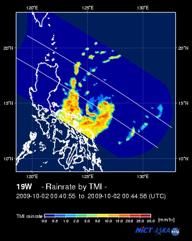
EORC-JAXA TRMM Viewer: Real-Time Rainrate Image new!
NASA-JAXA TMI Viewer: Latest Rainrate Image
Zoomed Satellite Pic: Near Real-Time
Wunderground Animation: 6-12 hr. GIF Loop
PHILIPPINE STORM SIGNAL # THREE (3)
Now In Effect: CATANDUANES.
PHILIPPINE STORM WARNING SIGNAL # TWO (2)
Now In Effect: CAMARINES PROVINCES, POLILLO, NORTHERN QUEZON, QUIRINO, AURORA, ISABELA, & CAGAYAN.
The above areas will experience stormy weather today (with winds not exceeding 100 kph for #02 and more than 100 kph for #03).
PHILIPPINE STORM WARNING SIGNAL # ONE (1)
Now In Effect: METRO MANILA, ALBAY, SORSOGON, BURIAS IS., SOUTHERN QUEZON, RIZAL, BULACAN, PAMPANGA, ZAMBALES, TARLAC, NUEVA ECIJA, PANGASINAN & REST OF NORTHERN & CENTRAL LUZON incl. BABUYAN & CALAYAN IS.
The above areas will have rains and winds of not more than 60 kph today. Coastal waters will be moderate to rough.
Residents living in low-lying and mountainous areas under Public Storm Warning Signal Numbers 1, 2 & 3 are alerted against flashfloods, mudflows, mudslides and landslides.
JTWC (US NAVY/AIR FORCE) 12, 24, 48 & 72 HR. FORECAST & REMARKS:
2 AM (18 GMT) 03 OCTOBER: 16.7N 123.1E / 215-260 KPH (TY-Cat 4) / NW @ 17 KPH
<<<Typhoon2000.
Get the latest 3-hrly SMS Storm Alerts on PEPENG!
For more details: Text T2K TYPHOON to
2800 (Globe/TM) | 216 (Smart/TNT) | 2288 (Sun)
*only P2.50 (Smart/Globe) / P2.00 (Sun) per msg received.
powered by: Synermaxx
Typhoon2000 (T2K) NEWS (Thu October 01 2009):
Currently issuing 6-hrly advisories (except 12:00 AM) on Typhoon PARMA (PEPENG).
PARMA (PEPENG) MAX WIND SPEED PER AGENCY:
+ USA (JTWC/1-min avg): 220 km/hr
+ Philippines (PAGASA/10-min avg): 195 km/hr
+ Taiwan (CWB/10-min avg): 170 km/hr
+ Beijing (NMC/2-min avg): 170 kph
+ Hong Kong (HKO/10-min avg): 165 km/hr
+ Korea (KMA/10-min avg): 160 km/hr
+ Japan (JMA/10-min avg): 150 km/hr
TYPHOON PARMA [PEPENG/19W/
T2K PUBLIC ADVISORY NUMBER 014
6:00 PM PST (10:00 GMT) Fri 02 October 2009
Source: T2K ANALYSIS / JTWC WARNING #019
View: Advisory Archives (2004-2009)
*Residents and visitors along Northern Bicol and the rest of Luzon should closely monitor the progress of PARMA.
*Kindly refer to your local warnings & bulletins issued by your country's official weather agency. This advisory is intended for additional information purposes only.
+ Forecast Outlook: PARMA is expected to continue moving NW across the warm Philippine Sea and shall make landfall over Palanan Bay in Isabela. The 3 to 5-day Long-Range Forecast shows the system slowing down as it traverses Cagayan, Abra and Ilocos Norte early Sunday morning Oct 04 and shall be off the northern coast of Ilocos Norte for the next 3 days. Please be aware that long-range forecast changes every now and then. Continued monitoring on this potential typhoon is a must for disaster preparedness agencies.
+ Effects: PARMA's circulation continues to affect Southeastern Luzon...its inner bands continues to dump moderate to heavy rains across the Bicol Region w/ winds not exceeding 55 kph overnight. Tropical Storm conditions w/ winds not exceeding 75 kph together with moderate to sometimes heavy rains can be expected along Catanduanes and parts of coastal Camarines Provinces tonight. While, the flood-stricken areas of Central and Southern Luzon including Metro Manila will be under the typhoon's outer rainbands today. 1-day rainfall accumulations of 100 up to 200 mm (moderate to heavy rain) can be expected along PARMA's rainbands...
(1) Typhoon MELOR (20W) moving very slowly and threatens the Marianas. Click here to view latest T2K advisory.
Kindly click the cool T2K Graphical Satellite Analysis, issued every afternoon, and shows various tropical systems roaming across the South China Sea and the Western Pacific Ocean.
[Important Note: Please keep in mind that the above forecast outlook, effects, current monsoon intensity, & tropical cyclone watch changes every 6 to 12 hrs!]
Time/Date: 6:00 PM PST Fri October 02 2009
Location of Eye: 15.1º N Lat 124.9º E Lon
Distance 1: 195 km (105 nm) NNE of Virac, Catanduanes
Distance 2: 195 km (105 nm) NE of Gota Beach Resort
Distance 3: 255 km (138 nm) NE of Metro Naga/CWC
Distance 4: 245 km (133 nm) ENE of Daet, Cam Norte
Distance 5: 415 km (225 nm) ENE of Metro Manila
Distance 6: 330 km (178 nm) SE of Casiguran, Aurora
MaxWinds (1-min avg): 220 kph (120 kts) near the eye
Peak Wind Gusts: 270 kph (160 kts)
Saffir-Simpson Typhoon Scale: Category 4
Coastal Storm Surge Height: 13-18 feet [4.0-5.5 m]
Minimum Central Pressure: 944 millibars (hPa)
Recent Movement: WNW @ 11 kph (06 kts)
Projected Area of Impact: Isabela-Cagayan Area
Size (in Diameter): 815 km (440 nm) / Large
Max Sea Wave Height (near center): 32 ft (9.7 m)
T2K TrackMap #05 (for Public): 12 PM PST Fri Oct 02
JTWC Ship Avoidance TrackMap: 06 GMT Fri Oct 02
Multi-Agency Forecast TrackMap: 2 PM Fri Oct 02
TSR Wind Probabilities: Current to 5-days Ahead
EORC-JAXA TRMM Viewer: Real-Time Rainrate Image new!
NASA-JAXA TMI Viewer: Latest Rainrate Image
Zoomed Satellite Pic: Near Real-Time
Wunderground Animation: 6-12 hr. GIF Loop
PHILIPPINE STORM SIGNAL # THREE (3)
Now In Effect: CATANDUANES.
PHILIPPINE STORM WARNING SIGNAL # TWO (2)
Now In Effect: CAMARINES PROVINCES, POLILLO, NORTHERN QUEZON, QUIRINO, AURORA, ISABELA, & CAGAYAN.
The above areas will experience stormy weather today (with winds not exceeding 100 kph for #02 and more than 100 kph for #03).
PHILIPPINE STORM WARNING SIGNAL # ONE (1)
Now In Effect: METRO MANILA, ALBAY, SORSOGON, BURIAS IS., SOUTHERN QUEZON, RIZAL, BULACAN, PAMPANGA, ZAMBALES, TARLAC, NUEVA ECIJA, PANGASINAN & REST OF NORTHERN & CENTRAL LUZON incl. BABUYAN & CALAYAN IS.
The above areas will have rains and winds of not more than 60 kph today. Coastal waters will be moderate to rough.
Residents living in low-lying and mountainous areas under Public Storm Warning Signal Numbers 1, 2 & 3 are alerted against flashfloods, mudflows, mudslides and landslides.
2 AM (18 GMT) 03 OCTOBER: 16.7N 123.1E / 215-260 KPH (TY-Cat 4) / NW @ 17 KPH
2 PM (06 GMT) 03 OCTOBER: 17.8N 121.7E / 205-250 KPH (TY-Cat 3) / NW @ 13 KPH
2 PM (06 GMT) 04 OCTOBER: 19.3N 120.6E / 165-205 KPH (TY-Cat 2) / NNW @ 02 KPH
2 PM (06 GMT) 05 OCTOBER: 19.8N 120.4E / 140-165 KPH (TY-Cat 1) / NW @ 02 KPH
2 PM (06 GMT) 04 OCTOBER: 19.3N 120.6E / 165-205 KPH (TY-Cat 2) / NNW @ 02 KPH
2 PM (06 GMT) 05 OCTOBER: 19.8N 120.4E / 140-165 KPH (TY-Cat 1) / NW @ 02 KPH
REMARKS: 2 PM (06 GMT) 02 OCTOBER POSITION: 15.3N 125.0E.
*TYPHOON (TY) 19W (PARMA) LOCATED APPROXIMATELY 245 NM EAST OF
MANILA, PHILIPPINES, HAS TRACKED NORTHWESTWARD AT 15 KNOTS OVER THE
PAST SIX HOURS. TY 19W CONTINUES TO TRACK ON THE SOUTHERN PERIPHERY
OF THE THE SUB-TROPICAL RIDGE TO THE NORTHEAST. THE SYSTEM IS
EXPECTED TO CONTINUE ON A WEST-NORTHWESTWARD TO NORTHWESTWARD TRACK
TOWARDS THE NORTHEASTERN COAST OF LUZON, MAKING LANDFALL NEAR TAU
12. THE SYSTEM WILL WEAKEN AS IT CROSSES NORTHERN LUZON INTO THE
LUZON STRAIT BEFORE MOVING SLOWLY INTO THE SOUTH CHINA SEA. THE
AVAILABLE NUMERICAL MODEL GUIDANCE IS IN POOR AGREEMENT, WITH
SEVERAL AIDS (NGPS, EGRR, GFDN) CROSSING NORTH-CENTRAL LUZON AND
MOVING FURTHER INTO THE SOUTH CHINA SEA. THE REMAINING AIDS (JGSM,
AVNO, WBAR AND TCLP) INDICATE A RECURVATURE SCENARIO, WITH AVNO
BEING THE MOST AGRESSIVE OF THESE (REACHING TOKYO AT TAU 120). THIS
FORECAST FAVORS THE MORE WESTWARD GROUPING, BUT REFLECTS THE
UNCERTAINTY IN THE EXTENDED PERIOD, TRACKING MUCH MORE SLOWLY IN THE
AFTER TAU 72. MAXIMUM SIGNIFICANT WAVE HEIGHT AT 020600Z IS 32 FEET...(more)
>> PARMA, meaning: Macanese food (ham with chicken livers and mushrooms). Name contributed by: Macau, China.
____________
_______________________________________________________________________________________________________________________________________
RECENT T2K TRACKING CHART:

________________________
RECENT MTSAT-1R SATELLITE IMAGE:

> Image source: NOAA SATELLITE CENTER
RECENT WUNDERGROUND SATELLITE ANIMATION: (EXPERIENCING TECHNICAL PROBLEMS)

> Image source: Wunderground.com (http://www.wunderground.com/ ) ____________________________________________________________________________________________________________________
> Image source: NOAA SATELLITE CENTER
____________________________________________________________________________________________________________________
RECENT WUNDERGROUND SATELLITE ANIMATION: (EXPERIENCING TECHNICAL PROBLEMS)
> Image source: Wunderground.
NOTE:
^ - JTWC commentary remarks (for Meteorologists) from their latest warning.
__________________________________________________________________________________________
>> To know the meteorological terminologies and acronyms used on this update visit the ff:
http://typhoon2000.ph/tcterm.htm
http://www.nhc.noaa.gov/aboutgloss.shtml
http://www.srh.noaa.gov/oun/severewx/glossary.php
http://www.srh.weather.gov/fwd/glossarynation.html
http://www.nhc.noaa.gov/acronyms.shtml
__________________________________________________________________________________________
For the complete details on TY PARMA (PEPENG)...go visit our website @:
> http://www.typhoon2000.com
> http://www.maybagyo.com
>> To know the meteorological terminologies and acronyms used on this update visit the ff:
http://typhoon2000.
http://www.nhc.
http://www.srh.
http://www.srh.
http://www.nhc.
____________
> http://www.typhoon2
> http://www.maybagyo
Copyright © 2009 Typhoon2000.
__._,_.___
MARKETPLACE
Change settings via the Web (Yahoo! ID required)
Change settings via email: Switch delivery to Daily Digest | Switch format to Traditional
Visit Your Group | Yahoo! Groups Terms of Use | Unsubscribe
.
__,_._,___

No comments:
Post a Comment