
for Thursday, 15 October 2009 [5:57 AM PST]


<<<Typhoon2000.com Mobile >>>
Get the latest SMS Storm Alerts!
For more details: Text T2K HELP to
2800 (Globe/TM) | 216 (Smart/TNT) | 2288 (Sun)
*only P2.50 (Smart/Globe) / P2.00 (Sun) per msg received.
powered by: Synermaxx
Typhoon2000 (T2K) NEWS (Thu October 15 2009):
Currently issuing 6-hrly advisories (except 12:00 AM) on the newly-formed TS 22W (UNNAMED)
22W (UNNAMED) MAX WIND SPEED PER AGENCY:
+ USA (JTWC/1-min avg): 65 km/hr
+ Japan (JMA/10-min avg): 55 km/hr
TROPICAL STORM 22W [UNNAMED]
T2K PUBLIC ADVISORY NUMBER 003
6:00 AM PST (22:00 GMT) Thu 15 October 2009
Source: T2K ANALYSIS / JTWC WARNING #004
View: Advisory Archives (2004-2009)
22W (UNNAMED) moving rapidly to the west...now a Tropical Storm...will pass south of Guam this morning.
*Residents and visitors along Eastern Luzon and the Mariana Island Chain should closely monitor the progress of 22W.
*Kindly refer to your local warnings & bulletins issued by your country's official weather agency. This advisory is intended for additional information purposes only.
+ Forecast Outlook: 22W is expected to start decelerating as it turns WNW-ward within the next 12 to 24 hours. The 2 to 5-day Long-Range Forecast shows 22W entering the Philippine Area of Responsibility (PAR) Saturday morning Oct 17 as a Category 1 Typhoon...turning more westerly slowly towards Eastern Luzon on Sunday Oct 18. It shall rapidly grow into a Category 3 Typhoon on Tuesday Oct 20 in a track that could bring it to Northern Luzon on Wednesday or Thursday. *ECMWF 10-Day Extended Long-Range Forecast: 22W shall make landfall over Northern Luzon or over Isabela Wednesday evening, Oct 21 and exit thru Ilocos Sur early Thursday morning, Oct 22. It shall be approaching Hainan Island on Saturday evening Oct 24. Please be reminded that the ECMWF model run changes every 12 hours, so a shift to the left or right of its future track and other conditions must be considered.
+ Effects: 22W's broad circulation continues to consolidate while moving rapidly westward. Its outer bands now spreading into Southern Marianas - bringing occasional rains w/ squalls and thunderstorms. 1-day rainfall accumulations of 50 up to 100 mm (moderate to heavy rain) can be expected along PARMA's rainbands...with isolated accumulations of up to 200 mm (very heavy rain) near the center of 22W particularly along its projected path. Residents in low-lying areas & steep slopes must remain alert & seek evacuation for possible life-threatening flash floods, mudslides & landslides due to the anticipated heavy rains brought about by this system. Precautionary measures must be initiated if necessary.
+ Tropical Cyclone Watch:
(1) Tropical Disturbance 93W (LPA) has moved out into the South China Sea...its rainbands spreading across Metro Manila, Mindoro, Southern Tagalog Provinces, Central Luzon and Northern Palawan including Calamian Island Group...currently located near lat 12.8N lon 118.5E...or about 205 km WNW of Coron, Palawan...with 1-min maximum sustained winds of 30 kph near the center...moving WNW @ 26 kph towards Vietnam. This system may likely become a Tropical Cyclone while over the South China Sea.
Kindly click the T2K Graphical Satellite Analysis, issued every afternoon, and shows various tropical systems roaming across the South China Sea and the Western Pacific Ocean.
[Important Note: Please keep in mind that the above forecast outlook, effects, current monsoon intensity, & tropical cyclone watch changes every 6 to 12 hrs!]
Time/Date: 6:00 AM PST Thu October 15 2009
Location of Center: 11.2º N Lat 145.4º E Lon
Distance 1: 255 km (138 nm) SSE of Guam, CNMI
Distance 2: 820 km (443 nm) ENE of Yap, FSM
Distance 3: 1,135 km (613 nm) East of P.A.R.
Distance 4: 2,160 km (1,167 nm) East of Visayas, PH
Distance 5: 2,425 km (1,310 nm) ESE of Metro Naga/CWC
MaxWinds (1-min avg): 65 kph (35 kts) near the center
Peak Wind Gusts: 85 kph (45 kts)
Saffir-Simpson Typhoon Scale: Tropical Storm
Coastal Storm Surge Height: 1-3 feet [0.3-0.9 m]
Minimum Central Pressure: 996 millibars (hPa)
Recent Movement: West @ 42 kph (23 kts)
Projected Area of Impact: Philippine Sea
Size (in Diameter): 650 km (350 nm) / Average
Max Sea Wave Height (near center): 12 ft (3.6 m)
T2K TrackMap (for Public): 6 AM PST Thu Oct 15
JTWC Ship Avoidance TrackMap: 2 AM Thu Oct 15
TSR Wind Probabilities: Current to 5-days Ahead
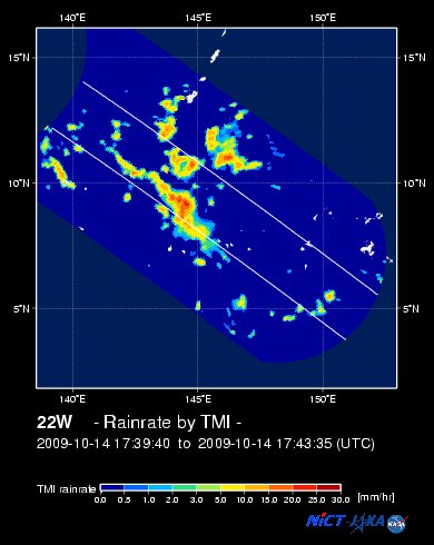
NASA-JAXA TMI Image: Latest Rainrate 01
Zoomed Satellite Pic: Near Real-Time
Wunderground Animation: 6-12 hr. GIF Loop
JTWC (US NAVY/AIR FORCE) 12, 24, 48 & 72 HR. FORECAST & REMARKS:
2 PM (06 GMT) 15 OCTOBER: 11.6N 143.3E / 75-95 KPH (TS) / WNW @ 28 KPH
<<<Typhoon2000.
Get the latest SMS Storm Alerts!
For more details: Text T2K HELP to
2800 (Globe/TM) | 216 (Smart/TNT) | 2288 (Sun)
*only P2.50 (Smart/Globe) / P2.00 (Sun) per msg received.
powered by: Synermaxx
Typhoon2000 (T2K) NEWS (Thu October 15 2009):
Currently issuing 6-hrly advisories (except 12:00 AM) on the newly-formed TS 22W (UNNAMED)
22W (UNNAMED) MAX WIND SPEED PER AGENCY:
+ USA (JTWC/1-min avg): 65 km/hr
+ Japan (JMA/10-min avg): 55 km/hr
TROPICAL STORM 22W [UNNAMED]
T2K PUBLIC ADVISORY NUMBER 003
6:00 AM PST (22:00 GMT) Thu 15 October 2009
Source: T2K ANALYSIS / JTWC WARNING #004
View: Advisory Archives (2004-2009)
*Residents and visitors along Eastern Luzon and the Mariana Island Chain should closely monitor the progress of 22W.
*Kindly refer to your local warnings & bulletins issued by your country's official weather agency. This advisory is intended for additional information purposes only.
+ Forecast Outlook: 22W is expected to start decelerating as it turns WNW-ward within the next 12 to 24 hours. The 2 to 5-day Long-Range Forecast shows 22W entering the Philippine Area of Responsibility (PAR) Saturday morning Oct 17 as a Category 1 Typhoon...turning more westerly slowly towards Eastern Luzon on Sunday Oct 18. It shall rapidly grow into a Category 3 Typhoon on Tuesday Oct 20 in a track that could bring it to Northern Luzon on Wednesday or Thursday. *ECMWF 10-Day Extended Long-Range Forecast: 22W shall make landfall over Northern Luzon or over Isabela Wednesday evening, Oct 21 and exit thru Ilocos Sur early Thursday morning, Oct 22. It shall be approaching Hainan Island on Saturday evening Oct 24. Please be reminded that the ECMWF model run changes every 12 hours, so a shift to the left or right of its future track and other conditions must be considered.
+ Effects: 22W's broad circulation continues to consolidate while moving rapidly westward. Its outer bands now spreading into Southern Marianas - bringing occasional rains w/ squalls and thunderstorms. 1-day rainfall accumulations of 50 up to 100 mm (moderate to heavy rain) can be expected along PARMA's rainbands...
(1) Tropical Disturbance 93W (LPA) has moved out into the South China Sea...its rainbands spreading across Metro Manila, Mindoro, Southern Tagalog Provinces, Central Luzon and Northern Palawan including Calamian Island Group...currently located near lat 12.8N lon 118.5E...or about 205 km WNW of Coron, Palawan...with 1-min maximum sustained winds of 30 kph near the center...moving WNW @ 26 kph towards Vietnam. This system may likely become a Tropical Cyclone while over the South China Sea.
Kindly click the T2K Graphical Satellite Analysis, issued every afternoon, and shows various tropical systems roaming across the South China Sea and the Western Pacific Ocean.
[Important Note: Please keep in mind that the above forecast outlook, effects, current monsoon intensity, & tropical cyclone watch changes every 6 to 12 hrs!]
Time/Date: 6:00 AM PST Thu October 15 2009
Location of Center: 11.2º N Lat 145.4º E Lon
Distance 1: 255 km (138 nm) SSE of Guam, CNMI
Distance 2: 820 km (443 nm) ENE of Yap, FSM
Distance 3: 1,135 km (613 nm) East of P.A.R.
Distance 4: 2,160 km (1,167 nm) East of Visayas, PH
Distance 5: 2,425 km (1,310 nm) ESE of Metro Naga/CWC
MaxWinds (1-min avg): 65 kph (35 kts) near the center
Peak Wind Gusts: 85 kph (45 kts)
Saffir-Simpson Typhoon Scale: Tropical Storm
Coastal Storm Surge Height: 1-3 feet [0.3-0.9 m]
Minimum Central Pressure: 996 millibars (hPa)
Recent Movement: West @ 42 kph (23 kts)
Projected Area of Impact: Philippine Sea
Size (in Diameter): 650 km (350 nm) / Average
Max Sea Wave Height (near center): 12 ft (3.6 m)
T2K TrackMap (for Public): 6 AM PST Thu Oct 15
JTWC Ship Avoidance TrackMap: 2 AM Thu Oct 15
TSR Wind Probabilities: Current to 5-days Ahead
NASA-JAXA TMI Image: Latest Rainrate 01
Zoomed Satellite Pic: Near Real-Time
Wunderground Animation: 6-12 hr. GIF Loop
2 PM (06 GMT) 15 OCTOBER: 11.6N 143.3E / 75-95 KPH (TS) / WNW @ 28 KPH
2 AM (18 GMT) 16 OCTOBER: 12.4N 140.3E / 95-120 KPH (TS) / WNW @ 22 KPH
2 AM (18 GMT) 17 OCTOBER: 14.1N 135.4E / 120-150 KPH (TY-Cat 1) / WNW @ 15 KPH
2 AM (18 GMT) 18 OCTOBER: 15.4N 132.5E / 150-185 KPH (TY-Cat 1) / W @ 11 KPH
2 AM (18 GMT) 17 OCTOBER: 14.1N 135.4E / 120-150 KPH (TY-Cat 1) / WNW @ 15 KPH
2 AM (18 GMT) 18 OCTOBER: 15.4N 132.5E / 150-185 KPH (TY-Cat 1) / W @ 11 KPH
REMARKS: 2 AM (18 GMT) THU 15 OCTOBER POSITION: 11.0N 146.5E.
*TS 22W HAS MAINTAINED A BROAD CIRCULATION WITH
BROKEN BANDS OF CONVECTION WRAPPING TOWARD THE LOW LEVEL CIRCULATION
CENTER (LLCC). THE DEEPEST CONVECTION HAS PERSISTED ON THE WESTERN
HALF OF THE SYSTEM. RECENTLY, CONVECTION HAS EXPANDED AND DEEPENED
AROUND TS 22W, AND HAS CONSOLIDATED INTO COMPACT CELLS OF DEEP
CONVECTION WITHIN THE BANDS. A 141146Z ASCAT PASS INDICATES THAT THE
LLCC HAS BECOME BETTER ORGANIZED THAN A PREVIOUS 140755Z PASS SHOWED.
DVORAK SATELLITE POSITION FIXES FROM PGTW REFLECTED A SLIGHT
STRENGTHENING TREND OVER THE PAST 06 HOURS, WITH THE ANIMATED WATER
VAPOR IMAGERY SHOWING THE DEEPEST CONVECTION CONTINUING TO BUILD ON
THE WESTERN PERIPHERY OF THE SYSTEM. A RECENT 141741Z TRMM 37H PASS
SHOWS A DEVELOPING LLCC WITH TIGHTLY CURVED BANDING PRESENT, HELPING
TO SUPPORT THE CURRENT INTENSITY OF 35 KNOTS. TS 22W IS FORECAST TO
TRACK GENERALLY WEST-NORTHWESTWARD UNDER THE STEERING INFLUENCE OF
THE LOW- TO MID-LEVEL SUBTROPICAL RIDGE (STR) POSITIONED NORTHEAST
OF THE SYSTEM. MODEL GUIDANCE HAS IMPROVED OVER THE PAST 12 HOURS,
WITH GOOD AGREEMENT FOR THE CURRENT FORECAST. HOWEVER, CURRENT
GUIDANCE INDICATES A SLOWER THAN PREVIOUSLY FORECASTED TRACK SPEED
IN THE EXTENDED TAUS. INTENSITY IS CURRENTLY EXPECTED TO INCREASE
GRADUALLY OVER THE NEXT 48 HOURS BUT AS IT MOVES OVER A REGION OF
HIGH OCEAN HEAT CONTENT AND INCREASED UPPER LEVEL OUTFLOW, BETWEEN
TAU 48 AND 72, THE INTENSITY WILL RISE FASTER. TYPHOON STRENGTH IS
EXPECTED AROUND TAU 48. IN THE EXTENDED RANGE, TS 22W IS FORECAST TO
CONTINUE TRACKING WEST-NORTHWESTWARD AND SHOULD INTENSIFY THROUGHOUT
THE FORECAST PERIOD...(more)
____________
_______________________________________________________________________________________________________________________________________
RECENT TYPHOON2000.

________________________
RECENT MTSAT-1R SATELLITE IMAGE:

> Image source: NOAA SATELLITE CENTER
RECENT WUNDERGROUND SATELLITE ANIMATION:

> Image source: Wunderground.com (http://www.wunderground.com/ ) ____________________________________________________________________________________________________________________
> Image source: NOAA SATELLITE CENTER
____________________________________________________________________________________________________________________
RECENT WUNDERGROUND SATELLITE ANIMATION:
> Image source: Wunderground.
NOTE:
^ - JTWC commentary remarks (for Meteorologists) from their latest warning.
__________________________________________________________________________________________
>> To know the meteorological terminologies and acronyms used on this update visit the ff:
http://typhoon2000.ph/tcterm.htm
http://www.nhc.noaa.gov/aboutgloss.shtml
http://www.srh.noaa.gov/oun/severewx/glossary.php
http://www.srh.weather.gov/fwd/glossarynation.html
http://www.nhc.noaa.gov/acronyms.shtml
__________________________________________________________________________________________
For the complete details on TS 22W (UNNAMED)...go visit our website @:
> http://www.typhoon2000.com
> http://www.maybagyo.com
>> To know the meteorological terminologies and acronyms used on this update visit the ff:
http://typhoon2000.
http://www.nhc.
http://www.srh.
http://www.srh.
http://www.nhc.
____________
>
> http://www.maybagyo
Copyright © 2009 Typhoon2000.
__._,_.___
Change settings via the Web (Yahoo! ID required)
Change settings via email: Switch delivery to Daily Digest | Switch format to Traditional
Visit Your Group | Yahoo! Groups Terms of Use | Unsubscribe
.
__,_._,___

No comments:
Post a Comment