

<<<Typhoon2000.
Get the latest 6-hrly SMS Storm Alerts on RAMIL!
For more details: Text T2K TYPHOON to
2800 (Globe/TM) | 216 (Smart/TNT) | 2288 (Sun)
*only P2.50 (Smart/Globe) / P2.00 (Sun) per msg received.
powered by: Synermaxx
Typhoon2000 (T2K) NEWS (Tue October 20 2009):
Currently issuing 6-hrly advisories (except 12:00 AM) on TY LUPIT (RAMIL)
LUPIT (RAMIL) MAX WIND SPEED PER AGENCY:
+ Philippines (PAGASA/10-min avg): 175 km/hr
+ USA (JTWC/1-min avg): 160 km/hr
+ Beijing (NMC/2-min avg): 160 kph
+ Taiwan (CWB/10-min avg): 160 km/hr
+ Korea (KMA/10-min avg): 145 km/hr
+ Japan (JMA/10-min avg): 140 km/hr
TYPHOON LUPIT [RAMIL/22W/0920]
T2K PUBLIC ADVISORY NUMBER 021
6:00 AM PST (22:00 GMT) Wed 21 October 2009
Source: T2K ANALYSIS / JTWC WARNING #028
View: Advisory Archives (2004-2009)
*Residents and visitors along Northern Luzon & Taiwan should closely monitor the progress of LUPIT (RAMIL).
*Kindly refer to your local warnings & bulletins issued by your country's official weather agency. This advisory is intended for additional information purposes only.
+ Forecast Outlook: LUPIT's forecast track has changed significantly with a much slower pace. The typhoon is now expected to decelerate as it tracks more WSW w/in the next 12 to 24 hours. Its wind speed will slightly strengthen back to Category 3 (185 kph) as it moves closer to Northern Luzon due to improved atmospheric conditions (warm ocean moisture & unstable air). The 2 to 5-day Long-Range Forecast shows LUPIT decelerating more as it approaches the northern coast of Cagayan on a WSW direction. LUPIT shall make landfall over the coast of Northern Ilocos Norte, near or over the town of Pagudpod early Sunday morning Oct 25 or approx. 2-3AM, & shall pass just to the north of Laoag City approx. 8-9 AM (Sun Oct 25). By early Monday morning, Oct 26, LUPIT shall be moving slowly across the South China Sea. *Alternate Forecast Scenario: There is a possibility that LUPIT might track Westward passing thru the Balintang Channel and spare Cagayan & Ilocos Norte from a direct hit, then move NW to Northward into Taiwan or SE China. This scenario is likely as some models deviates from the abovementioned forecast. The probability of this alternate forecast has increased, so a possible shift can happen. Please be reminded that the Forecast Outlook changes every 6 hours, so a turn to the left or right of its future track and other conditions must be considered.
+ Effects: LUPIT's Eyewall Replacement Cycle has ended, now shows a large eyewall, with still a cloud-filled EYE...its over-all circulation has slightly improved. Its outer & inner rain bands remains at sea...not yet affecting any major islands at this time. LUPIT may begin to affect Extreme Northern Luzon beginning tonight or tomorrow - if the forecast movement continues...
Time/Date: 6:00 AM PST Wed October 21 2009
Location of Eye: 20.3º N Lat 127.4º E Lon
Distance 1: 565 km (305 nm) East of Basco, Batanes
Distance 2: 645 km (350 nm) ENE of Aparri, Cagayan
Distance 3: 670 km (362 nm) NE of Tuguegarao City
Distance 4: 685 km (370 nm) NE of Ilagan City
Distance 5: 720 km (390 nm) NE of Casiguran, Aurora
Distance 6: 750 km (405 nm) ENE of Laoag City
Distance 7: 870 km (470 nm) NNE of Naga City
Distance 8: 920 km (497 nm) NE of Metro Manila
MaxWinds (1-min avg): 160 kph (85 kts) near the Eye
Peak Wind Gusts: 195 kph (105 kts)
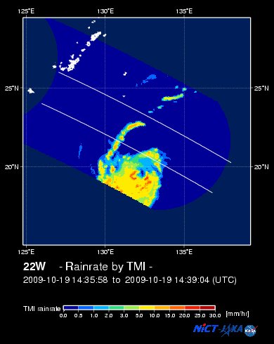
Rainbands' Rain Rate: 2 to 30 mm/hr (.02 to 1.2 in/hr) new!
Saffir-Simpson Typhoon Scale: Category 2
Coastal Storm Surge Height: 6-8 feet [1.8-2.6 m]
Minimum Central Pressure: 959 millibars (hPa)
Recent Movement: WSW @ 15 kph (08 kts)
Projected Area of Impact: Extreme Northern Luzon
Size (in Diameter): 925 km (500 nm) / Very Large
Max Sea Wave Height (near center): 33 ft (10.0 m)
JTWC Ship Avoidance TrackMap: 2 AM Wed Oct 21
Multi-Agency Forecast TrackMap: 2 AM Wed Oct 21
TSR Wind Probabilities: Current to 5-days Ahead
NASA-JAXA TMI Image: Latest Rainrate 01
EORC-JAXA TRMM Image: Latest Rainrate 02
Zoomed Satellite Pic: Near Real-Time
Wunderground Animation: 6-12 hr. GIF Loop
PHILIPPINE STORM WARNING SIGNAL # TWO (2) 
In Effect: BATANES ISLAND GROUP, CAGAYAN, CALAYAN & BABUYAN ISLANDS, APAYAO, KALINGA & ISABELA.
The above areas will experience stormy weather beginning tomorrow (with winds not exceeding 100 kph). Coastal waters will be rough to very rough and extremely dangerous to all types of seacrafts.
PHILIPPINE STORM WARNING SIGNAL # ONE (1)
Now In Effect: ILOCOS NORTE, ILOCOS SUR, ABRA, MOUNTAIN PROVINCE, BENGUET, LA UNION, IFUGAO, NUEVA VIZCAYA, QUIRINO, AURORA, NORTHERN AURORA, & POLILLO ISLAND.
The above areas will have rains and winds of not more than 60 kph beginning tonight or tomorrow. Coastal waters will be moderate to rough.
Residents living in low-lying and mountainous areas under Public Storm Warning Signal Numbes 2 & 1 are alerted against flashfloods, mudflows, mudslides and landslides..
2 PM (06 GMT) 21 OCTOBER: 20.2N 126.4E / 175-215 KPH (TY-Cat 2) / WSW @ 13 KPH
2 AM (18 GMT) 23 OCTOBER: 19.0N 122.9E / 175-215 KPH (TY-Cat 2) / WSW @ 04 KPH
2 AM (18 GMT) 24 OCTOBER: 18.8N 122.0E / 160-195 KPH (TY-Cat 2) / W @ 04 KPH
REMARKS: 2 AM (18 GMT) WED 21 OCTOBER POSITION: 20.5N 127.9E.
*THE CURRENT POSITION AND INTENSITY ESTIMATES ARE
CONSISTENT WITH RECENT DVORAK SATELLITE FIXES FROM PGTW AND RJTD. TY
22W IS TRACKING WESTWARD UNDER THE STEERING INFLUENCE OF A
SUBTROPICAL RIDGE EXTENSION TO THE NORTH. DEEP CONVECTION HAS BECOME
MORE ORGANIZED NEAR THE STORM CENTER OVER THE PAST SIX HOURS, AND A
201709Z AMSU-B PASS INDICATES THAT A NEW LARGE EYEWALL HAS DEVELOPED
FOLLOWING A RECENT EYEWALL REPLACEMENT CYCLE. THE TRACK FORECAST FOR
TY 22W HAS BECOME MORE UNCERTAIN SINCE THE PREVIOUS FORECAST DUE TO
A SPLIT IN THE NUMERICAL MODEL GUIDANCE. ONE SET OF MODEL SOLUTIONS,
INCLUDING THE JGSM, NOGAPS, GFDN, AND GFS, DEPICTS A SLOWDOWN AND
POLEWARD RECURVATURE UNDER THE INFLUENCE OF A STRENGTHENING
PERIPHERAL ANTICYCLONE TO THE SOUTHEAST OF THE STORM DURING THE NEXT
72 HOURS. THREE OF THESE MODEL SOLUTIONS, JGSM, NOGAPS, AND GFDN,
HAVE ABRUPTLY SHIFTED FROM THE PREVIOUS RUN. A SECOND SET OF
SOLUTIONS, INCLUDING THE ECMWF AND THE UKMET MODEL, SHOW THE TYPHOON
CONTINUING WESTWARD AS A NEW SUBTROPICAL STEERING RIDGE BUILDS IN
FROM THE NORTHWEST. THIS SECOND SET OF SOLUTIONS IS CONSISTENT WITH
PREVIOUS MODEL GUIDANCE AND JTWC FORECASTS AND IS SUPPORTED BY
ANALYSIS OF A PERSISTENT SUBTROPICAL RIDGE TO THE WEST-NORTHWEST OF
TY 22W AND A ZONAL MIDLATITUDE FLOW PATTERN TO THE NORTH. THUS, THE
CURRENT FORECAST TRACK FAVORS THESE WESTWARD-RUNNING MODEL
SOLUTIONS. HOWEVER, A SIGNIFICANT SHIFT IN THE FORECAST MAY BE
NECESSARY IF MODEL GUIDANCE AND SYNOPTIC FEATURES CONTINUE TO SHIFT
IN FAVOR OF THE SLOWER MOTION SCENARIO. LOW VERTICAL WIND SHEAR AND
FAVORABLE OCEAN HEAT CONTENT ARE EXPECTED TO SUPPORT INTENSIFICATION
DURING THE FORECAST PERIOD UNTIL THE SYSTEM MAKES LANDFALL OVER
NORTHERN LUZON...(more)
>> LUPIT, meaning: Cruel; viciousness. Name contributed by: Philippines.
____________
PAGASA CURRENT POSITION, MOVEMENT AND INTENSITY (10-min. ave.):
:: For the complete PAGASA bulletin, kindly visit their website at:
http://www.pagasa.
____________
RECENT TYPHOON2000.

________________________

> Image source: NOAA SATELLITE CENTER
RECENT WUNDERGROUND SATELLITE ANIMATION:
> Image source: Wunderground.
>> To know the meteorological terminologies and acronyms used on this update visit the ff:
http://typhoon2000.
http://www.nhc.
http://www.srh.
http://www.srh.
http://www.nhc.
____________
> http://www.typhoon2
> http://www.maybagyo
Copyright © 2009 Typhoon2000.
Change settings via the Web (Yahoo! ID required)
Change settings via email: Switch delivery to Daily Digest | Switch format to Traditional
Visit Your Group | Yahoo! Groups Terms of Use | Unsubscribe

No comments:
Post a Comment