
for Wednesday, 14 October 2009 [5:42 AM PST]


<<<Typhoon2000.com Mobile >>>
Get the latest SMS Storm Alerts!
For more details: Text T2K HELP to
2800 (Globe/TM) | 216 (Smart/TNT) | 2288 (Sun)
*only P2.50 (Smart/Globe) / P2.00 (Sun) per msg received.
powered by: Synermaxx
Typhoon2000 (T2K) NEWS (Tue October 13 2009):
Currently issuing 6-hrly web advisories (except 12:00 AM) on TS PARMA (PEPENG)
PARMA (PEPENG) MAX WIND SPEED PER AGENCY:
+ Hong Kong (HKO/10-min avg): 105 km/hr
+ Beijing (NMC/2-min avg): 100 kph
+ USA (JTWC/1-min avg): 100 km/hr
+ Japan (JMA/10-min avg): 75 km/hr
+ Korea (KMA/10-min avg): 75 km/hr
+ Taiwan (CWB/10-min avg): 65 km/hr
TROPICAL STORM PARMA [PEPENG/19W/0917]
T2K PUBLIC ADVISORY NUMBER 043
6:00 AM PST (22:00 GMT) Wed 14 October 2009
Source: T2K ANALYSIS / JTWC WARNING #065
View: Advisory Archives (2004-2009)
PARMA (PEPENG) starting to weaken as it approaches the shorelines of Northern Vietnam...downgraded to Tropical Storm.
*Residents and visitors along Northern Vietnam should closely monitor the progress of PARMA.
*Kindly refer to your local warnings & bulletins issued by your country's official weather agency. This advisory is intended for additional information purposes only.
+ Forecast Outlook: PARMA is expected to make landfall ESE of Hanoi this afternoon or noontime. It will dissipate rapidly later tonight as it tracks overland across Northern Vietnam.
+ Effects: PARMA's main core is off the coast of Northern Vietnam. Its Eyewall has weaken but still affecting the coast...with the EYE deteriorating some 50 km. away from the shoreline of Northern Vietnam...Tropical Storm conditions (winds of not more than 100 kph) can be expected throughout the day. 1-day rainfall accumulations of 100 up to 200 mm (moderate to heavy rain) can be expected along PARMA's rainbands...with isolated accumulations of up to 300 mm (heavy to extreme rain) near the center of PARMA or along mountains slopes particularly along its path. Residents in low-lying areas & steep slopes must remain alert & seek evacuation for possible life-threatening flash floods, mudslides & landslides due to the anticipated heavy rains brought about by this system. Precautionary measures must be initiated if necessary.
+ Tropical Cyclone Watch:
(1) Tropical Disturbance 93W (LPA) is now along the SE coast of Samar Island...w/ its rainbands ahead of its center, covering the whole of the Visayas & Bicol Region...currently located near lat 10.8N lon 126.0E...or about 120 km ESE of Tacloban City, Leyte...with 1-min maximum sustained winds of 30 kph near the center...moving WNW @ 22 kph Leyte & Northern Visayas. This system may likely become a Tropical Cyclone once it reaches the South China Sea tomorrow or Friday.
(2) Tropical Disturbance 94W [LPA], a new one has been observed forming west of Marshall Islands and is moving West to WNW in the direction of the Marianas. This system may likely become a Tropical Cyclone w/in the next 24-48 hours...currently located near lat 10.0N lon 153.0E...or about 970 km ESE of Guam...1,970 km East of P.A.R...2,995 km East of Visayas. It has 1-min. windspeeds of 40 kph near the center. The latest (12Z Oct 13) European Forecast Guidance Model (ECMWF, European Centre for Medium-Range Weather Forecasts), which is the better and most-reliable guidance model this 2009 - shows this system heading westerly into the Philippine Sea, this weekend, becoming a dangerous typhoon as it approaches Luzon, Philippines on Wednesday, October 21 and striking Isabela-Northern Luzon Area on Thursday to Friday (October 22 to 23). Please take note that this model changes every 12 hours, so a shift to the left or right of its future track and other conditions must be considered.
Kindly click the T2K Graphical Satellite Analysis, issued every afternoon, and shows various tropical systems roaming across the South China Sea and the Western Pacific Ocean.
[Important Note: Please keep in mind that the above forecast outlook, effects, current monsoon intensity, & tropical cyclone watch changes every 6 to 12 hrs!]
Time/Date: 6:00 AM PST Wed October 14 2009
Location of Center: 20.5º N Lat 107.3º E Lon
Distance 1: 55 km (30 nm) East of N.Vietnam's Shoreline
Distance 2: 165 km (90 nm) ESE of Hanoi, Vietnam
MaxWinds (1-min avg): 100 kph (55 kts) near the center
Peak Wind Gusts: 130 kph (70 kts)
Saffir-Simpson Typhoon Scale: Tropical Storm
Coastal Storm Surge Height: 1-3 feet [0.3-0.9 m]
Minimum Central Pressure: 982 millibars (hPa)
Recent Movement: WNW @ 05 kph (03 kts)
Projected Area of Impact: Northern Vietnam
Size (in Diameter): 445 km (240 nm) / Average
Max Sea Wave Height (near center): 11 ft (3.3 m)
Wunder TrackMap (for Public): 2 AM PST Wed Oct 14
JTWC Ship Avoidance TrackMap: 2 AM Wed Oct 14
Multi-Agency Forecast TrackMap: 2 AM Wed Oct 14
TSR Wind Probabilities: Current to 1-day Ahead
EORC-JAXA TRMM Image: Latest Rainrate 01
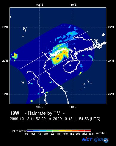
NASA-JAXA TMI Image: Latest Rainrate 02
Zoomed Satellite Pic: Near Real-Time
Wunderground Animation: 6-12 hr. GIF Loop
JTWC (US NAVY/AIR FORCE) 12, 24, & 36 HR. FORECAST & REMARKS:
2 PM (06 GMT) 14 OCTOBER: 20.6N 106.8E / 95-120 KPH (TS) / WNW @ 05 KPH
<<<Typhoon2000.
Get the latest SMS Storm Alerts!
For more details: Text T2K HELP to
2800 (Globe/TM) | 216 (Smart/TNT) | 2288 (Sun)
*only P2.50 (Smart/Globe) / P2.00 (Sun) per msg received.
powered by: Synermaxx
Typhoon2000 (T2K) NEWS (Tue October 13 2009):
Currently issuing 6-hrly web advisories (except 12:00 AM) on TS PARMA (PEPENG)
PARMA (PEPENG) MAX WIND SPEED PER AGENCY:
+ Hong Kong (HKO/10-min avg): 105 km/hr
+ Beijing (NMC/2-min avg): 100 kph
+ USA (JTWC/1-min avg): 100 km/hr
+ Japan (JMA/10-min avg): 75 km/hr
+ Korea (KMA/10-min avg): 75 km/hr
+ Taiwan (CWB/10-min avg): 65 km/hr
TROPICAL STORM PARMA [PEPENG/19W/
T2K PUBLIC ADVISORY NUMBER 043
6:00 AM PST (22:00 GMT) Wed 14 October 2009
Source: T2K ANALYSIS / JTWC WARNING #065
View: Advisory Archives (2004-2009)
*Residents and visitors along Northern Vietnam should closely monitor the progress of PARMA.
*Kindly refer to your local warnings & bulletins issued by your country's official weather agency. This advisory is intended for additional information purposes only.
+ Forecast Outlook: PARMA is expected to make landfall ESE of Hanoi this afternoon or noontime. It will dissipate rapidly later tonight as it tracks overland across Northern Vietnam.
+ Effects: PARMA's main core is off the coast of Northern Vietnam. Its Eyewall has weaken but still affecting the coast...with the EYE deteriorating some 50 km. away from the shoreline of Northern Vietnam...Tropical Storm conditions (winds of not more than 100 kph) can be expected throughout the day. 1-day rainfall accumulations of 100 up to 200 mm (moderate to heavy rain) can be expected along PARMA's rainbands...
(1) Tropical Disturbance 93W (LPA) is now along the SE coast of Samar Island...w/ its rainbands ahead of its center, covering the whole of the Visayas & Bicol Region...currently located near lat 10.8N lon 126.0E...or about 120 km ESE of Tacloban City, Leyte...with 1-min maximum sustained winds of 30 kph near the center...moving WNW @ 22 kph Leyte & Northern Visayas. This system may likely become a Tropical Cyclone once it reaches the South China Sea tomorrow or Friday.
(2) Tropical Disturbance 94W [LPA], a new one has been observed forming west of Marshall Islands and is moving West to WNW in the direction of the Marianas. This system may likely become a Tropical Cyclone w/in the next 24-48 hours...currently located near lat 10.0N lon 153.0E...or about 970 km ESE of Guam...1,970 km East of P.A.R...2,995 km East of Visayas. It has 1-min. windspeeds of 40 kph near the center. The latest (12Z Oct 13) European Forecast Guidance Model (ECMWF, European Centre for Medium-Range Weather Forecasts), which is the better and most-reliable guidance model this 2009 - shows this system heading westerly into the Philippine Sea, this weekend, becoming a dangerous typhoon as it approaches Luzon, Philippines on Wednesday, October 21 and striking Isabela-Northern Luzon Area on Thursday to Friday (October 22 to 23). Please take note that this model changes every 12 hours, so a shift to the left or right of its future track and other conditions must be considered.
Kindly click the T2K Graphical Satellite Analysis, issued every afternoon, and shows various tropical systems roaming across the South China Sea and the Western Pacific Ocean.
[Important Note: Please keep in mind that the above forecast outlook, effects, current monsoon intensity, & tropical cyclone watch changes every 6 to 12 hrs!]
Time/Date: 6:00 AM PST Wed October 14 2009
Location of Center: 20.5º N Lat 107.3º E Lon
Distance 1: 55 km (30 nm) East of N.Vietnam's Shoreline
Distance 2: 165 km (90 nm) ESE of Hanoi, Vietnam
MaxWinds (1-min avg): 100 kph (55 kts) near the center
Peak Wind Gusts: 130 kph (70 kts)
Saffir-Simpson Typhoon Scale: Tropical Storm
Coastal Storm Surge Height: 1-3 feet [0.3-0.9 m]
Minimum Central Pressure: 982 millibars (hPa)
Recent Movement: WNW @ 05 kph (03 kts)
Projected Area of Impact: Northern Vietnam
Size (in Diameter): 445 km (240 nm) / Average
Max Sea Wave Height (near center): 11 ft (3.3 m)
Wunder TrackMap (for Public): 2 AM PST Wed Oct 14
JTWC Ship Avoidance TrackMap: 2 AM Wed Oct 14
Multi-Agency Forecast TrackMap: 2 AM Wed Oct 14
TSR Wind Probabilities: Current to 1-day Ahead
EORC-JAXA TRMM Image: Latest Rainrate 01
NASA-JAXA TMI Image: Latest Rainrate 02
Zoomed Satellite Pic: Near Real-Time
Wunderground Animation: 6-12 hr. GIF Loop
2 PM (06 GMT) 14 OCTOBER: 20.6N 106.8E / 95-120 KPH (TS) / WNW @ 05 KPH
2 AM (18 GMT) 15 OCTOBER: 20.8N 106.2E / 55-75 KPH (TD) / W @ 05 KPH
2 PM (06 GMT) 15 OCTOBER: 20.9N 105.5E / 35-55 KPH (LPA) / --- @ -- KPH
2 PM (06 GMT) 15 OCTOBER: 20.9N 105.5E / 35-55 KPH (LPA) / --- @ -- KPH
REMARKS: 2 AM (18 GMT) WED 14 OCTOBER POSITION: 20.4N 107.4E.
*PARMA HAS CONTINUED TO SLOWLY DRIFT
TO THE WEST-NORTHWEST UNDER THE INFLUENCE OF THE LOW- TO MID-LEVEL
SUBTROPICAL RIDGE (STR) LOCATED TO THE NORTH OF PARMA. ALTHOUGH
SOME CONVECTION ON THE WESTERN PERIPHERY HAS BEGUN TO WEAKEN
SLIGHTLY DUE TO LAND INTERACTION, CONVECTION REMAINS DEEPEST IN A
SINGLE BAND, WRAPPING AROUND THE EASTERN SIDE OF THE LOW LEVEL
CIRCULATION CENTER (LLCC). A 131153Z TRMM MICROWAVE IMAGE STRONGLY
SUGGESTS AN EYE FEATURE WITH DEEP CONVECTION ALMOST SURROUNDING THE
LLCC. THE CENTER HAS REMAINED FREE OF CONVECTION OVER THE PAST 12
HOURS. AFTER THE SYSTEM EMERGED FROM HAINAN ISLAND IT REDEVELOPED
VERY QUICKLY AND SATELLITE INTENSITY ESTIMATES AND MODEL GUIDANCE
WERE SLOW TO REFLECT THIS CHANGE. INTENSITY HAS BEEN INCREASED TO
REFLECT THE ACTUAL STRENGTH OF THE SYSTEM. THE INCREASE DOES NOT
REFLECT A RAPID INTENSIFICATION IN THE LAST 6 HOURS, BUT A
CORRECTION TO AN INCREASE OVER THE LAST 24 HOURS. CURRENT INTENSITY
IS BASED ON DVORAK ESTIMATES OF 55 KNOTS FROM PGTW AND KNES. TS 19W
WILL CONTINUE TO TRACK WEST-NORTHWESTWARD UNDER THE INFLUENCE OF
THE STR, UNTIL IT MAKES LANDFALL IN VIETNAM. AS TS 19W TRACKS
INLAND, THE TRACK WILL FLATTEN IN A MORE WESTWARD DIRECTION, AND
THE SYSTEM IS EXPECTED TO DISSIPATE QUICKLY OVER VIETNAM...(more)
>> PARMA, meaning: Macanese food (ham with chicken livers and mushrooms). Name contributed by: Macau, China.
____________
_______________________________________________________________________________________________________________________________________
RECENT WUNDERGROUND.
________________________
RECENT MTSAT-1R SATELLITE IMAGE:

> Image source: NOAA SATELLITE CENTER
RECENT WUNDERGROUND SATELLITE ANIMATION: (EXPERIENCING TECHNICAL PROBLEMS)

> Image source: Wunderground.com (http://www.wunderground.com/ ) ____________________________________________________________________________________________________________________
> Image source: NOAA SATELLITE CENTER
____________________________________________________________________________________________________________________
RECENT WUNDERGROUND SATELLITE ANIMATION: (EXPERIENCING TECHNICAL PROBLEMS)
> Image source: Wunderground.
NOTE:
^ - JTWC commentary remarks (for Meteorologists) from their latest warning.
__________________________________________________________________________________________
>> To know the meteorological terminologies and acronyms used on this update visit the ff:
http://typhoon2000.ph/tcterm.htm
http://www.nhc.noaa.gov/aboutgloss.shtml
http://www.srh.noaa.gov/oun/severewx/glossary.php
http://www.srh.weather.gov/fwd/glossarynation.html
http://www.nhc.noaa.gov/acronyms.shtml
__________________________________________________________________________________________
For the complete details on TS PARMA (PEPENG)...go visit our website @:
> http://www.typhoon2000.com
> http://www.maybagyo.com
>> To know the meteorological terminologies and acronyms used on this update visit the ff:
http://typhoon2000.
http://www.nhc.
http://www.srh.
http://www.srh.
http://www.nhc.
____________
> http://www.typhoon2
> http://www.maybagyo
Copyright © 2009 Typhoon2000.
__._,_.___
MARKETPLACE
Change settings via the Web (Yahoo! ID required)
Change settings via email: Switch delivery to Daily Digest | Switch format to Traditional
Visit Your Group | Yahoo! Groups Terms of Use | Unsubscribe
.
__,_._,___

No comments:
Post a Comment