
for Friday, 14 October 2011 [7:00 AM PhT]
![]()

<<<Typhoon2000.com Mobile >>>
Get the latest 6-hrly SMS Storm Alerts on RAMON!
For more details: Text T2K TYPHOON to
2800 (Globe/TM) | 216 (Smart/TNT) | 2288 (Sun)
*Only P2.50 (Smart/Globe) / P2.00 (Sun) per msg received.
Click here on how to use this service (in PDF file)
Powered by: Synermaxx Corporation
Typhoon2000 (T2K) NEWS (Tuesday Oct 11 2011):
Currently issuing 6-hrly web, SMS, email, & iTyphoon app updates (except 12:00 Midnight) on BANYAN (RAMON).
BANYAN (RAMON) MAX WIND SPEED PER AGENCY:
+ USA (JTWC/1-min avg): 55 km/hr
+ Japan (JMA/10-min avg): 55 km/hr
+ Philippines (PAGASA/10-min avg): 55 km/hr
+ Beijing (NMC/2-min avg): 55 km/hr
+ Taiwan (CWB/10-min avg): -- km/hr
+ Korea (KMA/10-min avg): -- km/hr
+ Hong Kong (HKO/10-min avg): 45 km/hr
:: Click here to see Multi-Agency Forecast Tracks
TROPICAL DEPRESSION BANYAN [RAMON/23W/1120]
T2K PUBLIC ADVISORY NUMBER 013
6:00 AM PhT (22:00 GMT) Fri 14 October 2011
Source: T2K Analysis/JTWC TC Warning #016/SatFixes
View: Advisory Archives (2004-2011)
Tropical Depression BANYAN (RAMON) continues to move northwest farther away from the Philippines...expected to exit the Philippine Area of Responsibility (PAR) today. Eastern outermost rainbands still affecting the western portions of Luzon.
Residents and visitors along Hainan & Vietnam should closely monitor the progress of BANYAN (RAMON).
Do not use this for life or death decision. This advisory is intended for additional information purposes only. Kindly refer to your country's official weather agency for local warnings, advisories & bulletins.
CURRENT STORM INFORMATION
Time/Date: 6:00 AM PhT Fri October 14 2011
Location of Center: 16.4º N Lat 116.6º E Lon
Distance 1: 395 km West of San Fernando City
Distance 2: 398 km WNW of Dagupan City
Distance 3: 342 km West of Cape Bolinao
Distance 4: 384 km WNW of Iba, Zambales
Distance 5: 425 km WSW of Vigan City
Distance 6: 522 km NW of Metro Manila
Distance 7: 703 km SE of Hainan Island
Distance 8: 897 km ENE of Da Nang, Vietnam
MaxWinds (1-min avg): 55 kph (30 kts) near the center
Peak Wind Gusts: 65 kph (35 kts)
Present Movement: NW @ 22 kph (12 kts)
Towards: West Philippine Sea
24hr Rainfall Accum (near center): 250 mm (High)
Rainrate (near center): 15-20 mm/hr (Mod)
Minimum Central Pressure: 1000 millibars (hPa)
Saffir-Simpson Typhoon Scale: Tropical Depression
Size (in Diameter): 665 km (360 nm) [Average]
Wind Area Distribution (in Knots): Current Wind Profile
Max Sea Wave Height (near center): 13 ft
Possible Storm Surge Height: 0 ft [0 m]
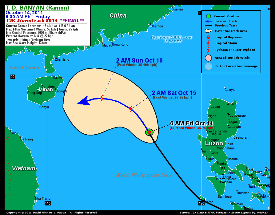
T2K Final TrackMap (for Public): 6 AM PhT Fri Oct 14
3-DAY FORECAST OUTLOOK & ANALYSIS*
BANYAN (RAMON) is expected to continue moving NW-ward during the next 24 hrs...with a sudden west to WSW turn through 72 hours. A decrease on its forward speed is likely during the outlook period. On the forecast track, the core of the depression will exit the Philippine Area of Responsibility (PAR) today...and will pass just to the south of Hainan Island on Monday.
Maximum Sustained Winds (1-min. avg) have increased to near 55 km/hr (30 knots) with higher gusts. BANYAN (RAMON) is a Tropical Depression (TD) on the Saffir-Simpson Tropical Cyclone Scale...and should re-intensify back to Tropical Storm status later today.
The following is the summary of the 3-day forecast outlook on this system:
 SATURDAY EARLY MORNING: Regains Tropical Storm status while outside of the Philippine Area of Responsibility (PAR)...turns WNW [2AM OCT 15: 18.6N 115.5E @ 75kph].
SUNDAY EARLY MORNING: Continues to gain strength as it turns West to WSW towards to the south of Hainan [2AM OCT 16: 18.7N 113.3E @ 85kph].
MONDAY EARLY MORNING: Passing to the south of Hainan Island while on a WSW track towards Vietnam [2AM OCT 17: 17.7N 110.9E @ 85kph].
*Please be reminded that the Forecast Outlook changes every 6 hours, and the Day 3 Forecast Track have an average error of 250 km...while the wind speed forecast error, averages 35 kph per day. Therefore, a turn to the left or right of its future track and changes in its wind speed must be anticipated from time to time.
EFFECTS & HAZARDS SUMMARY
Below is the summary of the storm's parts and its hazards affecting specific areas:
EASTERNMOST RAINBANDS - still affecting & spreading across the western portions of Central & Northern Luzon. Tropical Depression Conditions w/ moderate to strong winds (25-61 kph) will be expected along these bands (click here to know more about Rainbands). 24HR TOTAL RAINFALL ACCUMULATION - from 5 up to 100 mm (low to high rainfall) can be expected along areas affected by the rainbands (see above)...with isolated amounts of 101 to 250 mm (High) along areas near the center of BANYAN (RAMON). (click to open NOAA's eTRaP graphic).
Important Note: Please keep in mind that the above forecast outlook, effects-hazards, current monsoon intensity, & tropical cyclone watch changes every 6 to 12 hrs!![]()
External Links for TD BANYAN (RAMON)
PAGASA@Twitter: Hourly Updates
View NOAA-CIRA's: Latest Full Wind Analysis
JTWC Latest Tracking Chart: wp2311.gif
Multi-Agency Forecast TrackMap: Near Real-Time
TSR Wind Probabilities: Current to 5 days Ahead
JAXA TRMM Page: Latest Rainrate (in mm/hr)
Zoomed Satellite Pic: NOAA's Near Real-Time
Wunderground Animation: 6-12 hr. GIF Loop
TYPHOON2000 LATEST STORMTRACK:
>> To know the meteorological terminologies and acronyms used on this update visit the ff:
http://typhoon2000.ph/tcterm.htm
http://www.nhc.noaa.gov/aboutgloss.shtml
http://www.nhc.noaa.gov/acronyms.shtml
__________________________________________________________________________________________
For the complete details on TD BANYAN (RAMON)...go visit our website @:
> http://www.typhoon2000.com
> http://www.maybagyo.com
Copyright © 2011 Typhoon2000.com All Rights Reserved

No comments:
Post a Comment