
for Wednesday, 12 October 2011 [5:55 PM PhT]
![]()

<<<Typhoon2000.com Mobile >>>
Get the latest 6-hrly SMS Storm Alerts on RAMON!
For more details: Text T2K TYPHOON to
2800 (Globe/TM) | 216 (Smart/TNT) | 2288 (Sun)
*Only P2.50 (Smart/Globe) / P2.00 (Sun) per msg received.
Click here on how to use this service (in PDF file)
Powered by: Synermaxx Corporation
Typhoon2000 (T2K) NEWS (Tuesday Oct 11 2011):
Currently issuing 6-hrly web, SMS, email, & iTyphoon app updates (except 12:00 Midnight) on BANYAN (RAMON).
BANYAN (RAMON) MAX WIND SPEED PER AGENCY:
+ USA (JTWC/1-min avg): 55 km/hr
+ Japan (JMA/10-min avg): 65 km/hr
+ Philippines (PAGASA/10-min avg): 55 km/hr
+ Beijing (NMC/2-min avg): 65 km/hr
+ Taiwan (CWB/10-min avg): 65 km/hr
+ Korea (KMA/10-min avg): 65 km/hr
+ Hong Kong (HKO/10-min avg): 55 km/hr
:: Click here to see Multi-Agency Forecast Tracks
TROPICAL DEPRESSION BANYAN [RAMON/23W/1120]
T2K PUBLIC ADVISORY NUMBER 009
6:00 PM PhT (10:00 GMT) Wed 12 October 2011
Source: T2K Analysis/JTWC TC Warning #010/SatFixes
View: Advisory Archives (2004-2011)
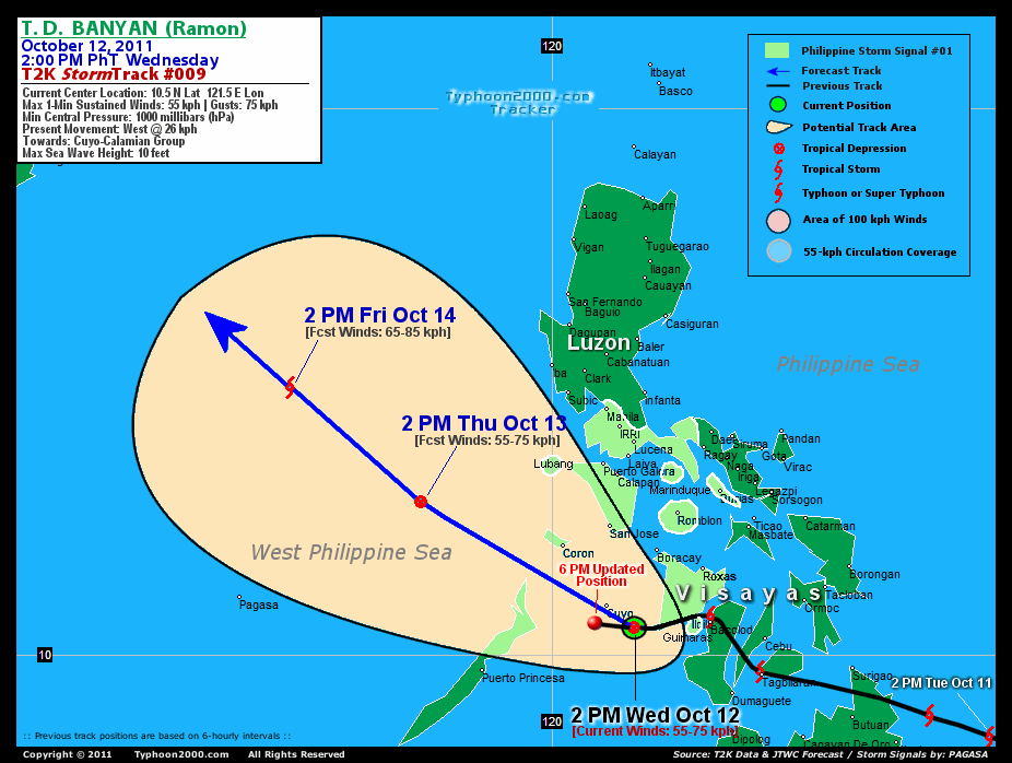
BANYAN (RAMON) downgraded to a Tropical Depression as it passed very near Cuyo Island...tracking Westward across the Sulu Sea in the direction of Northern Palawan & Calamian Group of Islands. Broad rainbands continuing to soak Western Visayas, Southern Luzon, Mindoro & Bicol Region.
Residents and visitors along Northern Palawan, Calamian Group & Mindoro should closely monitor the progress of BANYAN (RAMON).
Do not use this for life or death decision. This advisory is intended for additional information purposes only. Kindly refer to your country's official weather agency for local warnings, advisories & bulletins.
CURRENT STORM INFORMATION
Time/Date: 6:00 PM PhT Wed October 12 2011
Location of Center: 10.6º N Lat 120.8º E Lon
Distance 1: 40 km SSW of Cuyo Is.
Distance 2: 169 km SSE of Coron Is.
Distance 3: 188 km SW of Boracay
Distance 4: 203 km SSW of San Jose, Occ.Mindoro
Distance 5: 197 km West of Iloilo City
Distance 6: 205 km West of Guimaras
Distance 7: 229 km West of Bacolod City
Distance 8: 323 km South of Puerto Galera
Distance 9: 340 km SSW of Laiya, Batangas
Distance 10: 341 km WNW of Metro Cebu
Distance 11: 423 km SSW of Metro Naga/CWC
Distance 12: 446 km South of Metro Manila
MaxWinds (1-min avg): 55 kph (30 kts) near the center
Peak Wind Gusts: 75 kph (40 kts)
Present Movement: West @ 24 kph (13 kts)
Towards: Northern Palawan-Calamian Group Area
24hr Rainfall Accum (near center): 500 mm (VHigh)
Minimum Central Pressure: 1000 millibars (hPa)
Saffir-Simpson Typhoon Scale: Tropical Depression
Size (in Diameter): 665 km (360 nm) [Average]
Wind Area Distribution (in Knots): Current Wind Profile
Max Sea Wave Height (near center): 10 ft
Possible Storm Surge Height: 0 ft [0 m]
T2K TrackMap (for Public): 6 PM PhT Wed Oct 12
3-DAY FORECAST OUTLOOK & ANALYSIS*
BANYAN (RAMON) is expected to resume moving WNW to NW-ward during the next 2 to 3 days...with a decrease on its forward speed later in the forecast period. On the forecast track, the core of the depression will pass in between Calamian Group & Northern Palawan later tonight...and will move out into the West Philippine Sea Thursday. BANYAN will exit the Philippine Area of Responsibility (PAR) on Friday, on its way towards Southern China.
Maximum Sustained Winds (1-min. avg) have decreased to near 55 km/hr (30 knots) with higher gusts. BANYAN (RAMON) is just a Tropical Depression (TD) on the Saffir-Simpson Tropical Cyclone Scale...and should re-intensify as it moves into West Philippine Sea on Thursday.
The following is the summary of the 3-day forecast outlook on this system:
 THURSDAY AFTERNOON: Maintains its TD status as it moves across the West Philippine Sea [2PM OCT 13: 12.8N 117.6E @ 55kph].
FRIDAY AFTERNOON: Regains Tropical Storm (TS) status while moving NW across the West Philippine Sea...exits the Philippine Area of Responsibility (PAR) [2PM OCT 14: 14.9N 115.2E @ 65kph].
SATURDAY AFTERNOON: Becoming a strong TS while turning Westward towards Southern Hainan-Vietnam Area [2PM OCT 15: 17.0N 113.2E @ 85kph].
*Please be reminded that the Forecast Outlook changes every 6 hours, and the Day 3 Forecast Track have an average error of 250 km...while the wind speed forecast error, averages 35 kph per day. Therefore, a turn to the left or right of its future track and changes in its wind speed must be anticipated from time to time.
EFFECTS & HAZARDS SUMMARY
Below is the summary of the storm's parts and its hazards affecting specific areas:
RAINBANDS - affecting & spreading across the Visayas, Palawan, Mindoro, Southern Tagalog Provinces & Bicol Region. Tropical Depression Conditions w/ moderate to strong winds (25-61 kph) will be expected along these bands (click here to know more about Rainbands). 24HR TOTAL RAINFALL ACCUMULATION - from 5 up to 100 mm (low to high rainfall) can be expected along areas affected by the rainbands (see above)...with isolated amounts of 101 to 500 mm (high) along areas near the center of BANYAN (RAMON). (click to open NOAA's eTRaP graphic).
Important Note: Please keep in mind that the above forecast outlook, effects-hazards, current monsoon intensity, & tropical cyclone watch changes every 6 to 12 hrs!![]()
PAGASA Philippine Storm Warnings Signals
PHILIPPINE STORM WARNING SIGNAL # ONE (1) 
In Effect: PANAY, GUIMARAS, MARINDUQUE, MINDORO, LUBANG ISLAND, ROMBLON, SOUTHERN QUEZON, BURIAS ISLAND, NORTHERN PALAWAN, CALAMIAN GROUP OF ISLANDS, CAVITE, LAGUNA, BATANGAS, & METRO MANILA.
The above areas will have rains and winds of not more than 60 kph tonight until tomorrow. Coastal waters will be moderate to rough.
Residents living in low-lying and mountainous areas under Public Storm Warning Signals are alerted against flashfloods, mudslides and landslides...while those living in coastal & beach-front areas are advised to seek higher grounds due to possible storm surge (aka. big waves).
External Links for TD BANYAN (RAMON)
PAGASA@Twitter: Hourly Updates
View NOAA-CIRA's: Latest Full Wind Analysis
JTWC Latest Tracking Chart: wp2311.gif
Multi-Agency Forecast TrackMap: Near Real-Time
TSR Wind Probabilities: Current to 5 days Ahead
JAXA TRMM Page: Latest Rainrate (in mm/hr)
Zoomed Satellite Pic: NOAA's Near Real-Time
Wunderground Animation: 6-12 hr. GIF Loop
TYPHOON2000 LATEST STORMTRACK:
>> To know the meteorological terminologies and acronyms used on this update visit the ff:
http://typhoon2000.ph/tcterm.htm
http://www.nhc.noaa.gov/aboutgloss.shtml
http://www.nhc.noaa.gov/acronyms.shtml
__________________________________________________________________________________________
For the complete details on TD BANYAN (RAMON)...go visit our website @:
> http://www.typhoon2000.com
> http://www.maybagyo.com
Copyright © 2011 Typhoon2000.com All Rights Reserved

No comments:
Post a Comment