Saturday, August 31, 2013

XT KONG-REY (NANDO) Final Update


for Saturday, 31 August 2013 [9:12 AM PhT]

WEATHER.COM.PH TROPICAL CYCLONE UPDATES

EXTRATROPICAL CYCLONE KONG-REY (NANDO) UPDATE NUMBER 013 [FINAL]

Issued at: 8:30 AM PhT (00:30 GMT) Saturday 31 August 2013

KONG-REY (NANDO) becomes an Extratropical (Middle-Latitude) Cyclone as it races towards the Northern Coast of Kyushu at accelerating speeds.

This storm will continue to enhance the Southwest Monsoon (Hanging Habagat) - bringing mostly cloudy and breezy conditions with occasional slight to moderate to sometimes heavy rains or thunderstorms across the East China Sea, Taiwan Strait and Taiwan. The threat of flash floods and landslides are likely in hazard-prone areas especially along river banks and mountain slopes of the affected areas. Residents are advised to take necessary precautions.

*This is the last and final update on Kong-Rey (Nando).


Do not use this for life or death decisions. This update is intended for additional information purposes only. Kindly refer to your national weather agency for official warnings, advisories or bulletins.


CURRENT STORM ANALYSIS

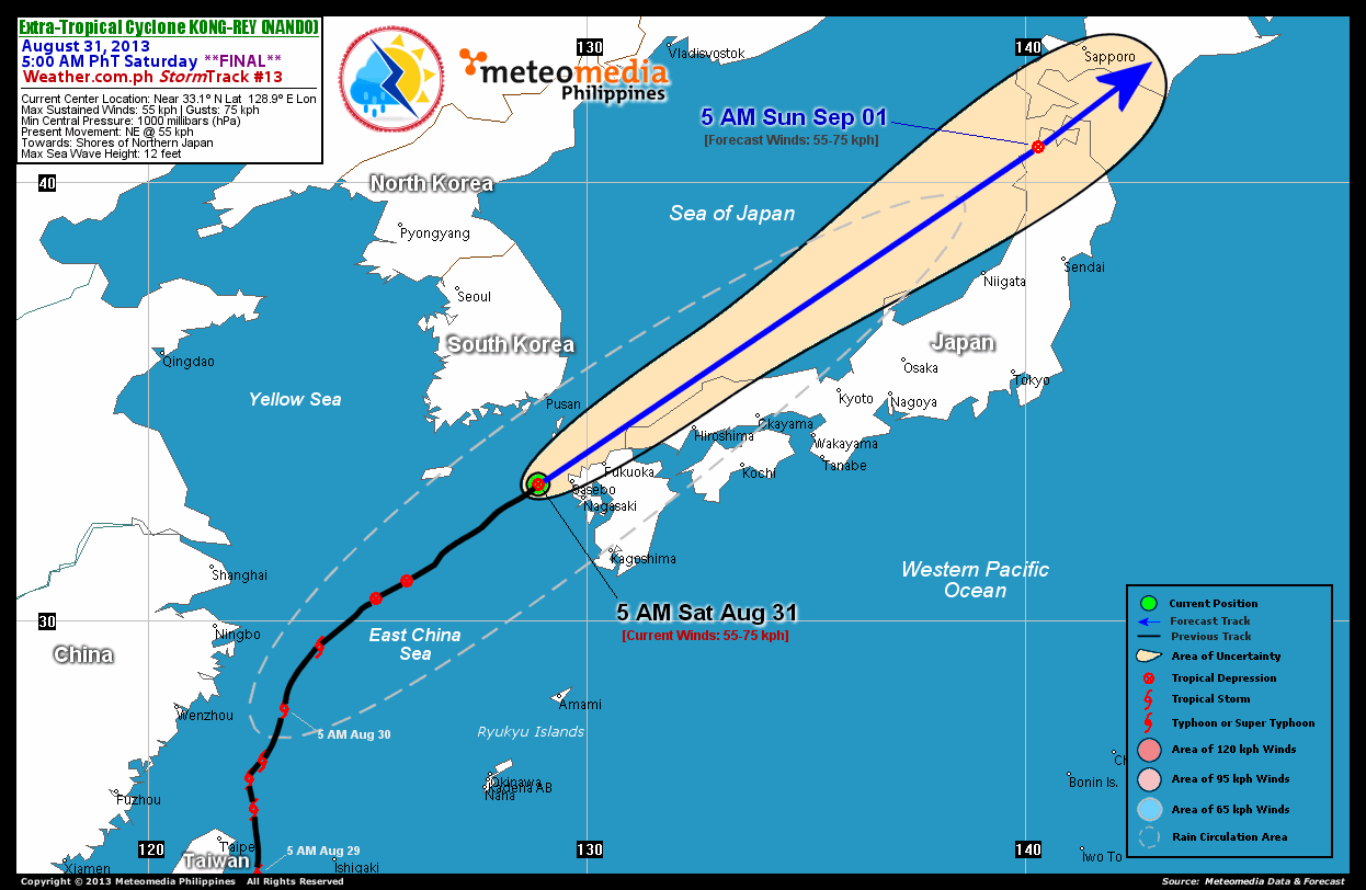
As of 5:00 am today, the center of Extratropical Cyclone (XT) Kong-Rey (Nando) was located over the northwestern shores of Kyushu, Japan...about 75 km west of Sasebo, Japan or 235 km south of Busan, South Korea...currently moving northeast with a rapidly increased forward speed of 55 km/hr towards Northern Japan.

Maximum Sustained Winds (1-min. avg) remained at 55 km/hr near the center with higher gusts. Kong-Rey (Nando) remains an average-sized tropical cyclone with a diameter of 390 kilometers across. The 24-hour rainfall accumulation near the center of Kong-Rey (Nando) is estimated to be extreme (400 mm).


1-DAY FORECAST OUTLOOK*

XT Kong-Rey (Nando) is expected to continue to move rapidly northeastward throughout the forecast period. On the forecast track, the core of Kong-Rey (Nando) will be passing along the northern shores of Northern Japan today and will be over the Northeastern Honshu-Hokkaido Area on Sunday morning.

XT Kong-Rey (Nando) is now an Extratropical (Mid-latitude) Cyclone and its strength will remain at 55 kph until it begins to weaken. Advance Intensity Forecast (AIF) shows a 1-minute sustained winds of just 45 km/hr late Sunday.

The following is the summary of the 1-day forecast outlook on this system:

SUNDAY MORNING: Moving swiftly across the northeastern tip of Honshu...about 285 km north-northwest of Sendai, Japan [5AM SEP 01: 40.8N 140.3E @ 55kph].

*Please be reminded that the Forecast Outlook changes every 6 hours, and the Day 2 and 3 Forecast Tracks have an average error of 100 and 250 km respectively...while the wind speed forecast error, averages 35 kph per day. Therefore, a turn to the left or right of its future track and changes in its wind speed must be anticipated from time to time.


EFFECTS & HAZARDS SUMMARY

Below is the summary of the storm's parts and its hazards affecting specific areas. You can also view this image link for you to understand the parts.

DECAYING RAINBANDS - where Tropical Depression Conditions with light, moderate to strong winds (30-62 kph) will be expected. Affected Areas: East China Sea, Northwestern and Northern Japan, and the Sea of Japan (click here to know more about Rainbands).
24HR TOTAL RAINFALL ACCUMULATION - from 5 up to 100 mm (slight to heavy rainfall) can be expected along areas affected by the outer & inner rainbands (see above)...with isolated amounts of 100 to 400 mm (heavy to extreme) along areas near the center of Kong-Rey (Nando).

Important Note: Please keep in mind that the above forecast outlook, effects and hazards summary changes every 6 to 12 hrs!


CURRENT TECHNICAL INFORMATION

Time/Date: 5:00 AM PhT Sat Aug 31, 2013
Class/Name: XT Kong-Rey (Nando)
Location of Center: Near 33.1º N Lat 128.9º E Lon
Distance 1: 75 km W of Sasebo, Japan
Distance 2: 215 km ESE of Jeju Island
Distance 3: 235 km S of Busan, South Korea
Distance 4: 100 km WNW of Nagasaki, Japan
MaxWinds (1-min avg): 55 kph near the center
Peak Wind Gusts: 75 kph
Present Movement: NE @ 55 kph
Towards: Northern Shores of Japan
24hr Rainfall Accum (SW of Center): Extreme [400 mm]
Minimum Central Pressure: 1000 millibars (hPa)
Size (in Diameter): 390 km [Average]
Max Sea Wave Height (near center): 12 feet
T2K/WP StormTracks (for Public): GIF | Google Map (Flash)

__________________________________________________________________________________________________

CURRENT TRACKING MAP:

http://www.typhoon2000.ph/advisorytrax/2013/nando13.gif _____________________________________________________________________________


CURRENT NOAA/MTSAT-2 SATELLITE ANIMATION:

http://weather.com.ph/images/20130831003641.gif
__________________________________________________________________________________________________

CURRENT NOAA/MTSAT-2 INFRARED (IR) SATELLITE IMAGE
:


http://www.ssd.noaa.gov/PS/TROP/floaters/14W/imagery/rbtop0-lalo.jpg

__________________________________________________________________________________________________


NOTE:

>> To know the meteorological terminologies and acronyms used on this update visit the ff:

   
http://typhoon2000.ph/tcterm.htm  
   
http://www.nhc.noaa.gov/aboutgloss.shtml
    http://www.nhc.noaa.gov/acronyms.shtml
__________________________________________________________________________________________

For the complete details on XT KONG-REY (NANDO)...go visit our website @:

>
http://www.typhoon2000.com
http://www.maybagyo.com

:: Kindly view our site's disclaimer at: 
   
http://www.typhoon2000.ph/disclaimer.htm
__________________________________________________________________________________________

<<<Typhoon2000.com Mobile >>>
Get the latest SMS Storm Alerts!
For more details: Text T2K TYPHOON to

2800 (Globe/TM) | Offline (Smart/TNT) | 2288 (Sun)
*Only P2.50 (Smart/Globe) / P2.00 (Sun) per msg received.

Click here on how to use this service (in PDF file)
Powered by: Synermaxx Corporation


Copyright © 2013 Typhoon2000.com     All Rights Reserved

__._,_.___
Reply via web post Reply to sender Reply to group Start a New Topic Messages in this topic (1)
Recent Activity:
.

__,_._,___

Friday, August 30, 2013

TD KONG-REY (NANDO) Update #012


for Friday, 30 August 2013 [7:51 PM PhT]

WEATHER.COM.PH TROPICAL CYCLONE UPDATES

TROPICAL DEPRESSION KONG-REY (NANDO) UPDATE NUMBER 012
Issued: 7:15 PM PhT (11:15 GMT) Friday 30 August 2013

KONG-REY (NANDO) has weakened into a Tropical Depression as it veered to the northeast...now heading towards Northern Kyushu...its rain circulation remains over Northern Taiwan.

This storm will continue to enhance the Southwest Monsoon (Hanging Habagat) - bringing mostly cloudy and breezy conditions with occasional slight to moderate to sometimes heavy rains or thunderstorms across the northern part of the South China Sea, Taiwan Strait and Southern Taiwan. The threat of flash floods and landslides are likely in hazard-prone areas especially along river banks and mountain slopes of the affected areas. Residents are advised to take necessary precautions.


Residents and visitors along Western and Southern Japan should closely monitor the development of Kong-Rey (Nando).

Do not use this for life or death decisions. This update is intended for additional information purposes only. Kindly refer to your national weather agency for official warnings, advisories or bulletins.


CURRENT STORM ANALYSIS

As of 5:00 pm today, the center of TD Kong-Rey (Nando) was located over the East China Sea...about 700 km north-northeast of Taipei, Taiwan or 515 km southwest of Sasebo, Japan...currently moving northeast with an increased forward speed of 30 km/hr towards Northern Kyushu, Japan.

Maximum Sustained Winds (1-min. avg) are at 55 km/hr near the center with higher gusts. Kong-Rey (Nando) remains an average-sized tropical cyclone with a diameter of 390 kilometers across. The 24-hour rainfall accumulation to the southwest of the center of Kong-Rey (Nando) is estimated to be heavy (100 mm).


2-DAY FORECAST OUTLOOK*

TD Kong-Rey (Nando) is expected to continue to move northeastward throughout the forecast period. On the forecast track, the core of Kong-Rey (Nando) will pass along the northern shores of Western Japan by Saturday morning and will be over the Sea of Japan by Saturday afternoon. By Sunday afternoon, Kong-rey will be over the Pacific Ocean just to the south of Hokkaido after traversing Northern Honshu (Japan).

TD Kong-Rey (Nando) could still re-intensify within the next 12 to 24 hours before losing strength through 48 hours...and will become an Extratropical (Mid-latitude) Cyclone on Saturday morning. Advance Intensity Forecast (AIF) shows Kong-Rey (Nando) reaching a 1-minute sustained winds of 65 km/hr on Saturday morning.

The following is the summary of the 2-day forecast outlook on this system:

SATURDAY AFTERNOON: Re-intensifies slightly while over the Sea of Japan, as it accelerates toward Northern Honshu...about 160 km northwest of Kyoto, Japan [5PM AUG 31: 36.3N 134.4E @ 65kph].
SUNDAY AFTERNOON: Over the Pacific Ocean just south of Hokkaido (Japan)...weakens into an area of low pressure...about 390 km east of Sapporo, Japan [5PM SEP 01: 42.9N 146.2E @ 45kph].

*Please be reminded that the Forecast Outlook changes every 6 hours, and the Day 2 and 3 Forecast Tracks have an average error of 100 and 250 km respectively...while the wind speed forecast error, averages 35 kph per day. Therefore, a turn to the left or right of its future track and changes in its wind speed must be anticipated from time to time.


EFFECTS & HAZARDS SUMMARY

Below is the summary of the storm's parts and its hazards affecting specific areas. You can also view this image link for you to understand the parts.

DECAYING RAINBANDS - where Tropical Depression Conditions with light, moderate to strong winds (30-62 kph) will be expected. Affected Areas: Northern Taiwan and rest of East China Sea (click here to know more about Rainbands).
24HR TOTAL RAINFALL ACCUMULATION - from 5 up to 25 mm (slight to moderate rainfall) can be expected along areas affected by the outer & inner rainbands (see above)...with isolated amounts of 26 to 100 mm (moderate to heavy) along areas to the southwest of the center of Kong-Rey (Nando).

Important Note: Please keep in mind that the above forecast outlook, effects and hazards summary changes every 6 to 12 hrs!


CURRENT TECHNICAL INFORMATION

Time/Date: 5:00 PM PhT Fri Aug 30, 2013
Class/Name: TD Kong-Rey (Nando)
Location of Center: Near 30.5º N Lat 125.2º E Lon
Distance 1: 520 km NE of Wenzhou, China
Distance 2: 360 km ENE of Ningbo, China
Distance 3: 700 km NNE of Taipei, Taiwan
Distance 4: 510 km NW of Okinawa, Japan
MaxWinds (1-min avg): 55 kph near the center
Peak Wind Gusts: 75 kph
Present Movement: NE @ 30 kph
Towards: Northern Kyushu, Japan
24hr Rainfall Accum (SW of Center): Heavy [100 mm]
Minimum Central Pressure: 1000 millibars (hPa)
Size (in Diameter): 390 km [Average]
Max Sea Wave Height (near center): 14 feet
T2K/WP StormTracks (for Public): GIF | Google Map (Flash)

__________________________________________________________________________________________________

CURRENT TRACKING MAP:

http://www.typhoon2000.ph/advisorytrax/2013/nando12.gif _____________________________________________________________________________


CURRENT NOAA/MTSAT-2 SATELLITE ANIMATION:

http://weather.com.ph/images/20130830111733.gif
__________________________________________________________________________________________________

CURRENT NOAA/MTSAT-2 INFRARED (IR) SATELLITE IMAGE
:


http://www.ssd.noaa.gov/PS/TROP/floaters/14W/imagery/rbtop0-lalo.jpg

__________________________________________________________________________________________________


NOTE:

>> To know the meteorological terminologies and acronyms used on this update visit the ff:

   
http://typhoon2000.ph/tcterm.htm  
   
http://www.nhc.noaa.gov/aboutgloss.shtml
    http://www.nhc.noaa.gov/acronyms.shtml
__________________________________________________________________________________________

For the complete details on TD KONG-REY (NANDO)...go visit our website @:

>
http://www.typhoon2000.com
http://www.maybagyo.com

:: Kindly view our site's disclaimer at: 
   
http://www.typhoon2000.ph/disclaimer.htm
__________________________________________________________________________________________

<<<Typhoon2000.com Mobile >>>
Get the latest SMS Storm Alerts!
For more details: Text T2K TYPHOON to

2800 (Globe/TM) | Offline (Smart/TNT) | 2288 (Sun)
*Only P2.50 (Smart/Globe) / P2.00 (Sun) per msg received.

Click here on how to use this service (in PDF file)
Powered by: Synermaxx Corporation


Copyright © 2013 Typhoon2000.com     All Rights Reserved

__._,_.___
Reply via web post Reply to sender Reply to group Start a New Topic Messages in this topic (1)
Recent Activity:
.

__,_._,___

TS KONG-REY (NANDO) Update #011


for Friday, 30 August 2013 [7:49 AM PhT]

WEATHER.COM.PH TROPICAL CYCLONE UPDATES

TROPICAL STORM KONG-REY (NANDO) UPDATE NUMBER 011
Issued: 7:30 AM PhT (23:30 GMT) Friday 30 August 2013

Tropical Storm KONG-REY (NANDO) now starting to move towards Western Japan...its rain circulation remains over Northern Taiwan.

This storm will continue to enhance the Southwest Monsoon (Hanging Habagat) - bringing mostly cloudy and breezy conditions with occasional slight to moderate to sometimes heavy rains or thunderstorms across the northern part of the South China Sea, Taiwan Strait and Southern Taiwan. The threat of flash floods and landslides are likely in hazard-prone areas especially along river banks and mountain slopes of the affected areas. Residents are advised to take necessary precautions.


Residents and visitors along Western and Southern Japan should closely monitor the development of Kong-Rey (Nando).

Do not use this for life or death decisions. This update is intended for additional information purposes only. Kindly refer to your national weather agency for official warnings, advisories or bulletins.


CURRENT STORM ANALYSIS

As of 5:00 am today, the center of TS Kong-Rey (Nando) was located over the East China Sea...about 365 km north-northeast of Taipei, Taiwan or 235 km east of Wenzhou, China...currently moving north-northeast with an increased forward speed of 22 km/hr towards Western Japan.

Maximum Sustained Winds (1-min. avg) are at 75 km/hr near the center with higher gusts. Tropical Storm Force Winds (63-117 km/hr) extend outward up to 65 kilometers from the center. Kong-Rey (Nando) remains an average-sized tropical cyclone with a diameter of 500 kilometers across. The 24-hour rainfall accumulation to the southwest of the center of Kong-Rey (Nando) is estimated to be heavy (300 mm).


2-DAY FORECAST OUTLOOK*

TS Kong-Rey (Nando) is expected to move northeast to east-northeast with a rapid increase in forward speed throughout the forecast period. On the forecast track, the core of Kong-Rey (Nando) will remain over the East China Sea through the next 24 hours...and will make landfall over Western Kyushu (Japan) on Saturday afternoon. By Sunday morning, the storm will be over the northern coast of Honshu (Japan) after traversing Kyushu and Western Honshu.

TS Kong-Rey (Nando) could still re-intensify within the next 12 to 24 hours before losing strength through 48 hours...and will become an Extratropical (Mid-latitude) Cyclone on Saturday afternoon. Advance Intensity Forecast (AIF) shows Kong-Rey (Nando) reaching a 1-minute sustained winds of 85 km/hr on Saturday morning.

The following is the summary of the 2-day forecast outlook on this system:

SATURDAY MORNING: Re-intensifies slightly while over the East China Sea, as it accelerates toward Western Japan...about 390 km southwest of Nagasaki, Japan [5AM AUG 31: 30.8N 126.5E @ 85kph].
SUNDAY MORNING: Over the northern coast of Honshu (Japan)...becomes Extratropical...about 70 km northwest of Kyoto, Japan [5AM SEP 01: 35.6N 135.2E @ 75kph].

*Please be reminded that the Forecast Outlook changes every 6 hours, and the Day 2 and 3 Forecast Tracks have an average error of 100 and 250 km respectively...while the wind speed forecast error, averages 35 kph per day. Therefore, a turn to the left or right of its future track and changes in its wind speed must be anticipated from time to time.


EFFECTS & HAZARDS SUMMARY

Below is the summary of the storm's parts and its hazards affecting specific areas. You can also view this image link for you to understand the parts.

INNER RAINBANDS - where Tropical Storm Conditions with Tropical Storm Force Winds (63-95 kph) will be expected. Affected Areas: Southern part of the East China Sea.
OUTER RAINBANDS - where Tropical Depression Conditions with light, moderate to strong winds (30-62 kph) will be expected. Affected Areas: Coastal areas of Fujian and Eastern Guangdong (China), Northern Taiwan and Taiwan Strait (click here to know more about Rainbands).
24HR TOTAL RAINFALL ACCUMULATION - from 5 up to 200 mm (slight to heavy rainfall) can be expected along areas affected by the outer & inner rainbands (see above)...with isolated amounts of 201 to 300 mm (heavy) along areas to the southwest of the center of Kong-Rey (Nando).

Important Note: Please keep in mind that the above forecast outlook, effects and hazards summary changes every 6 to 12 hrs!


CURRENT TECHNICAL INFORMATION

Time/Date: 5:00 AM PhT Fri Aug 30, 2013
Class/Name: TS Kong-Rey (Nando)
Location of Center: Near 28.0º N Lat 123.1º E Lon
Distance 1: 235 km E of Wenzhou, China
Distance 2: 260 km SE of Ningbo, China
Distance 3: 365 km NNE of Taipei, Taiwan
Distance 4: 495 km WNW of Okinawa, Japan
MaxWinds (1-min avg): 75 kph near the center
Peak Wind Gusts: 95 kph
Present Movement: NNE @ 22 kph
Towards: Western Japan
24hr Rainfall Accum (SW of Center): Heavy [300 mm]
Minimum Central Pressure: 993 millibars (hPa)
Size (in Diameter): 500 km [Average]
Max Sea Wave Height (near center): 16 feet
T2K/WP StormTracks (for Public): GIF | Google Map (Flash)

__________________________________________________________________________________________________

CURRENT TRACKING MAP:

http://www.typhoon2000.ph/advisorytrax/2013/nando11.gif _____________________________________________________________________________


CURRENT NOAA/MTSAT-2 SATELLITE ANIMATION:

http://weather.com.ph/images/20130829233927.gif
__________________________________________________________________________________________________

CURRENT NOAA/MTSAT-2 INFRARED (IR) SATELLITE IMAGE
:


http://www.ssd.noaa.gov/PS/TROP/floaters/14W/imagery/rbtop0-lalo.jpg

__________________________________________________________________________________________________


NOTE:

>> To know the meteorological terminologies and acronyms used on this update visit the ff:

   
http://typhoon2000.ph/tcterm.htm  
   
http://www.nhc.noaa.gov/aboutgloss.shtml
    http://www.nhc.noaa.gov/acronyms.shtml
__________________________________________________________________________________________

For the complete details on TS KONG-REY (NANDO)...go visit our website @:

>
http://www.typhoon2000.com
http://www.maybagyo.com

:: Kindly view our site's disclaimer at: 
   
http://www.typhoon2000.ph/disclaimer.htm
__________________________________________________________________________________________

<<<Typhoon2000.com Mobile >>>
Get the latest SMS Storm Alerts!
For more details: Text T2K TYPHOON to

2800 (Globe/TM) | Offline (Smart/TNT) | 2288 (Sun)
*Only P2.50 (Smart/Globe) / P2.00 (Sun) per msg received.

Click here on how to use this service (in PDF file)
Powered by: Synermaxx Corporation


Copyright © 2013 Typhoon2000.com     All Rights Reserved

__._,_.___
Reply via web post Reply to sender Reply to group Start a New Topic Messages in this topic (1)
Recent Activity:
.

__,_._,___

Thursday, August 29, 2013

TS KONG-REY (NANDO) Update #010


for Thursday, 29 August 2013 [6:29 PM PhT]

WEATHER.COM.PH TROPICAL CYCLONE UPDATES

TROPICAL STORM KONG-REY (NANDO) UPDATE NUMBER 010
Issued: 6:00 PM PhT (10:00 GMT) Thursday 29 August 2013

Tropical Storm KONG-REY (NANDO) has jogged slightly to the NNW as it continues to weaken while over the East China Sea. Its southern circulation continues to dump rains across Taiwan.

This storm will slightly induce the Southwest Monsoon (Hanging Habagat) - bringing mostly cloudy and breezy conditions with occasional slight to moderate to sometimes heavy rains or thunderstorms across the Batanes Islands. The threat of flash floods and landslides are likely in hazard-prone areas especially along river banks and mountain slopes of the affected areas. Residents are advised to take necessary precautions.


Residents and visitors along Western and Southern Japan should closely monitor the development of Kong-Rey (Nando).

Do not use this for life or death decisions. This update is intended for additional information purposes only. Kindly refer to your national weather agency for official warnings, advisories or bulletins.


CURRENT STORM ANALYSIS

As of 5:00 pm today, the center of TS Kong-Rey (Nando) was located over the East China Sea...about 190 km north-northeast of Taipei, Taiwan or 215 km southeast of Wenzhou, China...currently moving north-northwest with a decreased forward speed of 13 km/hr towards the East China Sea.

Maximum Sustained Winds (1-min. avg) have decreased to 75 km/hr near the center with higher gusts. Tropical Storm Force Winds (63-117 km/hr) extend outward up to 75 kilometers from the center. Kong-Rey (Nando) remains an average-sized tropical cyclone with a diameter of 500 kilometers across. The 24-hour rainfall accumulation to the southwest of the center of Kong-Rey (Nando) is estimated to be extreme (400 mm).


2-DAY FORECAST OUTLOOK*

TS Kong-Rey (Nando) is expected to recurve north-northeast to northeast with a rapid increase in forward speed through 24 hours...and will move more rapidly east-northwestward by 48 hours. On the forecast track, the core of Kong-Rey (Nando) will remain over the East China Sea through the next 36 hours...and will make landfall over Western Kyushu (Japan) on Saturday afternoon.

TS Kong-Rey (Nando) will continue to lose strength throughout the forecast period...and will become an Extratropical (Mid-latitude) Cyclone on Saturday. Advance Intensity Forecast (AIF) shows Kong-Rey (Nando) decreasing its 1-minute sustained winds to just 65 km/hr by Friday and Saturday.

The following is the summary of the 2-day forecast outlook and an extended 3-day forecast on this system:

FRIDAY AFTERNOON: Continues to weaken as it recurves towards the east-northeast across the East China Sea...about 300 km east of Ningbo, China [5PM AUG 30: 29.9N 124.6E @ 65kph].
SATURDAY AFTERNOON: Makes landfall over Western Kyushu...becomes Extratropical...about 95 km east of Fukuoka, Japan [5PM AUG 31: 33.7N 131.4E @ 65kph].
SUNDAY AFTERNOON: Weakens further as it moves faster across the northern part of Honshu (Japan)...remains an Extratropical Cyclone...about 210 km north-northwest of Sendai, Japan [5PM SEP 01: 40.0N 140.2E @ 55kph].

*Please be reminded that the Forecast Outlook changes every 6 hours, and the Day 2 and 3 Forecast Tracks have an average error of 100 and 250 km respectively...while the wind speed forecast error, averages 35 kph per day. Therefore, a turn to the left or right of its future track and changes in its wind speed must be anticipated from time to time.


EFFECTS & HAZARDS SUMMARY

Below is the summary of the storm's parts and its hazards affecting specific areas. You can also view this image link for you to understand the parts.

INNER RAINBANDS - where Tropical Storm Conditions with Tropical Storm Force Winds (63-95 kph) will be expected. Affected Areas: Southern part of the East China Sea.
OUTER RAINBANDS - where Tropical Depression Conditions with light, moderate to strong winds (30-62 kph) will be expected. Affected Areas: Coastal areas of Fujian and Eastern Guangdong (China), Rest of Taiwan and Taiwan Strait (click here to know more about Rainbands).
24HR TOTAL RAINFALL ACCUMULATION - from 5 up to 200 mm (slight to heavy rainfall) can be expected along areas affected by the outer & inner rainbands (see above)...with isolated amounts of 201 to 400 mm (heavy to extreme) along areas to the southwest of the center of Kong-Rey (Nando).

Important Note: Please keep in mind that the above forecast outlook, effects and hazards summary changes every 6 to 12 hrs!


CURRENT TECHNICAL INFORMATION

Time/Date: 5:00 PM PhT Thu Aug 29, 2013
Class/Name: TS Kong-Rey (Nando)
Location of Center: Near 26.6º N Lat 122.2º E Lon
Distance 1: 190 km NNE of Taipei, Taiwan
Distance 2: 215 km SE of Wenzhou, China
Distance 3: 310 km NW of Ishigakijima
Distance 4: 555 km W of Okinawa, Japan
MaxWinds (1-min avg): 75 kph near the center
Peak Wind Gusts: 95 kph
Present Movement: NNW @ 13 kph
Towards: East China Sea
24hr Rainfall Accum (SW of Center): Extreme [400 mm]
Minimum Central Pressure: 993 millibars (hPa)
Size (in Diameter): 500 km [Average]
Max Sea Wave Height (near center): 16 feet
T2K/WP StormTracks (for Public): GIF | Google Map (Flash)

__________________________________________________________________________________________________

CURRENT TRACKING MAP:

http://www.typhoon2000.ph/advisorytrax/2013/nando10.gif _____________________________________________________________________________


CURRENT NOAA/MTSAT-2 SATELLITE ANIMATION:

http://weather.com.ph/images/20130829101637.gif
__________________________________________________________________________________________________

CURRENT NOAA/MTSAT-2 INFRARED (IR) SATELLITE IMAGE
:


http://www.ssd.noaa.gov/PS/TROP/floaters/14W/imagery/rbtop0-lalo.jpg

__________________________________________________________________________________________________


NOTE:

>> To know the meteorological terminologies and acronyms used on this update visit the ff:

   
http://typhoon2000.ph/tcterm.htm  
   
http://www.nhc.noaa.gov/aboutgloss.shtml
    http://www.nhc.noaa.gov/acronyms.shtml
__________________________________________________________________________________________

For the complete details on TS KONG-REY (NANDO)...go visit our website @:

>
http://www.typhoon2000.com
http://www.maybagyo.com

:: Kindly view our site's disclaimer at: 
   
http://www.typhoon2000.ph/disclaimer.htm
__________________________________________________________________________________________

<<<Typhoon2000.com Mobile >>>
Get the latest SMS Storm Alerts!
For more details: Text T2K TYPHOON to

2800 (Globe/TM) | Offline (Smart/TNT) | 2288 (Sun)
*Only P2.50 (Smart/Globe) / P2.00 (Sun) per msg received.

Click here on how to use this service (in PDF file)
Powered by: Synermaxx Corporation


Copyright © 2013 Typhoon2000.com     All Rights Reserved

__._,_.___
Reply via web post Reply to sender Reply to group Start a New Topic Messages in this topic (1)
Recent Activity:
.

__,_._,___