
for Tuesday, 20 August 2013 [2:30 PM PhT]
WEATHER.COM.PH TROPICAL CYCLONE UPDATES
TROPICAL STORM TRAMI (MARING) UPDATE NUMBER 009
Issued: 12:00 NN PhT (04:00 GMT) Tuesday 20 August 2013
Next Update: 6:00 PM PhT (10:00 GMT) Tuesday 20 August 2013
Tropical Storm TRAMI (MARING) has maintained its strength for the past 6 hours as it continues to move generally northward across the North Philippine Sea.
This storm will continue to induce the Southwest Monsoon (Hanging Habagat) - bringing cloudy and windy conditions with "on-and-off" slight to moderate to sometimes heavy rains across the western sections of Luzon and Visayas...becoming more frequent with moderate-to-heavy monsoon rains along Mindoro, the National Capital Region (Metro Manila), Zambales, Cordillera Administrative Region, and CaLaBaRZon today through Wednesday. Flash floods and landslides are likely in hazard-prone areas especially along river banks and mountain slopes.
Meanwhile, Tropical Storm (TS) PEWA (01C) continues to lose strength while moving across the open seas of the Western Pacific Ocean. Latest dynamic forecast models continues to show the system moving generally northwestward for the next 2 days. Its center was located about 995 km southeast of Wake Island or 5,440 km east of the Philippines (15.7N Lat 175.2E Lon)...with maximum winds of 100 km/hr near the center...moving NW @ 15 kph. This storm remains too far away to affect any part of the Philippines.
Residents and visitors along Taiwan and the islands of Okinawa-Ryukyu-Miyako-Yaeyama-Ishigaki-Batanes Islands should closely monitor the development of Trami (Maring).
Do not use this for life or death decisions. This update is intended for additional information purposes only. Kindly refer to your national weather agency for official warnings, advisories or bulletins.
CURRENT STORM ANALYSIS
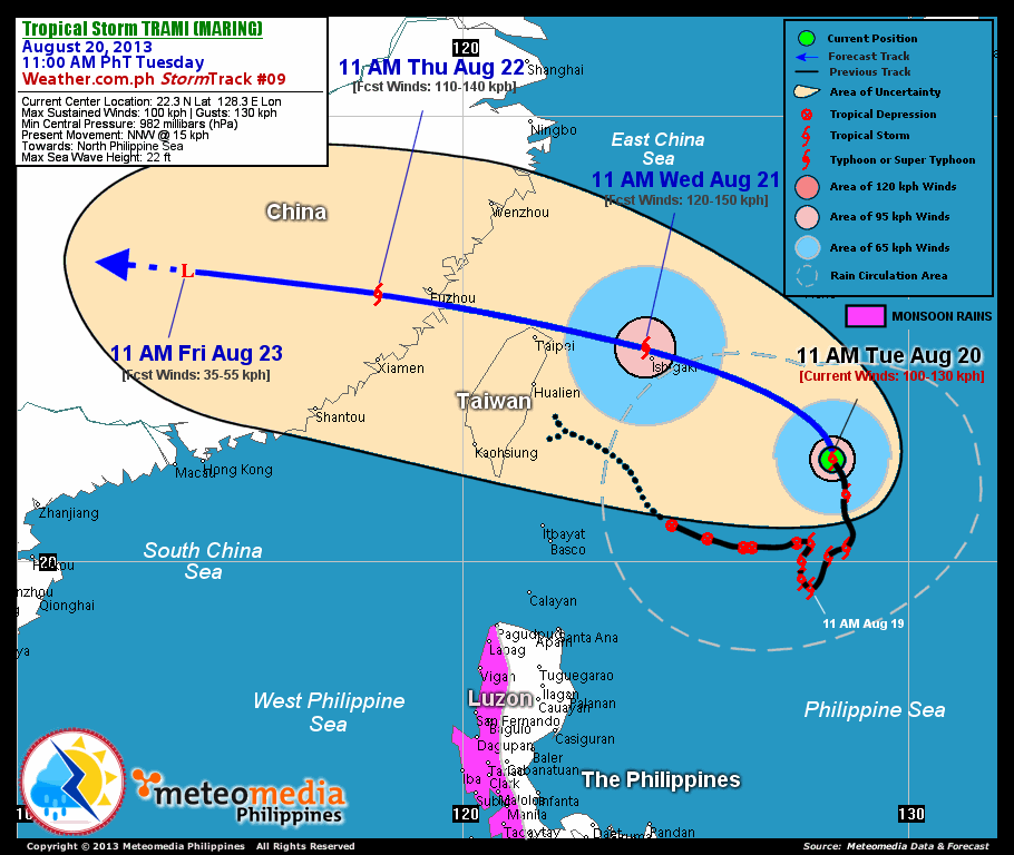
As of 11:00 am today, the center of TS Trami (Maring) was located over the North Philippine Sea...about 690 km east-northeast of Basco, Batanes or 470 km south of Okinawa, Japan...currently moving north-northwest with a forward speed of 15 km/hr.
Maximum Sustained Winds (1-min. avg) have increased to near 100 km/hr near the center with higher gusts. Tropical Storm Force Winds (63-100 km/hr) extend outward up to 140 kilometers from the center. Trami (Maring) remains an average-sized tropical cyclone with a diameter of 500 kilometers across. The 24-hour rainfall accumulation near the center of Trami (Maring) is estimated to be extreme (400 mm).
2-DAY FORECAST OUTLOOK*
TS Trami (Maring) is expected to move north-northwest to northwest and west-northwest during the next 12 to 24 hours...and continues to move west-northwest by 48 hours. On the forecast track, the core of Trami (Maring) will be passing over the Miyako and Yaeyama Island Group, very close to Ishigakijima on Wednesday noon...and will pass over the shores of Northern Taiwan by Wednesday evening...making landfall over Fujian Province, just close south of Fuzhou City by Thursday early morning. By Friday morning, Trami (Maring) will be over Jiangxi Province moving across land.
Trami (Maring) is expected to continue gaining strength within the next 12 to 24 hours...and could become a Typhoon on Wednesday morning. Advance Intensity Forecast (AIF) shows Trami (Maring) reaching its peak winds of 130 km/hr on Wednesday evening.
The following is the summary of the 2-day forecast outlook and an extended 3-day forecast on this system:
 WEDNESDAY MORNING: Becomes a minimal Typhoon...begins its westerly turn towards the northern shores of Taiwan...about 40 km northwest of Ishigakijima [11AM AUG 21: 24.8N 124.1E @ 120kph].
THURSDAY MORNING: Reaches its peak intensity as it passes over the northern coast of Taiwan...approaching Southeastern China (Fujian Province)...about 120 km west-southwest of Fuzhou, China [11AM AUG 22: 26.0N 118.1E @ 110kph].
FRIDAY MORNING: Over Jiangxi Province...dissipating over land...weakens to an area of low pressure...about 550 km west-northwest of Fuzhou, China [11AM AUG 23: 26.5N 113.8E @ 35kph].
*Please be reminded that the Forecast Outlook changes every 6 hours, and the Day 2 and 3 Forecast Tracks have an average error of 100 and 250 km respectively...while the wind speed forecast error, averages 35 kph per day. Therefore, a turn to the left or right of its future track and changes in its wind speed must be anticipated from time to time.
EFFECTS & HAZARDS SUMMARY
Below is the summary of the storm's parts and its hazards affecting specific areas. You can also view this image link for you to understand the parts.
CENTRAL DENSE OVERCAST (CDO) - where Near-Typhoon Conditions w/ Near-Typhoon Force Winds (100-130 kph) will be expected along the CDO (click here to know more about CDO). Possible "Eye" may also be forming underneath the cirrus canopy. Affected Areas: North Philippine Sea. INNER RAINBANDS - where Tropical Storm Conditions with Tropical Storm Force Winds (63-99 kph) will be expected. Affected Areas: North Philippine Sea. OUTER RAINBANDS - where Tropical Depression Conditions with light, moderate to strong winds (30-62 kph) will be expected. Affected Areas: North Philippine Sea (click here to know more about Rainbands). 24HR TOTAL RAINFALL ACCUMULATION - from 5 up to 200 mm (slight to heavy rainfall) can be expected along areas affected by the outer & inner rainbands (see above)...with isolated amounts of 201 to 400 mm (heavy to extreme) along areas to the south, west and near the center of Trami (Maring).
Important Note: Please keep in mind that the above forecast outlook, effects and hazards summary changes every 6 to 12 hrs!
CURRENT TECHNICAL INFORMATION
Time/Date: 11:00 AM PhT Tue Aug 20, 2013
Class/Name: TS Trami (Maring)
Location of Center: 22.3º N Lat 128.3º E Lon
Distance 1: 490 km SE of Ishigakijima
Distance 2: 470 km S of Okinawa, Japan
Distance 3: 690 km ENE of Basco, Batanes
Distance 4: 690 km ENE of Itbayat, Batanes
Distance 5: 745 km ESE of Taipei, Taiwan
MaxWinds (1-min avg): 100 kph near the center
Peak Wind Gusts: 130 kph
Present Movement: North-Northwest @ 15 kph
Towards: North Philippine Sea
24hr Rainfall Accum (near center): Extreme [400 mm]
Minimum Central Pressure: 982 millibars (hPa)
Size (in Diameter): 500 km [Average]
Max Sea Wave Height (near center): 22 ft
T2K/WP StormTracks (for Public): GIF | Google Map (Flash)
CURRENT TRACKING MAP:
 _____________________________________________________________________________
__________________________________________________________________________________________________
CURRENT NOAA/MTSAT-2 INFRARED (IR) SATELLITE IMAGE:

__________________________________________________________________________________________________
>> To know the meteorological terminologies and acronyms used on this update visit the ff:
http://typhoon2000.ph/tcterm.htm
http://www.nhc.noaa.gov/aboutgloss.shtml
http://www.nhc.noaa.gov/acronyms.shtml
__________________________________________________________________________________________
For the complete details on TS TRAMI (MARING)...go visit our website @:
> http://www.typhoon2000.com
> http://www.maybagyo.com
<<<Typhoon2000.com Mobile >>>
Get the latest SMS Storm Alerts!
For more details: Text T2K TYPHOON to
2800 (Globe/TM) | Offline (Smart/TNT) | 2288 (Sun)
*Only P2.50 (Smart/Globe) / P2.00 (Sun) per msg received.
Click here on how to use this service (in PDF file)
Powered by: Synermaxx Corporation
Copyright © 2013 Typhoon2000.com All Rights Reserved
| Reply via web post | Reply to sender | Reply to group | Start a New Topic | Messages in this topic (1) |

No comments:
Post a Comment