
for Sunday, 18 August 2013 [12:49 PM PhT]
WEATHER.COM.PH TROPICAL CYCLONE UPDATES
TROPICAL DEPRESSION TRAMI (MARING) UPDATE NUMBER 003
Issued: 12:00 NN PhT (04:00 GMT) Sunday 18 August 2013
Next Update: 6:00 PM PhT (10:00 GMT) Sunday 18 August 2013
12W (MARING) has accelerated slightly eastward while over the North Philippine Sea...now internationally named as "TRAMI" - a kind of tree in Vietnam belonging to the rose family...could become a Tropical Storm (TS) later today.
This depression will continue to enhance the Southwest Monsoon (Hanging Habagat) -- bringing cloudy conditions with occasionally slight to moderate to sometimes heavy rains and thunderstorms across the western sections of the Philippines...becoming more frequent along Western Luzon including Metro Manila today through Monday. Flash floods and landslides are likely in hazard-prone areas especially along river banks and mountain slopes.
Meanwhile, Tropical Depression 13W has weakened into a Tropical Disturbance (LPA) as it moves closer to Southeastern China.
Residents and visitors along Taiwan and the islands of Okinawa-Ryukyu-Miyako-Yaeyama-Batanes Islands should closely monitor the development of Trami (Maring).
Do not use this for life or death decisions. This update is intended for additional information purposes only. Kindly refer to your national weather agency for official warnings, advisories or bulletins.
CURRENT STORM ANALYSIS
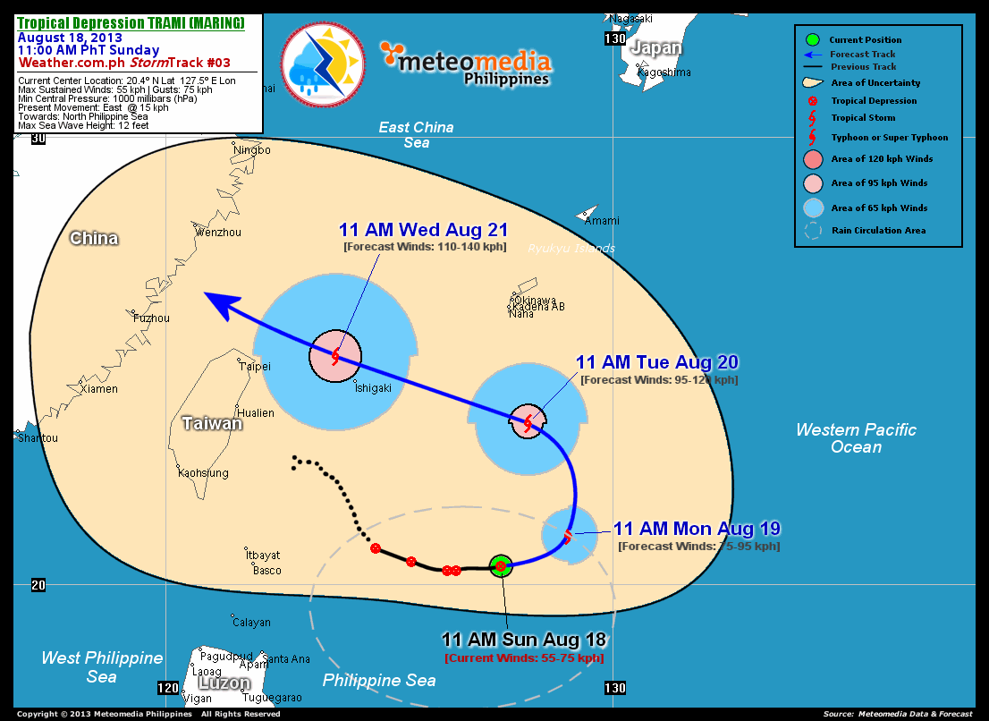
As of 11:00 am today, the center of TD Trami (Maring) was located over the North Philippine Sea...about 575 km east of Basco, Batanes or 680 km south of Okinawa, Japan...currently moving eastward with an increased forward speed of 15 km/hr.
Maximum Sustained Winds (1-min. avg) remain near 55 km/hr near the center with higher gusts. Trami (Maring) is a small-sized tropical cyclone with a diameter of 335 kilometers across. The 24-hour rainfall accumulation near the center of Trami (Maring) is estimated to be extreme (600 mm).
2-DAY FORECAST OUTLOOK*
TD Trami (Maring) is expected to move east to east-northeast for the next 24 hours...turning north to north-northwest by 48 hours. On the forecast track, the core of Trami (Maring) will remain over the warm open waters of the North Philippine Sea, just to the south of Okinawa thru Tuesday morning as the system undergoes a counter-clockwise turn.
Trami (Maring) is expected to gradually intensify through the next 24 to 48 hours...becoming a Tropical Storm (TS) later today or Monday. Advance Intensity Forecast (AIF) shows Trami (Maring) reaching a projected sustained winds of 95 km/hr on Tuesday morning.
The following is the summary of the 2-day forecast outlook and an extended 3-day forecast on this system:
 MONDAY MORNING: Becomes a TS as it begins its counter-clockwise turn across the North Philippine Sea...about 615 km south-southeast of Okinawa, Japan [11AM AUG 19: 21.1N 129.0E @ 75kph].
TUESDAY MORNING: Continues to gain strength...completes its counter-clockwise turn...moving west-northwest...about 325 km south of Okinawa, Japan [11AM AUG 20: 23.6N 128.1E @ 95kph].
WEDNESDAY MORNING: Still gaining strength...maintains its west-northwest as it passes over Yaeyama Islands...about 80 km northwest of Ishigakijima [11AM AUG 21: 25.1N 123.8E @ 110kph].
EFFECTS & HAZARDS SUMMARY
Below is the summary of the storm's parts and its hazards affecting specific areas. You can also view this image link for you to understand the parts.
RAINBANDS - where Tropical Depression Conditions with light, moderate to strong winds (30-62 kph) will be expected. Affected Areas: North Philippine Sea. (click here to know more about Rainbands). 24HR TOTAL RAINFALL ACCUMULATION - from 5 up to 200 mm (slight to heavy rainfall) can be expected along areas affected by the outer & inner rainbands (see above)...with isolated amounts of 201 to 600 mm (heavy to extreme) along areas to the south, west and near the center of Trami (Maring).
Important Note: Please keep in mind that the above forecast outlook, effects and hazards summary changes every 6 to 12 hrs!
CURRENT TECHNICAL INFORMATION
Time/Date: 11:00 AM PhT Sun Aug 18, 2013
Class/Name: TD Trami (Maring)
Location of Center: 20.4º N Lat 127.5º E Lon
Distance 1: 570 km SE of Ishigakijima
Distance 2: 575 km E of Basco, Batanes
Distance 3: 595 km ESE of Itbayat, Batanes
Distance 4: 680 km S of Okinawa, Japan
MaxWinds (1-min avg): 55 kph near the center
Peak Wind Gusts: 75 kph
Present Movement: E @ 15 kph
Towards: North Philippine Sea
24hr Rainfall Accum (near center): Extreme [600 mm]
Minimum Central Pressure: 1000 millibars (hPa)
Size (in Diameter): 335 km [Small]
Max Sea Wave Height (near center): 12 ft
T2K/WP StormTracks (for Public): GIF | Google Map (Flash)
CURRENT TRACKING MAP:
 _____________________________________________________________________________
__________________________________________________________________________________________________
CURRENT NOAA/MTSAT-2 INFRARED (IR) SATELLITE IMAGE:
 __________________________________________________________________________________________________
 >> To know the meteorological terminologies and acronyms used on this update visit the ff:
http://typhoon2000.ph/tcterm.htm
http://www.nhc.noaa.gov/aboutgloss.shtml
http://www.nhc.noaa.gov/acronyms.shtml
__________________________________________________________________________________________
For the complete details on TD TRAMI (MARING)...go visit our website @:
> http://www.typhoon2000.com
> http://www.maybagyo.com
<<<Typhoon2000.com Mobile >>>
Get the latest SMS Storm Alerts!
For more details: Text T2K TYPHOON to
2800 (Globe/TM) | Offline (Smart/TNT) | 2288 (Sun)
*Only P2.50 (Smart/Globe) / P2.00 (Sun) per msg received.
Click here on how to use this service (in PDF file)
Powered by: Synermaxx Corporation
Copyright © 2013 Typhoon2000.com All Rights Reserved
| Reply via web post | Reply to sender | Reply to group | Start a New Topic | Messages in this topic (1) |

No comments:
Post a Comment