
for Tuesday, 27 August 2013 [7:43 PM PhT]
WEATHER.COM.PH TROPICAL CYCLONE UPDATES
TROPICAL STORM KONG-REY (NANDO) UPDATE NUMBER 004
Issued: 6:00 PM PhT (10:00 GMT) Tuesday 27 August 2013
Next Update: 6:00 AM PhT (22:00 GMT) Wednesday 28 August 2013
Tropical Storm KONG-REY (NANDO) has gained more strength while moving northward across the North Philippine Sea. Its rainbands continues to affect Extreme Northern Luzon.
This storm will slightly induce the Southwest Monsoon (Hanging Habagat) - bringing mostly cloudy and breezy conditions with passing slight to moderate to sometimes heavy rains across Western Luzon including Metro Manila...becoming more frequent along Western Zambales, Pampanga, Tarlac, Pangasinan, La Union, Bataan, Lubang Island, Occidental Mindoro, Cavite, & Western Batangas tonight until Wednesday. The threat of Flash floods and landslides are likely in hazard-prone areas especially along river banks and mountain slopes of the affected areas. Residents are advised to take necessary precautions.
Residents and visitors along Taiwan, Yaeyama-Miyako Islands, and Okinawa-Ryukyu Islands should closely monitor the development of Kong-Rey (Nando).
Do not use this for life or death decisions. This update is intended for additional information purposes only. Kindly refer to your national weather agency for official warnings, advisories or bulletins.
CURRENT STORM ANALYSIS
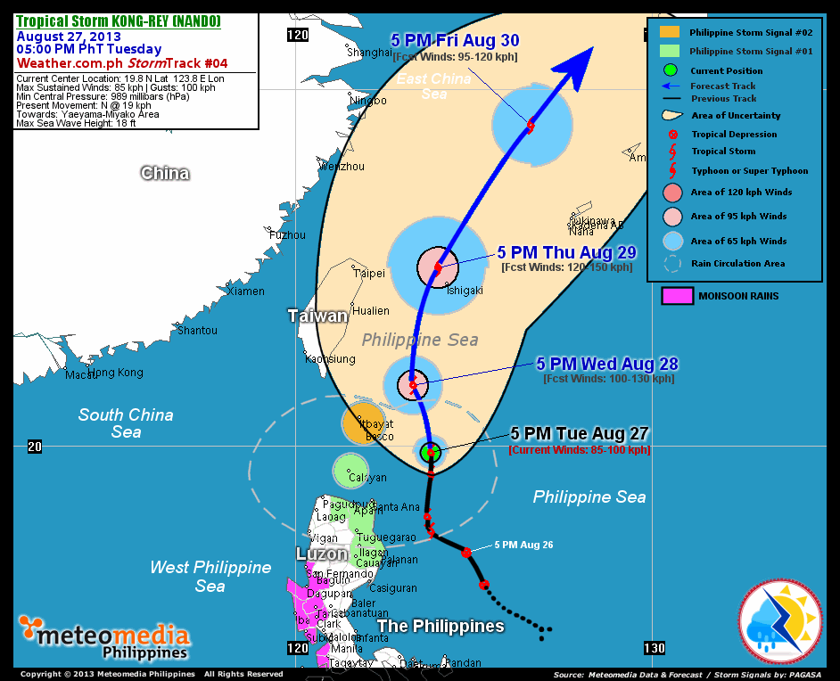
As of 5:00 pm today, the center of TS Kong-Rey (Nando) was located over the North Philippine Sea...about 220 km northeast of Santa Ana, Cagayan or 205 km east-southeast of Basco, Batanes...currently moving steadily northward with a decreased forward speed of 22 km/hr towards Yaeyama and Miyako Islands.
Maximum Sustained Winds (1-min. avg) have increased to 85 km/hr near the center with higher gusts. Tropical Storm Force Winds (63-100 km/hr) extend outward up to 55 kilometers from the center. Kong-Rey (Nando) remains an average-sized tropical cyclone with a diameter of 555 kilometers across. The 24-hour rainfall accumulation near the center of Kong-Rey (Nando) is estimated to be extreme (450 mm).
2-DAY FORECAST OUTLOOK*
TS Kong-Rey (Nando) is expected to move north-northwest to north during the next 24 hours, with a north to north-northeasterly turn through 48 hours. On the forecast track, the core of Kong-Rey (Nando) will be passing just to the east of Batanes Islands by early Wednesday morning...and will move out of the Philippine Area of Responsibility (PAR) or over the Yaeyama Island Chain by Thursday afternoon or evening.
TS Kong-Rey (Nando) will continue to intensify throughout the forecast period...and could become a Typhoon on Thursday. Advance Intensity Forecast (AIF) shows Kong-Rey (Nando) reaching its highest sustained winds of 120 km/hr by Thursday afternoon.
The following is the summary of the 2-day forecast outlook and an extended 3-day forecast on this system:
 WEDNESDAY AFTERNOON: Passing just to the northeast of Batanes Islands...continues to intensify...about 185 km northeast of Basco, Batanes [5PM AUG 28: 21.7N 123.3E @ 100kph].
THURSDAY AFTERNOON: Intensifies into a Typhoon while passing over the Yaeyama and Miyako Island Chain...exits the PAR...about 60 km north-northwest of Ishigakijima [5PM AUG 29: 25.0N 124.0E @ 120kph].
FRIDAY AFTERNOON: Accelerating across the East China Sea...weakens to a TS...about 300 km north-northwest of Okinawa, Japan [5PM AUG 30: 29.0N 126.6E @ 95kph].
*Please be reminded that the Forecast Outlook changes every 6 hours, and the Day 2 and 3 Forecast Tracks have an average error of 100 and 250 km respectively...while the wind speed forecast error, averages 35 kph per day. Therefore, a turn to the left or right of its future track and changes in its wind speed must be anticipated from time to time.
EFFECTS & HAZARDS SUMMARY
Below is the summary of the storm's parts and its hazards affecting specific areas. You can also view this image link for you to understand the parts.
INNER RAINBANDS - where Tropical Storm Conditions with Tropical Storm Force Winds (63-85 kph) will be expected. Affected Areas: Calayan-Babuyan-Batanes Group of Islands. OUTER RAINBANDS - where Tropical Depression Conditions with light, moderate to strong winds (30-62 kph) will be expected. Affected Areas: Rest of Northern Luzon (click here to know more about Rainbands). 24HR TOTAL RAINFALL ACCUMULATION - from 5 up to 200 mm (slight to heavy rainfall) can be expected along areas affected by the outer & inner rainbands (see above)...with isolated amounts of 201 to 450 mm (heavy to extreme) along areas to the south, west and near the center of Kong-Rey (Nando).
Important Note: Please keep in mind that the above forecast outlook, effects and hazards summary changes every 6 to 12 hrs!
CURRENT TECHNICAL INFORMATION
Time/Date: 5:00 PM PhT Tue Aug 27, 2013
Class/Name: TS Kong-Rey (Nando)
Location of Center: 19.8º N Lat 123.8º E Lon
Distance 1: 220 km NE of Santa Ana, Cagayan
Distance 2: 205 km ESE of Basco, Batanes
Distance 3: 245 km ENE of Calayan Island
Distance 4: 270 km NE of Aparri, Cagayan
Distance 5: 235 km SE of Itbayat, Batanes
Distance 6: 535 km S of Ishigakijima
Distance 7: 645 km NNE of Metro Manila
MaxWinds (1-min avg): 85 kph near the center
Peak Wind Gusts: 100 kph
Present Movement: North @ 19 kph
Towards: Yaeyama-Miyako Area
24hr Rainfall Accum (near center): Extreme [450 mm]
Minimum Central Pressure: 989 millibars (hPa)
Size (in Diameter): 555 km [Average]
Max Sea Wave Height (near center): 18 feet
T2K/WP StormTracks (for Public): GIF | Google Map (Flash)
CURRENT TRACKING MAP:
 _____________________________________________________________________________
__________________________________________________________________________________________________
CURRENT NOAA/MTSAT-2 INFRARED (IR) SATELLITE IMAGE:

__________________________________________________________________________________________________
>> To know the meteorological terminologies and acronyms used on this update visit the ff:
http://typhoon2000.ph/tcterm.htm
http://www.nhc.noaa.gov/aboutgloss.shtml
http://www.nhc.noaa.gov/acronyms.shtml
__________________________________________________________________________________________
For the complete details on TS KONG-REY (NANDO)...go visit our website @:
> http://www.typhoon2000.com
> http://www.maybagyo.com
<<<Typhoon2000.com Mobile >>>
Get the latest SMS Storm Alerts!
For more details: Text T2K TYPHOON to
2800 (Globe/TM) | Offline (Smart/TNT) | 2288 (Sun)
*Only P2.50 (Smart/Globe) / P2.00 (Sun) per msg received.
Click here on how to use this service (in PDF file)
Powered by: Synermaxx Corporation
Copyright © 2013 Typhoon2000.com All Rights Reserved
| Reply via web post | Reply to sender | Reply to group | Start a New Topic | Messages in this topic (1) |

No comments:
Post a Comment