
for Tuesday, 06 August 2013 [7:55 PM PhT]
WEATHER.COM.PH TROPICAL CYCLONE UPDATES
TROPICAL STORM MANGKHUT (KIKO) UPDATE NUMBER 003
Issued: 7:00 AM PhT (23:00 GMT) Wednesday 07 August 2013
Next Update: 7:00 PM PhT (11:00 GMT) Wednesday 07 August 2013
10W (KIKO) becomes a Tropical Storm (TS) and is now internationally named "MANGKHUT" - a Thai word for the fruit Mangosteen...slows down while passing in between Hainan Island and Central Vietnam...threat to Northern Vietnam increases. Its thick southwestern rainbands are bringing moderate to heavy rains across Central Vietnam and some portions of Eastern Laos.
Residents and visitors along Northern Vietnam should closely monitor the development of Mangkhut (Kiko).
Do not use this for life or death decisions. This update is intended for additional information purposes only. Kindly refer to your national weather agency for official warnings, advisories or bulletins.
CURRENT STORM ANALYSIS
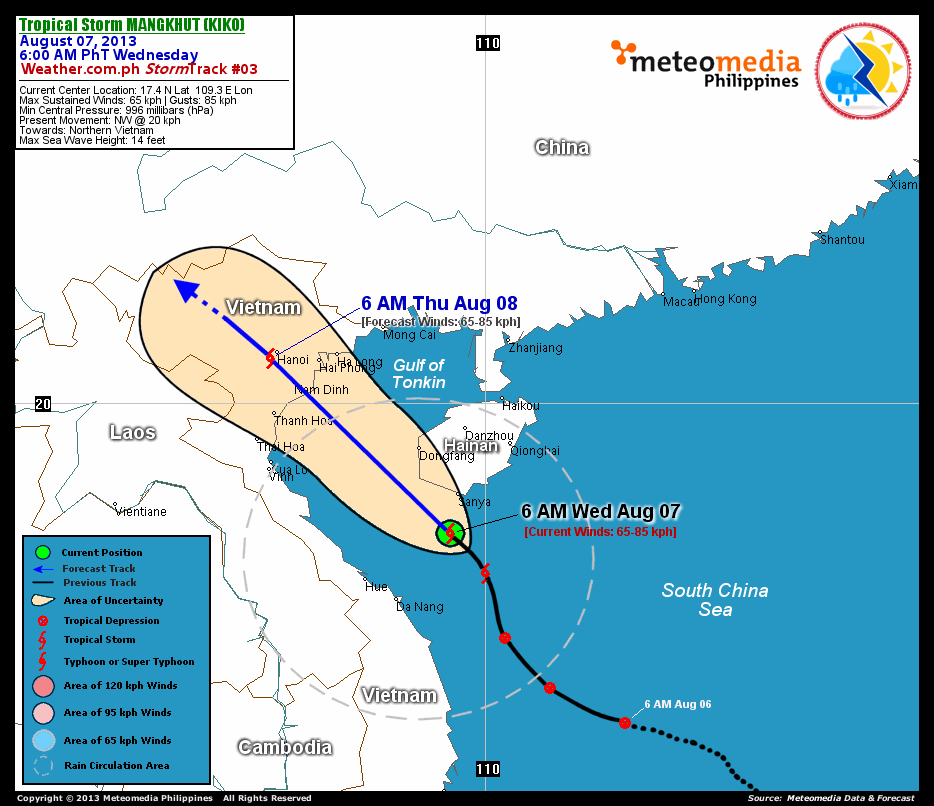
As of 6:00 am today, the center of TS Mangkhut (Kiko) was located over the South China Sea, near the southern part of Hainan Island...about 90 km south of Sanya, Hainan or 465 km southeast of Nam Dinh, Vietnam...currently moving northwest with a decreased forward speed of 20 km/hr towards Northern Vietnam.
Maximum Sustained Winds (1-min. avg) have increased to near 65 km/hr near the center with higher gusts. Mangkhut (Kiko) is an average-sized tropical cyclone with a diameter of 445 kilometers across. The 24-hour rainfall accumulation near the center of Mangkhut (Kiko) is estimated to be heavy (300 mm).
1-DAY FORECAST OUTLOOK*
TS Mangkhut (Kiko) is expected to continue moving northwestward throughout the forecast period. On the forecast track, the core of Mangkhut (Kiko) will make landfall over Northern Vietnam (very near Nam Dinh City) on or before midnight on Thursday...and will traverse Northern Vietnam throughout Thursday.
Mangkhut (Kiko) is expected to continue gaining strength within the next 12 hours as it moves closer to Northern Vietnam. Advance Intensity Forecast (AIF) shows the storm briefly reaching peak sustained winds of 75 km/hr this afternoon or evening...then starts to weaken and dissipate after making landfall on Thursday.
The following is the summary of the 1-day forecast outlook on this system:
 THURSDAY MORNING: Over Northern Vietnam...weakens into a minimal TS...dissipating over land...about 15 km southwest of Hanoi, Vietnam [6AM AUGUST 08: 20.9N 105.7E @ 65kph].
*Please be reminded that the Forecast Outlook changes every 6 hours, and the Day 2 and 3 Forecast Tracks have an average error of 100 and 250 km respectively...while the wind speed forecast error, averages 35 kph per day. Therefore, a turn to the left or right of its future track and changes in its wind speed must be anticipated from time to time.
EFFECTS & HAZARDS SUMMARY
Below is the summary of the storm's parts and its hazards affecting specific areas. You can also view this image link for you to understand the parts.
INNER RAINBANDS - where Tropical Storm Conditions with Tropical Storm Force Winds (63-85 kph) will be expected. Affected Areas: Offshore of Southern Hainan and the Southern seas of the Gulf of Tonkin. OUTER RAINBANDS - where Tropical Depression Conditions with light, moderate to strong winds (30-62 kph) will be expected. Affected Areas: Central Vietnam and Southern Hainan. (click here to know more about Rainbands) 24HR TOTAL RAINFALL ACCUMULATION - from 5 up to 100 mm (slight to heavy rainfall) can be expected along areas affected by the outer & inner rainbands (see above)...with isolated amounts of 101 to 300 mm (heavy) along areas to the south, west and near the center of Mangkhut (Kiko).
Important Note: Please keep in mind that the above forecast outlook, effects and hazards summary changes every 6 to 12 hrs!
CURRENT TECHNICAL INFORMATION
Time/Date: 6:00 AM PhT Wed Aug 07, 2013
Class/Name: TS Mangkhut (Kiko)
Location of Center: 17.4º N Lat 109.3º E Lon
Distance 1: 90 km S of Sanya, Hainan Is.
Distance 2: 185 km NNE of Da Nang, Vietnam
Distance 3: 200 km SSE of Dongfang, Hainan Is.
Distance 4: 205 km NE of Hue, Vietnam
Distance 5: 465 km SE of Nam Dinh, Vietnam
MaxWinds (1-min avg):65 kph near the center
Peak Wind Gusts: 85 kph
Present Movement: NW @ 20 kph
Towards: Northern Vietnam
CPA [ETA] to Northern Vietnam: Tonight [11PM-1AM PhT]
24hr Rainfall Accum (near center): Heavy [300 mm]
Minimum Central Pressure: 996 millibars (hPa)
Size (in Diameter): 445 km [Average]
Max Sea Wave Height (near center): 14 feet
Possible Storm Surge Height: 1-3 ft (0.3-0.9 m)
T2K/WP StormTracks (for Public): GIF | Google Map (Flash)
CURRENT TRACKING MAP:
 _____________________________________________________________________________
__________________________________________________________________________________________________
CURRENT NOAA/MTSAT-2 INFRARED (IR) SATELLITE IMAGE:

__________________________________________________________________________________________________
>> To know the meteorological terminologies and acronyms used on this update visit the ff:
http://typhoon2000.ph/tcterm.htm
http://www.nhc.noaa.gov/aboutgloss.shtml
http://www.nhc.noaa.gov/acronyms.shtml
__________________________________________________________________________________________
For the complete details on TS MANGKHUT (KIKO)...go visit our website @:
> http://www.typhoon2000.com
> http://www.maybagyo.com
<<<Typhoon2000.com Mobile >>>
Get the latest SMS Storm Alerts!
For more details: Text T2K TYPHOON to
2800 (Globe/TM) | Offline (Smart/TNT) | 2288 (Sun)
*Only P2.50 (Smart/Globe) / P2.00 (Sun) per msg received.
Click here on how to use this service (in PDF file)
Powered by: Synermaxx Corporation
Copyright © 2013 Typhoon2000.com All Rights Reserved
| Reply via web post | Reply to sender | Reply to group | Start a New Topic | Messages in this topic (1) |

No comments:
Post a Comment