
for Monday, 26 August 2013 [7:42 PM PhT]
WEATHER.COM.PH TROPICAL CYCLONE UPDATES
TROPICAL DEPRESSION KONG-REY (NANDO) UPDATE NUMBER 001
Issued: 6:00 PM PhT (10:00 GMT) Monday 26 August 2013
Next Update: 6:00 AM PhT (22:00 GMT) Tuesday 27 August 2013
The strong and broad Tropical Disturbance (LPA 91W) [NANDO] over the Central Philippine Sea, east of Aurora has reached Tropical Depression threshold this morning...and is now internationally known as KONG-REY - named after a mountain in Cambodia/a pretty girl in Khmer legend. This system has been moving towards the Batanes-Taiwan Area and will once again induce the Southwest Monsoon across the western sections of Luzon and Visayas.
This depression will induce the Southwest Monsoon (Hanging Habagat) - bringing cloudy and windy conditions with "on-and-off" slight to moderate to sometimes heavy rains across the western sections of Luzon & Visayas including Bicol Region...becoming more frequent along MiMaRoPa, CaLaBaRZon, Bataan and Metro Manila tonight and Tuesday. The threat of Flash floods and landslides are likely in hazard-prone areas especially along river banks and mountain slopes of the affected areas.
Residents and visitors along Extreme Northern Luzon, Taiwan, Yaeyama-Miyako Islands, and Okinawa-Ryukyu Islands should closely monitor the development of Kong-Rey (Nando).
Do not use this for life or death decisions. This update is intended for additional information purposes only. Kindly refer to your national weather agency for official warnings, advisories or bulletins.
CURRENT STORM ANALYSIS
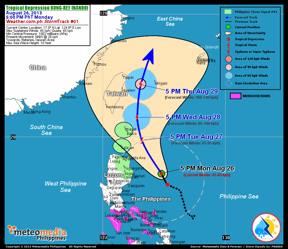
As of 5:00 pm today, the center of TD Kong-Rey (Nando) was located near Central Philippine Sea...about 255 km east of Palanan, Isabela or 300 km east-northeast of Casiguran, Aurora...currently moving north-northwest with a forward speed of 26 km/hr towards Batanes-Taiwan Area.
Maximum Sustained Winds (1-min. avg) are at 45 km/hr near the center with higher gusts. . Kong-Rey (Nando) is an aversge-sized tropical cyclone with a diameter of 445 kilometers across. The 24-hour rainfall accumulation near the center of Kong-Rey (Nando) is estimated to be extreme (400 mm).
2-DAY FORECAST OUTLOOK*
TD Kong-Rey (Nando) is expected to move north-northwest during the next 24 hours, with a northerly turn through 48 hours. On the forecast track, the core of Kong-Rey (Nando) will be passing close to the east and northeast of Batanes Islands on Wednesday.
TD Kong-Rey (Nando) will slowly intensify within the next 12 to 24 hours...and could become a Tropical Storm (TS) on Tuesday morning or afternoon. Advance Intensity Forecast (AIF) shows that Kong-Rey (Nando) could reach its highest sustained winds of 85 km/hr by Wednesday afternoon.
The following is the summary of the 2-day forecast outlook and an extended 3-day forecast on this system:
 TUESDAY AFTERNOON: Passing close to east of Calayan and Batanes Islands...strengthens into a TS...about 155 km southeast of Basco, Batanes [5PM AUG 27: 19.7N 123.2E @ 65kph].
WEDNESDAY AFTERNOON: Intensifies further while passing east of Bashi Channel...approaching Yaeyama Islands...about 150 km north-northeast of Basco, Batanes [5PM AUG 28: 21.6N 122.8E @ 85kph].
THURSDAY AFTERNOON: Over Yaeyama Islands...strengthens to near-Typhoon intensity...about 170 km east-southeast of Taipei, Taiwan [5PM AUG 29: 24.3N 123.1E @ 100kph].
*Please be reminded that the Forecast Outlook changes every 6 hours, and the Day 2 and 3 Forecast Tracks have an average error of 100 and 250 km respectively...while the wind speed forecast error, averages 35 kph per day. Therefore, a turn to the left or right of its future track and changes in its wind speed must be anticipated from time to time.
EFFECTS & HAZARDS SUMMARY
Below is the summary of the storm's parts and its hazards affecting specific areas. You can also view this image link for you to understand the parts.
DEVELOPING RAINBANDS - where Tropical Depression Conditions with light, moderate to strong winds (30-62 kph) will be expected. Affected Areas: Cagayan, Isabela, Aurora, and Northern Quezon including Polillo Islands (click here to know more about Rainbands). 24HR TOTAL RAINFALL ACCUMULATION - from 5 up to 200 mm (slight to heavy rainfall) can be expected along areas affected by the outer & inner rainbands (see above)...with isolated amounts of 201 to 400 mm (heavy to extreme) along areas to the south, west and near the center of Kong-Rey (Nando).
Important Note: Please keep in mind that the above forecast outlook, effects and hazards summary changes every 6 to 12 hrs!
CURRENT TECHNICAL INFORMATION
Time/Date: 5:00 PM PhT Mon Aug 26, 2013
Class/Name: TD Kong-Rey (Nando)
Location of Center: 17.0º N Lat 124.8º E Lon
Distance 1: 255 km E of Palanan, Isabela
Distance 2: 300 km ENE of Casiguran, Aurora
Distance 3: 320 km ESE of Ilagan City
Distance 4: 320 km SE of Santa Ana, Cagayan
Distance 5: 335 km ESE of Tuguegarao City
Distance 6: 475 km NE of Metro Manila
Distance 7: 490 km SSE of Basco, Batanes
MaxWinds (1-min avg): 45 kph near the center
Peak Wind Gusts: 65 kph
Present Movement: NNW @ 26 kph
Towards: Batanes-Taiwan Area
24hr Rainfall Accum (near center): Extreme [400 mm]
Minimum Central Pressure: 1002 millibars (hPa)
Size (in Diameter): 445 km [Average]
Max Sea Wave Height (near center): 10 feet
T2K/WP StormTracks (for Public): GIF | Google Map (Flash)
CURRENT TRACKING MAP:
 _____________________________________________________________________________
__________________________________________________________________________________________________
CURRENT NOAA/MTSAT-2 INFRARED (IR) SATELLITE IMAGE:

__________________________________________________________________________________________________
>> To know the meteorological terminologies and acronyms used on this update visit the ff:
http://typhoon2000.ph/tcterm.htm
http://www.nhc.noaa.gov/aboutgloss.shtml
http://www.nhc.noaa.gov/acronyms.shtml
__________________________________________________________________________________________
For the complete details on TD KONG-REY (NANDO)...go visit our website @:
> http://www.typhoon2000.com
> http://www.maybagyo.com
<<<Typhoon2000.com Mobile >>>
Get the latest SMS Storm Alerts!
For more details: Text T2K TYPHOON to
2800 (Globe/TM) | Offline (Smart/TNT) | 2288 (Sun)
*Only P2.50 (Smart/Globe) / P2.00 (Sun) per msg received.
Click here on how to use this service (in PDF file)
Powered by: Synermaxx Corporation
Copyright © 2013 Typhoon2000.com All Rights Reserved
| Reply via web post | Reply to sender | Reply to group | Start a New Topic | Messages in this topic (1) |

No comments:
Post a Comment