
for Thursday, 29 August 2013 [7:46 AM PhT]
WEATHER.COM.PH TROPICAL CYCLONE UPDATES
TROPICAL STORM KONG-REY (NANDO) UPDATE NUMBER 008
Issued: 6:00 AM PhT (22:00 GMT) Thursday 29 August 2013
Next Update: 12:00 NN PhT (04:00 GMT) Thursday 29 August 2013
Tropical Storm KONG-REY (NANDO) has maintained its northerly track while slightly gaining strength near the east coast of Taiwan. Most of its rainbands are covering almost the entire country of Taiwan where heavy rains with gusty winds will be expected.
This storm will slightly induce the Southwest Monsoon (Hanging Habagat) - bringing mostly cloudy and breezy conditions with occasional slight to moderate to sometimes heavy rains or thunderstorms across the Batanes-Calayan-Babuyan Island Group. The threat of flash floods and landslides are likely in hazard-prone areas especially along river banks and mountain slopes of the affected areas. Residents are advised to take necessary precautions.
Residents and visitors along Taiwan, Yaeyama-Miyako Islands, and Okinawa-Ryukyu Islands should closely monitor the development of Kong-Rey (Nando).
Do not use this for life or death decisions. This update is intended for additional information purposes only. Kindly refer to your national weather agency for official warnings, advisories or bulletins.
CURRENT STORM ANALYSIS
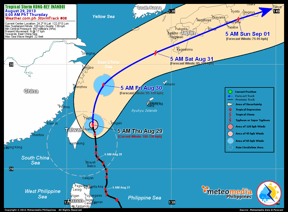
As of 5:00 am today, the center of TS Kong-Rey (Nando) was located near the east coast of Taiwan...about 95 km east-northeast of Hualien, Taiwan or 125 km southeast of Taipei, Taiwan...currently moving northward with an increased forward speed of 17 km/hr towards the East China Sea.
Maximum Sustained Winds (1-min. avg) have increased to 100 km/hr near the center with higher gusts. Tropical Storm Force Winds (63-117 km/hr) extend outward up to 120 kilometers from the center. Kong-Rey (Nando) remains an average-sized tropical cyclone with a diameter of 555 kilometers across. The 24-hour rainfall accumulation near the center of Kong-Rey (Nando) is estimated to be extreme (400 mm).
2-DAY FORECAST OUTLOOK*
TS Kong-Rey (Nando) is expected to continue moving north for the next 12 hours, turning north-northeast with an increase in forward speed through 24 hours. Throughout the 48-hr. forecast period, the storm will accelerate rapidly towards the east-northeast. On the forecast track, the core of Kong-Rey (Nando) will be passing near the northeastern coast of Taiwan this morning...and will move out of the Philippine Area of Responsibility (PAR) on or after noontime. The storm will move across the East China Sea later tonight through Friday morning...and will be approaching the western shores of Kyushu, Japan on Saturday morning.
TS Kong-Rey (Nando) may have reached its peak intensity and could start losing strength during the next 48 hours. It will then be transforming into an Extratropical (Mid-latitude) during that timeframe. Advance Intensity Forecast (AIF) shows Kong-Rey (Nando) decreasing its 1-minute sustained winds to just 85 km/hr on Saturday morning.
The following is the summary of the 2-day forecast outlook and an extended 3-day forecast on this system:
 FRIDAY MORNING: Already outside of PAR...weakens slightly as it moves across the East China Sea...about 285 km southeast of Ningbo, China [5AM AUG 30: 28.0N 123.5E @ 95kph].
SATURDAY MORNING: Becomes an Extratropical Cyclone as it accelerates rapidly towards Western Kyushu...about 200 km west-southwest of Kagoshima, Japan [5AM AUG 31: 31.1N 128.5E @ 85kph].
SUNDAY MORNING: Continues to weaken as it moves faster across Southern Honshu...remains an Extratropical Cyclone...about 110 km southwest of Nagoya, Japan [5AM SEP 01: 34.3N 136.4E @ 75kph].
*Please be reminded that the Forecast Outlook changes every 6 hours, and the Day 2 and 3 Forecast Tracks have an average error of 100 and 250 km respectively...while the wind speed forecast error, averages 35 kph per day. Therefore, a turn to the left or right of its future track and changes in its wind speed must be anticipated from time to time.
EFFECTS & HAZARDS SUMMARY
Below is the summary of the storm's parts and its hazards affecting specific areas. You can also view this image link for you to understand the parts.
INNER RAINBANDS - where Tropical Storm Conditions with Tropical Storm Force Winds (63-85 kph) will be expected. Affected Areas: Eastern part of East Taiwan Sea and the Eastern Coastal Areas of Taiwan. OUTER RAINBANDS - where Tropical Depression Conditions with light, moderate to strong winds (30-62 kph) will be expected. Affected Areas: Rest of Taiwan, Taiwan Strait and the Batanes Group of Islands. (click here to know more about Rainbands). 24HR TOTAL RAINFALL ACCUMULATION - from 5 up to 200 mm (slight to heavy rainfall) can be expected along areas affected by the outer & inner rainbands (see above)...with isolated amounts of 201 to 400 mm (heavy to extreme) along areas to the west, south and near the center of Kong-Rey (Nando).
Important Note: Please keep in mind that the above forecast outlook, effects and hazards summary changes every 6 to 12 hrs!
CURRENT TECHNICAL INFORMATION
Time/Date: 5:00 AM PhT Thu Aug 29, 2013
Class/Name: TS Kong-Rey (Nando)
Location of Center: 24.2º N Lat 122.5º E Lon
Distance 1: 95 km NNE of Hualien, Taiwan
Distance 2: 125 km SE of Taipei, Taiwan
Distance 3: 175 km WSW of Ishigakijima
Distance 4: 385 km NNE of Itbayat, Batanes
Distance 5: 415 km NNE of Basco, Batanes
MaxWinds (1-min avg): 100 kph near the center
Peak Wind Gusts: 130 kph
Present Movement: N @ 17 kph
Towards: East China Sea
24hr Rainfall Accum (near center): Extreme [400 mm]
Minimum Central Pressure: 982 millibars (hPa)
Size (in Diameter): 555 km [Average]
Max Sea Wave Height (near center): 20 feet
T2K/WP StormTracks (for Public): GIF | Google Map (Flash)
CURRENT TRACKING MAP:
 _____________________________________________________________________________
__________________________________________________________________________________________________
CURRENT NOAA/MTSAT-2 INFRARED (IR) SATELLITE IMAGE:

__________________________________________________________________________________________________
>> To know the meteorological terminologies and acronyms used on this update visit the ff:
http://typhoon2000.ph/tcterm.htm
http://www.nhc.noaa.gov/aboutgloss.shtml
http://www.nhc.noaa.gov/acronyms.shtml
__________________________________________________________________________________________
For the complete details on TS KONG-REY (NANDO)...go visit our website @:
> http://www.typhoon2000.com
> http://www.maybagyo.com
<<<Typhoon2000.com Mobile >>>
Get the latest SMS Storm Alerts!
For more details: Text T2K TYPHOON to
2800 (Globe/TM) | Offline (Smart/TNT) | 2288 (Sun)
*Only P2.50 (Smart/Globe) / P2.00 (Sun) per msg received.
Click here on how to use this service (in PDF file)
Powered by: Synermaxx Corporation
Copyright © 2013 Typhoon2000.com All Rights Reserved
| Reply via web post | Reply to sender | Reply to group | Start a New Topic | Messages in this topic (1) |

No comments:
Post a Comment