
for Wednesday, 09 July 2014 [9:17 PM PhT]
WEATHER.COM.PH TROPICAL CYCLONE UPDATES
TYPHOON NEOGURI (FLORITA) UPDATE NUMBER 009
Issued at: 6:30 PM PhT (10:30 GMT) Wednesday 09 July 2014
Next Update: 6:00 AM PhT (22:00 GMT) Thursday 10 July 2014
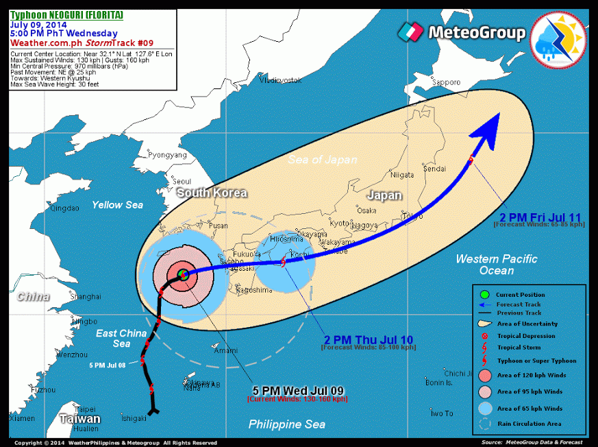
Typhoon NEOGURI (FLORITA) has weakened further as it heads towards Western Kyushu.
This typhoon will continue to enhance the Southwest Monsoon (Hanging Habagat) - bringing cloudy conditions w/ occasional light to moderate rains and gusty winds (not exceeding 40 kph) across MiMaRoPa, Western Visayas and portions of Western Luzon...becoming more frequent along Calamian-Cuyo-Pamalican Group of Islands, Western Panay incl. Boracay, Mindoro Occidental, and Western Zambales tonight through Thursday. The threat of flash floods and landslides are likely in hazard-prone areas especially along river banks and mountain slopes of the affected areas during the occurrence of severe thunderstorms. Residents are advised to take necessary precautions.
Residents and visitors along Southern Japan should closely monitor the development of TY Neoguri (Florita).
Information based on data collected by WeatherPhilippines Foundation, Inc. shall not be taken as official data. Weather information broadcasted and distributed by PAGASA remains as official data. WeatherPhilippines shall not be responsible for the private use and reliance of its weather information.
CYCLONE HAZARDS AFFECTING LAND
Below are the regions or places in the Philippines with possible effects caused by the current tropical cyclone.
 None.
None.
CURRENT CYCLONE INFORMATION
As of 5:00 PM PhT today...0900 GMT.
Location: Over the northeastern part of the East China Sea (near 32.1N 127.6E)
About: 240 km west-southwest of Nagasaki, Japan
Maximum Sustained Winds (1-min avg): 130 kph near the center...Gustiness: 160 kph
24 hr. Rain Accumulation (near and south of the eye): 100 to 400 mm [Heavy to Extreme]
Size (in diameter): 1,140 km (Average)
Past Movement: Northeast @ 25 kph
Forecast Movement: East-Northeast @ 25 kph
Towards: Western Kyushu
2-DAY FORECAST OUTLOOK*
TY Neoguri (Florita) is expected to move generally east-northeast during the next 24 to 36 hours...and will slightly turn back to the northeast with a much faster forward speed through 48 hours. On the forecast track, the typhoon will make landfall over the central part of Western Kyushu late tonight crossing the island and will traverse Southern Shikoku, Japan by Thursday afternoon. It will then be passing along the southern shores of Honshu, Japan on Thursday evening through Friday morning. By Friday afternoon, Neoguri will be over the Northwest Pacific Ocean, about 175 kilometers to the east of the Northeastern Coast of Honshu, Japan.
Neoguri (Florita) will continue to rapidly lose strength through the next 24 hours and will be dowgraded to a Tropical Storm (TS) while moving along the Southern Coasts of Japan due to unfavorable atmospheric conditions and the effect of Japanese terrain which will also lead Neoguri to Extratropical transition. Advance Intensity Forecast (AIF) shows its 1-minute maximum sustained winds decreasing to 65 kph by Friday afternoon.
The following is the summary of the 2-day forecast outlook on this system:
THURSDAY AFTERNOON: Traverses Central Kyushu and Southern Shikoku...weakens to Tropical Storm...about 75 km SW of Kochi, Japan [2PM JUL 10: 32.9N 133.2E @ 85kph]. FRIDAY AFTERNOON: Rapidly accelerates towards the east-northeast and northeast while traversing the southern shoreline of Honshu...becoming an Extratropical Cyclone (aka. Middle-latitude Cyclone)...about 230 km E of Sendai, Japan [2PM JUL 11: 38.5N 143.5E @ 65kph].
*Please be reminded that the Forecast Outlook changes every 6 hours, and the Day 2 and 3 Forecast Track has an average error of 100 and 250 km respectively...while the wind speed forecast error, averages 35 kph per day. Therefore, a turn to the left or right of its future track and changes in its wind speed must be anticipated from time to time.
Important Note: Please keep in mind that the above hazards summary and forecast outlook changes every 6 to 12 hrs!
ADDITIONAL DISTANCES & TECHNICAL INFO
Time/Date: 5:00 PM PhT Wed Jul 09, 2014
Class/Name: TY Neoguri (Florita)
Minimum Central Pressure: 970 millibars (hPa)
Location of Eye: Near 32.1º N Lat 127.6º E Lon
Distance 1: 465 km NW of Amami, Japan
Distance 2: 3635 km N of Okinawa, Japan
Distance 3: 280 km WNW of Kasgoshima, Japan
Distance 4: 985 km NE of Taipei, Taiwan
Distance 5: 1,405 km NNE of Basco, Batanes
Saffir-Simpson Hurricane Scale: Category 1
T2K/WP StormTrack (for Public): GIF
CURRENT TRACKING MAP:
_____________________________________________________________________________

__________________________________________________________________________________________________
CURRENT NOAA/MTSAT-2 INFRARED (IR) SATELLITE IMAGE:

__________________________________________________________________________________________________
>> To know the meteorological terminologies and acronyms used on this update visit the ff:
http://typhoon2000.ph/tcterm.htm
http://www.nhc.noaa.gov/aboutgloss.shtml
http://www.nhc.noaa.gov/acronyms.shtml
__________________________________________________________________________________________
For the complete details on TY NEOGURI (FLORITA)...go visit our website @:
> http://www.typhoon2000.com
> http://www.maybagyo.com
Copyright © 2014 Typhoon2000.com All Rights Reserved
Posted by: "Typhoon2000.com (Michael V. Padua)" <T2Kstormupdates@gmail.com>
| Reply via web post | • | Reply to sender | • | Reply to group | • | Start a New Topic | • | Messages in this topic (1) |

No comments:
Post a Comment