
for Saturday, 12 July 2014 [7:10 PM PhT]
WEATHER.COM.PH TROPICAL CYCLONE UPDATES
TROPICAL STORM RAMMASUN (GLENDA) UPDATE NUMBER 004
Issued at: 7:45 AM PhT (23:45 GMT) Monday 14 July 2014
Next Update: 12:00 PM PhT (04:00 GMT) Monday 14 July 2014
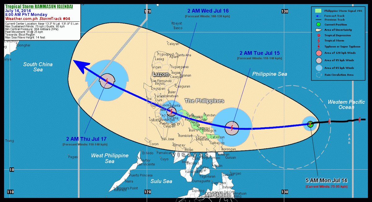
RAMMASUN (GLENDA) entered the Philippine Area of Responsibility (PAR) early last night...and intensified slightly as it continues to track swiftly westward threatening the Bicol Region and Northern Samar. The potential landfall area of this storm shall be over Camarines Sur on Tuesday afternoon, July 15.
Residents and visitors along Luzon and Northern Visayas particularly the eastern shorelines should closely monitor the development of TS Rammasun (Glenda).
Information based on data collected by WeatherPhilippines Foundation, Inc. shall not be taken as official data. Weather information broadcasted and distributed by PAGASA remains as official data. WeatherPhilippines shall not be responsible for the private use and reliance of its weather information.
CYCLONE HAZARDS AFFECTING LAND
Below are the regions or places in the Philippines that could be affected by the current tropical cyclone.
 BICOL REGION and NORTHERN SAMAR: Heavy rains of 50 mm or more are likely to occur beginning Tuesday morning until Wednesday morning...with Tropical Storm Force Winds of 75 kph up to storm intensity near the center, Residents living along the hazard-prone areas are advised to seek shelter and take precautionary measures against flashfloods and landslides.
CURRENT CYCLONE INFORMATION
As of 5:00 AM PhT today...2100 GMT.
Location: Over the eastern part of the Philippine Sea (near 13.3N 131.9E)
About: 835 km east of Virac, Catanduanes...or 890 km east of Legazpi City, Albay
Maximum Sustained Winds (1-min avg): 75 kph near the center...Gustiness: 95 kph
24 hr. Rain Accumulation (near the center): 100 to 300 mm [Heavy to Extreme]
Size (in diameter): 370 km (Midget)
Area of Damaging Winds (95 kph or more): None
Past Movement: West @ 26 kph
Forecast Movement: West @ 26 kph
Towards: Bicol Region
3-DAY FORECAST OUTLOOK*
TS Rammasun (Glenda) is expected to continue moving generally westward during the next 24 hours...and will turn west-northwestward with a slight decrease in its forward speed by 48 through 72 hours. On the forecast track, the storm will traverse the central portion of the Philippine Sea today...making landfall over Camarines Sur by Tuesday afternoon...and passing over Metro Manila by Wednesday morning. Rammasun (Glenda) will be over the West Philippine Sea by Thursday early morning.
Rammasun will continue to slowly intensify during the next 24 hours. It will then weaken slightly by 48 hours after making landfall, and will regain strength as it moves across the West Philippine Sea. Advance Intensity Forecast (AIF) shows its 1-minute maximum sustained winds increasing to 110 kph by Tuesday early morning.
The following is the summary of the 3-day forecast outlook on this system:
TUESDAY EARLY MORNING: Strengthens further as it moves westward across the western part of the Central Philippine Sea...approaching Bicol Region...about 225 km East-Southeast of Virac, Catanduanes [2AM JUL 15: 13.0N 126.2E @ 110kph]. WEDNESDAY EARLY MORNING: Weakens slightly as it interacts with the mountain ranges of Camarines Provinces...over the central-eastern coast of Quezon...about 95 km Southeast of Metro Manila [2AM JUL 16: 14.2N 121.8E @ 100kph]. THURSDAY EARLY MORNING: Over the West Philippine Sea as it regains strength...about 335 km West-Northwest of Iba, Zambales [2AM JUL 17: 16.4N 117.1E @ 110kph].
*Please be reminded that the Forecast Outlook changes every 6 hours, and the Day 2 and 3 Forecast Track has an average error of 100 and 250 km respectively...while the wind speed forecast error, averages 35 kph per day. Therefore, a turn to the left or right of its future track and changes in its wind speed must be anticipated from time to time.
Important Note: Please keep in mind that the above hazards summary and forecast outlook changes every 6 to 12 hrs!
ADDITIONAL DISTANCES & TECHNICAL INFO
Time/Date: 5:00 AM PhT Mon Jul 14, 2014
Class/Name: TS Rammasun (Glenda)
Minimum Central Pressure: 994 millibars (hPa)
Location of Center: Near 13.3º N Lat 131.9º E Lon
Distance 1: 795 km ENE of Catarman, Northern Samar
Distance 2: 835 km E of Virac, Catanduanes
Distance 3: 890 km E of Legazpi City
Distance 4: 950 km E of Metro Naga
Distance 5: 1185 km E of Metro Manila
T2K/WP StormTrack (for Public): GIF
CURRENT TRACKING MAP:
_____________________________________________________________________________

__________________________________________________________________________________________________
CURRENT NOAA/MTSAT-2 INFRARED (IR) SATELLITE IMAGE:

__________________________________________________________________________________________________
>> To know the meteorological terminologies and acronyms used on this update visit the ff:
http://typhoon2000.ph/tcterm.htm
http://www.nhc.noaa.gov/aboutgloss.shtml
http://www.nhc.noaa.gov/acronyms.shtml
__________________________________________________________________________________________
For the complete details on TS RAMMASUN (GLENDA)...go visit our website @:
> http://www.typhoon2000.com
> http://www.maybagyo.com
Copyright © 2014 Typhoon2000.com All Rights Reserved
Posted by: "Typhoon2000.com (Michael V. Padua)" <T2Kstormupdates@gmail.com>
| Reply via web post | • | Reply to sender | • | Reply to group | • | Start a New Topic | • | Messages in this topic (1) |

No comments:
Post a Comment