
for Sunday, 13 July 2014 [8:11 AM PhT]
WEATHER.COM.PH TROPICAL CYCLONE UPDATES
TROPICAL STORM RAMMASUN UPDATE NUMBER 002
Issued at: 6:30 AM PhT (22:30 GMT) Sunday 13 July 2014
Next Update: 6:00 PM PhT (10:00 GMT) Sunday 13 July 2014
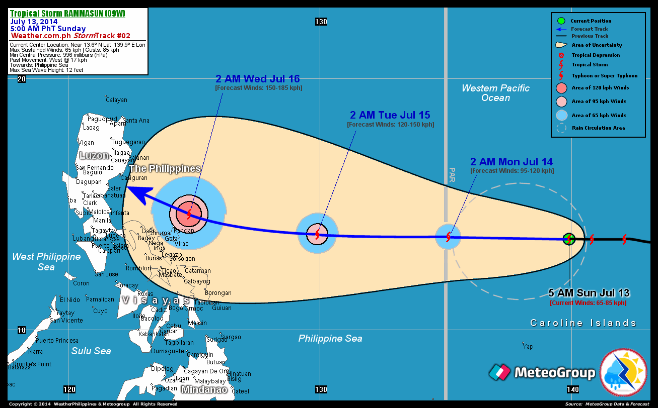
Tropical Storm (TS) RAMMASUN has maintained its westerly track and strength while heading towards the Philippine Sea...expected to enter the Philippine Area of Responsibility (PAR) late tonight or early Monday morning. This cyclone may pose a serious threat to Luzon in the coming days. The initial potential landfall area of this storm shall be between Baler and Casiguran on Wednesday evening, July 16.
Residents and visitors along Luzon and Northern Visayas particularly the eastern shorelines should closely monitor the development of TS Rammasun.
Information based on data collected by WeatherPhilippines Foundation, Inc. shall not be taken as official data. Weather information broadcasted and distributed by PAGASA remains as official data. WeatherPhilippines shall not be responsible for the private use and reliance of its weather information.
CYCLONE HAZARDS AFFECTING LAND
Below are the regions or places in the Philippines with possible effects caused by the current tropical cyclone.
 None.
None.
CURRENT CYCLONE INFORMATION
As of 5:00 AM PhT today...2100 GMT.
Location: Over the Western Pacific Ocean...west of Marianas (near 13.6N 139.9E)
About: 530 km west of Guam, CNMI...or 1,695 km east of Virac, Catanduanes
Maximum Sustained Winds (1-min avg): 65 kph near the center...Gustiness: 85 kph
24 hr. Rain Accumulation (near the center): 200 to 350 mm [Heavy to Extreme]
Size (in diameter): 335 km (Midget)
Area of Destructive Winds (95 kph or more): None
Past Movement: West @ 15 kph
Forecast Movement: West @ 24 kph
Towards: Philippine Sea
3-DAY FORECAST OUTLOOK*
TS Rammasun is expected to move generally westward during the next 24 to 48 hours...and will turn west-northwestward with no change in its forward speed through 72 hours. On the forecast track, the storm will traverse the eastern portion of the Philippine Sea and enter the PAR by early Monday morning...and will moving along the central portion of the Philippine Sea by early Tuesday morning. By early Wednesday morning, Rammasun will be passing close to the northeastern coast of Catanduanes, as it heads toward Aurora Province.
Rammasun will continue to slowly intensify throughout the forecast period...and could become a minimal Typhoon on Tuesday morning. Advance Intensity Forecast (AIF) shows its 1-minute maximum sustained winds increasing to 150 kph by early Wednesday morning.
The following is the summary of the 3-day forecast outlook on this system:
MONDAY EARLY MORNING: Strengthens into a strong TS as it enters the PAR...about 1,180 km East of Virac, Catanduanes [2AM JUL 14: 13.7N 135.1E @ 95kph]. TUESDAY EARLY MORNING: Maintains its straight westward track across the Central Philippine Sea...intensifies into a Category 1 Typhoon...about 615 km East of Virac, Catanduanes [2AM JUL 15: 13.8N 129.9E @ 120kph]. WEDNESDAY EARLY MORNING: Turns slightly WNW as it passes close to the northeastern coast of Catanduanes Island...nears Category 2 strength...about 85 km NE of Pandan, Catanduanes [2AM JUL 16: 14.6N 124.8E @ 150kph].
*Please be reminded that the Forecast Outlook changes every 6 hours, and the Day 2 and 3 Forecast Track has an average error of 100 and 250 km respectively...while the wind speed forecast error, averages 35 kph per day. Therefore, a turn to the left or right of its future track and changes in its wind speed must be anticipated from time to time.
Important Note: Please keep in mind that the above hazards summary and forecast outlook changes every 6 to 12 hrs!
ADDITIONAL DISTANCES & TECHNICAL INFO
Time/Date: 5:00 AM PhT Sun Jul 13, 2014
Class/Name: TS Rammasun (09W)
Minimum Central Pressure: 996 millibars (hPa)
Location of Center: Near 13.6º N Lat 139.9º E Lon
Distance 1: 530 km W of Guam, CNMI
Distance 2: 530 km E of P.A.R.
Distance 3: 1660 km ENE of Catarman, Northern Samar
Distance 4: 1695 km E of Virac, Catanduanes
Distance 5: 1935 km ESE of Casiguran, Aurora
T2K/WP StormTrack (for Public): GIF
CURRENT TRACKING MAP:
_____________________________________________________________________________

__________________________________________________________________________________________________
CURRENT NOAA/MTSAT-2 INFRARED (IR) SATELLITE IMAGE:

__________________________________________________________________________________________________
>> To know the meteorological terminologies and acronyms used on this update visit the ff:
http://typhoon2000.ph/tcterm.htm
http://www.nhc.noaa.gov/aboutgloss.shtml
http://www.nhc.noaa.gov/acronyms.shtml
__________________________________________________________________________________________
For the complete details on TS RAMMASUN (09W)...go visit our website @:
> http://www.typhoon2000.com
> http://www.maybagyo.com
Copyright © 2014 Typhoon2000.com All Rights Reserved
Posted by: "Typhoon2000.com (Michael V. Padua)" <T2Kstormupdates@gmail.com>
| Reply via web post | • | Reply to sender | • | Reply to group | • | Start a New Topic | • | Messages in this topic (1) |

No comments:
Post a Comment