
for Thursday, 10 July 2014 [11:00 AM PhT]
WEATHER.COM.PH TROPICAL CYCLONE UPDATES
TROPICAL STORM NEOGURI (FLORITA) UPDATE NUMBER 010
Issued at: 6:30 AM PhT (22:30 GMT) Thursday 10 July 2014
Next Update: 6:00 PM PhT (10:00 GMT) Thursday 10 July 2014
NEOGURI (FLORITA) downgraded to a Tropical Storm (TS)...making landfall over Western Kyushu.
Residents and visitors along Western and Southern Japan should closely monitor the development of TY Neoguri (Florita).
Information based on data collected by WeatherPhilippines Foundation, Inc. shall not be taken as official data. Weather information broadcasted and distributed by PAGASA remains as official data. WeatherPhilippines shall not be responsible for the private use and reliance of its weather information.
CYCLONE HAZARDS AFFECTING LAND
Below are the regions or places in the Philippines with possible effects caused by the current tropical cyclone.
 None.
None.
CURRENT CYCLONE INFORMATION
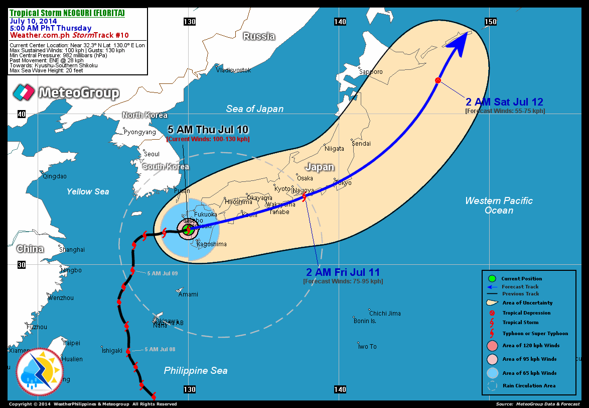
As of 5:00 AM PhT today...2100 GMT.
Location: Over the west coast of Kyushu, Japan (near 32.3N 130.0E)
About: 55 km south-southeast of Nagasaki, Japan...or 90 km north-northwest of Kagoshima, Japan
Maximum Sustained Winds (1-min avg): 100 kph near the center...Gustiness: 130 kph
24 hr. Rain Accumulation (near and south of the center): 50 to 250 mm [Moderate to Heavy]
Size (in diameter): 990 km (Average)
Past Movement: East-Northeast @ 28 kph
Forecast Movement: East-Northeast @ 35 kph
Towards: Kyushu-Southern Shikoku Area
2-DAY FORECAST OUTLOOK*
TS Neoguri (Florita) is expected to move generally east-northeastward during the next 24 hours...and will slightly turn back to the northeast with a much faster forward speed through 48 hours. On the forecast track, the storm will traverse Southern Shikoku, Japan this afternoon and will be passing along the southern shores of Honshu, Japan this evening through Friday. By early Saturday morning, Neoguri will be over the Northwest Pacific Ocean, approaching the western part of Kuril Islands.
Neoguri (Florita) will continue to rapidly lose strength through the next 24 to 48 hours while moving along the Southern Coasts of Japan due to unfavorable atmospheric conditions and the effect of Japanese terrain which will also lead Neoguri to Extratropical transition. Advance Intensity Forecast (AIF) shows its 1-minute maximum sustained winds decreasing to 55 kph by early Saturday morning.
The following is the summary of the 2-day forecast outlook on this system:
FRIDAY EARLY MORNING: Traversing ENE across the Southern Shoreline of Honshu...becoming an Extratropical Cyclone (aka. Middle-latitude Cyclone)...about 225 km WSW of Tokyo, Japan [2AM JUL 11: 34.5N 137.7E @ 75kph]. SATURDAY EARLY MORNING: Rapidly accelerates towards the northeast, approaching Kuril Islands...becomes Extratropical...about 280 km SSW of Kuril Islands [2AM JUL 12: 42.2N 146.6E @ 55kph].
*Please be reminded that the Forecast Outlook changes every 6 hours, and the Day 2 and 3 Forecast Track has an average error of 100 and 250 km respectively...while the wind speed forecast error, averages 35 kph per day. Therefore, a turn to the left or right of its future track and changes in its wind speed must be anticipated from time to time.
Important Note: Please keep in mind that the above hazards summary and forecast outlook changes every 6 to 12 hrs!
ADDITIONAL DISTANCES & TECHNICAL INFO
Time/Date: 5:00 AM PhT Thu Jul 10, 2014
Class/Name: TYS Neoguri (Florita)
Minimum Central Pressure: 982 millibars (hPa)
Location of Center: Near 32.3º N Lat 130.0º E Lon
Distance 1: 55 km SSE of Nagasaki, Japan
Distance 2: 105 km SSE of Sasebo, Japan
Distance 3: 90 km NNW of Kagoshima, Japan
Distance 4: 360 km WSW of Kochi, Japan
Distance 5: 970 km WSW of Tokyo, Japan
T2K/WP StormTrack (for Public): GIF
CURRENT TRACKING MAP:
_____________________________________________________________________________

__________________________________________________________________________________________________
CURRENT NOAA/MTSAT-2 INFRARED (IR) SATELLITE IMAGE:

__________________________________________________________________________________________________
>> To know the meteorological terminologies and acronyms used on this update visit the ff:
http://typhoon2000.ph/tcterm.htm
http://www.nhc.noaa.gov/aboutgloss.shtml
http://www.nhc.noaa.gov/acronyms.shtml
__________________________________________________________________________________________
For the complete details on TS NEOGURI (FLORITA)...go visit our website @:
> http://www.typhoon2000.com
> http://www.maybagyo.com
Copyright © 2014 Typhoon2000.com All Rights Reserved
Posted by: "Typhoon2000.com (Michael V. Padua)" <T2Kstormupdates@gmail.com>
| Reply via web post | • | Reply to sender | • | Reply to group | • | Start a New Topic | • | Messages in this topic (1) |

No comments:
Post a Comment