
for Thursday, 10 July 2014 [7:21 AM PhT]
WEATHER.COM.PH TROPICAL CYCLONE UPDATES
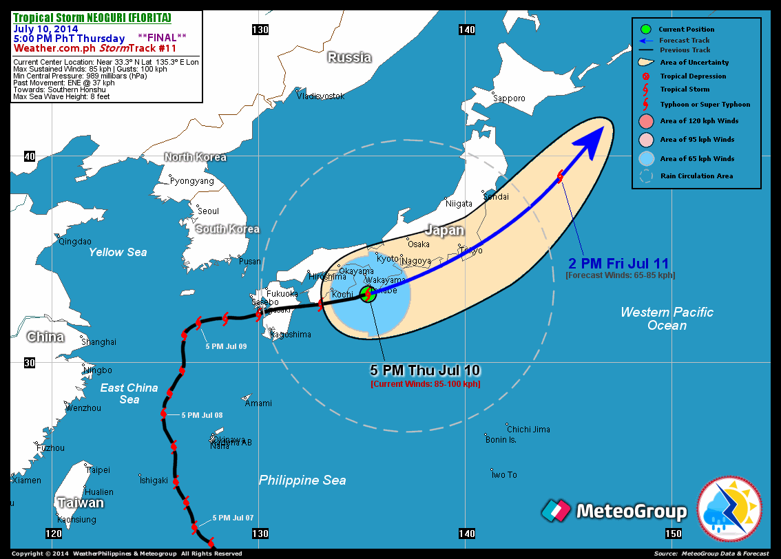
TROPICAL STORM NEOGURI (FLORITA) UPDATE NUMBER 011 [FINAL]
Issued at: 6:30 PM PhT (22:30 GMT) Thursday 10 July 2014
Tropical Storm NEOGURI (FLORITA) rapidly accelerating across the southern shores of Honshu, Japan...will become an Extratropical Cyclone (aka. Middle-Latitude Cyclone) within the next 12 to 24 hours.
Meanwhile, Tropical Disturbance 92W (LPA) - a rapidly developing, compact system over the Caroline Islands just north of Chuuk Island off Central Micronesia. As of 5:00 pm today, its center was estimated about 705 km ESE of Guam (near 10.6N 150.6E)...with maximum winds of 35-45 kph near the center, and was moving northwestward at 15 kph towards Mariana Islands. Various dynamic forecast models indicate this system will become a Tropical Cyclone within the next 12 to 24 hours. The models also show its movement similar to the track of Super Typhoon Neoguri (Florita) and could be tracking along the Philippine Sea in the middle of next week (July 16).
*This is the last and final update on TS Neoguri (Florita).
Information based on data collected by WeatherPhilippines Foundation, Inc. shall not be taken as official data. Weather information broadcasted and distributed by PAGASA remains as official data. WeatherPhilippines shall not be responsible for the private use and reliance of its weather information.
CYCLONE HAZARDS AFFECTING LAND
Below are the regions or places in the Philippines with possible effects caused by the current tropical cyclone.
 None.
None.
CURRENT CYCLONE INFORMATION
As of 5:00 PM PhT today...0900 GMT.
Location: Over the southwestern shores of Honshu, Japan (near 33.3N 135.3E)
About: 45 km south of Tanabe, Japan...or 485 km west-southwest of Tokyo, Japan
Maximum Sustained Winds (1-min avg): 85 kph near the center...Gustiness: 100 kph
24 hr. Rain Accumulation (near and south of the center): 25 to 150 mm [Slight to Heavy]
Size (in diameter): 990 km (Average)
Past Movement: East-Northeast @ 37 kph
Forecast Movement: Northeast @ 48 kph
Towards: Southern Honshu
1-DAY FORECAST OUTLOOK*
TS Neoguri (Florita) is expected to move generally east-northeastward during the next 12 hours...and will slightly turn back to the northeast with a much faster forward speed through 24 hours. On the forecast track, the storm will traverse Southern Honshu, Japan this evening and will be passing over or very close to Metropolitan Tokyo. By Friday afternoon, Neoguri will be over the Northwest Pacific Ocean, approaching the western part of Kuril Islands.
Neoguri (Florita) will continue to lose strength within the next 12 to 24 hours while moving along the Southern Coasts of Japan and will complete Extratropical transition tonight. Advance Intensity Forecast (AIF) shows its 1-minute maximum sustained winds decreasing to 65 kph by Friday afternoon.
The following is the summary of the 1-day forecast outlook on this system:
FRIDAY AFTERNOON: Rapidly moving northeasterly across the NW Pacific Ocean, becomes an Extratropical Cyclone (aka. Middle-latitude Cyclone)...about 330 km ENE of Sendai, Japan [2PM JUL 11: 39.0N 144.6E @ 65kph].
*Please be reminded that the Forecast Outlook changes every 6 hours, and the Day 2 and 3 Forecast Track has an average error of 100 and 250 km respectively...while the wind speed forecast error, averages 35 kph per day. Therefore, a turn to the left or right of its future track and changes in its wind speed must be anticipated from time to time.
Important Note: Please keep in mind that the above hazards summary and forecast outlook changes every 6 to 12 hrs!
ADDITIONAL DISTANCES & TECHNICAL INFO
Time/Date: 5:00 PM PhT Thu Jul 10, 2014
Class/Name: TS Neoguri (Florita)
Minimum Central Pressure: 989 millibars (hPa)
Location of Center: Near 33.3º N Lat 135.3º E Lon
Distance 1: 45 km S of Tanabe, Japan
Distance 2: 100 km SSE of Wakayama, Japan
Distance 3: 160 km ESE of Kochi, Japan
Distance 4: 255 km SW of Kochi, Japan
Distance 5: 485 km WSW of Tokyo, Japan
T2K/WP StormTrack (for Public): GIF
CURRENT TRACKING MAP:
_____________________________________________________________________________

__________________________________________________________________________________________________
CURRENT NOAA/MTSAT-2 INFRARED (IR) SATELLITE IMAGE:

__________________________________________________________________________________________________
>> To know the meteorological terminologies and acronyms used on this update visit the ff:
http://typhoon2000.ph/tcterm.htm
http://www.nhc.noaa.gov/aboutgloss.shtml
http://www.nhc.noaa.gov/acronyms.shtml
__________________________________________________________________________________________
For the complete details on TS NEOGURI (FLORITA)...go visit our website @:
> http://www.typhoon2000.com
> http://www.maybagyo.com
Copyright © 2014 Typhoon2000.com All Rights Reserved
Posted by: "Typhoon2000.com (Michael V. Padua)" <T2Kstormupdates@gmail.com>
| Reply via web post | • | Reply to sender | • | Reply to group | • | Start a New Topic | • | Messages in this topic (1) |

No comments:
Post a Comment