
for Monday, 09 August 2010 [8:38 AM PhT]

<<<Typhoon2000.
Get the latest 6-hrly SMS Storm Alerts on ESTER!
For more details: Text T2K TYPHOON to
2800 (Globe/TM) | 216 (Smart/TNT) | 2288 (Sun)
*only P2.50 (Smart/Globe) / P2.00 (Sun) per msg received.
powered by: Synermaxx
Typhoon2000 (T2K) NEWS (Mon August 09 2010):
8AM Updated Position of DIANMU: 25.6N 125.6E. Currently issuing 6-hrly advisiories (except 12 AM PhT) on TS DIANMU (ESTER).
DIANMU (ESTER) MAX WIND SPEED PER AGENCY:
+ USA (JTWC/1-min avg): 65 km/hr
+ Japan (JMA/10-min avg): 65 km/hr
+ Philippines (PAGASA/10-min avg): 85 km/hr
+ Korea (KMA/10-min avg): 80 km/hr
+ Hong Kong (HKO/10-min avg): 65 km/hr
+ Taiwan (CWB/10-min avg): 65 km/hr
+ Beijing (NMC/2-min avg): 65 kph
TROPICAL STORM DIANMU [ESTER/05W/1004]
T2K EMAIL ADVISORY NUMBER 006
7:00 AM PhT (23:00 GMT) Mon 09 August 2010
Source: T2K Analysis/JTWC Warning #004/SatFix
View: Advisory Archives (2004-2010)
*Residents and visitors along Yaeyama-Okinawa-
*Do not use this for life or death decision. This advisory is intended for additional information purposes only. Kindly refer to your country's official weather agency for local warnings, advisories & bulletins.
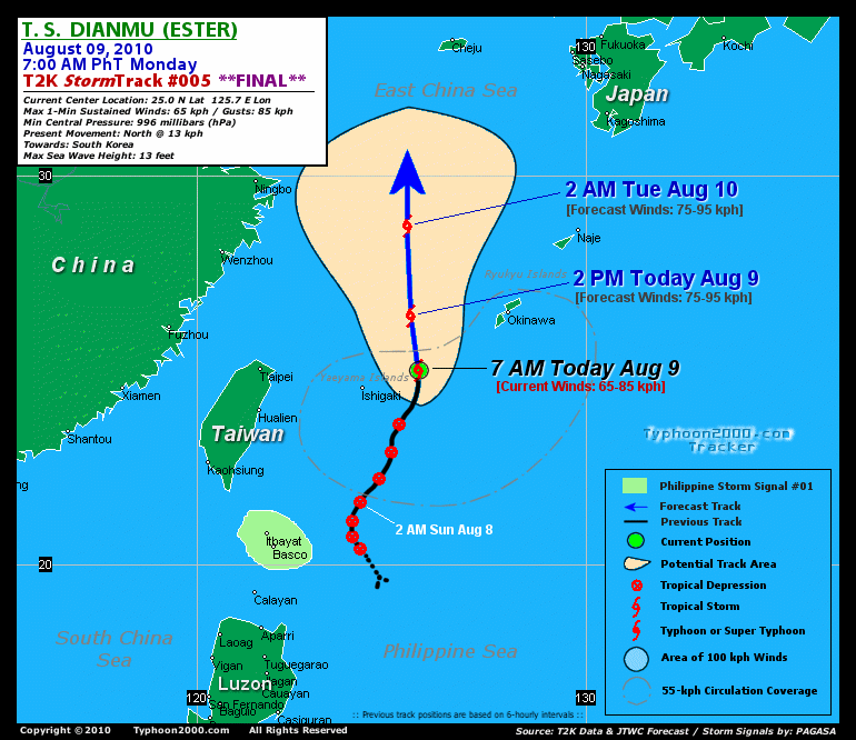
Current Storm Information + Forecast Outlook: DIANMU is expected to continue tracking Northward and intensify further within the next 12 to 24 hours. It will reach its peak intensity of 85 kph by tomorrow afternoon - while moving into the warmer waters of the East China Sea [2PM AUG 10: 31.0N 125.2E @ 85kph]. The 2 to 4-Day Long-Range Forecast Track shows the system weakening while passing very close to the west of Cheju Island by early Wednesday morning [2AM AUG 11: 32.9N 125.6E @ 85kph]. DIANMU shall make landfall and cross South Korea by Wednesday afternoon, passing very close to Taegu City. It shall then move out into the Sea of Japan around Thursday and become an Extratropical Cyclone (ET) by Friday [2AM AUG 13: 38.6N 136.3E @ 65kph]. Please be reminded that the Forecast Outlook changes every 6 hours, so a turn to the left or right of its future track and other possibilities must be considered.
Time/Date: 7:00 AM PhT Mon Aug 09 2010
Location of Center: 25.0º N Lat 125.7º E Lon
Distance 1: 155 km (83 nm) ENE of Ishigaki, Japan
Distance 2: 290 km (157 nm) SW of Okinawa, Japan
Distance 3: 415 km (225 nm) East of Taipei, Taiwan
Distance 4: 430 km (233 nm) ENE of Hualien, Taiwan
Distance 5: 630 km (340 nm) NE of Basco, Batanes
MaxWinds (1-min avg): 65 kph (35 kts) near the center
Peak Wind Gusts: 85 kph (45 kts)
6-hr Rain Amounts (near the center): 200 mm [Heavy]
Minimum Central Pressure: 996 millibars (hPa)
Saffir-Simpson Typhoon Scale: Tropical Storm
Present Movement: North @ 13 kph (07 kts)
Towards: South Korea
Size (in Diameter): 610 km (330 nm) / Average
Max Sea Wave Height (near center): 13 ft (3.9 m)
Coastal Storm Surge Height: 0-4 feet [0-1.2 m]
T2K Final TrackMap #006 (for Public): 7 AM PhT Mon Aug 09
+ Effects & Hazards: DIANMU's circulation particularly its inner bands is currently affecting the Yaeyama and Okinawa-Ryukyu Island Chains. Intense rain and wind convection remains to the South & SE quadrants of the tropical storm. Strong winds of up to 60 kph can be expected along these island chains. Click here to view the latest NOAA-CIRA's Wind Analysis. 6-hr total rainfall amounts of 5 up to 100 mm (light to moderate rain) can be expected along the outer and inner rainbands...
+ Current SW Monsoon Intensity: STRONG >> Mostly cloudy skies with passing light to moderate to sometimes heavy rains can be expected along the following affected areas: NORTHERN & WESTERN LUZON including portions of METRO MANILA, LUBANG ISLAND & CALAMIAN GROUP OF ISLANDS. Moderate to strong SW winds (not in excess of 45 kph) can be expected along these areas. Large ocean waves of 7 to 8 feet along the beach-front areas of the affected areas are likely to occur today. Possible landslides, mudslides, mudflows (lahars) and life-threatening flash floods are likely to occur along steep mountain/volcanic slopes, river banks, low-lying & flood-prone areas of the affected areas.
+ Tropical Cyclone Watch: [Important Note: Please keep in mind that the above forecast outlook, effects, current monsoon intensity, & tropical cyclone watch changes every 6 to 12 hrs!] PHILIPPINE STORM WARNING SIGNAL # ONE (1) The above area will have rains and winds of not more than 60 kph this morning. Coastal waters will be moderate to rough.
A new, developing Tropical Disturbance 99W (LPA/1010 MB) was detected just south of the Pacific island of Yap, and has been tracking Westward @ 20 kph. Located near lat 8.5N lon 138.0E...or about 1,275 km East of Mindanao, Philippines.![]()
PAGASA's Philippine Storm Warnings Signals

In Effect: BATANES GROUP OF ISLANDS.
Residents living in low-lying and mountainous areas under Public Storm Warning Signal Number 1 are alerted against flashfloods, mudflows, mudslides and landslides.
External Links for TS DIANMU (ESTER)
View NOAA-CIRA's Latest Wind Analysis
Zoomed Satellite Pic: NOAA's Near Real-Time
JTWC Latest Tracking Chart: wp0510.gif
Multi-Agency Forecast TrackMap: Near Real-Time
TSR Wind Probabilities: Current to 96 hrs Ahead
NASA-JAXA TMI Page: Latest Rainrate 01
EORC-JAXA TRMM Page: Latest Rainrate 02
*RECENT ANIMATED INFRARED SATELLITE
IMAGERY AND A 081742Z AMSRE 36 GHZ MICROWAVE IMAGE DEPICT A
PARTIALLY EXPOSED LOW LEVEL CIRCULATION CENTER WITH INCREASED LOW
LEVEL BANDING ALONG THE NORTHERN PERIPHERY OF THE SYSTEM AND
CONTINUED DEEP CONVECTION ALONG THE SOUTHERN AND EASTERN QUADRANTS.
THE CURRENT INTENSITY IS BASED ON DVORAK ESTIMATES RANGING FROM 30
TO 35 KNOTS FROM PGTW, KNES, AND RJTD. A 081225Z ASCAT PASS REVEALS
30 TO 35 KNOT WINDS ALONG THE EASTERN HALF OF THE SYSTEM AND 20 TO
30 KNOT WINDS ALONG THE NORTHERN AND WESTERN QUADRANTS. UPPER LEVEL
ANALYSIS INDICATES THE SYSTEM IS EXPERIENCING GOOD EQUATORWARD
OUTFLOW AND INCREASED DIFFLUENCE ALOFT ALONG THE SOUTHEASTERN
PERIPHERY OF THE SYSTEM. HOWEVER, DEEP CONVECTION ALONG THE NORTHERN
PERIPHERY OF THE SYSTEM CONTINUES TO BE SUPPRESSED BY AN UPPER LEVEL
TROUGH. TS 05W IS EXPECTED TO GRADUALLY INTENSIFY AS IT CONTINUES
TRACKING NORTHWARD OVER WARM SEA SURFACE TEMPERATURES AND THROUGH AN
AREA OF LOW VERTICAL WIND SHEAR. THE SYSTEM IS EXPECTED TO REACH A
PEAK INTENSITY OF 45 KNOTS BETWEEN TAU 36 AND TAU 48. NEAR TAU 72
THE SYSTEM IS FORECAST TO WEAKEN SLIGHTLY AS IT TRACKS OVER SOUTH
KOREA AND BEGINS TO INTERACT WITH THE BAROCLINIC ZONE. BY TAU 96 TS
DIANMU IS EXPECTED TO COMPLETE EXTRATROPICAL TRANSITION. NUMERICAL
MODEL GUIDANCE IS IN GOOD AGREEMENT, WITH THE EXCEPTION OF ECMWF
WHICH SHOWS THE SYSTEM RECURVING FASTER TO THE EAST. THIS FORECAST
IS IN AGREEMENT WITH MODEL CONSENSUS...(more)
>> DIANMU, meaning: Mother of lightning. Name contributed by: China.
RECENT TYPHOON2000 TRACKING CHART:
________________________
RECENT MULTI-AGENCY TROPICAL CYCLONE FORECAST TRACKING CHART:

________________________

> Image source: NOAA SATELLITE CENTER
> Image source: Wunderground.

> Image source: NOAA Satellite & Information Service (http://www.ssd.
>> To know the meteorological terminologies and acronyms used on this update visit the ff:
http://typhoon2000.
http://www.nhc.
http://www.srh.
http://www.srh.
http://www.nhc.
____________
> http://www.typhoon2
> http://www.maybagyo
Copyright © 2010 Typhoon2000.

No comments:
Post a Comment