
for Sunday, 08 August 2010 [6:59 AM PhT]

<<<Typhoon2000.
Get the latest 6-hrly SMS Storm Alerts on ESTER!
For more details: Text T2K TYPHOON to
2800 (Globe/TM) | 216 (Smart/TNT) | 2288 (Sun)
*only P2.50 (Smart/Globe) / P2.00 (Sun) per msg received.
powered by: Synermaxx
Typhoon2000 (T2K) NEWS (Sat August 07 2010):
Currently issuing 6-hrly web advisiories (except 12 AM PhT) on TD 96W (ESTER).
96W (ESTER) MAX WIND SPEED PER AGENCY:
+ USA (JTWC/1-min avg): 35 km/hr
+ Japan (JMA/10-min avg): 55 km/hr
+ Philippines (PAGASA/10-min avg): 55 km/hr
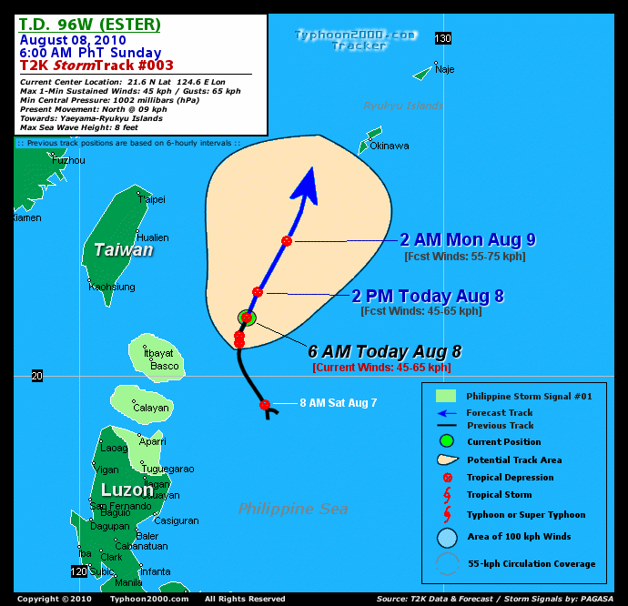
TROPICAL DEPRESSION 96W [ESTER]
T2K EMAIL ADVISORY NUMBER 003
6:00 AM PhT (22:00 GMT) Sun 08 August 2010
Source: T2K Analysis/JTWC SatFix
View: Advisory Archives (2004-2010)
*Residents and visitors along Taiwan, Ryukyu-Yaeyama Islands, & Calayan-Babuyan-
*Do not use this for life or death decision. This advisory is intended for additional information purposes only. Kindly refer to your country's official weather agency for local warnings, advisories & bulletins.
Current Storm Information + Forecast Outlook: 96W is expected to turn more to the NNE for the next 6 to 24 hours and accelerate slightly in the direction of Yaeyama-Okinawa-
Time/Date: 6:00 AM PhT Sun Aug 08 2010
Location of Center: 21.6º N Lat 124.6º E Lon
Distance 1: 295 km (160 nm) ENE of Basco, Batanes
Distance 2: 405 km (220 nm) SE of Hualien, Taiwan
Distance 3: 465 km (250 nm) NNE of Aparri, Cagayan
Distance 4: 485 km (262 nm) SE of Taipei, Taiwan
Distance 5: 645 km (348 nm) SW of Okinawa, Japan
MaxWinds (1-min avg): 45 kph (25 kts) near the center
Peak Wind Gusts: 65 kph (35 kts)
6-hr Rain Amounts (near the center): 200 mm [Heavy]
Minimum Central Pressure: 1002 millibars (hPa)
Saffir-Simpson Typhoon Scale: Tropical Depression
Present Movement: Quasi-Stationary
Towards: Yaeyama-Ryukyu Islands
Size (in Diameter): 400 km (215 nm) / Average
Max Sea Wave Height (near center): 8 ft (2.4 m)
Coastal Storm Surge Height: 0 feet [0 m]
T2K TrackMap #003 (for Public): 6 AM PhT Sun Aug 08
+ Effects & Hazards: 96W's circulation is currently over the Northern Philippine Sea and continues to pull the Southwest Monsoon across the Philippines. Its outer bands continues to affect the Extreme Northern Islands of Luzon - moderate to strong winds of up to 45 kph w/ occasional rains can be expected along Calayan Islands, Balintang Channel, Batanes & Babuyan Group of Islands. Click here to view the latest NOAA-CIRA's Wind Analysis. Residents in low-lying areas & steep slopes must remain alert & seek evacuation for possible life-threatening flash floods, mudslides & landslides due to the anticipated heavy rains brought about by this system. Precautionary measures must be initiated if necessary.
+ Current SW Monsoon Intensity: STRONG >> Mostly cloudy skies with passing moderate to heavy rains can be expected along the following affected areas: NORTHERN-CENTRAL-
+ Tropical Cyclone Watch: [Important Note: Please keep in mind that the above forecast outlook, effects, current monsoon intensity, & tropical cyclone watch changes every 6 to 12 hrs!] PHILIPPINE STORM WARNING SIGNAL # ONE (1) The above areas will have rains and winds of not more than 60 kph today. Coastal waters will be moderate to rough.
Weak Tropical Disturbance 98W (LPA/1003 MB) almost stationary over the South China Sea, close to Hainan Island. Located near lat 18.0N lon 112.0E...or about 910 km West of Laoag City...with 1-min maximum sustained winds of 25 kph near the center. This system has a 30% chance of becoming a Tropical Cyclone w/in the next 24 to 48 hours. ![]()
PAGASA's Philippine Storm Warnings Signals

In Effect: BATANES GROUP OF ISLANDS, CALAYAN ISLAND, CAGAYAN, AND BABUYAN ISLANDS.
Residents living in low-lying and mountainous areas under Public Storm Warning Signal Number 1 are alerted against flashfloods, mudflows, mudslides and landslides.
External Links for TD 96W (ESTER)
View NOAA-CIRA's Latest Wind Analysis
Zoomed Satellite Pic: NOAA's Near Real-Time
RECENT TYPHOON2000 TRACKING CHART:
________________________

> Image source: NOAA SATELLITE CENTER
>> To know the meteorological terminologies and acronyms used on this update visit the ff:
http://typhoon2000.
http://www.nhc.
http://www.srh.
http://www.srh.
http://www.nhc.
____________
> http://www.typhoon2
> http://www.maybagyo
Copyright © 2010 Typhoon2000.

No comments:
Post a Comment