Typhoon2000 STORM UPDATE #004
Name: TROPICAL DEPRESSION 17W [UNNAMED]
Issued: 7:00 AM MANILA TIME (23:00 GMT) MON 25 SEPTEMBER 2006
Next Update: 7:00 PM (11:00 GMT) MON 25 SEPTEMBER 2006
Source: JTWC TROPICAL CYCLONE WARNING #008
_______________________________________________________________________
Next Update: 7:00 PM (11:00 GMT) MON 25 SEPTEMBER 2006
Source: JTWC TROPICAL CYCLONE WARNING #008
____________
TROPICAL DEPRESSION 17W (UNNAMED) MOVES ONSHORE ALONG
CENTRAL VIETNAM...DISSIPATION EXPECTED .
CENTRAL VIETNAM...DISSIPATI
+ FORECAST OUTLOOK: 17W is expected to move Westward to
a more WSW dip across Central Vietnam and Southern Cam-
bodia this afternoon and dissipate along Thailand early
tomorrow.
+ EFFECTS: 17W's circulation continues to spread across
Central Vietnam, Southern Cambodia & portions of Thailand
including Western Hainan Is, China. Moderate to heavy
rains and winds not in excess of 55 km/hr can be expected
along the path of 17W.
+ TROPICAL CYCLONE WATCH: The Tropical Disturbance (LPA/
99W/1004 mb) over the Philippine Sea has strengthened and
is likely to become a Tropical Depression within the next
24 hours. It was located about 315 km ESE of Borongan,
Eastern Samar (11.4N 128.3E)...almost stationary with
winds of 35 km/hr. Watch for a separate page on this
system once it becomes a Tropical Depression.
outlook, effects & current monsoon intensity, and tropical
cyclone watch changes every 06 to 12 hours!
____________
TIME/DATE: 5:00 AM MANILA TIME (21:00 GMT) 25 SEPTEMBER
LOCATION OF CENTER: LATITUDE 16.8º N...LONGITUDE 107.6º E
DISTANCE 1: 35 KM (20 NM) NORTH OF HUE, VIETNAM
DISTANCE 2: 100 KM (55 NM) NW OF DA NANG, VIETNAM
DISTANCE 3: 245 KM (132 NM) SW OF SANYA, HAINAN IS., CHINA
PEAK WIND GUSTS: 75 KM/HR (40 KTS)
SAFFIR-SIMPSON SCALE: N/A
MINIMUM CENTRAL PRESSURE (est.): 1000 MILLIBARS (hPa)
RECENT MOVEMENT: WEST @ 15 KM/HR (08 KTS)
GENERAL DIRECTION: CENTRAL VIETNAM
STORM'S SIZE (IN DIAMETER): ... KM (... NM)/N/A
MAX WAVE HEIGHT**: 12 FEET (3.6 METERS)
VIEW TRACKING MAP: 2 AM HKT TIME MON SEPTEMBER 25
TSR WIND PROBABILITIES: CURRENT TO 24 HRS LEAD
PHILIPPINE STORM SIGNALS*: N/A
12, 24 HR. FORECAST:
2 PM (06 GMT) 25 SEP: 16.9N 106.3E / 45-65 KPH / WEST @ 15 KPH
2 AM (18 GMT) 26 SEP: 16.6N 104.6E / 35-55 KPH / WSW @ 15 KPH
REMARKS: 2 APM (18 GMT) 25 SEPTEMBER POSITION: 16.8N 108.0E.
^RIDGING TO THE NORTH OF TD 17W HAS BUILT AS EXPECTED, FORCING
THE SYSTEM ON A MORE WESTWARD TRACK OVER THE PAST 12 HOURS.
THIS TRACK WILL CONTINUE UNTIL THE SYSTEM MAKES LANDFALL PRIOR
TO 12 HOURS. FORECAST MODEL GUIDANCE IS IN POOR AGREEMENT WITH
TRACK, MAINLY DUE TO THE WEAKNESS OF THE SYSTEM. THIS FORECAST
IS BASED ON SATELITTE ANALYSIS OF THE SYNOPTIC PATTERN...
(more info)
____________
____________
RECENT WEATHER UNDERGROUND TRACKING CHART:
Track Source: The Weather Underground Tropical Page (http://www.wundergr
________________________
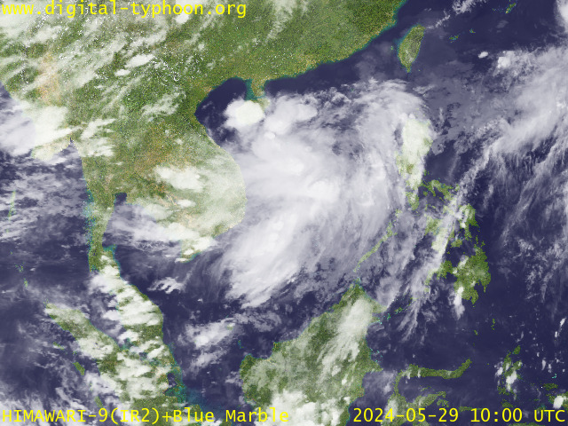
RECENT MTSAT-1R SATELLITE IMAGE:

> Image source: Digital-Typhoon.org (Nat'l. Institute of Informatics) (http://www.digital-typhoon.org )
__________________________________________________________________________________________
NOTES:

> Image source: Digital-Typhoon.
^ - JTWC commentary remarks (for Meteorologists) from their
latest warning.
latest warning.
* - Based on PAGASA's Philippine Storm Warning Signals,
# 4 being the highest. Red letters indicate new areas
being hoisted. For more explanations on these signals,
visit: http://www.typhoon2000.ph/signals.htm
** - Based on the Tropical Cyclone's Wave Height near
its center.
__________________________________________________________________________________________
>> To know the meteorological terminologies and acronyms
used on this update visit the ff:
http://typhoon2000.ph/tcterm.htm
http://www.nhc.noaa.gov/aboutgloss.shtml
http://www.srh.noaa.gov/oun/severewx/glossary.php
http://www.srh.weather.gov/fwd/glossarynation.html
http://www.nhc.noaa.gov/acronyms.shtml
__________________________________________________________________________________________
:: Typhoon2000.com (T2K) Mobile >> Powered by: Synermaxx
Receive the latest storm updates directly to your mobile phones! To know more:
Send T2K HELP to: 2800 (GLOBE & TM) | 216 (SMART & TNT) | 2288 (SUN)
Note: Globe & Smart charges P2.50 per message, while Sun at P2.00.
__________________________________________________________________________________________
For the complete details on TD 17W (UNNAMED)...go visit
our website @:
> http://www.typhoon2000.com
> http://www.maybagyo.com
# 4 being the highest. Red letters indicate new areas
being hoisted. For more explanations on these signals,
visit: http://www.typhoon2
** - Based on the Tropical Cyclone's Wave Height near
its center.
____________
>> To know the meteorological terminologies and acronyms
used on this update visit the ff:
http://typhoon2000.
http://www.nhc.
http://www.srh.
http://www.srh.
http://www.nhc.
____________
:: Typhoon2000.
Receive the latest storm updates directly to your mobile phones! To know more:
Send T2K HELP to: 2800 (GLOBE & TM) | 216 (SMART & TNT) | 2288 (SUN)
Note: Globe & Smart charges P2.50 per message, while Sun at P2.00.
For the complete details on TD 17W (UNNAMED)...
our website @:
> http://www.typhoon2
> http://www.maybagyo
Change settings via the Web (Yahoo! ID required)
Change settings via email: Switch delivery to Daily Digest | Switch format to Traditional
Visit Your Group | Yahoo! Groups Terms of Use | Unsubscribe
SPONSORED LINKS
.
__,_._,___
No comments:
Post a Comment