
WEATHER.COM.PH / T2K TROPICAL CYCLONE UPDATES
TROPICAL STORM SONAMU (AURING) UPDATE NUMBER 007
Issued: 7:00 AM PhT (23:00 GMT) Saturday 05 Jan 2013
Next Update: 1:00 PM PhT (05:00 GMT) Saturday 05 Jan 2013
Tropical Storm Sonamu (Auring) moving west-southwest across the South China Sea. Rainbands approaching the coast of Southern Vietnam.
Residents and visitors along Southern Vietnam & Malaysia should closely monitor the development of Sonamu (Auring).
Do not use this for life or death decision. This update is intended for additional information purposes only. Kindly refer to your national weather agency for official warnings, advisories or bulletins.
CURRENT STORM ANALYSIS
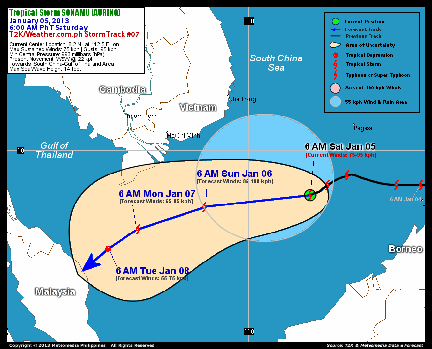
As of 6 AM today, the center of Tropical Storm Sonamu (Auring) was located over the South China Sea...about 378 km south-southwest of Pagasa Island, Spratlys or 573 km southeast of Nha Trang City, Vietnam...currently moving west-southwest with a forward speed of 22 km/hr in the general direction of the South China Sea-Gulf of Thailand Area.
Maximum Sustained Winds (1-min. avg) are at 75 km/hr near the center with higher gusts. Sonamu (Auring) is an average-sized tropical cyclone with a diameter of 390 kilometers across. The 24-hour rainfall accumulation near the center and to the northwest of TS Sonamu is estimated to be extreme (400 mm).
3-DAY FORECAST OUTLOOK*
Tropical Storm Sonamu (Auring) is expected to move west-southwest to southwestward throughout the forecast period. On the forecast track, the core of Sonamu (Auring) is expected to continue moving across the South China Sea through Sunday...and should be approaching the Malaysian coastline on Tuesday.
Sonamu (Auring) is forecast to strengthen on Sunday...before losing strength on Monday while approaching the Malaysian Coast.
The following is the summary of the 3-day forecast outlook on this system:
 SUNDAY MORNING: Intensifies while moving west-southwest across the South China Sea...about 382 km southeast of Ho Chi Minh City, Vietnam [6AM JAN 06: 7.7N 108.2E @ 85kph].
MONDAY MORNING: Starts to weaken as it turns southwestward...about 464 km south-southwest of Ho Chi Minh City [6AM JAN 07: 6.8N 105.5E @ 65kph].
TUESDAY MORNING: Downgraded to a Tropical Depression as it approaches the coast of Malaysia...about 595 km south-southwest of Ho Chi Minh City [6AM JAN 08: 6.0N 104.3E @ 55kph].
EFFECTS & HAZARDS SUMMARY
Below is the summary of the storm's parts and its hazards affecting specific areas. You can also view this image link for you to understand the parts.
INNER RAINBANDS - over water (West Philippine Sea)...not affecting any land areas. Tropical Storm Conditions with Tropical Storm Force Winds (62-95 kph) will be expected along these bands. OUTER RAINBANDS - affecting and spreading across the coastal areas of Southern Vietnam. Tropical Depression Conditions with light to moderate winds (05-61 kph) will be expected along these bands (click here to know more about Rainbands). 24HR TOTAL RAINFALL ACCUMULATION - from 5 up to 200 mm (slight to heavy rainfall) can be expected along areas affected by the developing rainbands (see above)...with isolated amounts of 201 to 400 mm (heavy to extreme) along areas near, north and west of the center of TS Sonamu (Auring).
Important Note: Please keep in mind that the above forecast outlook, effects and hazards summary changes every 6 to 12 hrs!
CURRENT TECHNICAL INFORMATION
Time/Date: 6:00 AM PhT Sat January 05, 2013
Class/Name: TS Sonamu (Auring)
Location of Center: 8.2º N Lat 112.5º E Lon
Distance 1: 378 km (SSW) away from Pagasa Is., Spratlys
Distance 2: 573 km (SE) from Nha Trang, Vietnam
Distance 3: 694 km (ESE) away from Ho Chi Minh City
MaxWinds (1-min avg): 75 kph near the center
Peak Wind Gusts: 95 kph
Present Movement: WSW @ 22 kph
Towards: South China Sea
24hr Rainfall Accum (near center): Extreme [400 mm]
Minimum Central Pressure: 993 millibars (hPa)
Size (in Diameter): 390 km [Average]
Max Sea Wave Height (near center): 14 feet
Possible Storm Surge Height: 1-3 ft (0.3-0.9 m)
T2K/WP StormTracks (for Public): GIF | Google Map (Flash)

CURRENT NOAA/MTSAT-2 INFRARED SATELLITE IMAGE:

CURRENT TRACKING CHART:
_____________________________________________________________________________
>> To know the meteorological terminologies and acronyms used on this update visit the ff:
http://typhoon2000.ph/tcterm.htm
http://www.nhc.noaa.gov/aboutgloss.shtml
http://www.nhc.noaa.gov/acronyms.shtml
__________________________________________________________________________________________
For the complete details on TS SONAMU (AURING)...go visit our website @:
> http://www.typhoon2000.com
> http://www.maybagyo.com
<<<Typhoon2000.com Mobile >>>
Get the latest SMS Storm Alerts!
For more details: Text T2K TYPHOON to
2800 (Globe/TM) | 216 (Smart/TNT) | 2288 (Sun)
*Only P2.50 (Smart/Globe) / P2.00 (Sun) per msg received.
Click here on how to use this service (in PDF file)
Powered by: Synermaxx Corporation
Copyright © 2012 Typhoon2000.com All Rights Reserved
| Reply via web post | Reply to sender | Reply to group | Start a New Topic | Messages in this topic (1) |

No comments:
Post a Comment