
for Wednesday, 14 July 2010 [6:49 PM PhT]

<<<Typhoon2000.
Get the latest 6-Hrly SMS Storm Alerts on BASYANG!
For more details: Text T2K TYPHOON to
2800 (Globe/TM) | 216 (Smart/TNT) | 2288 (Sun)
*only P2.50 (Smart/Globe) / P2.00 (Sun) per msg received.
powered by: Synermaxx
Typhoon2000 (T2K) NEWS (Wed July 14 2010):
Currently issuing 6-hrly updates (except 12 AM PhT) on TS CONSON (BASYANG).
CONSON (BASYANG) MAX WIND SPEED PER AGENCY:
+ USA (JTWC/1-min avg): 95 km/hr
+ Japan (JMA/10-min avg): 85 km/hr
+ Philippines (PAGASA/10-min avg): 85 km/hr
+ Korea (KMA/10-min avg): 80 km/hr
+ Hong Kong (HKO/10-min avg): 95 km/hr
+ Taiwan (CWB/10-min avg): 85 km/hr
+ Beijing (NMC/2-min avg): 95 kph
TROPICAL STORM CONSON [BASYANG/03W/
T2K EMAIL ADVISORY NUMBER 010
6:00 PM PhT (10:00 GMT) Wed 14 July 2010
Source: T2K Analysis/JTWC Warning #012
View: Advisory Archives (2004-2010)
*Residents and visitors along Hainan Island & Southern China should closely monitor the progress of CONSON (BASYANG).
*Do not use this for life or death decision. This advisory is intended for additional information purposes only. Kindly refer to your country's official weather agency for local warnings, advisories & bulletins.
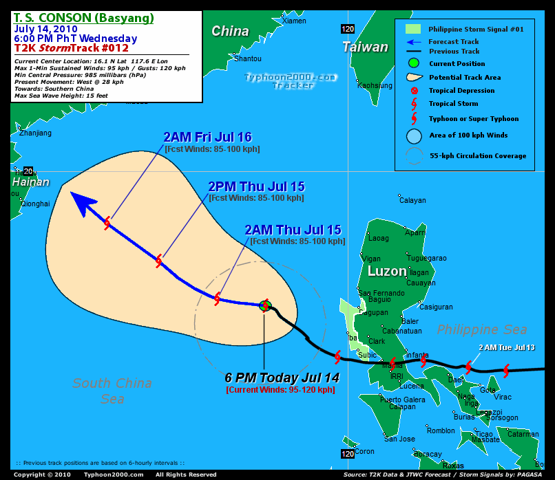
Current Storm Information
Time/Date: 6:00 PM PhT Wed Jul 14 2010
Location of Center: 16.1º N Lat 117.6º E Lon
Distance 1: 290 km (157 nm) West of Dagupan City
Distance 2: 295 km (160 nm) WSW of Sn.Fernando, La Union
Distance 3: 320 km (173 nm) WSW of Baguio City
Distance 4: 410 km (220 nm) NW of Metro Manila
Distance 5: 765 km (413 nm) SSE of Hong Kong
MaxWinds (1-min avg): 95 kph (50 kts) near the center
Peak Wind Gusts: 120 kph (85 kts)
6-hr Rain Amounts (near the center): 200 mm [Heavy]
Minimum Central Pressure: 985 millibars (hPa)
Saffir-Simpson Typhoon Scale: TS
Present Movement: NW @ 28 kph (15 kts)
Towards: Southern China
Size (in Diameter): 370 km (200 nm) / Average
Max Sea Wave Height (near center): 15 ft (4.5 m)
Coastal Storm Surge Height: 0-4 feet [0-1.2 m]
T2K TrackMap #012 (for Public): 6 PM PhT Wed Jul 14
+ Forecast Outlook: CONSON (BASYANG) is expected to continue tracking WNW to NW-ward across the South China Sea for the next 3 to 4 days...will exit the Philippine Area of Responsibility (PAR) tomorrow morning [2AM JUL 15: 16.3N 116.2E - 85kph]. The 4-Day Medium-Range Forecast shows the system making its final landfall by early Saturday morning along Western Guangdong (Southern China) or near Zhanjiang, China [2PM JUL 17: 22.3N 109.7E - 55kph]. Please be reminded that the Forecast Outlook changes every 6 hours, so a turn to the left or right of its future track and other possibilities must be considered.
+ Effects & Hazards: CONSON's (BASYANG) outer rainbands will still continue to affect Northern Palawan, Calamian Group, Lubang Island, Bataan, Metro Manila, Batangas, Zambales & Mindoro - winds not exceeding 40 kph w/ light to moderate rainfall can be expected along these areas. 6-hr total rainfall amounts of 5 up to 150 mm (light, moderate to heavy rain) can be expected along the outer and inner rainbands...
[Important Note: Please keep in mind that the above forecast outlook, effects, current monsoon intensity, & tropical cyclone watch changes every 6 to 12 hrs!]
PAGASA's Philippine Storm Warnings Signals
PHILIPPINE STORM WARNING SIGNAL # ONE (1)

In Effect: PANGASINAN, BATAAN, AND ZAMBALES.
The above areas will continue to have rains and winds of not more than 60 kph tonight. Coastal waters will be moderate to rough.
Residents living in low-lying and mountainous areas under Public Storm Warning Signal Number 1 are alerted against flashfloods, mudflows, mudslides and landslides..
External Links for TY CONSON (BASYANG)
View NOAA-CIRA's Latest Wind Analysis
JTWC Latest Tracking Chart: wp0310.gif
Multi-Agency Forecast TrackMap: 5 PM Wed Jul 14
TSR Wind Probabilities: Current to 96 hrs Ahead
Zoomed Satellite Pic: NOAA's Near Real-Time
Wunderground Animation: 6-12 hr. GIF Loop
REMARKS (for Meteorologists): 2PM (06 GMT) WED 14 JULY POSITION: 15.4N 118.4E.
*ANIMATED MULTISPECTRAL SATELLITE
IMAGERY DEPICTS A FULLY-EXPOSED LOW-LEVEL CIRCULATION CENTER (LLCC)
WITH LIMITED DEEP CONVECTION SHEARED 25 NM SOUTH OF THE CENTER.
THE LLCC REMAINS EMBEDDED WITHIN A BROAD AREA OF STRONG UPPER-LEVEL
NORTHEASTERLY FLOW ASSOCIATED WITH A STRONG ANTICYCLONE POSITIONED
OVER CENTRAL AND EASTERN CHINA. UPPER-LEVEL FEATURE TRACK WINDS AND
UPPER AIR DATA FROM XISHA DAO, LAOAG AND HAIKOU INDICATE 40-60 KNOT
NORTHEASTERLY TO EAST-NORTHEASTERLY FLOW COVERING THE SOUTH CHINA
SEA. THE CURRENT INTENSITY IS BASED ON AN AVERAGE OF DVORAK ESTIMATES
RANGING FROM 45 TO 55 KNOTS FROM KNES, PGTW AND RJTD. TS 03W IS
FORECAST TO TRACK NORTHWEST ALONG THE SOUTHWEST PERIPHERY OF THE
LOW- TO MID-LEVEL SUBTROPICAL RIDGE ENTRENCHED OVER CHINA THROUGH
THE FORECAST PERIOD AND SHOULD MAKE LANDFALL NEAR ZHANJIANG, CHINA
NEAR 16/18Z. NUMERICAL GUIDANCE IS TIGHTLY CLUSTERED, THEREFORE,
THIS FORECAST IS IN AGREEMENT WITH THE MODEL CONSENSUS. TS 03W IS
EXPECTED TO WEAKEN SLOWLY THROUGH THE FORECAST PERIOD DUE TO THE
STRONG NORTHEASTERLY FLOW FORECAST TO PERSIST BY THE MAJORITY OF
THE AVAILABLE MODEL FIELDS AND WILL DISSIPATE OVER LAND BETWEEN
TAU 72 AND 96...(more)
>> CONSON, meaning: A historical place. Name contributed by: Vietnam.
____________*ANIMATED MULTISPECTRAL SATELLITE
IMAGERY DEPICTS A FULLY-EXPOSED LOW-LEVEL CIRCULATION CENTER (LLCC)
WITH LIMITED DEEP CONVECTION SHEARED 25 NM SOUTH OF THE CENTER.
THE LLCC REMAINS EMBEDDED WITHIN A BROAD AREA OF STRONG UPPER-LEVEL
NORTHEASTERLY FLOW ASSOCIATED WITH A STRONG ANTICYCLONE POSITIONED
OVER CENTRAL AND EASTERN CHINA. UPPER-LEVEL FEATURE TRACK WINDS AND
UPPER AIR DATA FROM XISHA DAO, LAOAG AND HAIKOU INDICATE 40-60 KNOT
NORTHEASTERLY TO EAST-NORTHEASTERLY FLOW COVERING THE SOUTH CHINA
SEA. THE CURRENT INTENSITY IS BASED ON AN AVERAGE OF DVORAK ESTIMATES
RANGING FROM 45 TO 55 KNOTS FROM KNES, PGTW AND RJTD. TS 03W IS
FORECAST TO TRACK NORTHWEST ALONG THE SOUTHWEST PERIPHERY OF THE
LOW- TO MID-LEVEL SUBTROPICAL RIDGE ENTRENCHED OVER CHINA THROUGH
THE FORECAST PERIOD AND SHOULD MAKE LANDFALL NEAR ZHANJIANG, CHINA
NEAR 16/18Z. NUMERICAL GUIDANCE IS TIGHTLY CLUSTERED, THEREFORE,
THIS FORECAST IS IN AGREEMENT WITH THE MODEL CONSENSUS. TS 03W IS
EXPECTED TO WEAKEN SLOWLY THROUGH THE FORECAST PERIOD DUE TO THE
STRONG NORTHEASTERLY FLOW FORECAST TO PERSIST BY THE MAJORITY OF
THE AVAILABLE MODEL FIELDS AND WILL DISSIPATE OVER LAND BETWEEN
TAU 72 AND 96...(more)
>> CONSON, meaning: A historical place. Name contributed by: Vietnam.
RECENT TYPHOON2000.
________________________
RECENT MTSAT-1R "DAY & NIGHT VISION" SATELLITE IMAGE:

> Image source: NOAA SATELLITE CENTER
RECENT WUNDERGROUND SATELLITE ANIMATION:

> Image source: Wunderground.com (http://www.wunderground.com/ ) ____________________________________________________________________________________________________________________
> Image source: NOAA SATELLITE CENTER
____________________________________________________________________________________________________________________
RECENT WUNDERGROUND SATELLITE ANIMATION:
> Image source: Wunderground.
LATEST 6 HR. TOTAL RAINFALL AMOUNTS / ENSEMBLE TROPICAL RAINFALL POTENTIAL (eTRaP):

> Image source: NOAA Satellite & Information Service (http://www.ssd.noaa.gov/PS/TROP/etrap.html )____________________________________________________________________________________________________________________
> Image source: NOAA Satellite & Information Service (http://www.ssd.
NOTE:
* - JTWC commentary remarks (for Meteorologists) from their latest warning.
__________________________________________________________________________________________
>> To know the meteorological terminologies and acronyms used on this update visit the ff:
http://typhoon2000.ph/tcterm.htm
http://www.nhc.noaa.gov/aboutgloss.shtml
http://www.srh.noaa.gov/oun/severewx/glossary.php
http://www.srh.weather.gov/fwd/glossarynation.html
http://www.nhc.noaa.gov/acronyms.shtml
__________________________________________________________________________________________
For the complete details on TY CONSON (BASYANG)...go visit our website @:
> http://www.typhoon2000.com
> http://www.maybagyo.com
>> To know the meteorological terminologies and acronyms used on this update visit the ff:
http://typhoon2000.
http://www.nhc.
http://www.srh.
http://www.srh.
http://www.nhc.
____________
>
> http://www.maybagyo
Copyright © 2010 Typhoon2000.
__._,_.___
MARKETPLACE
.
__,_._,___

No comments:
Post a Comment