
for Wednesday, 14 July 2010 [12:50 PM PhT]

<<<Typhoon2000.
Get the latest 6-Hrly SMS Storm Alerts on BASYANG!
For more details: Text T2K TYPHOON to
2800 (Globe/TM) | 216 (Smart/TNT) | 2288 (Sun)
*only P2.50 (Smart/Globe) / P2.00 (Sun) per msg received.
powered by: Synermaxx
Typhoon2000 (T2K) NEWS (Wed July 14 2010):
Currently issuing 6-hrly updates (except 12 AM PhT) on TS CONSON (BASYANG).
CONSON (BASYANG) MAX WIND SPEED PER AGENCY:
+ USA (JTWC/1-min avg): 100 km/hr
+ Japan (JMA/10-min avg): 95 km/hr
+ Philippines (PAGASA/10-min avg): 95 km/hr
+ Korea (KMA/10-min avg): 95 km/hr
+ Hong Kong (HKO/10-min avg): 100 km/hr
+ Taiwan (CWB/10-min avg): 95 km/hr
+ Beijing (NMC/2-min avg): 95 kph
TROPICAL STORM CONSON [BASYANG/03W/
T2K EMAIL ADVISORY NUMBER 009
12:00 PM PhT (04:00 GMT) Wed 14 July 2010
Source: T2K Analysis/JTWC Warning #011
View: Advisory Archives (2004-2010)
*Residents and visitors along Hainan Island & Southern China should closely monitor the progress of CONSON (BASYANG).
*Do not use this for life or death decision. This advisory is intended for additional information purposes only. Kindly refer to your country's official weather agency for local warnings, advisories & bulletins.
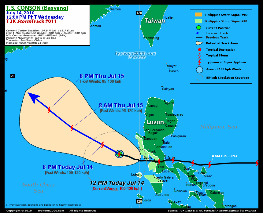
Current Storm Information
Time/Date: 12:00 PM PhT Wed Jul 14 2010
Location of Center: 14.9º N Lat 118.7º E Lon
Distance 1: 145 km (78 nm) WSW of Iba, Zambales
Distance 2: 170 km (92 nm) West of Subic Bay/Olongapo
Distance 3: 260 km (140 nm) WNW of Metro Manila
Distance 4: 505 km (272 nm) WNW of Metro Naga/CWC
Distance 4: 950 km (513 nm) SSE of Hong Kong
MaxWinds (1-min avg): 100 kph (55 kts) near the center
Peak Wind Gusts: 130 kph (85 kts)
6-hr Rain Amounts (near the center): 200 mm [Heavy]
Minimum Central Pressure: 978 millibars (hPa)
Saffir-Simpson Typhoon Scale: TS
Present Movement: WNW @ 30 kph (16 kts)
Towards: Southern China
Size (in Diameter): 555 km (300 nm) / Average
Max Sea Wave Height (near center): 15 ft (4.5 m)
Coastal Storm Surge Height: 0-4 feet [0-1.2 m]
T2K TrackMap #011 (for Public): 12 PM PhT Wed Jul 14
+ Forecast Outlook: CONSON (BASYANG) is expected to continue tracking WNW to NW-ward across the South China Sea for the next 3 days...will exit the Philippine Area of Responsibility (PAR) tomorrow morning [8AM JUL 15: 16.6N 115.6E @ 95kph]. The 4-Day Medium-Range Forecast shows the system making its final landfall on Saturday morning along Western Guangdong (Southern China) or about 370 km. west of Hong Kong [8AM JUL 17: 21.3N 110.8E @ 65kph]. Please be reminded that the Forecast Outlook changes every 6 hours, so a turn to the left or right of its future track and other possibilities must be considered.
+ Effects & Hazards: CONSON's (BASYANG) outer rainbands will still continue to affect Northern Palawan, Calamian Group, Lubang Island & Mindoro - winds not exceeding 50 kph w/ light to moderate rainfall can be expected along these areas. Meanwhile, Metro Manila's skies will clear up later today as the storm moves farther away. 6-hr total rainfall amounts of 5 up to 150 mm (light, moderate to heavy rain) can be expected along the outer and inner rainbands...
PAGASA's Philippine Storm Warnings Signals
PHILIPPINE STORM WARNING SIGNAL # ONE (1)

In Effect: BATANGAS, CAVITE, LUBANG ISLAND, BATAAN, ZAMBALES, NORTHERN MINDORO, AND METRO MANILA.
The above areas will continue to have rains and winds of not more than 60 kph today. Coastal waters will be moderate to rough.
Residents living in low-lying and mountainous areas under Public Storm Warning Signal Number 1 are alerted against flashfloods, mudflows, mudslides and landslides..
External Links for TY CONSON (BASYANG)
View NOAA-CIRA's Latest Wind Analysis
JTWC Latest Tracking Chart: wp0310.gif
Multi-Agency Forecast TrackMap: 12 PM Wed Jul 14
TSR Wind Probabilities: Current to 96 hrs Ahead
Zoomed Satellite Pic: NOAA's Near Real-Time
Wunderground Animation: 6-12 hr. GIF Loop
REMARKS (for Meteorologists): 8AM (00 GMT) WED 14 JULY POSITION: 14.6N 119.7E.
*TROPICAL STORM (TS) 03W (CONSON) HAS CROSSED LUZON INTO THE SOUTH
CHINA SEA AND INTENSIFIED SLIGHTLY AND IS NOW JUST TO THE WEST OF
SUBIC BAY, PHILIPPINES. ANIMATED WATER VAPOR (WV) IMAGERY SHOWS
CONVECTION ASSOCIATED WITH THE SYSTEM REMAINS MOSTLY TO THE SOUTHWEST
OF THE LOW LEVEL CIRCULATION CENTER IN RESPONSE TO MODERATE
NORTHEASTERLY VERTICAL WIND SHEAR (VWS). THE CURRENT POSITION IS
BASED ON MULTIPLE MICROWAVE IMAGES INCLUDING A 132244Z SSMI-S PASS
SHOWING AN EYE-LIKE FEATURE. THE CURRENT INTENSITY IS BASED ON A
UNIFIED DVORAK ESTIMATE FROM PGTW, KNES, AND RJTD OF T3.5 (55 KNOTS).
TS 03W CONTINUES TO TRACK WESTWARD ALONG THE SOUTHERN PERIPHERY OF
THE WESTERN EXTENSION OF A LOW- TO MID-LEVEL STEERING RIDGE TO THE
NORTH. UPPER LEVEL ANALYSIS INDICATES THE SYSTEM IS WELL SOUTH OF THE
RIDGE AXIS IN AN AREA OF MODERATE VERTICAL WIND SHEAR (VWS), AS
EVIDENCED ON THE WV ANIMATION AND ON MICROWAVE IMAGERY...(more)
>> CONSON, meaning: A historical place. Name contributed by: Vietnam.
____________*TROPICAL STORM (TS) 03W (CONSON) HAS CROSSED LUZON INTO THE SOUTH
CHINA SEA AND INTENSIFIED SLIGHTLY AND IS NOW JUST TO THE WEST OF
SUBIC BAY, PHILIPPINES. ANIMATED WATER VAPOR (WV) IMAGERY SHOWS
CONVECTION ASSOCIATED WITH THE SYSTEM REMAINS MOSTLY TO THE SOUTHWEST
OF THE LOW LEVEL CIRCULATION CENTER IN RESPONSE TO MODERATE
NORTHEASTERLY VERTICAL WIND SHEAR (VWS). THE CURRENT POSITION IS
BASED ON MULTIPLE MICROWAVE IMAGES INCLUDING A 132244Z SSMI-S PASS
SHOWING AN EYE-LIKE FEATURE. THE CURRENT INTENSITY IS BASED ON A
UNIFIED DVORAK ESTIMATE FROM PGTW, KNES, AND RJTD OF T3.5 (55 KNOTS).
TS 03W CONTINUES TO TRACK WESTWARD ALONG THE SOUTHERN PERIPHERY OF
THE WESTERN EXTENSION OF A LOW- TO MID-LEVEL STEERING RIDGE TO THE
NORTH. UPPER LEVEL ANALYSIS INDICATES THE SYSTEM IS WELL SOUTH OF THE
RIDGE AXIS IN AN AREA OF MODERATE VERTICAL WIND SHEAR (VWS), AS
EVIDENCED ON THE WV ANIMATION AND ON MICROWAVE IMAGERY...(more)
>> CONSON, meaning: A historical place. Name contributed by: Vietnam.
RECENT TYPHOON2000.
________________________
RECENT MTSAT-1R "DAY & NIGHT VISION" SATELLITE IMAGE:

> Image source: NOAA SATELLITE CENTER
RECENT WUNDERGROUND SATELLITE ANIMATION:

> Image source: Wunderground.com (http://www.wunderground.com/ ) ____________________________________________________________________________________________________________________
> Image source: NOAA SATELLITE CENTER
____________________________________________________________________________________________________________________
RECENT WUNDERGROUND SATELLITE ANIMATION:
> Image source: Wunderground.
LATEST 6 HR. TOTAL RAINFALL AMOUNTS / ENSEMBLE TROPICAL RAINFALL POTENTIAL (eTRaP):

> Image source: NOAA Satellite & Information Service (http://www.ssd.noaa.gov/PS/TROP/etrap.html )____________________________________________________________________________________________________________________
> Image source: NOAA Satellite & Information Service (http://www.ssd.
NOTE:
* - JTWC commentary remarks (for Meteorologists) from their latest warning.
__________________________________________________________________________________________
>> To know the meteorological terminologies and acronyms used on this update visit the ff:
http://typhoon2000.ph/tcterm.htm
http://www.nhc.noaa.gov/aboutgloss.shtml
http://www.srh.noaa.gov/oun/severewx/glossary.php
http://www.srh.weather.gov/fwd/glossarynation.html
http://www.nhc.noaa.gov/acronyms.shtml
__________________________________________________________________________________________
For the complete details on TY CONSON (BASYANG)...go visit our website @:
> http://www.typhoon2000.com
> http://www.maybagyo.com
>> To know the meteorological terminologies and acronyms used on this update visit the ff:
http://typhoon2000.
http://www.nhc.
http://www.srh.
http://www.srh.
http://www.nhc.
____________
>
> http://www.maybagyo
Copyright © 2010 Typhoon2000.
__._,_.___
MARKETPLACE
.
__,_._,___

No comments:
Post a Comment