
for Sunday, 18 July 2010 [12:22 PM PhT]

<<<Typhoon2000.
Get the latest 6-hrly SMS Storm Alerts on TD 98W!
For more details: Text T2K TYPHOON to
2800 (Globe/TM) | 216 (Smart/TNT) | 2288 (Sun)
*only P2.50 (Smart/Globe) / P2.00 (Sun) per msg received.
powered by: Synermaxx
Typhoon2000 (T2K) NEWS (Sun July 18 2010):
Currently issuing the 6-hrly updates web advisiories (except 12 AM HKT) on Tropical Depression 98W (LPA) developing near the coast of Northern Quezon.
98W (UNNAMED) MAX WIND SPEED PER AGENCY:
+ USA (JTWC/1-min avg): 40 km/hr
+ Japan (JMA/10-min avg): 55 km/hr
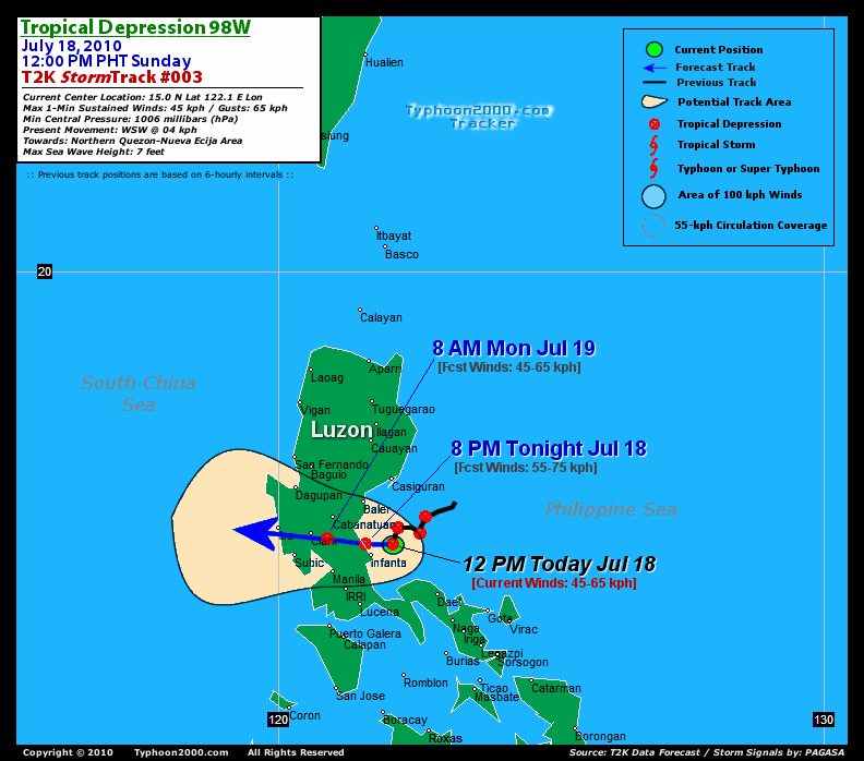
TROPICAL DEPRESSION 98W [UNNAMED]
T2K EMAIL ADVISORY NUMBER 003
12:00 PM PhT (04:00 GMT) Sun 18 July 2010
Source: T2K Analysis/JTWC SatFix
View: Advisory Archives (2004-2010)
*Residents and visitors along Central & Northern Luzon particularly Northern Quezon, Nueva Ecija, Pampanga & Metro Manila should closely monitor the progress of this depression.
*Do not use this for life or death decision. This advisory is intended for additional information purposes only. Kindly refer to your country's official weather agency for local warnings, advisories & bulletins.
Current Storm Information + Forecast Outlook: This depression is expected to make landfall near Infanta tonight and will pass about 55 km. north of Quezon City or 35 km. ESE of Clark/Angeles City around 8AM tomorrow [8PM JUL 18: 15.0N 121.6E @ 55kph...8AM JUL 19: 15.1N 120.9E @ 45kph]. More extended forecast outlook will be posted soon.
Time/Date: 12:00 PM PhT Sun Jul 18 2010
Location of Center: 15.0º N Lat 122.1º E Lon
Distance 1: 50 km (28 nm) ENE of Infanta, Quezon
Distance 2: 105 km (57 nm) SSE of Baler, Aurora
Distance 3: 115 km (62 nm) ENE of Metro Manila
Distance 4: 130 km (70 nm) ESE of Cabanatuan City
Distance 5: 130 km (70 nm) NW of Daet, Cam.Norte
Distance 6: 165 km (90 nm) ESE of Clark/Angeles
Distance 7: 195 km (105 nm) ENE of Subic/Olongapo
Distance 8: 195 km (105 nm) NW of Metro Naga/CWC
MaxWinds (1-min avg): 45 kph (25 kts) near the center
Peak Wind Gusts: 65 kph (35 kts)
6-hr Rain Amounts (near the center): 200 mm [Heavy]
Minimum Central Pressure: 1006 millibars (hPa)
Saffir-Simpson Typhoon Scale: Tropical Depression
Present Movement: WSW @ 04 kph (02 kts)
Towards: Northern Quezon-Nueva Ecija Area
Size (in Diameter): 300 km (160 nm) / Small
Max Sea Wave Height (near center): 7 ft (2.1 m)
Coastal Storm Surge Height: 0 feet [0 m]
T2K TrackMap #003 (for Public): 12 PM PhT Sun Jul 18
+ Effects & Hazards: TD 98W's (UNNAMED) consolidating circulation will continue to affect much of Central & Southern Luzon particularly Northern Quezon & Nueva Ecija incl. Metro Manila, as the system prepares to landfall. Its inner (rain) bands is now spreading across Northern Quezon and Polillo Island...while its outer (feeder) bands has started to affect other parts of Central & Northern Luzon. Moderate winds (30-50 kph) w/ moderate to heavy rains can be expected along its inner bands...while light to moderate winds (10-30 kph) w/ occasional rains is likely along the outer bands. 6-hr total rainfall amounts of 5 up to 100 mm (light, moderate to heavy rain) can be expected along the outer and inner rainbands...
[Important Note: Please keep in mind that the above forecast outlook, effects, current monsoon intensity, & tropical cyclone watch changes every 6 to 12 hrs!]![]()
External Links for 98W (LPA)
View NOAA-CIRA's Latest Wind Analysis
*THE AREA OF CONVECTION PREVIOUSLY LOCATED NEAR 15.2N
122.5E, IS NOW LOCATED NEAR 15.0N 122.2E, APPROXIMATELY 75 NM EAST-
NORTHEAST OF MANILA, PHILIPPINES. ANIMATED MULTISPECTRAL SATELLITE
IMAGERY INDICATES THAT THE SYSTEM HAS CONSOLIDATED OVER THE PAST 12
HOURS AS IT SLOWLY TRACKS TOWARD THE COAST OF LUZON. A RECENT AMSU
CROSS-SECTION SUPPORTS DEPICTS A 1C WARM ANOMALY EVIDENT IN THE MID-
LEVELS. A 172238Z TRMM 85H IMAGE DEPICTS A SMALL SYSTEM WITH CURVED
CONVECTIVE BANDING WRAPPING TIGHTLY INTO A WELL-DEFINED LOW-LEVEL
CIRCULATION CENTER (LLCC). UPPER-LEVEL ANALYSIS DEPICTS A FAVORABLE
ENVIRONMENT WITH AN ANTICYCLONE OVER THE LLCC AND WEAK VERTICAL WIND
SHEAR. THE PROXIMITY TO LAND MAY HINDER FURTHER DEVELOPMENT,
HOWEVER, THE SMALL SIZE OF THE SYSTEM AND POSITION OVER WATER MAY
ALLOW FOR FURTHER STRENGTHENING. MAXIMUM SUSTAINED SURFACE WINDS ARE
ESTIMATED AT 20 TO 25 KNOTS. MINIMUM SEA LEVEL PRESSURE IS ESTIMATED
TO BE NEAR 1006 MB. BASED ON THE IMPROVED CONVECTIVE BANDING, THE
POTENTIAL FOR THE DEVELOPMENT OF A SIGNIFICANT TROPICAL CYCLONE
WITHIN THE NEXT 24 HOURS IS GOOD
RECENT TYPHOON2000 TRACKING CHART:
________________________

> Image source: NOAA SATELLITE CENTER
>> To know the meteorological terminologies and acronyms used on this update visit the ff:
http://typhoon2000.
http://www.nhc.
http://www.srh.
http://www.srh.
http://www.nhc.
____________
>
> http://www.maybagyo
Copyright © 2010 Typhoon2000.

No comments:
Post a Comment