
for Monday, 12 July 2010 [6:36 AM PhT]

<<<Typhoon2000.
Get the latest 6-Hrly SMS Storm Alerts on BASYANG!
For more details: Text T2K TYPHOON to
2800 (Globe/TM) | 216 (Smart/TNT) | 2288 (Sun)
*only P2.50 (Smart/Globe) / P2.00 (Sun) per msg received.
powered by: Synermaxx
Typhoon2000 (T2K) NEWS (Mon July 12 2010):
Now issuing 6-hrly advisories (except 12 AM PhT) on TS 03W (BASYANG).
03W (BASYANG) MAX WIND SPEED PER AGENCY:
+ USA (JTWC/1-min avg): 65 km/hr
+ Japan (JMA/10-min avg): 55 km/hr
+ Philippines (PAGASA/10-min avg): 55 km/hr
TROPICAL STORM 03W [BASYANG]
T2K PUBLIC ADVISORY NUMBER 002
6:00 AM PhT (22:00 GMT) Mon 12 July 2010
Source: T2K Analysis/JTWC Warning #002
View: Advisory Archives (2004-2010)
*Residents and visitors along Bicol Region and Luzon should closely monitor the progress of 03W.
*Do not use this for life or death decision. This advisory is intended for additional information purposes only. Kindly refer to your country's official weather agency for local warnings, advisories & bulletins.
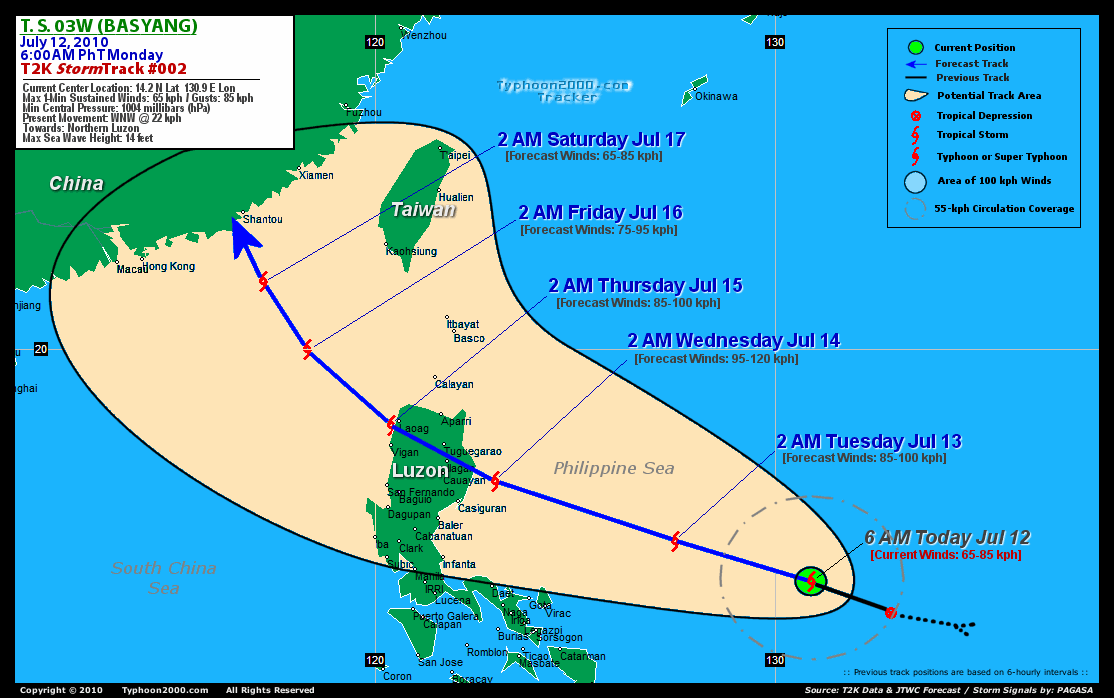
Current Storm Information
Time/Date: 6:00 AM PhT Mon Jul 12 2010
Location of Center: 14.2º N Lat 130.9º E Lon
Distance 1: 725 km (390 nm) ENE of Virac, Catanduanes
Distance 2: 765 km (413 nm) ENE of Gota, Caramoan
Distance 3: 785 km (425 nm) ENE of Legazpi City
Distance 4: 835 km (450 nm) ENE of Metro Naga/CWC
Distance 5: 970 km (525 nm) ESE of Casiguran, Aurora
Distance 6: 1,055 km (570 nm) ESE of Metro Manila
MaxWinds (1-min avg): 65 kph (35 kts) near the center
Peak Wind Gusts: 85 kph (45 kts)
6-hr Rain Amounts (near the center): 110 mm [Moderate]
Minimum Central Pressure: 1004 millibars (hPa)
Saffir-Simpson Typhoon Scale: TS
Present Movement: WNW @ 22 kph (12 kts)
Towards: Northern Luzon
Size (in Diameter): 300 km (160 nm) / Small
Max Sea Wave Height (near center): 14 ft (4.2 m)
Coastal Storm Surge Height: <4 feet [<1.2 m]
T2K TrackMap #002 (for Public): 6 AM PhT Mon Jul 12
+ Forecast Outlook: 03W (BASYANG) is expected to maintain its WNW track throughout its forecast and intensify as it moves towards Northern Luzon [2AM JUL 13: 15.2N 127.5E]. It will reach its peak strength of 95 kph by tomorrow & make landfall somewhere in Southern Isabela [2 AM JUL 14: 16.7N 123.0E] by Wednesday morning Jul 14. 03W is expected to lose strength upon traversing the mountainous terrain of Northern Luzon Wednesday morning until the evening. The 3 to 5-Day Long-Range Forecast shows the system exiting Ilocos Provinces by early Thursday [2AM JUL 15: 18.1N 120.4E] and will be in the middle of the South China Sea on Friday as it approaches Southern China on Saturday [2AM JUL 16: 20.0N 118.3E...2AM JUL 17: 21.7N 117.2E].
+ Effects & Hazards: 03W's (BASYANG) compact circulation continues to improve while it remains over the Philippine Sea...no effects & hazards are in place at this time. 6-hr total rainfall amounts of 5 up to 75 mm (light to moderate rain) can be expected along its rainbands...
[Important Note: Please keep in mind that the above forecast outlook, effects, current monsoon intensity, & tropical cyclone watch changes every 6 to 12 hrs!]
PAGASA's Philippine Storm Warnings Signals
PHILIPPINE STORM WARNING SIGNAL # ONE (1)

Now In Effect: CAGAYAN, ISABELA AND AURORA.
The above areas will have rains and winds of not more than 60 kph can be expected beginning tomorrow. Coastal waters will be moderate to rough.
Residents living in low-lying and mountainous areas under Public Storm Warning Signal Number 1 are alerted against flashfloods, mudflows, mudslides and landslides..
External Links for TS 03W (BASYANG)
View NOAA-CIRA's Latest Wind Analysis
JTWC Latest Tracking Chart: wp0310.gif
TSR Wind Probabilities: Current to 24 hrs Ahead
Zoomed Satellite Pic: NOAA's Near Real-Time
Wunderground Animation: 6-12 hr. GIF Loop
2 PM (06 GMT) 12 JULY: 14.6N 129.7E / 75-95 KPH (TS) / WNW @ 20 KPH
2 AM (18 GMT) 13 JULY: 15.2N 127.5E / 85-100 KPH (TS) / WNW @ 20 KPH
2 AM (18 GMT) 14 JULY: 16.7N 123.0E / 95-120 KPH (TS) / WNW @ 13 KPH
REMARKS (for Meteorologists)
*THE SYSTEM WAS UPGRADED TO A TROPICAL STORM BASED ON A 111201Z ASCAT PASS
DEPICTING 35 KNOT WINDS ON THE EASTERN PERIPHERY OF THE SYSTEM AND A DVORAK
ESTIMATE FROM PGTW 0F 35 KNOTS. ANIMATED INFRARED SATELLITE IMAGERY AND A
1:30 AM 36 GHZ AMSRE MICROWAVE IMAGE INDICATE THAT TS 03W HAS CONTINUED TO
CONSOLIDATE WITH INCREASED DEEP CONVECTION AND TIGHTLY CURVED
BANDING FEATURES WRAPPING INTO A WELL DEFINED LOW LEVEL CIRCULATION
CENTER (LLCC)....(more)
____________
PAGASA CURRENT POSITION, MOVEMENT AND INTENSITY (10-min. ave.):
> 4 AM (20 GMT) MON 12 JULY: 14.4N 131.0E / WNW @ 22 kph / 55 kph
:: For the complete PAGASA bulletin, kindly visit their website at:
http://www.pagasa.dost.gov.ph/wb/tcupdate.shtml
_______________________________________________________________________________________________________________________________________
:: For the complete PAGASA bulletin, kindly visit their website at:
http://www.pagasa.
____________
RECENT TYPHOON2000.
________________________
RECENT MTSAT-1R "DAY & NIGHT VISION" SATELLITE IMAGE:

> Image source: NOAA SATELLITE CENTER
RECENT WUNDERGROUND SATELLITE ANIMATION: ***WARNING!!! THE ANIMATION IS NOT YET ALIGN WITH THE LAND FEATURES.***

> Image source: Wunderground.com (http://www.wunderground.com/ ) ____________________________________________________________________________________________________________________
> Image source: NOAA SATELLITE CENTER
____________________________________________________________________________________________________________________
RECENT WUNDERGROUND SATELLITE ANIMATION: ***WARNING!!
> Image source: Wunderground.
LATEST 6 HR. TOTAL RAINFALL AMOUNTS / ENSEMBLE TROPICAL RAINFALL POTENTIAL (eTRaP):

> Image source: NOAA Satellite & Information Service (http://www.ssd.noaa.gov/PS/TROP/etrap.html )____________________________________________________________________________________________________________________
> Image source: NOAA Satellite & Information Service (http://www.ssd.
NOTE:
* - JTWC commentary remarks (for Meteorologists) from their latest warning.
__________________________________________________________________________________________
>> To know the meteorological terminologies and acronyms used on this update visit the ff:
http://typhoon2000.ph/tcterm.htm
http://www.nhc.noaa.gov/aboutgloss.shtml
http://www.srh.noaa.gov/oun/severewx/glossary.php
http://www.srh.weather.gov/fwd/glossarynation.html
http://www.nhc.noaa.gov/acronyms.shtml
__________________________________________________________________________________________
For the complete details on TS 03W (BASYANG)...go visit our website @:
> http://www.typhoon2000.com
> http://www.maybagyo.com
>> To know the meteorological terminologies and acronyms used on this update visit the ff:
http://typhoon2000.
http://www.nhc.
http://www.srh.
http://www.srh.
http://www.nhc.
____________
>
> http://www.maybagyo
Copyright © 2010 Typhoon2000.
__._,_.___
MARKETPLACE
.
__,_._,___

No comments:
Post a Comment